Gabe Prough

5.9K posts

Gabe Prough banner
Gabe Prough

Gabe Prough

@proughwx

Emmy award-winning Meteorologist @who13news | @ballstate Alum | ‘19 NOAA Hollings Scholar/@NWSBismarck Intern | Formerly @abc21wpta @NLIWeather @cardinal_wx

Des Moines, IA เข้าร่วม Ekim 2011
1.4K กำลังติดตาม1.4K ผู้ติดตาม
Gabe Prough
Gabe Prough@proughwx·
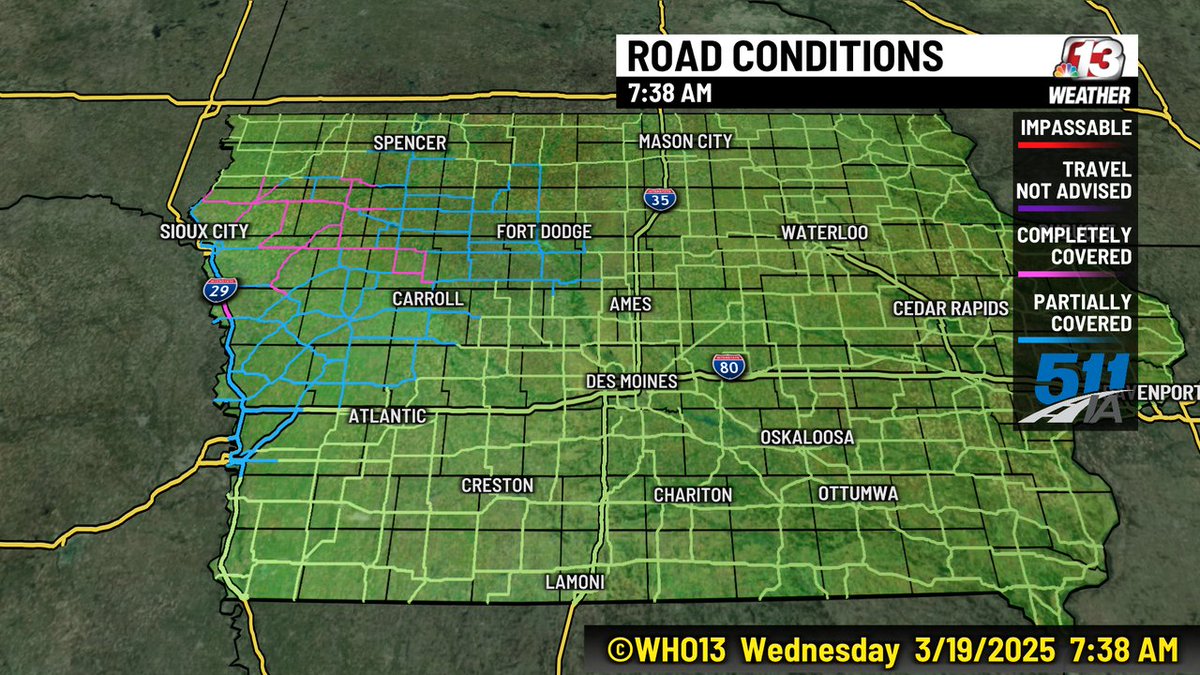
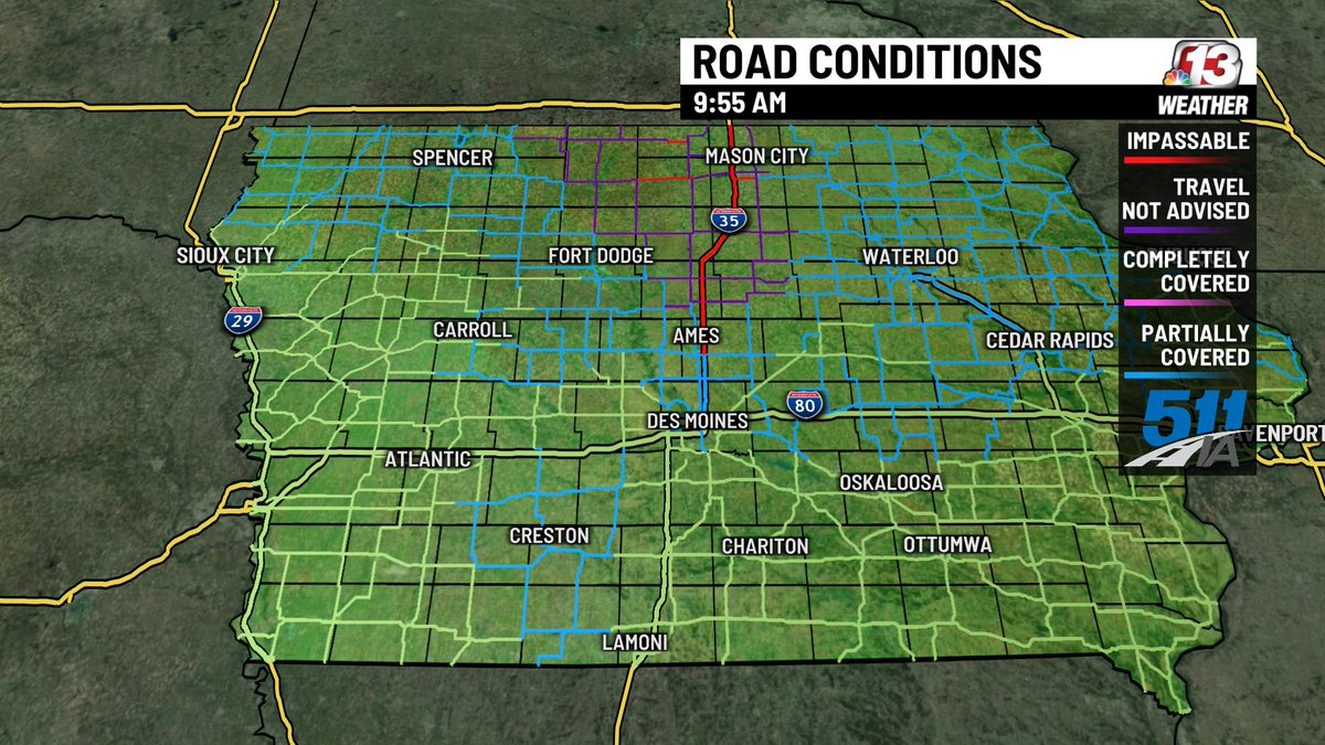
As of this morning, I-35 is still shut down from Ames to the MN state line due to blowing and drifting snow. There are still bad conditions across much of northern Iowa. The DOT hopes to open I-35 by this afternoon, and decreasing winds will help crews clear the roads #IAwx
Gabe Prough tweet media
English
1
1
2
645
Gabe Prough
Gabe Prough@proughwx·
A Dense Fog Advisory is in effect for most of central and southern Iowa until 9AM this morning. Turn those low beams on and have a bit more following distance if you're out and about! #IAwx
Gabe Prough tweet media
English
0
0
2
309
Gabe Prough
Gabe Prough@proughwx·
A Severe Thunderstorm Warning has been issued for parts of Boone, Dallas, Greene, Guthrie, Madison, and Polk counties until 5:45AM. This storm has shown a history of producing gusty winds. #IAwx
Gabe Prough tweet media
English
0
0
3
301
Gabe Prough
Gabe Prough@proughwx·
A Severe Thunderstorm Warning has been issued for parts of Adair, Adams, Audubon, Cass, Dallas, Guthrie, and Madison counties until 5AM. This storm could produce 70mph wind gusts! #IAwx
Gabe Prough tweet media
English
0
0
2
235
Gabe Prough
Gabe Prough@proughwx·
A Severe Thunderstorm Watch has been issued until 8AM for central and southern Iowa. A large complex of storms will bring the potential for damaging winds through the early morning hours. #IAwx
Gabe Prough tweet media
English
0
0
1
158
Gabe Prough
Gabe Prough@proughwx·
A Severe Thunderstorm Warning has been issued for parts of Calhoun and Webster counties until 8:15AM. These storms have had a history of producing damaging winds. #IAwx
Gabe Prough tweet media
English
0
0
2
595
Gabe Prough
Gabe Prough@proughwx·
A Severe Thunderstorm Warning has been issued for parts of Audubon, Carroll, and Greene counties until 7:45AM. Strong winds are the main threat. #IAwx
Gabe Prough tweet media
English
0
1
2
847
Gabe Prough
Gabe Prough@proughwx·
A Severe Thunderstorm Watch has been issued until noon today. A very strong complex of storms is moving out of Nebraska, carrying a risk for damaging winds. Stay weather aware this morning! #IAwx
Gabe Prough tweet media
English
0
3
3
1K
Gabe Prough
Gabe Prough@proughwx·
A Heat Advisory is back in effect Sunday from 12PM to 8PM for most of central Iowa. It will feel around 105-110°, so stay cool! #IAwx
Gabe Prough tweet media
English
0
0
2
187
Gabe Prough
Gabe Prough@proughwx·
7AM Radar Update: Showers and storms are ending across central Iowa, but several Flash Flood Warnings are in place across the state. Be alert for flooded areas as you head out this morning. #IAwx
Gabe Prough tweet media
English
0
0
4
246
Gabe Prough
Gabe Prough@proughwx·
A Severe Thunderstorm Watch has been issued for central and eastern Iowa until 10AM. This line of storms will have the potential to produce strong winds, heavy rain, and lightning as it moves in. #IAwx
Gabe Prough tweet media
English
0
0
1
355
Gabe Prough
Gabe Prough@proughwx·
An Excessive Heat Watch has been issued for all of central Iowa from Saturday Afternoon to Sunday Evening. Some extreme heat is headed our way--the heat index is expected to reach well into the triple digits. #IAwx
Gabe Prough tweet media
English
0
0
1
205
Gabe Prough รีทวีตแล้ว
NWS Des Moines
NWS Des Moines@NWSDesMoines·
Monday Severe Storms Outlook - Severe Weather Outbreak Forecast A Moderate Risk (4/5) of Severe Storms over most of Iowa. Severe weather outbreak is forecast for Monday over Iowa and nearby states. Strong tornadoes along with large hail and damaging winds will be possible. #iawx
NWS Des Moines tweet media
English
4
97
474
42.4K
Gabe Prough รีทวีตแล้ว
Megan Salois 💧☔️☀️
RADAR UPDATE 6:20 AM 4/17/25: Spotty thunderstorms are popping up east of Des Moines between Grinnell and Cedar Rapids. These storms are bringing brief heavy downpours and are lifting northeast away from Central Iowa. #iawx
English
0
1
4
660
Gabe Prough
Gabe Prough@proughwx·
Here's a snapshot from the Iowa DOT camera at the I-80/I-880 interchange near the Minden/Yorkshire area. Traffic is backed up and roads are closing in this area. Travel will be a nightmare in western Iowa today. #IAwx
Gabe Prough tweet media
English
0
1
3
350
Gabe Prough
Gabe Prough@proughwx·
Road conditions are starting to go downhill in northwestern Iowa with some roads becoming partially to completely covered. Travel will be nearly impossible in this part of the state later today. #IAwx
Gabe Prough tweet media
English
0
0
0
203
Gabe Prough
Gabe Prough@proughwx·
A Severe Thunderstorm Warning has been issued for parts of Butler and Hardin counties until 6:15AM. Hail near 1" in diameter is possible with this storm. #IAwx
Gabe Prough tweet media
English
0
1
1
175
Gabe Prough
Gabe Prough@proughwx·
A Severe Thunderstorm Warning has been issued for parts of Dallas and Boone counties until 4:30AM. This storm could produce quarter sized hail. #IAwx
Gabe Prough tweet media
English
0
0
0
117
Gabe Prough
Gabe Prough@proughwx·
A Severe Thunderstorm Warning is in effect for parts of Mahaska, Marion, and Poweshiek counties until 4:15AM. This storm could produce quarter-sized hail. #IAwx
Gabe Prough tweet media
English
0
0
0
93
Gabe Prough
Gabe Prough@proughwx·
What a difference a day makes! Most locations are around 40° colder right now compared to this time yesterday. We tied the record high of 81° yesterday; today we've spent most of the day in the 30s and low 40s. #IAwx
Gabe Prough tweet media
English
1
1
2
302