Weatherman Navdeep Dahiya@navdeepdahiya55
Much-awaited relief from the heatwave ahead as summer storms are set to take over #India early next week
Meteorological Context
• A spell of heatwave usually triggers summer storms in India. These are WD/LWD-led patterns supported by moisture-laden winds from the Arabian Sea and the Bay of Bengal, forming inland cyclonic circulations. This setup triggers strong dust storms, thundershowers, and gusty winds during the evening to night hours while moving from west to east.
What to Expect in This Spell
• Strong dust storms (40–80 km/h wind gusts), followed by short spells of moderate to heavy intensity rain and thundershowers, usually lasting 15–45 minutes. Some areas may observe sustained drizzle for 2–3 hours after the passage of a storm.
• Thunderstorms will carry lightning strikes and rumbling thunder. The risk of hailstorms remains on the lower side, but isolated events cannot be ruled out.
• Most activity will occur between 2 PM and 10 PM each day. Some storms may spill over into the next day, but with limited geographical coverage.
Date-wise Impact
• 27th April: Rajasthan, Haryana, Delhi NCR (30–50% coverage)
• 28th–30th April (Peak): Punjab, Haryana, Rajasthan, Delhi NCR, Uttar Pradesh, Bihar, Jharkhand, Odisha, Chhattisgarh, Karnataka, Telangana, Kerala (50–75% coverage)
Madhya Pradesh, Maharashtra, Andhra Pradesh (10–30% coverage)
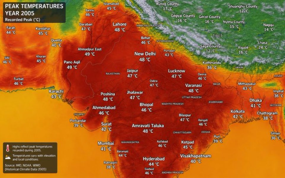
Impact on Temperature
• Heatwave conditions will continue on Monday. Temperatures are expected to fall from Tuesday evening in rain-affected regions.
• Maximum temperatures are likely to drop to the range of 36–41°C across most areas from Wednesday onwards, compared to the current 42–46°C.
• This indicates that the heatwave will abate, but hot afternoons will persist with slight humidity due to changing wind patterns.
• Evenings and nights in rain-affected cities will become relatively pleasant.
Safety Concerns
• These summer storms, especially during the evening hours, can be intense—particularly in terms of wind speeds, which may occasionally reach up to 100 km/h.
• If you observe dark clouds approaching from the west and hear thunder, it is strongly advisable to stay indoors until the storm passes.
• After the initial dust/wind front, rainfall with lightning typically follows—wait for this phase to pass before stepping outdoors.
Large parts of Gujarat, Madhya Pradesh, and Maharashtra are unlikely to experience significant relief and will continue to witness #heatwave conditions next week.
This is a pan-India outlook; day-wise impacts and timings will vary by region. As the WDs arrive and development begins, it is best to track nowcasts based on cloud movement to assess when your area may be impacted.
Updates for major cities will be shared as activity begins from tomorrow onwards—better to stay prepared than be caught off guard.