Yes Data

2.5K posts

Yes Data banner
Yes Data

Yes Data

@yesdata_

Data-driven visuals and statistics focused on economics, health or human resources. Tools in posts, all visuals are original. 📊🗺️📸

France เข้าร่วม Temmuz 2023
43 กำลังติดตาม7.9K ผู้ติดตาม
ทวีตที่ปักหมุด
Yes Data
Yes Data@yesdata_·
☔️ Series: Rainfall (No. 6) - Japan Japan's rainy season, tsuyu, brings heavy rainfall from June to mid-July. 🔧 Tools: Python (Rasterio, Rioxarray, Geopandas)
Yes Data tweet media
English
0
0
7
889
Yes Data
Yes Data@yesdata_·
🐔 Series: Chicken Density (No. 3) - Indonesia Indonesia has a massive chicken population, supporting its huge poultry industry. 🔧 Tools: Python (Rasterio, Geopandas, Shapely)
Yes Data tweet media
English
0
0
5
931
Yes Data
Yes Data@yesdata_·
🚗 Series: Roads (No. 6) - India India's 6.3 million km road network, the world's second largest, connects cities and villages, driving economic growth. 🔧 Tools: Python (Pandas, Geopandas, Matplotlib)
Yes Data tweet media
English
0
0
4
5.1K
Yes Data รีทวีตแล้ว
Simon Kuestenmacher
Simon Kuestenmacher@simongerman600·
This map by @yesdata_ shows the population density across North America.
Simon Kuestenmacher tweet media
English
17
121
924
73.4K
Yes Data
Yes Data@yesdata_·
🗺️ Series: Population Density (No. 12) - North America North America's population density averages about 22 people per square kilometer, with significant regional variations. 🔧 Tools: Python (Rasterio, Geopandas, Shapely)
Yes Data tweet media
English
3
14
77
109.6K
Yes Data
Yes Data@yesdata_·
🚗 Series: Roads (No. 5) - Thailand Thailand's road network connects Bangkok to regional centers with major highways, while rural roads vary in quality. 🔧 Tools: Python (Pandas, Geopandas, Matplotlib)
Yes Data tweet media
English
0
1
9
1.9K
Yes Data
Yes Data@yesdata_·
🗺️ Series: Population Density (No. 11) - South America South America's population density is starkly uneven, clustering in cities while thinning out in rural and wilderness areas. 🔧 Tools: Python (Rasterio, Geopandas, Shapely)
Yes Data tweet media
English
0
1
14
1.3K
Yes Data
Yes Data@yesdata_·
🐮 Series: Cattle Density (No. 5) - India India has one of the highest cattle densities globally due to its large bovine population and limited agricultural land. 🔧 Tools: Python (Rasterio, Geopandas, Shapely)
Yes Data tweet media
English
0
0
7
1.6K
Yes Data
Yes Data@yesdata_·
🗺️ Series: UNESCO World Heritage Sites (No. 4) - North America North America hosts UNESCO World Heritage Sites like Yellowstone and Chichen Itza, valued for their natural and cultural significance. 🔧 Tools: Python (Geopandas, Shapely, Contextily)
Yes Data tweet media
English
0
0
6
5.8K
Yes Data
Yes Data@yesdata_·
👨‍🌾 Series: HDI (No. 6) - North America The Human Development Index assesses development via health, education, and living standards. The dataset contains anomalies. Values are estimates. 🔧 Tools: Python (Rasterio, Rioxarray, Shapely)
Yes Data tweet media
English
0
0
6
4.7K
Yes Data
Yes Data@yesdata_·
🧯 Series: Fires (No. 4) - Japan NASA uses its satellites to detect sources of heat on Earth. This map shows 2023 signals. It only shows 'type 0' heat sources (presumed vegetation fire) with confidence 'h' (high). 🔧 Tools: Python (Geopandas, Shapely, Contextily)
Yes Data tweet media
English
0
1
3
1.7K
Yes Data
Yes Data@yesdata_·
💧 Series: Rivers (No. 5) - Germany Germany's river system, including major rivers like the Rhine, Danube, and Elbe, plays a vital role in transportation, trade, and supporting diverse ecosystems across the country. 🔧 Tools: Python (Pandas, Geopandas, Shapely)
Yes Data tweet media
English
0
2
11
3.1K
Yes Data
Yes Data@yesdata_·
☔️ Series: Rainfall (No. 5) - Africa Africa's precipitation varies widely, with tropical regions like Central Africa receiving heavy rainfall, while vast deserts like the Sahara experience minimal precipitation. 🔧 Tools: Python (Rasterio, Rioxarray, Geopandas)
Yes Data tweet media
English
1
0
11
1.4K
Yes Data
Yes Data@yesdata_·
💧 Series: Rivers (No. 4) - Türkiye Türkiye's river system includes major rivers like the Euphrates, Tigris, and Kızılırmak, which flow through diverse landscapes, supporting agriculture, hydropower, and ecosystems. 🔧 Tools: Python (Pandas, Geopandas, Shapely)
Yes Data tweet media
Română
1
1
7
2.6K
Yes Data
Yes Data@yesdata_·
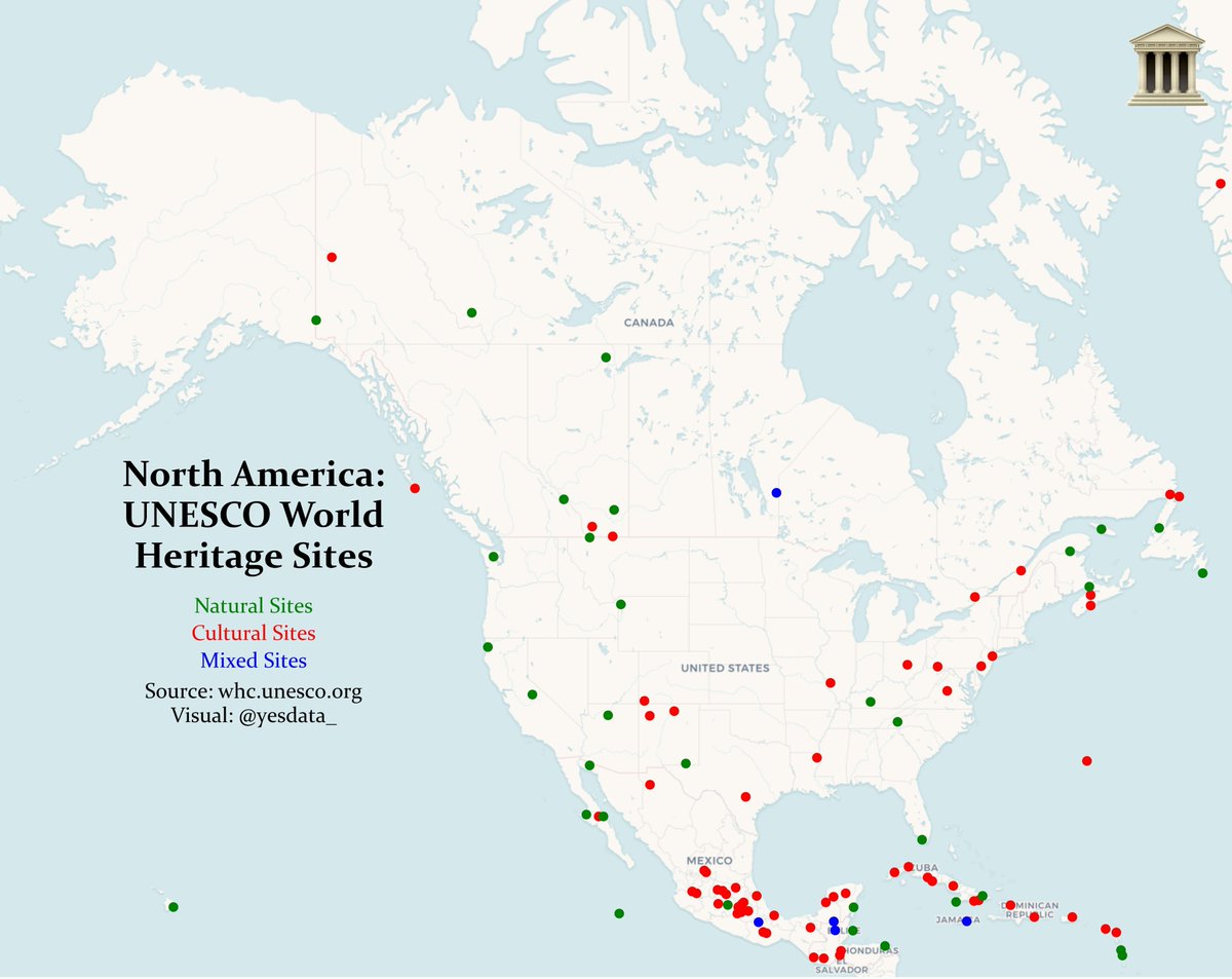
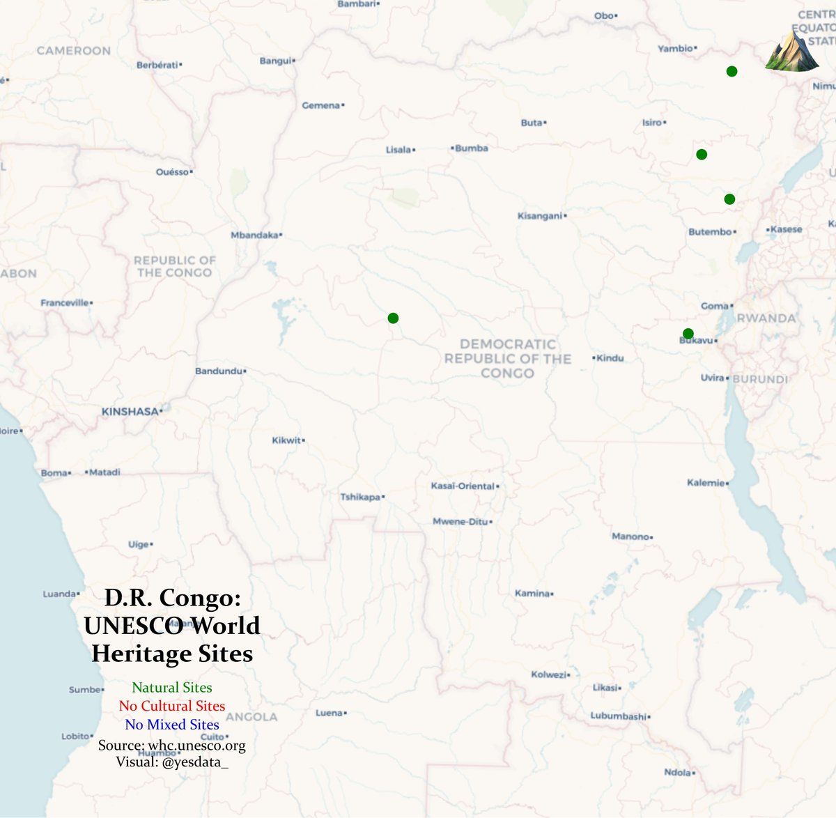
🗺️ Series: UNESCO World Heritage Sites (No. 3) - D.R. Congo The D.R. Congo is home to five UNESCO World Heritage Sites, including Virunga National Park, known for its diverse ecosystems and endangered mountain gorillas. 🔧 Tools: Python (Geopandas, Shapely, Contextily)
Yes Data tweet media
English
0
0
1
1.8K
Yes Data
Yes Data@yesdata_·
💧 Series: Rivers (No. 3) - Nigeria Nigeria's Niger and Benue rivers form a vital confluence at Lokoja, driving ecosystems and culture. 🔧 Tools: Python (Pandas, Geopandas, Shapely)
Yes Data tweet media
English
0
2
19
37.7K
Yes Data
Yes Data@yesdata_·
👨‍🌾 Series: HDI (No. 5) - Brazil The Human Development Index assesses development via health, education, and living standards. The dataset contains anomalies. Values are estimates. 🔧 Tools: Python (Rasterio, Rioxarray, Shapely)
Yes Data tweet media
English
0
0
7
6.2K
Yes Data
Yes Data@yesdata_·
🚗 Series: Roads (No. 4) - Czechia Czechia's road network is extensive and well-maintained, with a radial structure centered around Prague and ongoing modernization efforts. 🔧 Tools: Python (Pandas, Geopandas, Matplotlib)
Yes Data tweet media
English
0
1
12
48.2K
Yes Data รีทวีตแล้ว
Simon Kuestenmacher
Simon Kuestenmacher@simongerman600·
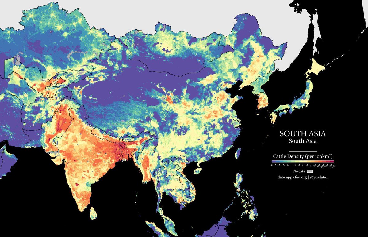
Holy cow! South Asia’s cattle density really is highest in India. HT @yesdata_ (give them a follow)
Simon Kuestenmacher tweet media
English
11
8
55
7.2K
Yes Data รีทวีตแล้ว
Simon Kuestenmacher
Simon Kuestenmacher@simongerman600·
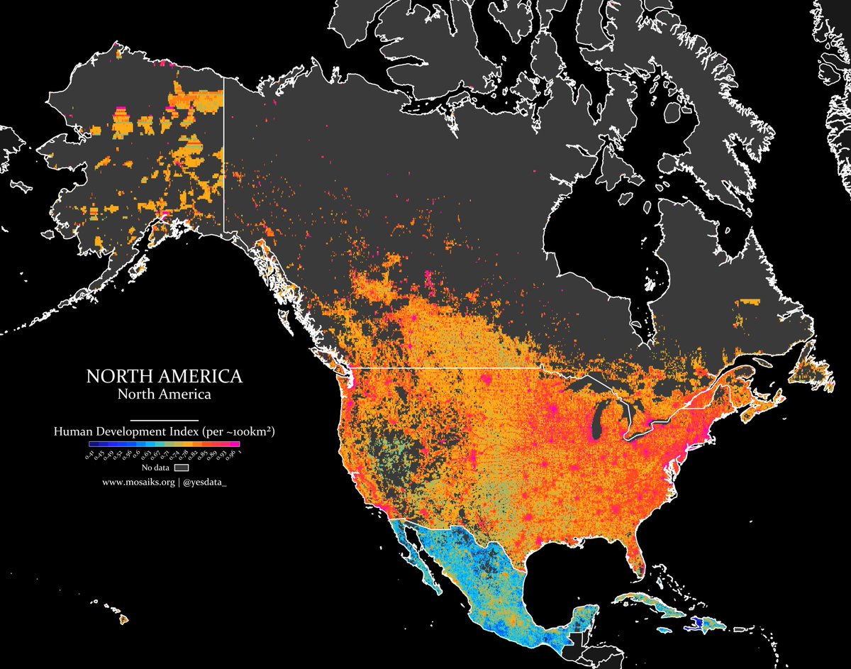
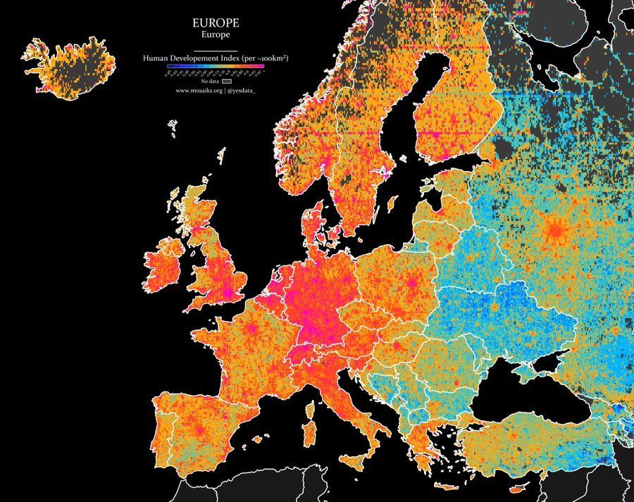
Wonderfully detailed map shows the Human Development Index across Europe. Concentration of development in Central Europe generally and within the big cities within each individual country. HT @yesdata_
Simon Kuestenmacher tweet media
English
17
92
326
41.9K