پن کیا گیا ٹویٹ
ᴍᴀɴᴅᴇʜ
25.1K posts


ᴍᴀɴᴅᴇʜ
@mandehbutton
90% coffee, 10% funny. Game addict, nerd, ex-WoW tryhard. If I was funny, I would have a good Twitter bio.
Pittsburgh, PA شامل ہوئے Nisan 2011
2K فالونگ2.1K فالوورز
ᴍᴀɴᴅᴇʜ ری ٹویٹ کیا

Kinda wish the original creator would re make this given everything going on in the world ATM
youtu.be/nZMwKPmsbWE?si…

YouTube
English
I made a Gen Zer listen to Ice Ice Baby today and the interaction went like this:
Her: ew this song is 17 years old?
Me: … what???
Her: see! YouTube says 17 years
Me: .. ???..That’s when it was uploaded on YouTube it’s much older than that
Her: 😯
Me: get out of my office..
English

After 15 years and over 4,000 videos on this platform, my beloved Shiba Inu dog Bumi has peacefully passed away. He entertained millions of people online and tens of thousands in person at conventions. This video is Bumi doing what he did best in life, making people happy.
English


ᴍᴀɴᴅᴇʜ ری ٹویٹ کیا

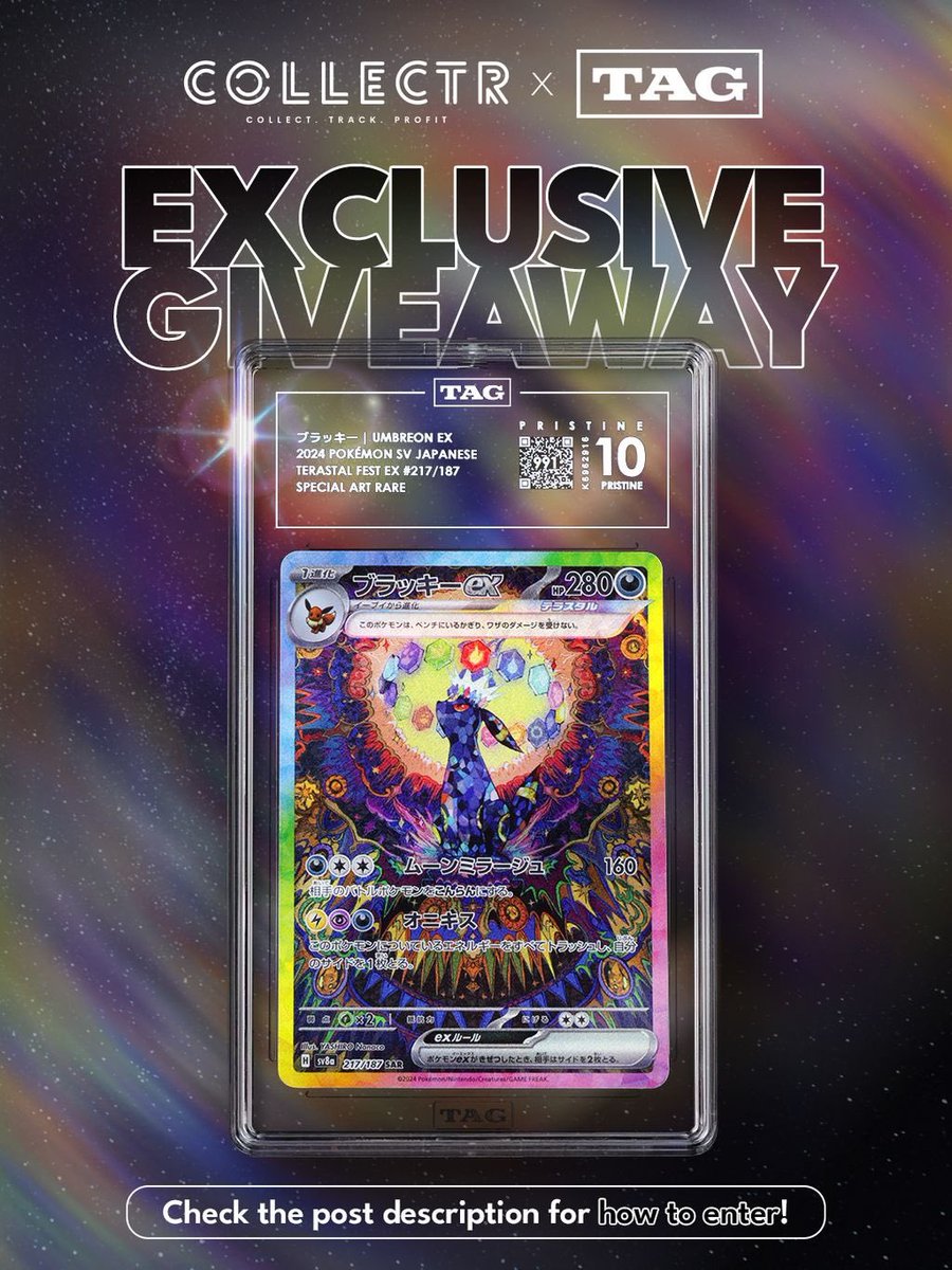
🌙 POKÉMON DAY GIVEAWAY ✨
Win a TAG PRISTINE 10 (991) UMBREON EX SAR
How to enter:
1️⃣ Like ❤️ & Repost 🔁
2️⃣ Follow @getcollectr + @taggrading
3️⃣ Reply with your favorite Gen 10 starter: Pombon, Browt, or Gecqua!
PRISTINE is achieved by <1% of TAG submissions. This 991 is tied for the 15th highest TAG-graded copy in the world. #1 CROWN PRISTINE currently held by a TAG 996.
Winner announced March 7 🌊
#PokemonDay #Pokemon #pombon #browt #gecqua
English
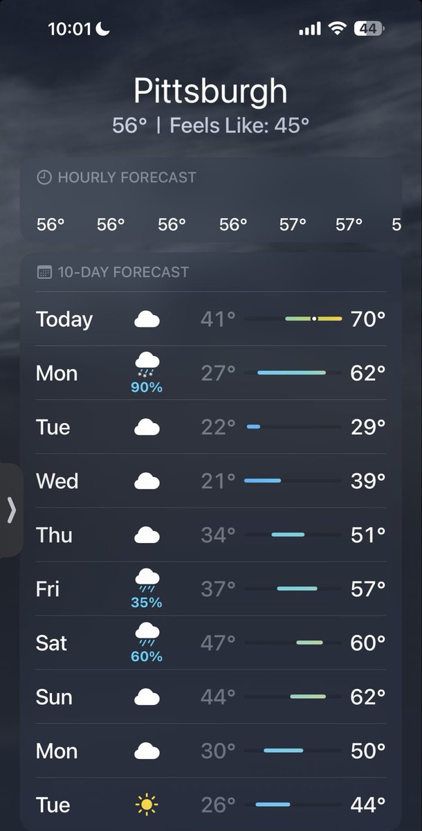
We ended up getting almost no snow. Be safe and be careful to everyone that did
ᴍᴀɴᴅᴇʜ@mandehbutton
I can’t deal with more snow at this point 🫠🫠
English
ᴍᴀɴᴅᴇʜ ری ٹویٹ کیا

HBO posted this in response to the ‘A Knight of the Seven Kingdoms’ review bombing from Breaking Bad fans ☠️😭
English
@mandehbutton I wish I lived somewhere that got snow ❄️ 😕
English
I can’t deal with more snow at this point 🫠🫠
joseph martucci@jtooch07
2/22-23/26 POSSIBLE BLIZZARD: FIRST CALL FORECAST Good evening everyone! I hope you're all doing well! Attached below is my first forecast for the impending nor'easter that I'm expecting that could turn into a blizzard for the northeastern United States this Sunday into the daytime on Monday. I'm expecting a very strong system--here's what I know. We have a favorable ridge setting up over NW Montana and Idaho that has been trending more and more amplified across all data in the last 24-36 hours. Downstream, this is causing our trough to dig VERY deep across the Eastern U.S., which is allowing for more separation of our 50/50 low. This is causing our block (-NAO) to have more of an impact on the storm's evolution--slowing it down, while providing some cold air. With the ridge out west, this trough looks to go negative pretty quickly, causing a low pressure system to take shape and, in my opinion, tuck pretty close off the coast of New Jersey and Long Island overnight Sunday into Monday, then heading east past coastal Southern New England Monday evening. What this'll allow for is a strong system with abundant frontogenesis, particularly at 700mb and 800mb, which would induce heavy snowfall rates of 2-3"/hour for a large region. An inverted trough at onset will provide a localized swath of higher amounts--my highest confidence in this remains it being somewhere in Central Pennsylvania. With a strong system like this, we will also have strong winds and erosion near and along the coasts. Winds will likely be up to 20mph, gusting to 40mph at times especially along the coast. This would be conducive for blizzard conditions, at times, primarily east of I-95 and along the coast. This is a first call, and I do think there will be adjustments, but at the moment, I'm remaining confident that we will see a major winter storm develop on Sunday that will bring impacts to the entire region. Updates will be on the way and a final snowfall map will be issued tomorrow evening. Regardless of the scale of impact, begin preparing now. Have a great evening everyone! #PAwx #NJwx #NYwx #MAwx #CTwx #RIwx #VTwx #NHwx #MDwx #DEwx #VAwx #WVwx #OHwx
English
ᴍᴀɴᴅᴇʜ ری ٹویٹ کیا

The latest episode of AKOTSK is a fucking 10/10. The most brutal depiction of combat I think they’ve ever had in thrones history.
I am jaw dropped at what I just saw. Peak television
I MEAN PEAK
100/10!!!! 🙏
English
ᴍᴀɴᴅᴇʜ ری ٹویٹ کیا

ᴍᴀɴᴅᴇʜ ری ٹویٹ کیا
