SynMax Maritime

404 posts

SynMax Maritime banner
SynMax Maritime

SynMax Maritime

@SynMaxInt

Theia by SynMax: An AI-powered sentinel for the high seas, detecting maritime deception & ensuring data transparency. @SynMaxData

Houston, TX and London, UK Tham gia Nisan 2023
46 Đang theo dõi1.7K Người theo dõi
SynMax Maritime
SynMax Maritime@SynMaxInt·
We are delighted to have supported the Financial Times in their investigation into the global shadow fleet. The interactive article examines how Russia's seaborne oil exports have continued to flow despite Western sanctions, sustained by an ecosystem of ageing tankers with opaque ownership structures, and a history of deceptive shipping practices. The FT demonstrates that the shadow fleet is no longer a fringe phenomenon, but a substantial and adaptive system that reconfigures itself in response to enforcement pressure and commercial opportunity. 
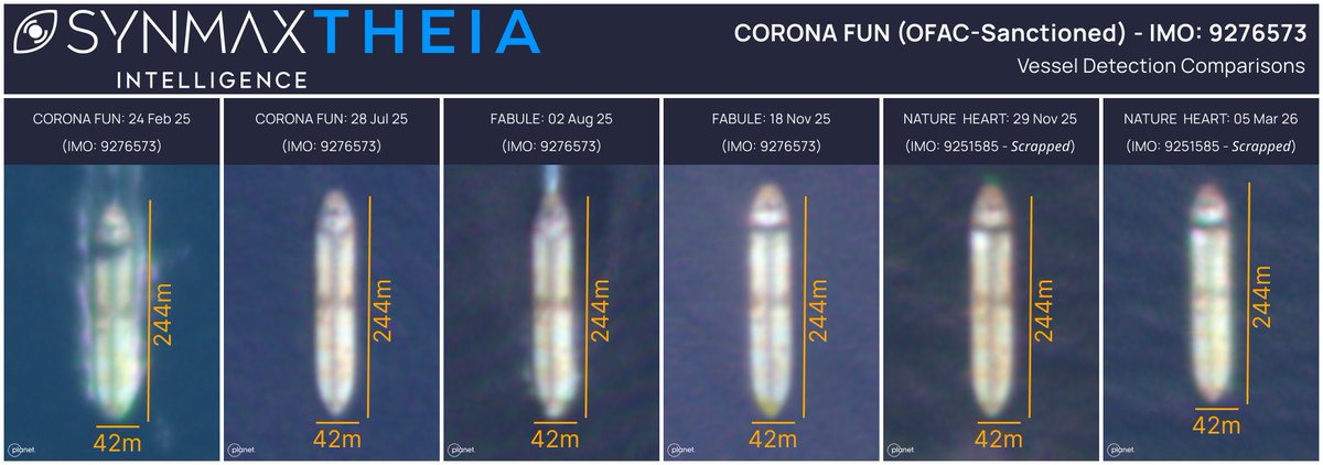
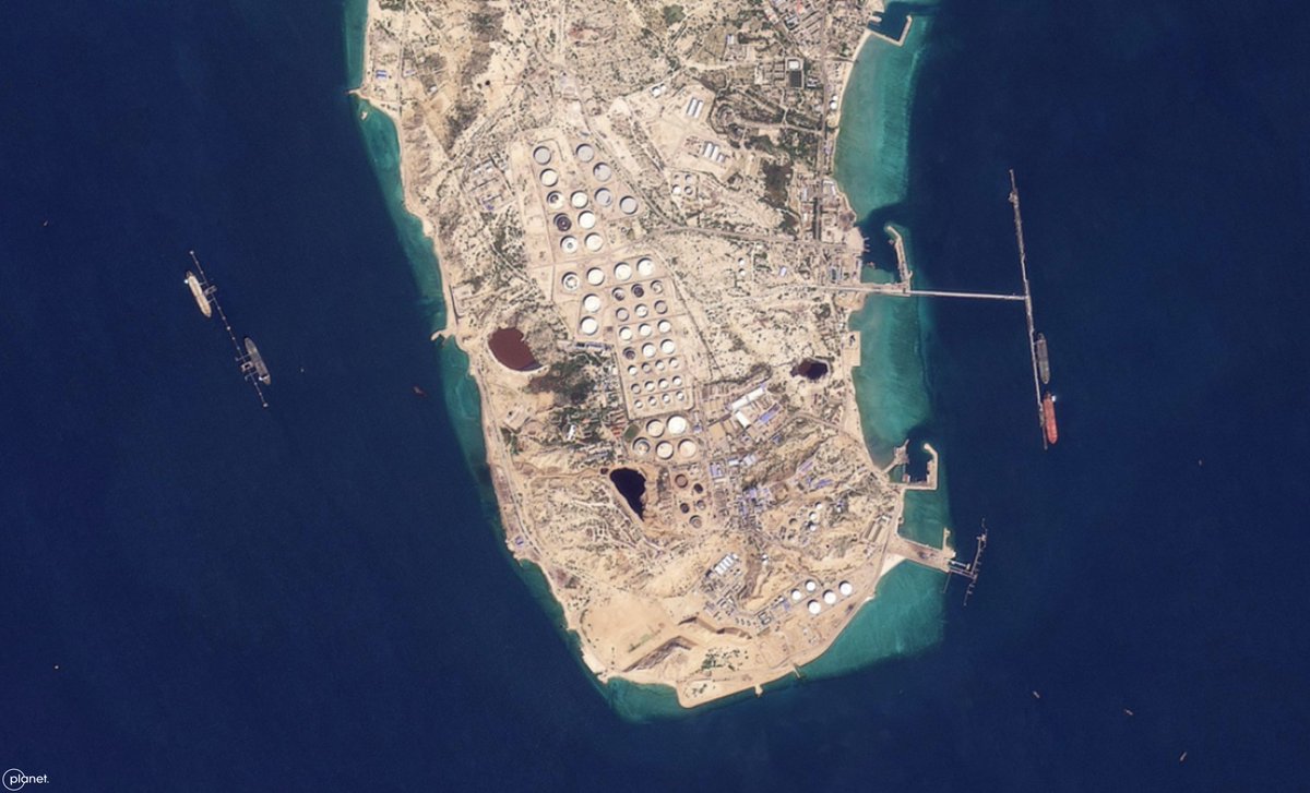
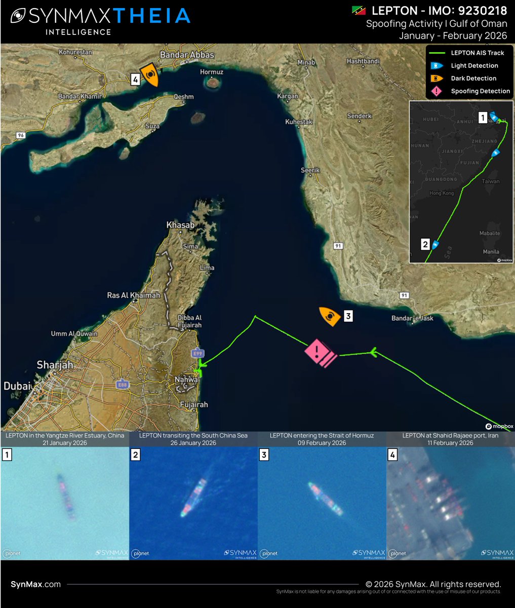
Theia, SynMax's maritime domain awareness platform, contributed satellite imagery and vessel data to the investigation. When vessels manipulate their AIS, repaint their hulls, and transit dark through contested waters, Theia analyzes vast, fused datasets to reveal the ground truth of vessel movements. We appreciate the @FT for bringing further scrutiny to the shadow fleet and the risks it poses to transparency, compliance, and maritime safety. Read the full investigation: ig.ft.com/shadow-fleet/
English
0
4
12
3.5K
SynMax Maritime
SynMax Maritime@SynMaxInt·
On the 22nd of March 2026, SynMax's maritime domain awareness platform, Theia, detected a VLCC moored at the Single Point Mooring (SPM) facility at Bandar Jask, Iran, via Sentinel-1 SAR imagery. This is the second VLCC detection at this SPM in March alone. On the 7th of March, Theia identified the OFAC-sanctioned DORE (IMO 9357717) at the same location. Situated outside the Strait of Hormuz, Bandar Jask provides Iran with a strategic loading facility that reduces exposure to chokepoint interdiction, allowing the sustained export of sanctioned Iranian crude. Theia ingests more than 30 million km² of satellite imagery daily, fusing optical and SAR data with global AIS and additional intelligence sources. Agentic AI automatically highlights suspicious events for analyst review, acting as a force multiplier that eliminates the need for random searching.
SynMax Maritime tweet media
English
0
4
6
3.2K
SynMax Maritime
SynMax Maritime@SynMaxInt·
Zombie IMO detected in the Gulf NATURE HEART operated using a zombie IMO (9251585), assigned to a reportedly scrapped vessel, while transiting the Strait of Hormuz. SynMax identified it as CORONA FUN (OFAC-designated). Satellite imagery combined with AI brings clarity when identity signals conflict.
SynMax Maritime tweet media
English
1
2
10
2.1K
SynMax Maritime
SynMax Maritime@SynMaxInt·
The BEHSHAD (IMO 9167289), later renamed MENSAR, is an Iranian cargo vessel that was operated by the Islamic Revolutionary Guard Corps (IRGC) in late 2023 and early 2024 as a forward operating base, providing Houthi forces with targeting intelligence on shipping transiting the Red Sea and the Gulf of Aden. Her predecessor, the SAFIZ (IMO 9167253), had maintained a near-permanent position in the Red Sea since 2016, providing weapons, intelligence, and logistical support to the Houthis, until she was struck by limpet mines in an Israeli-acknowledged attack. Within weeks, the BEHSHAD had sailed to take her place. SynMax's maritime domain awareness platform, Theia, tracked the BEHSHAD throughout a critical four-month period in 2024, establishing a pattern of life that correlates the vessel's position and Houthi maritime targeting effectiveness. On the 5th of January 2024, the BEHSHAD departed her longstanding position in the Red Sea, repositioning south toward the Gulf of Aden. By the 11th of January, she had taken up a loitering position approximately 70km off Djibouti. By the 13th of January, she had moved to the entrance of the Bab el-Mandeb Strait, coinciding with an uptick in Houthi attacks in the area. On the 2nd of February, following U.S. airstrikes against Iranian-backed militants across the Middle East, the BEHSHAD sought shelter in the Port of Djibouti, reportedly in response to a U.S. cyber attack. Over the 17 days she remained out of action, Houthi targeting capability was significantly degraded. She departed Djibouti on the 19th of February and, by the 12th of March, had returned to a patrolling position in the Gulf of Aden. Houthi targeting effectiveness subsequently improved. On the 4th of April at 16:48 UTC, AIS transmissions ceased to be received from the BEHSHAD- a significant behavioral abnormality. Despite this, Theia detected her AIS dark transiting the Gulf of Aden on the 6th and 8th of April. On the 18th of April, she was detected approaching Bandar Abbas, Iran. The timing of this behavioral shift is significant. Iran's large-scale strike against Israel on the 13th of April 2024, the first direct Iranian strike against Israel since 1979, involved more than 330 drones and missiles. Before launching an attack, Iran withdrew high-value and operationally exposed maritime assets. The BEHSHAD, a known vulnerability, was repositioned before the strikes were launched. Theia's persistent pattern-of-life analysis enables this kind of inference. By automatically detecting, identifying, and tracking vessels over time, Theia builds the behavioral baseline against which deviations become immediately apparent. Ingesting more than 30 million km² of satellite imagery daily, fused with global AIS and additional intelligence sources, Theia detected the BEHSHAD on multiple occasions while AIS dark, proving that even state-level actors cannot evade satellite scrutiny at scale.
English
1
0
5
447
SynMax Maritime
SynMax Maritime@SynMaxInt·
The STAR LINE (IMO 9237618) is a 23-year-old, Curaçao-flagged, 244-meter Aframax crude oil tanker, sanctioned by OFAC under her former name, MIROVA DYNAMIC. On the 21st of February, SynMax's maritime domain awareness platform, Theia, captured her entering the Strait of Hormuz. At approximately the same time, AIS transmissions ceased to be received from the vessel. On the 28th of February, she was detected at anchor in the vicinity of Bandar Abbas, Iran. AIS transmissions were received intermittently between the 28th of February and the 11th of March, though positional reliability during this period was almost certainly affected by regional electromagnetic interference (EMI). Following the 11th of March, no further AIS data was received from the vessel. On the 16th of March, Theia detected and imaged the STAR LINE alongside Kharg Island, Iran's principal crude oil export terminal. The vessel has form, having been linked to Iranian petroleum and petroleum products export activity by the U.S. Energy Information Administration (EIA). The STAR LINE's transit pattern, extended AIS dark periods, and confirmed presence at Kharg Island are consistent with established Iranian crude oil loading operations conducted by sanctioned vessels seeking to evade regulatory oversight. Theia ingests more than 30 million km² of satellite imagery daily, fusing electro-optical and SAR imagery with global AIS and additional intelligence sources. AI automatically detects, identifies, and tracks tens of thousands of vessels across oceans, regardless of AIS output, maintaining visual custody through dark and spoofing periods to provide the ground truth of vessel movements globally.
SynMax Maritime tweet media
English
0
4
14
3.1K
SynMax Maritime
SynMax Maritime@SynMaxInt·
In maritime surveillance, the biggest challenge is often not detecting suspicious behavior, but detecting it in time. AIS manipulation, illicit ship-to-ship transfers, flag changes, and ownership transfers are frequently identified only after the fact, when analysts manually review historical data. By the time the pattern becomes clear, the operational window to act may already have passed. Theia’s new automated alert capability changes that workflow. Rather than analysts continuously searching through data, the system now monitors vessel behavior and notifies them when relevant activity occurs. Users can configure alerts for any vessel globally, or for specific ships identified by name, IMO, MMSI, or an uploaded vessel list. Alerts can be triggered by a wide range of behavioral indicators, including optical detections, AIS spoofing or on/off events, ship-to-ship interactions, and flag or ownership changes. Triggers can also be combined and sequenced, allowing analysts to define the precise chain of behavior they want to monitor, reducing noise and focusing attention on genuinely suspicious activity. The result is event-driven maritime surveillance at scale: analysts receive alerts as behaviors emerge, enabling faster awareness and response. Theia ingests more than 30 million km² of satellite imagery daily, fusing electro-optical and SAR imagery with global AIS and additional datasets to automatically detect, identify, and track tens of thousands of vessels across oceans, regardless of AIS output. Alerts extend that capability into the analyst's hands, delivering the ground truth of vessel behavior.
English
0
3
6
282
SynMax Maritime
SynMax Maritime@SynMaxInt·
The XU HAI 6 (IMO 9211121) is a Chinese-flagged bulk cargo vessel. Recently, despite spoofing her AIS, SynMax's maritime domain awareness platform, Theia, tracked the vessel from Tianjin, China, to Mariel Port, Cuba, between the 26th of December 2025 and the 15th of February 2026. The vessel departed Tianjin on the 26th of December. Her crew-reported draft data suggested that she was laden with cargo, and her reported destination was Busan, South Korea, where she conducted ship-to-ship (STS) operations with tankers NO.15 DAESHIN (MMSI 440120270) and HY GWANGYANG (MMSI 440182150). Draft data analysis suggests the vessels were likely engaged in fuel bunkering. Following her departure, the XU HAI 6 reported Balboa, Panama, as her next destination. On the 2nd of February 2026, the XU HAI 6 transited through the Panama Canal, where she was observed with an additional load of containers and ISO tank containers on deck. Upon leaving the canal, the vessel updated her declared destination to Georgetown, Guyana, and began spoofing her AIS. On the 3rd of February, Theia detected her making way towards Cuba. Between the 9th and 10th of February, the XU HAI 6 was detected loitering off the northern Cuban coast before docking at Mariel Port, where she was repeatedly detected between the 11th and 15th of February. Cuba has been subject to a comprehensive U.S. embargo and sanctions package since 1962. The XU HAI 6's use of AIS spoofing to conceal her true destination and trajectory is consistent with deliberate attempts to evade regulatory scrutiny of her Cuba port call and the nature of her cargo. Theia ingests more than 30 million km² of satellite imagery daily, which is fused with global AIS and additional intelligence sources to automatically detect, identify, and track tens of thousands of vessels across oceans, regardless of their AIS output. Theia’s Agentic AI identifies suspicious patterns of behavior, documents unknown unknowns, and acts as a dramatic force multiplier, exposing bad actors and providing the ground truth of vessel movements globally.
SynMax Maritime tweet media
English
0
5
12
3.1K
SynMax Maritime
SynMax Maritime@SynMaxInt·
In our latest video, we are following on from Part 1 of our KRASNODAR (IMO 9296781) reporting (hubs.li/Q046fB9h0), in which, despite no AIS being received, SynMax's maritime domain awareness platform, Theia, tracked the 183-meter Russian-flagged bulk carrier to Sevastopol, occupied Crimea. On the 6th of September, AIS was once again received from the KRASNODAR. It was imaged as it transited through the Bosphorus on the 7th. Theia detected the vessel transiting southward through the Suez Canal on the 12th of September. She arrived at King Abdullah Economic City, Saudi Arabia, on the 16th of September, and on the 18th, Theia detected her alongside. Crew input draft height analysis confirmed cargo offloading operations took place while alongside. The KRASNODAR's pattern of behavior, AIS dark port calls at Russian-occupied Crimea followed by onward delivery to a third country, is consistent with the established mechanism by which stolen Ukrainian grain and other cargo are laundered into global supply chains. According to Ukraine's Defense Intelligence War Sanctions database, the vessel has previously been linked to the movement of grain stolen from Russian-occupied Ukrainian territory, transshipped via the port of Kavkaz in 2022. Ingesting more than 27 million km² of oceanic satellite imagery daily, Theia fuses optical and SAR imagery with AIS data to automatically detect, identify, and track tens of thousands of vessels, regardless of their AIS output. Theia rolls back time, providing evidential ground truth of vessel movements that dots on a map simply cannot replicate.
English
0
3
10
2.1K
SynMax Maritime
SynMax Maritime@SynMaxInt·
The KRASNODAR (IMO 9296781) is a 183-meter Russian-flagged bulk carrier, built in 2005, and operated by Kuban Maritime Company LLC. Previously known as RAMADA QUEEN and NEW HUNTER, the vessel has a history of involvement in the illicit movement of grain from Russian-occupied Ukrainian territory. From the 13th to the 22nd of August 2025, SynMax's maritime domain awareness platform, Theia, observed the KRASNODAR loitering in the southern Black Sea off the coast of Turkey. On the 22nd of August, while transiting north, AIS transmissions ceased to be received from the vessel. Despite this, Theia detected the KRASNODAR via optical imagery on the 23rd and 25th of August, waiting outside Sevastopol, Crimea. She was subsequently detected docked at the port of Sevastopol on the 27th and 28th of August. Crew-input draft data indicates that the vessel loaded cargo during her port call. Reception of AIS signals resumed on the 6th of September, showing the vessel transiting west through the Black Sea. Stay tuned for Part Two, in which Theia follows the KRASNODAR as she delivers her cargo. Ingesting more than 27 million km² of oceanic satellite imagery daily, Theia's advanced AI automatically identifies, attributes, and tracks tens of thousands of vessels across oceans, regardless of AIS status. Proprietary agentic agents highlight suspicious behavior, analyzing vast fused datasets to notify analysts of true unknown unknowns, with output verified by Theia's extensive imagery archives.
English
0
2
5
3.3K
SynMax Maritime
SynMax Maritime@SynMaxInt·
We are thrilled to announce that SynMax Intelligence has joined the United States Geospatial Intelligence Foundation (@USGIF) as a Strategic Partner, the highest level of organizational membership. The USGIF is a nonprofit educational foundation dedicated to promoting Geospatial Intelligence (GEOINT) tradecraft across government, industry, and academia. As a USGIF Strategic Partner, we are pleased to join a distinguished group of organizations at the forefront of the GEOINT sector, and look forward to contributing to the Foundation's mission and demonstrating the role that large-scale data fusion and cutting-edge AI can play in maritime domain awareness. We hope to see many of you at the USGIF GEOINT Symposium in May. hubs.li/Q045C3m20
English
0
2
7
1.8K
SynMax Maritime
SynMax Maritime@SynMaxInt·
We are delighted to have once again collaborated with partners @LloydsList, this time in support of their investigation into the circumvention of Ukraine's Iranian trade ban by Black Sea grain operators. The analysis, authored by @ecegoksedef and @bridget_diakun, reveals that over the past two years, at least 10 vessels have discharged Ukrainian grain in Iran, with more than half employing deceptive shipping practices to conceal their activities. SynMax's maritime domain awareness platform, Theia, provided satellite imagery central to the investigation, including the detection of the NJ EARTH (IMO 9229996) discharging at Iran's Bandar Imam Khomeini port while simultaneously broadcasting false AIS positions placing her at Sohar, Oman. While the trade itself does not breach international sanctions, the increasingly sophisticated deceptive shipping tactics deployed to obscure voyages represent a troubling adoption of shadow-fleet methodology, elevating commercial, insurance, and sanctions risk. Theia's automatic AIS spoofing detection and dark vessel attribution capabilities cut through those tactics to establish ground truth. We look forward to continuing to aid Lloyd’s List Intelligence in their quest to expose deceptive shipping practices. Read the full article here: hubs.li/Q045kWxT0
English
5
3
5
2.3K
SynMax Maritime
SynMax Maritime@SynMaxInt·
The LEPTON (IMO: 9230218) is a 25-year-old, 198-meter container vessel flagged in St. Kitts and Nevis at the time of departure. On the 19th of January 2026, the LEPTON departed Taicang, China, broadcasting Khor Fakkan, UAE as her destination. Container cargo was clearly visible on her deck. She briefly anchored in the Yangtze River Estuary, where she was detected by SynMax’s maritime domain awareness platform, Theia, on the 21st of January before she got underway on the 22nd. She was detected again transiting the South China Sea on the 26th of January. On the 9th of February, Theia determined that the LEPTON was spoofing her AIS location in the Gulf of Oman. She was simultaneously detected optically entering the Strait of Hormuz. On the 11th of February, she was identified at Shahid Rajaee Port in Bandar Abbas, Iran. Crew-entered draft data recorded a decrease from 9.5 meters to 8.2 meters during this period. On the 13th of February, the vessel ceased AIS spoofing and docked at her originally declared destination of Khor Fakkan, UAE. That same day, and at the same port, she re-flagged from St. Kitts and Nevis to Guinea-Bissau. Theia fuses more than 30 million km² of daily satellite imagery with real-time global AIS and additional datasets to automatically detect, identify, and track tens of thousands of vessels, regardless of AIS output. Agentic AI tools enable precise interrogation of vast quantities of pre-processed, auditable datasets, further multiplying the analyst’s ability to deliver high-quality intelligence to decision-makers.
SynMax Maritime tweet media
English
0
2
8
2.2K
SynMax Maritime
SynMax Maritime@SynMaxInt·
The SEVERNIY PROECT (IMO 9202053) is a Russian-flagged general cargo vessel, sanctioned by the @USTreasury and linked to Nord Project LLC Transport Company. Historically employed along the Northern Sea Route, in December 2025, she deviated from her usual pattern of life and transited south to arrive in the Black Sea on the 25th of December. Upon entering the Black Sea, AIS transmissions ceased to be received from the SEVERNIY PROECT. After 12 days of dark activity, SynMax's maritime domain awareness platform, Theia, identified the vessel docked in Sevastopol, Occupied Crimea, positioned alongside the Avlita grain terminal. By the 12th of January 2026, she had repositioned to a berth designated for heavier cargo operations, indicating potential changes in cargo activity. AIS transmissions were once again received from the SEVERNIY PROECT as she transited through the Bosphorus on the 21st of January, and continued to be received as she made her way to Syria. She arrived at Latakia, Syria's principal port, on the 25th of January, anchoring outside before docking on the 6th of February. Following the collapse of the Assad regime, Russia's strategic foothold in Syria has undergone a significant transformation, characterized by substantial withdrawals of military hardware and the termination of Russia's lease at the Port of Tartus. Yet Russia's presence has not vanished. By maintaining a minimal footprint at Tartus and expanding operations into Latakia, Russia continues to utilize Syria as a critical maritime bridge for power projection into the Mediterranean and Africa. The SEVERNIY PROJECT's delivery represents just one of many strategic shipments. Theia's ability to maintain visual custody of sanctioned vessels during AIS dark periods ensures that even state-level attempts to obscure cargo movements are documented and exposed. Theia ingests more than 30 million km² of satellite imagery daily, fusing it with global AIS and additional intelligence sources. Proprietary AI automatically detects, identifies, and tracks tens of thousands of vessels across oceans, regardless of AIS output, effectively rolling back time to reveal the ground truth of vessel movements globally.
English
0
1
4
2.8K
SynMax Maritime
SynMax Maritime@SynMaxInt·
We are thrilled to announce that Theia, SynMax's maritime domain awareness platform, has achieved "Awardable" status in the @DODCDAO @Tradewind_ai Solutions Marketplace, making the platform eligible for streamlined procurement by U.S. government customers. The designation follows a technical assessment by an independent evaluation panel, which noted that the platform "reduces analyst workload by pre-identifying high-confidence activity, enabling operators to focus on decision-making rather than search." Since 2024, Theia has processed more than 33 million vessel detections, identified over 140,000 dark vessels, and monitors more than 30 million km² of ocean daily, maintaining custody of vessels that are transmitting AIS, spoofing, or operating entirely dark. This recognition builds on $20.3 million of federal contract awards announced at the end of last year, and we look forward to continuing to actively support the U.S. defense and intelligence communities in 2026 and beyond. Read the full press release here: hubs.li/Q044CVx20
SynMax Maritime tweet media
English
0
3
3
3.9K
SynMax Maritime
SynMax Maritime@SynMaxInt·
We are excited to share that SynMax has published an in-depth analysis on @gCaptain "Sanctions, Seizures, and the Limits of Maritime Visibility." In the last six months, the US government has shown it is willing to deploy carrier strike groups to enforce sanctions. But kinetic operations of that scale require an evidentiary threshold that a satellite ping or AIS alert alone cannot meet. The article examines what building that evidence actually looks like in practice, drawing on cases documented by Theia, including the CCH GAS (IMO 9307205) and its subsequent re-emergence as the LNG SOARS, the TASCA (IMO 9313149) and its attempt to alter its visual signature through deck repainting, and the REEF (IMO 9263382) and its repeated AIS spoofing across an Iranian fuel delivery cycle to Myanmar. SynMax’s AI-powered maritime domain awareness sentinel, Theia, ingests, fuses and analyzes more than 30 million KM2 of satellite imagery every day to identify vessels regardless of their AIS output. Read the full analysis here: hubs.li/Q044sWxM0
SynMax Maritime tweet media
English
0
3
10
6.7K
SynMax Maritime
SynMax Maritime@SynMaxInt·
Spotlight Vessel #8: SEA LAUNCH COMMANDER (IMO 9133812) The SEA LAUNCH COMMANDER represents one of the most extraordinary maritime engineering achievements of the modern era, built not just to cross oceans, but to help explore space. Serving as the floating brain of the Sea Launch program, the 203-meter vessel carried engineers, satellite customers, and launch directors to the equatorial Pacific, where the Earth's rotation gives rockets a natural boost. With a 32-meter beam and 10,430-tonne deadweight capacity, the SEA LAUNCH COMMANDER housed mission control facilities, payload processing operations, crew accommodations, and the technical infrastructure required to conduct rocket launches thousands of miles from shore. Her distinctive superstructure, bristling with communications equipment and telemetry systems, transformed her into a mobile spaceport command center capable of supporting operations at sea for extended periods. Operating between 1999 and 2014, the SEA LAUNCH COMMANDER supported dozens of launches from the ODYSSEY launch platform, a converted oil-drilling vessel, and in 2013, while alongside in Long Beach, US, she served as a filming location in the Marvel film Captain America: The Winter Soldier. By ingesting and analyzing more than 30 million square kilometers of satellite imagery, SynMax’s maritime domain awareness platform, Theia, images, identifies and tracks tens of thousands of vessels every day. Which vessels would you like to see featured in our spotlight series?
English
0
1
1
1.6K