SynMax Maritime

474 posts

SynMax Maritime banner
SynMax Maritime

SynMax Maritime

@SynMaxInt

Theia by SynMax: An AI-powered sentinel for the high seas, detecting maritime deception & ensuring data transparency. @SynMaxData

Houston, TX and London, UK Katılım Nisan 2023
47 Takip Edilen1.9K Takipçiler
SynMax Maritime
SynMax Maritime@SynMaxInt·
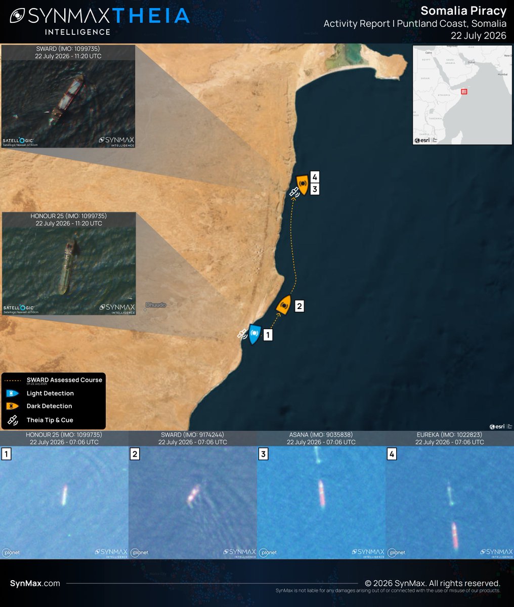
UPDATE: A fourth vessel has joined the HONOUR 25 (IMO 1099735), the SWARD (IMO 9174244), and the M/T EUREKA (IMO 1022823) under pirate control off the Puntland coast, in a continuing resurgence of Somali piracy. Find our previous reporting here: x.com/SynMaxInt/stat… The ASANA (IMO 9035838), a 127-meter, 34-year-old, Tanzanian-flagged chemical and oil products tanker, was hijacked on the 17th of July 2026 while transiting the Gulf of Aden approximately 26 nautical miles off Yemen's Hadramawt coast. Reports indicate seven armed men boarded the vessel as she sailed from Mukalla, Yemen, toward Bosaso, Somalia. Following the seizure, the ASANA altered course south before going AIS dark. On the 22nd of July, Theia detected all four vessels along the Puntland coast. HONOUR 25 remained at her established anchorage, with intermittent AIS transmissions continuing from the same position. The M/T EUREKA and ASANA were located next to one another, with no AIS data received from either vessel since the 9th of May and the 17th of July respectively. The SWARD, previously co-located with HONOUR 25, was detected approximately 18 km to the north-northeast on a heading consistent with a transit toward the positions of the EUREKA and ASANA further up the coast. No AIS data has been received from the SWARD since the 14th of June. High-resolution @Satellogic imagery, tasked using Theia's Tip & Cue capability later that day, confirmed that the SWARD had moved closer to the EUREKA and ASANA. The tight clustering of four hijacked vessels along a single stretch of coastline is consistent with organized pirate action group (PAG) activity, assessed to be taking advantage of international naval patrols stretched thin by ongoing tensions around Hormuz and the Red Sea. Theia ingests more than 40 million km² of satellite imagery daily, fusing electro-optical and SAR imagery with real-time global AIS to automatically detect, identify, and track tens of thousands of vessels, regardless of their signal output. Tip-and-cue capabilities automatically task high-resolution imagery of vessels of interest, while SynMax's Agentic AI enables the precise interrogation of vast, preprocessed datasets, massively increasing analysts' capacity and exposing true unknown unknowns.
SynMax Maritime tweet media
SynMax Maritime@SynMaxInt

Between the 21st of April and the 2nd of May 2026, three commercial vessels were hijacked off the coast of Somalia and Yemen in a significant resurgence of Somali piracy, assessed to be highly likely carried out by Somali pirate action groups (PAGs) operating from the Puntland coast. The HONOUR 25 (IMO 1099735), the SWARD (IMO 9174244), and the M/T EUREKA (IMO 1022823) remain under pirate control. SynMax's maritime domain awareness platform, Theia, has tracked the vessels throughout their ordeals, detecting each off the Puntland coast as recently as the 28th of May. The HONOUR 25 (IMO 1099735) is a Palau-registered product tanker. She was seized on the 21st of April while en route from Berbera, Somaliland, to Mogadishu, while laden with refined oil. Theia detected her on the 28th of May, anchored off the Puntland coast south of Bayla. On the 26th of April, the SWARD (IMO 9174244), a 100-meter general cargo ship built in 1998 and flagged in St. Kitts and Nevis, was hijacked approximately six nautical miles northeast of Garacad, Somalia. At the time, she was reportedly transiting to Mombasa with a cargo of cement. Theia imaged her on the 28th of May in the vicinity of Dhingwda, approximately 200km south of the other two vessels. The M/T EUREKA (IMO 1022823) is an 88-meter, Togo-flagged product tanker, built in 2006. She was seized off Yemen's Shabwa coast on the 2nd of May while transporting diesel from the UAE. Continuous tracking and the ability to dynamically tip-and-cue high-resolution imagery enabled the tasking of @Satellogic imagery of the M/T EUREKA on the 23rd of May, confirming her position in the vicinity of Bayla. The geographic spread of the three vessels along the Puntland coastline is consistent with established patterns of Somali piracy. It is believed that organized crime groups in Somalia are taking advantage of the Iran war to launch hijackings, as international naval patrols, first deployed in 2008 to counter the pirates, have been stretched thin by current events around Hormuz and the Red Sea. Theia ingests more than 40 million km² of satellite imagery daily, fusing electro-optical and SAR imagery with real-time global AIS to automatically detect, identify, and track tens of thousands of vessels, regardless of their signal output. Tip-and-cue capabilities automatically task high-resolution imagery of vessels of interest, while SynMax's Agentic AI enables the precise interrogation of vast, preprocessed datasets, massively increasing analysts' capacity and exposing true unknown unknowns.

English
0
2
5
5.2K
SynMax Maritime
SynMax Maritime@SynMaxInt·
We are very pleased to have once again collaborated with @gCaptain on their follow-up analysis of Russia's Arctic LNG 2 project at Novatek's Belokamenka yard, Murmansk. Theia automatically analyzes more than 40 million km² of satellite imagery daily, to provide the ground truth necessary to monitor sanctioned activity. @malte_humpert
gCaptain@gCaptain

Arctic LNG 2 Train 3 Modules Offloaded at Novatek Yard, but Satellite Images Show Construction Still Largely Idle gcaptain.com/arctic-lng-2-m…

English
0
4
14
1.8K
SynMax Maritime
SynMax Maritime@SynMaxInt·
The CAROLINE BEZENGI (IMO 9224439) is a 25-year-old, 274-meter Suezmax crude oil tanker sanctioned by the EU, UK, Switzerland, Ukraine, and Canada. Public sanctions listings cite the vessel's involvement in transporting Russian oil above the G7 price cap, as well as links to Sovcomflot, Russia's state-owned shipping company. Imagery collected by SynMax on the 10th of May 2026 confirms the CAROLINE BEZENGI was alongside at Novorossiysk, Russia. Crew-entered draft data subsequently increased, strongly suggesting cargo loading activity prior to commencing her most recent voyage. The vessel reportedly first experienced difficulties on the 8th June off Mukalla, Yemen, and AIS transmissions ceased on the 10th. The cause remains unconfirmed. On the 20th of July, SynMax's maritime domain awareness platform, Theia, tasked 50 cm @Satellogic imagery, which confirmed the CAROLINE BEZENGI aground on the westernmost point of Al-Qibliyah Island, Oman, more than five weeks after AIS transmissions ceased. The vessel's stern appears partially submerged, and a feature consistent with an oil slick appears to extend from her port side.  Al-Qibliyah Island is one of five islands comprising the Al Hallaniyat Archipelago, off Oman's Dhofar coast. The archipelago lies within a protected maritime reserve established to conserve the area's marine biodiversity. It supports rare coral reef habitats, provides nesting grounds for several sea turtle species, and serves as an important stopover for migratory birds, increasing the potential environmental impact of any confirmed oil release. Theia ingests more than 40 million km² of satellite imagery each day, fusing it with global AIS and additional intelligence sources to automatically detect, identify, and track vessels worldwide, including those no longer transmitting AIS. In cases such as the CAROLINE BEZENGI, where a sanctioned vessel disappears from public tracking for weeks, Theia enables analysts to establish a vessel's location and condition independently of its AIS transmissions, providing timely, evidence-based maritime domain awareness.
SynMax Maritime tweet media
English
1
13
51
36.3K
SynMax Maritime
SynMax Maritime@SynMaxInt·
We are very happy to see SynMax's data featured in @malte_humpert's latest analysis on Russia's Arctic LNG 2 project. Satellite imagery shared with @gCaptain shows two sanctioned heavy-lift vessels delivering key modules to Novatek's Belokamenka construction yard near Murmansk, the clearest indication yet that work on the project's long-stalled third production train could be resuming. Theia, SynMax's maritime domain awareness platform, ingests more than 40 million km² of satellite imagery daily, fusing it with global AIS data to detect, identify, and track vessels globally, regardless of AIS output or compliance status.
Malte Humpert@malte_humpert

🇷🇺🏗️Sanctioned Heavy-Lift Ships Deliver Key Arctic LNG 2 Modules to Russia, Pointing to Construction Restart Heavy-lift vessel Glory Ocean and Bright Ocean berthed at Novatek’s Belokamenka facility near Murmansk. gcaptain.com/sanctioned-hea…

English
0
5
12
5.8K
SynMax Maritime
SynMax Maritime@SynMaxInt·
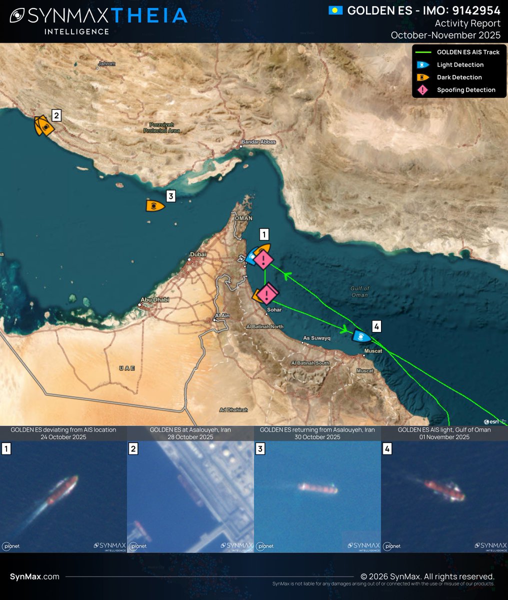
In the first of a four-part series on AIS spoofing, we start with the fundamentals: what the Automatic Identification System (AIS) is, where its trust breaks down, and why that matters to anyone who relies on it. AIS was originally designed to prevent ship collisions. It was never intended to be a trusted record of vessel movements, a distinction that poses a significant challenge for those relying solely on AIS to create an accurate picture of the maritime environment. The maritime world's self-reporting location transponder, vessels broadcast AIS signals continuously over VHF radio, transmitting identity, position, course, speed, and type to other ships, coastal stations, and satellites. AIS was mandated under the SOLAS convention for vessels of 300 gross tons or more and for all passenger ships, regardless of size. Accountability within the system is a structural flaw. AIS is neither encrypted nor authenticated, and nothing verifies that a transmission is true. A vessel can broadcast almost any identity and any position it chooses, and without evidence to the contrary, the maritime community accepts it. AIS spoofing is the deliberate exploitation of that trust. It is not a glitch or a coverage gap. It is false information transmitted by design: a fabricated position, a stolen identity, a substituted flag, or, in some cases, a ship that does not exist at all. The consequence reaches well beyond a single bridge. Regulators, insurers, and navies frequently treat AIS as ground truth, so when the signal lies, the intelligence picture lies with it. In October 2025, the Palau-flagged cargo vessel GOLDEN ES (IMO 9142954) transmitted an AIS-reported track in October 2025 consistent with a voyage between Fujairah, UAE, and Sohar, Oman. Satellite and optical detections during the same period placed the vessel instead at Asalouyeh Port, Iran, where she was observed alongside and engaged in loading activity, a position inconsistent with the AIS-reported track. The signal placed her in one location; the imagery established another. AIS reports what a vessel volunteers, not what is true, and a position on a screen is never evidence in and of itself. Closing that gap is the discipline of maritime domain awareness, and the problem SynMax's maritime domain awareness platform, Theia, was built to resolve. Fusing more than 40 million km² of daily satellite imagery with global AIS and more, Theia measures what a vessel claims against what the imagery shows, establishing the verified ground truth a signal alone cannot provide.
SynMax Maritime tweet media
English
0
1
8
3.6K
SynMax Maritime
SynMax Maritime@SynMaxInt·
SynMax will be at the Maritime Security Summit at National Harbor, July 15-16. Maritime domain awareness, dark-vessel detection, verification that doesn't rely on a vessel cooperating. The work Theia does. Find our team on the floor and at the receptions.
SynMax Maritime tweet media
English
0
2
5
1.6K
SynMax Maritime
SynMax Maritime@SynMaxInt·
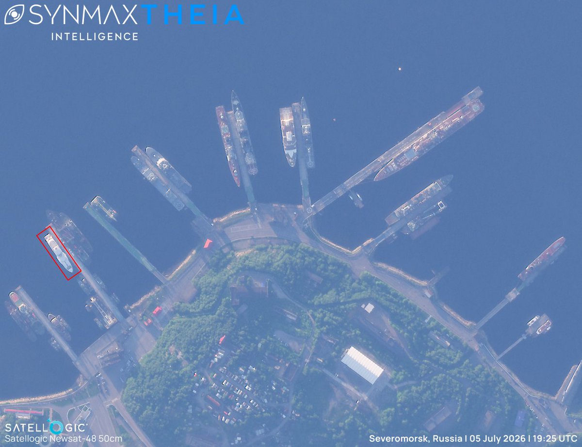
The KOSATKA (IMO 1011551), a 82-metre superyacht formerly known as GRACEFUL and widely linked to Vladimir Putin, has arrived at Severomorsk, Russia, on the Kola Peninsula, following a voyage north from the Baltic under naval escort by the destroyer SEVEROMORSK and patrol vessel VOEVODA. Sanctioned by the United States in 2022 and renamed shortly afterward, the KOSATKA had not transmitted on AIS since August 2022, before briefly reappearing in late June 2026. The relocation follows a pattern of Russian-linked superyachts moving away from Baltic and Black Sea anchorages in recent weeks, amid concern over the reach of Ukrainian long-range drones. SynMax's maritime domain awareness platform, Theia, detected the KOSATKA alongside in Severomorsk (red outline), near a cluster of naval and support vessels, enabling the tip-and-cue of @Satellogic high-resolution imagery. Theia fuses more than 40 million km² of daily satellite imagery with global AIS and additional intelligence sources to automatically detect, identify, and track tens of thousands of vessels across oceans, regardless of AIS status. Theia's Agentic AI, Atlas, can be configured to alert analysts the moment a vessel of interest becomes active again, whether through a resumed AIS transmission or a fresh detection, ensuring no reappearance goes unnoticed, regardless of how long a vessel has been dark.
SynMax Maritime tweet media
English
0
3
19
5.1K
SynMax Maritime
SynMax Maritime@SynMaxInt·
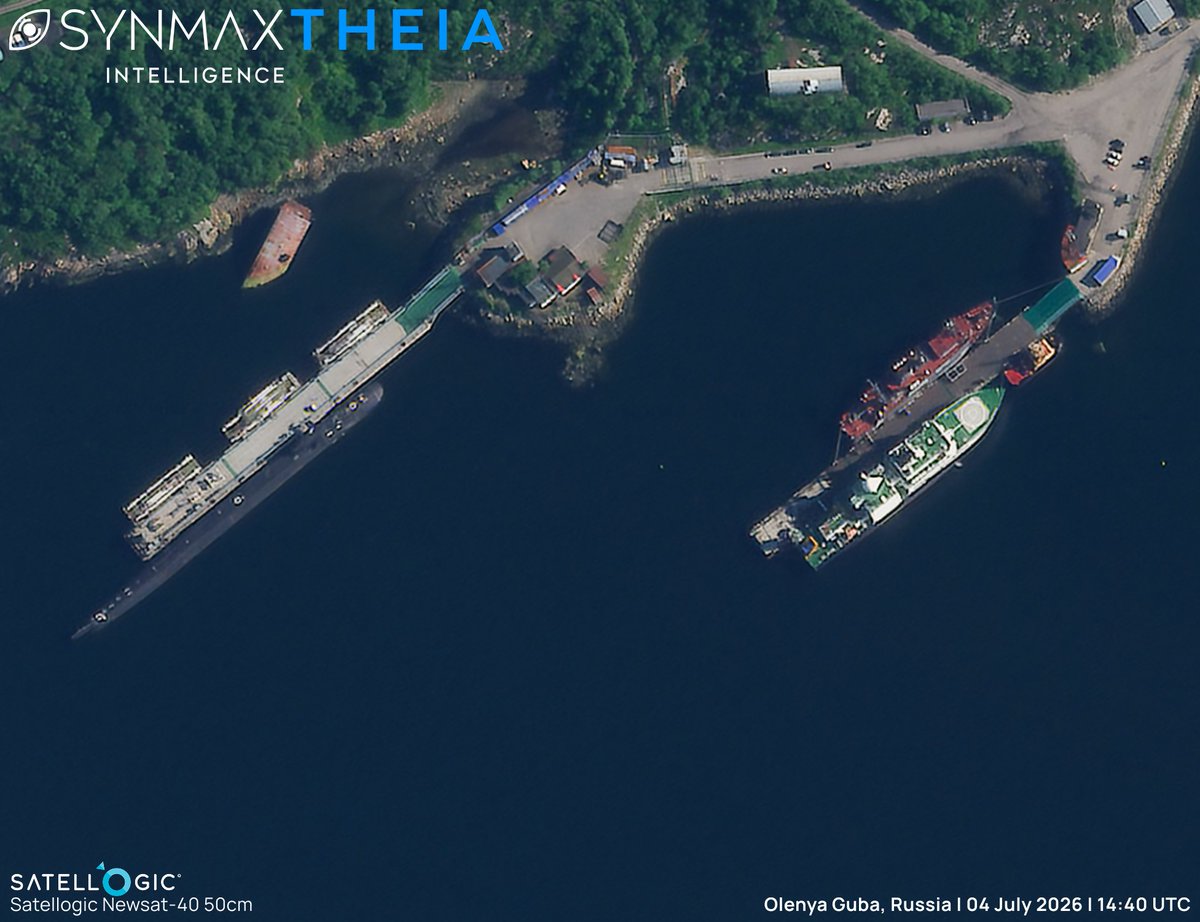
Following our recent reporting on the YANTAR (IMO 7524419), the Russian intelligence collection ship that was tracked AIS dark in the Barents Sea on the 26th of June (x.com/SynMaxInt/stat…), SynMax's maritime domain awareness platform, Theia, located the vessel AIS dark at her home base. On the 4th of July 2026, Theia tasked high-resolution Satellogic imagery of the YANTAR at Olenya Guba, on the Kola Peninsula- the base of Russia's Main Directorate of Deep Sea Research (GUGI), home to its special-purpose vessels, including the YANTAR. This sequence demonstrates Theia's tip-and-cue capability. Wide-area detection of the AIS-dark YANTAR in the Barents Sea prompted tasking of high-resolution imagery, delivering a detailed picture of one of Russia's most sensitive naval facilities. Automatically analyzing more than 40 million km² of satellite imagery daily, Theia fuses electro-optical and synthetic aperture radar (SAR) imagery with global AIS to detect, identify, and track tens of thousands of vessels, regardless of AIS status. By establishing a pattern of life for strategic vessels such as the YANTAR and cueing high-resolution collection against it, Theia provides decision-makers with early warning and evidential ground truth. Building on this, SynMax's Agentic AI, Atlas, autonomously interrogates these vast fused datasets to surface significant behaviors.
SynMax Maritime tweet media
SynMax Maritime@SynMaxInt

The YANTAR (IMO 7524419) is a 108-meter intelligence collection ship. Officially classed as an oceanographic research vessel, she is attached to the Northern Fleet and operated by Russia's Main Directorate of Deep Sea Research (GUGI). Western governments, including the United Kingdom and Norway, have assessed that the YANTAR is used to map and, potentially, to prepare to disrupt critical undersea cables and seabed infrastructure. Historically, the YANTAR has routinely operated with her AIS switched off, placing the vessel beyond conventional tracking. Despite this, SynMax's maritime domain awareness platform, Theia, routinely tracks her movements, including last week in the Barents Sea. On the 20th and 22nd of June 2026, Theia imaged the YANTAR in port. On the 26th of June, she was detected and identified loitering off the Kola Peninsula. No AIS signals were received during this period.  By establishing a pattern of life for strategic vessels such as the YANTAR, Theia ensures that any deviation stands out immediately, offering decision-makers early warning of a potential deployment. Automatically analyzing more than 40 million km² of satellite imagery daily, Theia fuses electro-optical and synthetic aperture radar (SAR) imagery with global AIS to detect, identify, and track tens of thousands of vessels, regardless of AIS status. Building on this, SynMax's Agentic AI autonomously interrogates these vast fused datasets to expose significant behaviors as they occur.

English
0
4
26
5.1K
SynMax Maritime
SynMax Maritime@SynMaxInt·
We'll be at the Esri User Conference in San Diego, July 13–17, with members on the floor all week talking geospatial intelligence, from maritime to energy infrastructure. If you're building on GIS and want to compare notes, DM us and we'll find time.
SynMax Maritime tweet media
English
0
1
2
268
SynMax Maritime
SynMax Maritime@SynMaxInt·
Happy Fourth of July from the SynMax team. 🇺🇸
English
0
1
3
2.2K
SynMax Maritime retweetledi
Eric Anderson
Eric Anderson@ericworksalot·
I saw this first as a quant: there was never a shortage of data, just no way to turn the flood into a decision. That problem is why we built Theia Agents. Nice to see @Forbes covering how our AI is finally unmasking the shadow fleet. bit.ly/4oTw0py
English
0
2
4
276
SynMax Maritime
SynMax Maritime@SynMaxInt·
Fishing fleets can spoof their positions, but the tankers resupplying them have to keep AIS on so the fleet can find them. That's the weak point. Sen. Ted Cruz, at the opening of SynMax's DC Maritime Intelligence Center, put it at 55 tankers behind nearly half of 2024's trans-shipment events. Few enough to sanction. SynMax CEO Eric Anderson: "More commonly they spoof their location." Theia surfaces the behavior anyway. forbes.com/sites/zitaball…
English
0
4
7
1.9K
SynMax Maritime retweetledi
WACB
WACB@wacbinvesting·
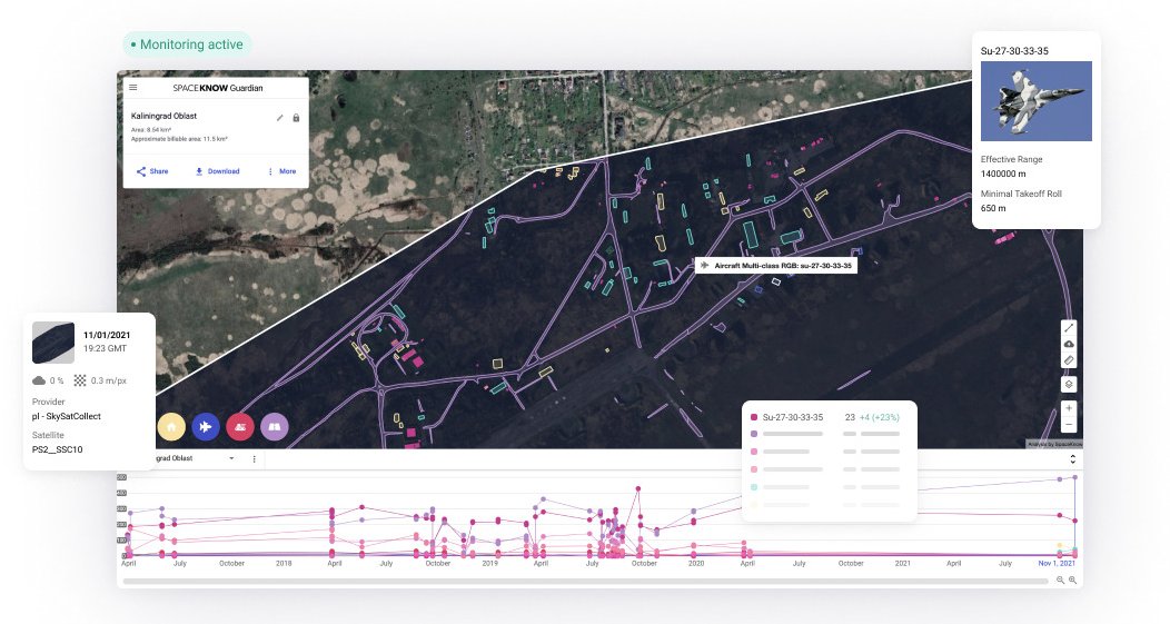
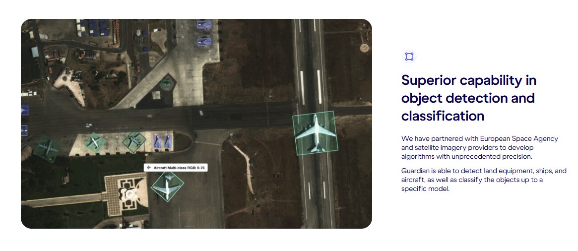
$SATL Satellogic and SpaceKnow Partner to Extend Persistent Global Intelligence Across Commercial and Government Markets - investors.satellogic.com/news-releases/… This is the second key partnership @Satellogic has formed within the last week adding @spaceknow and @SynMaxInt forming a select group of "early partners in Satellogic's emerging agentic intelligence ecosystem". This is the first time I've heard the company refer to there next "Agentic Intelligence System" which could be the next extension of the Aleph Observer. Interested to get your takes @loco_dela_bolsa @gmpnavi My read is that the Merlin constellation is the key draw here. A scalable, low-cost, high-revisit infrastructure layer is exactly what enables third-party developers to build persistent analytics on top something that has historically been constrained by cost and access to imagery The PGI Infrastructure that the partnership is bult on "enables a seamless, end-to-end intelligence loop through the combination of the infrastructure — satellites, imagery, and native analytics capabilities from Satellogic — as well as interoperable agents and analytics capabilities delivered through partners, like SpaceKnow" Key Quote “Working with Satellogic gives us access to one of the most ambitious Persistent Global Intelligence infrastructures being built today, For more than a decade, our customers have been constrained by the cost and frequency of the underlying imagery. Satellogic’s economics and the upcoming Merlin constellation change that calculus, allowing us bring continuous, decision-ready monitoring, such as pattern-of-life analysis and anomalous event detection, to use cases that were previously out of reach said Jerry Javornicky, CEO and Co-Founder of SpaceKnow. Spaceknow Operates across two key markets that overlap with @Satellogic. Defense & Intelligence is their main market but they are also players in the Construction monitoring market as well. There product is called Guardian and is a advanced analytical platform that detects shifts, updates, or developments as they happen in real time. This seems like the Aleph observer on steroids. This is something @spaceknow has been doing for a while as I was able to find a case study dating back to 2018 about there help fighting ISIS forces in Iraq - spaceknow.com/case-studies/t… Lastly, to me the strategic takeaway is that Satellogic is not trying to build the entire analytics stack in-house. Instead, they appear to be positioning themselves as the infrastructure + platform layer, while pulling in specialized partners to build application-specific intelligence on top. If that framing is correct, this starts to look less like a satellite company and more like an emerging geospatial intelligence platform Attached below are some screenshots of @spaceknow product stack. Let me know your thoughts
WACB tweet mediaWACB tweet mediaWACB tweet mediaWACB tweet media
English
1
6
38
1.8K
SynMax Maritime
SynMax Maritime@SynMaxInt·
The YANTAR (IMO 7524419) is a 108-meter intelligence collection ship. Officially classed as an oceanographic research vessel, she is attached to the Northern Fleet and operated by Russia's Main Directorate of Deep Sea Research (GUGI). Western governments, including the United Kingdom and Norway, have assessed that the YANTAR is used to map and, potentially, to prepare to disrupt critical undersea cables and seabed infrastructure. Historically, the YANTAR has routinely operated with her AIS switched off, placing the vessel beyond conventional tracking. Despite this, SynMax's maritime domain awareness platform, Theia, routinely tracks her movements, including last week in the Barents Sea. On the 20th and 22nd of June 2026, Theia imaged the YANTAR in port. On the 26th of June, she was detected and identified loitering off the Kola Peninsula. No AIS signals were received during this period.  By establishing a pattern of life for strategic vessels such as the YANTAR, Theia ensures that any deviation stands out immediately, offering decision-makers early warning of a potential deployment. Automatically analyzing more than 40 million km² of satellite imagery daily, Theia fuses electro-optical and synthetic aperture radar (SAR) imagery with global AIS to detect, identify, and track tens of thousands of vessels, regardless of AIS status. Building on this, SynMax's Agentic AI autonomously interrogates these vast fused datasets to expose significant behaviors as they occur.
SynMax Maritime tweet media
English
0
4
9
6.3K
SynMax Maritime
SynMax Maritime@SynMaxInt·
MDA comes to DC. SynMax opened its Washington, D.C. office last night. @SenTedCruz and @DanCrenshawTX joined us at the reception, alongside policymakers, customers, and partners from across the defense and intelligence communities. Thank you to everyone who came out.
SynMax Maritime tweet mediaSynMax Maritime tweet mediaSynMax Maritime tweet media
English
0
1
1
302
SynMax Maritime
SynMax Maritime@SynMaxInt·
Over land, the hard part is knowing where to look. Most collection assumes you already do. Satellogic delivers the coverage. SynMax fuses it and surfaces the threats no one thought to task. SpaceNews on the SynMax and Satellogic partnership. spacenews.com/satellogic-par…
English
0
0
4
4.6K
SynMax Maritime
SynMax Maritime@SynMaxInt·
We’re very happy to share that SynMax CEO @ericworksalot has published a new analysis, "The New Intelligence Model to Combat Shadow Fleets," in Ocean Economy. The piece confronts the deception that now defines the shadow fleet: AIS spoofing. Where switching off AIS once signalled that something was being hidden, a falsified track conceals the fact that anything is being hidden at all. For the governments, insurers, ports, and traders relying on those feeds, the fabricated position is where the risk sits. Eric's argument is that the answer is not more data, but better analysis: a ladder of questions in which each layer multiplies the value of the one beneath, and using agentic AI as a tool to investigate rather than simply flag, with final judgment belonging to a person. This is the model Theia was built around. Automatically analyzing more than 40 million km² of satellite imagery daily and fusing it with global AIS, SAR, and more, Theia establishes the behavioral baselines and surfaces the anomalies described in the piece, while SynMax's Agentic AI does the investigative legwork, turning millions of detections into substantiated leads.  Read the full article here: oceaneconomy.news/2026/06/22/the…
English
0
2
6
2K
SynMax Maritime
SynMax Maritime@SynMaxInt·
@SpaceNews_Inc  on a new maritime intelligence initiative, organized by @USGIF and led by SynMax. Our CEO Eric Anderson on the top frustration government customers report: "platform overload" — analysts juggling multiple proprietary systems to reach the best intelligence. The fix the group is after is standardization. spacenews.com/geospatial-ind…
English
0
1
4
121
SynMax Maritime
SynMax Maritime@SynMaxInt·
The ADMIRAL NAKHIMOV is a Russian Kirov-class nuclear-powered heavy battlecruiser, and at 251 meters, is one of the largest surface combatants in the world. On the 14th of June 2026, SynMax's maritime domain awareness platform, Theia, detected the warship operating in the White Sea during what is reported to be the final phase of her sea trials. Commissioned in 1988 and last operational in 1997, the vessel has spent much of the intervening period laid up at the Sevmash shipyard in Severodvinsk, Russia, undergoing a modernization programme. She departed from Severodvinsk in late May 2026, reportedly with the goal of returning to service with Russia's Northern Fleet. Although no AIS signals were received from the vessel, Theia consistently detected her throughout the trial programme. Theia ingests more than 40 million km² of satellite imagery daily, fusing electro-optical and synthetic aperture radar (SAR) imagery with global AIS to automatically detect, identify, and track tens of thousands of vessels, regardless of AIS output. Monitoring strategic assets such as the ADMIRAL NAKHIMOV daily establishes a clear pattern of life against which any change in activity stands out, providing early warning to decision-makers.
SynMax Maritime tweet media
English
2
2
8
2K