@ketan963895656 @TWLCommunity24 Tomorrow nse is closed
Now on monday
English
Prit Patel
782 posts


#Gujarat outlook 24-27 Oct SW Monsoon 2.0 like weather ⛈️ Max temps dropping to pleasant 28-30°C by Sunday. Clouding over on Friday as Depression inches closer. Scattered thundershower activity over south Gujarat tonight. A trough extending from the Depression across #Saurashtra will significantly enhance thunderstorms and #GujaratRains activity across most of state from 25th Parts of south Gujarat and south+east Saurashtra like Surat, Valsad, Bharuch, Bhavnagar, Ahmedabad, Botad, Amreli, Gir, Junagadh, Rajkot, Porbandar will see rounds of mod-heavy rains and thunderstorms on Saturday to Monday. These areas can see accumulation of 100-200 mm🌧️ Even rest of north and central Gujarat, north Saurashtra can see about 50-80mm accumulations. Kutch to see isolated thunderstorm activity

Very very interesting days ahead! Potentially an extremely rare event unfolding?! A fresh LPA to form over SW Bay of Bengal on Tuesday 21st. To move NW towards #Chennai and south AP coast, while steadily consolidating into Depression. To cross peninsular India heading towards Maharashtra by 23rd October. Simultaneously, a digging #WesternDisturbance trough will lead to collapse of the STR over north Bay. At the same time, an MJO+ER coupled Westerly wind burst will trigger strong southwesterlies. Additionally, a ridge will build over Maldives region. All the above occurences will result in pulling the ITCZ very unusually northwards, followed by Monsoon like SW'lies bringing boatloads of moisture towards #Konkan and western Maharashtra. To add to this, remnants of Depression that will come from Chennai, across peninsular Bharat could also re-emerge off Raigad coast enhancing 🌧️⛈️ TL;DR If this aligns as I'm expecting it to, then rounds of heavy #Monsoon like rainfall/thunderstorms likely across most of the region (including Mumbai) just after Diwali between 23-29 October 🌧️ Will update as we get closer 😃

#Depression 92A and 93B Update 2 92A over south #ArabianSea moved northwards over last 24 hrs, currently lies about 500km west of #Kavaratti #Lakshadweep. To move NNE closer to the coast while steadily consolidating in next 48hrs. 93B grazing the TN coast south of #Chennai, to cross Peninsula rapidly overnight and merge with 92A by Thursday morning.

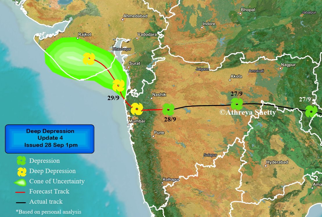


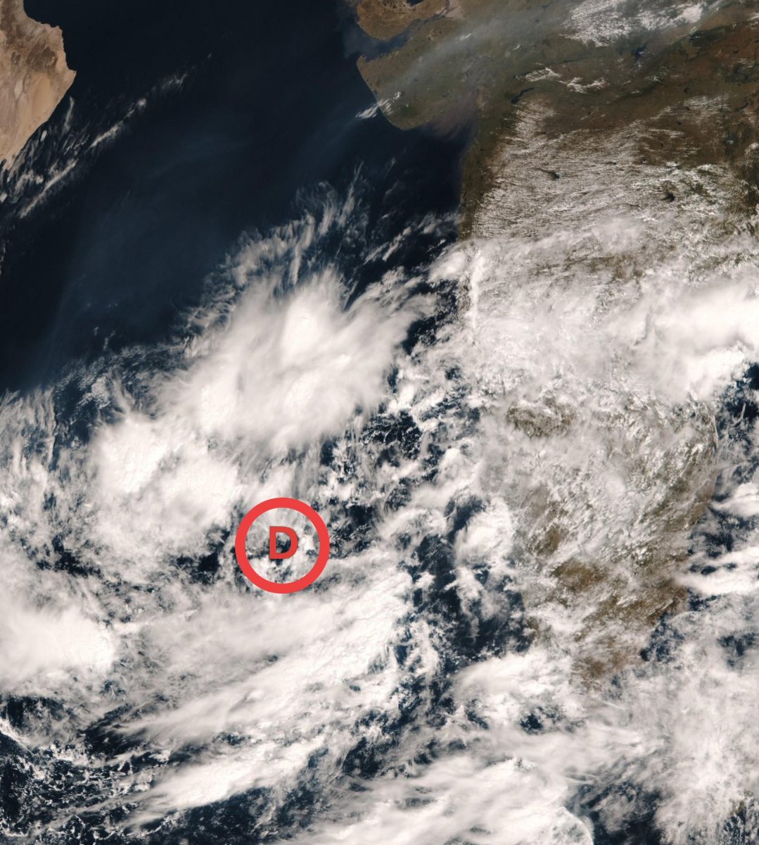
#DeepDepression Update 3🌀 Depression merged with remnants of Ragasa, crossed AP adjoining South Odisha coast overnight moving WNW. Currently lies over #Gadchiroli in #Vidarbha region, will continue to track nearly westwards, maintaining its intensity for next 24hrs. To intensify into a Deep Depression once it taps into moisture feed from #ArabianSea by Sunday evening around Ahilyanagar, tracking towards #Mumbai and north #Konkan.
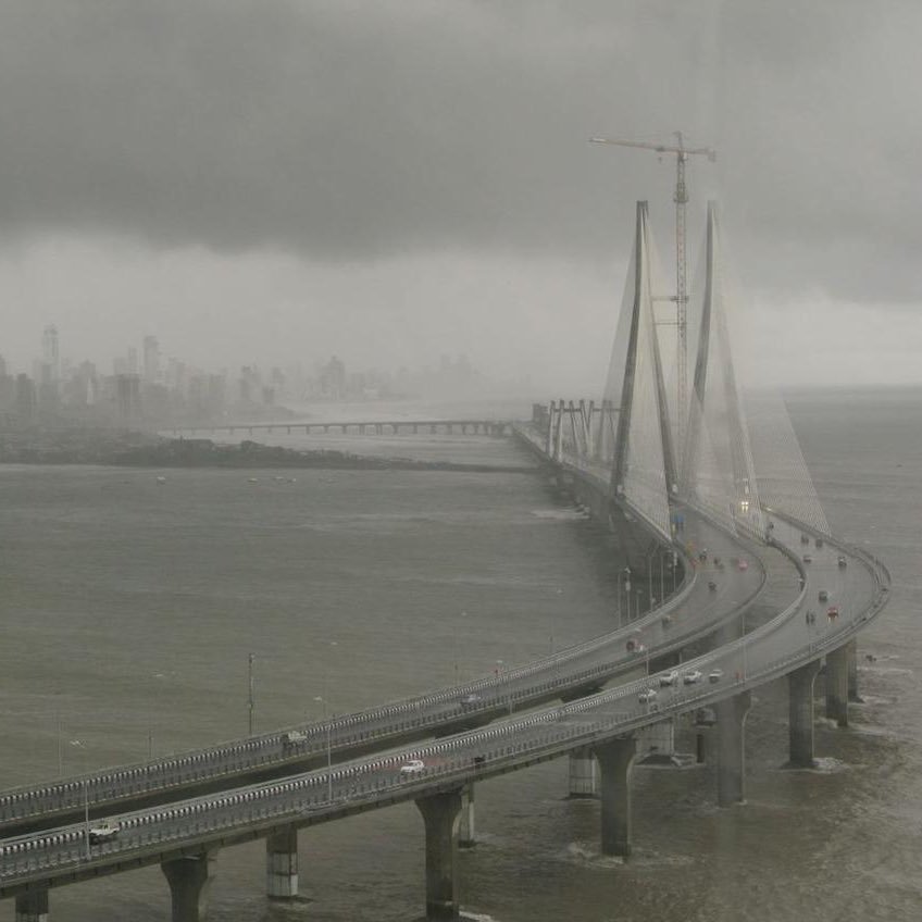
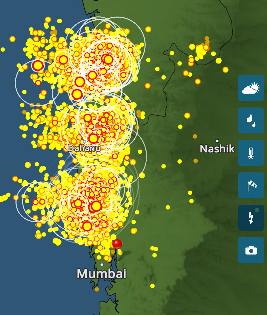
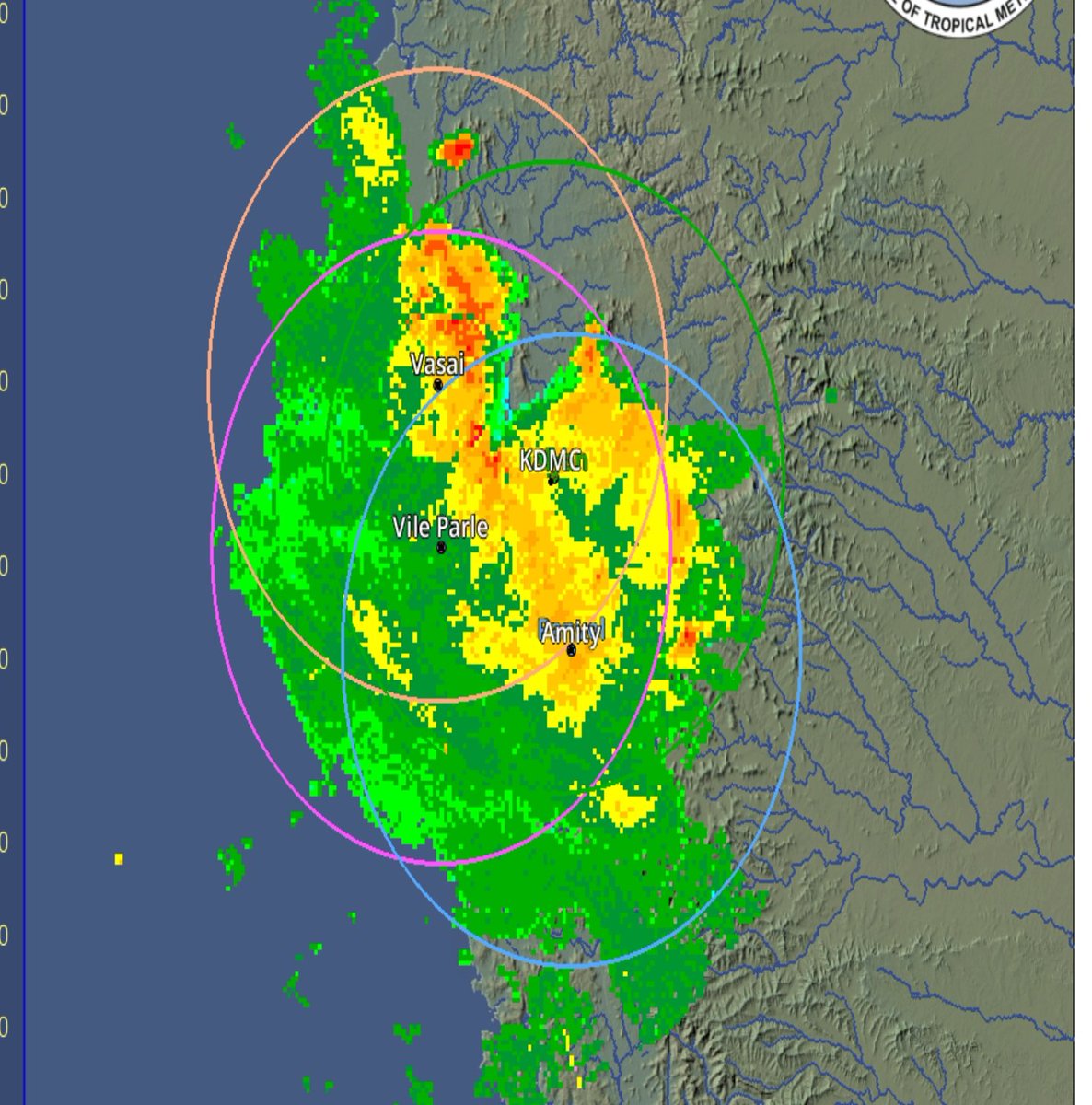
#Konkan, #Mumbai MMR and ghats outlook 27-29 Sep ⚠️🌧️🌊 As mentioned a week ago, negative IOD induced extreme spell of #Monsoon2025 will batter the region! Vortex of the Deep Depression to station itself over Thane/Palghar region, dumping huge amounts. 27 Sep - Amber warning 🟠 post noon for north konkan for heavy #MumbaiRains, initially with some thunderstorms. Local intense spells can cause minor impacts & waterlogging. About 60-120mm on average. 28 & 29 Sep - Red warning 🔴 for Mumbai, suburbs, #NaviMumbai #Thane, #KDMC, #Raigad #Palghar for very-extremely heavy downpours! These 2 days will be very similar to the deluge of 18-19 August, initially starting from south MMR moving northwards with vortex. 200mm+ rainfall expected widely, with isolated regions in south and west MMR likely to see around 300 mm in 24 hrs! Over these 72hrs can expect about 400-500mm of rainfall in MMR, leading to flooding in vulnerable spots of the city and surge in river levels with severe disruption. Avoid travel on Sunday and Monday ⚠️ Red warnings for north Ratnagiri 🔴 on 28-29th for very-extremely heavy rains. Amber warnings for South Ratnagiri and Sindhudurg 🟠for heavy- very heavy rains. Red warning 🔴 for #ghats of Pune, Satara and Nashik for extremely heavy rains with few exceptionally heavy downpours. Strictly avoid ghat travel on Sunday and Monday. These 48hrs likely to see severe weather with 500-600 mm! If needed, warnings will be updated based on real time movement of system.
#Konkan, #Mumbai MMR and ghats outlook 27-29 Sep ⚠️🌧️🌊 As mentioned a week ago, negative IOD induced extreme spell of #Monsoon2025 will batter the region! Vortex of the Deep Depression to station itself over Thane/Palghar region, dumping huge amounts. 27 Sep - Amber warning 🟠 post noon for north konkan for heavy #MumbaiRains, initially with some thunderstorms. Local intense spells can cause minor impacts & waterlogging. About 60-120mm on average. 28 & 29 Sep - Red warning 🔴 for Mumbai, suburbs, #NaviMumbai #Thane, #KDMC, #Raigad #Palghar for very-extremely heavy downpours! These 2 days will be very similar to the deluge of 18-19 August, initially starting from south MMR moving northwards with vortex. 200mm+ rainfall expected widely, with isolated regions in south and west MMR likely to see around 300 mm in 24 hrs! Over these 72hrs can expect about 400-500mm of rainfall in MMR, leading to flooding in vulnerable spots of the city and surge in river levels with severe disruption. Avoid travel on Sunday and Monday ⚠️ Red warnings for north Ratnagiri 🔴 on 28-29th for very-extremely heavy rains. Amber warnings for South Ratnagiri and Sindhudurg 🟠for heavy- very heavy rains. Red warning 🔴 for #ghats of Pune, Satara and Nashik for extremely heavy rains with few exceptionally heavy downpours. Strictly avoid ghat travel on Sunday and Monday. These 48hrs likely to see severe weather with 500-600 mm! If needed, warnings will be updated based on real time movement of system.