Justin Buchinsky

2.8K posts

Justin Buchinsky banner
Justin Buchinsky

Justin Buchinsky

@JBuchinskyWX

Meteorologist (MSc Student @LMU_Muenchen). Former Wildfire Met @ San Diego. Covering Severe Weather & Wildfire. 🇺🇸 ➡️ 🇩🇪 | Tweets in 🇬🇧

Munich, Bavaria Beigetreten Mayıs 2016
340 Folgt1.7K Follower
Angehefteter Tweet
Justin Buchinsky
Justin Buchinsky@JBuchinskyWX·
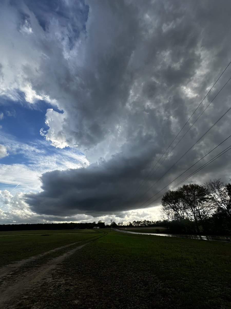
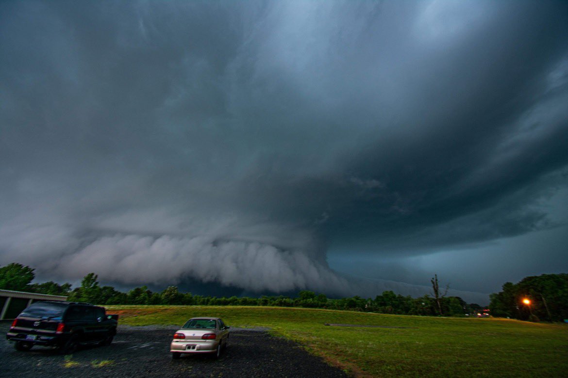
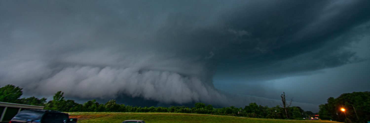
DSLR shot of yesterdays tornadic supercell that impacted #Wentworth, NC. Time~ 7:45pm. #ncwx
Justin Buchinsky tweet media
Blacksburg, VA 🇺🇸 English
21
157
1.1K
0
Justin Buchinsky
Justin Buchinsky@JBuchinskyWX·
@sambrandt99 Found this from a satellite lecture I had last semester. It represents your tweet very well. Satellite data is king for model performance.
Justin Buchinsky tweet media
English
0
0
1
74
Sam Brandt
Sam Brandt@sambrandt99·
A reduction in balloon launches definitely doesn’t make NWP better, but to be frank the number of in-situ soundings assimilated into NWP from aircraft takeoffs and landings dwarfs NWS balloons, which is itself dwarfed by data from satellite retrievals.
English
7
10
87
6.4K
Justin Buchinsky
Justin Buchinsky@JBuchinskyWX·
@WxScholl Yo if you’re still dealing with this, any other peculiar issues? Car turning off by itself when idle? Electric issues? Also check oil for coolant My old car would do the exact same thing, light would come on just long enough for me to notice, then disappear.
English
0
0
0
42
Ryan Scholl |-/
Ryan Scholl |-/@WxScholl·
STOP PLEASE I DONT NEED MORE SHIT GOING ON, it keeps flashing and going away very quickly lol
Ryan Scholl |-/ tweet media
English
16
1
72
5.5K
Justin Buchinsky
Justin Buchinsky@JBuchinskyWX·
@VORTEXJeff I would suspect some sort of subsidence/forcing for ascent issue with slight warming of temperatures and no real shear above 700mb
English
0
0
1
246
Jeff Frame
Jeff Frame@VORTEXJeff·
Despite an environment that seems favorable for rotating storms, the 00Z HRRR only develops disorganized convection with little UH near the IA/IL border Thursday afternoon. A few theories:
Jeff Frame tweet mediaJeff Frame tweet mediaJeff Frame tweet mediaJeff Frame tweet media
Urbana, IL 🇺🇸 English
4
5
84
15.7K
Cameron Nixon
Cameron Nixon@CameronJNixon·
Who thinks they have the best photo of a classic southern Plains blue-core HP meatball supercell I can use for my presentation?
English
64
3
108
13.1K
Justin Buchinsky
Justin Buchinsky@JBuchinskyWX·
@AriWeather @ScottDimmich @dalesamsWx Unrelated to verification or not, but want to add: Actual observed (instrumentation) severe gusts are quite uncommon east of the Appalachian Mountains, and observed sig gusts are very rare.
English
1
0
2
98
Ari Sarsalari
Ari Sarsalari@AriWeather·
@ScottDimmich @dalesamsWx Easy to line up wind LSRs and say "no bust" but you're not mentioning the massive 15% cig1 tor bust. Also even with wind, I'd argue it verifies enhanced. Very few 75+ gusts too. Could've been worse but to say they undershot the risk is totally off
English
4
0
22
2K
Scott Dimmich
Scott Dimmich@ScottDimmich·
Saying the Storm Prediction Center "screwed up" with their Moderate Risk / Level 4 out of 5 risk yesterday reminds of sports fans who leave the game 10 minutes before the end of the game saying "we lost." Dare I say they *undershot* the risk in part of that area? #wxtwitter
Scott Dimmich tweet mediaScott Dimmich tweet media
English
22
13
150
47.5K
Justin Buchinsky
Justin Buchinsky@JBuchinskyWX·
Hard to have a forecast go off the rails as hard as today did. Have to feel for forecasters who must both respect the obvious potential of the event and face the consequences of the floor being realized.
Justin Buchinsky@JBuchinskyWX

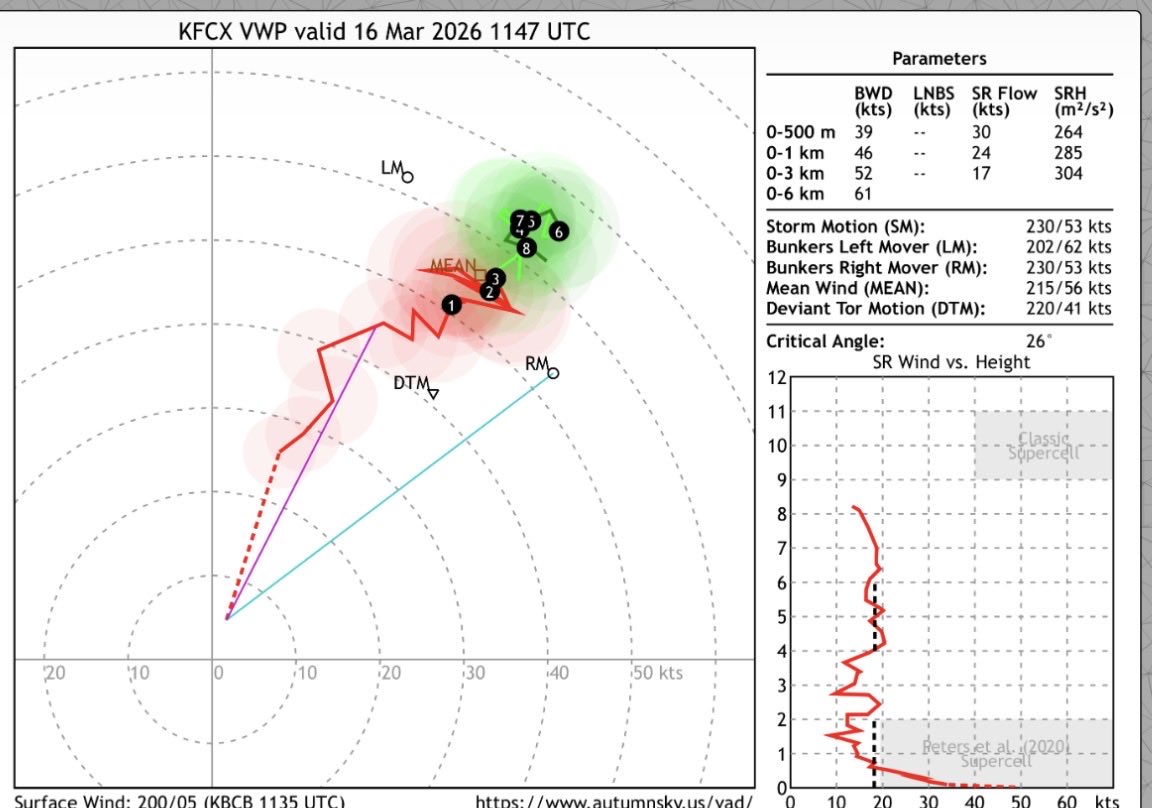
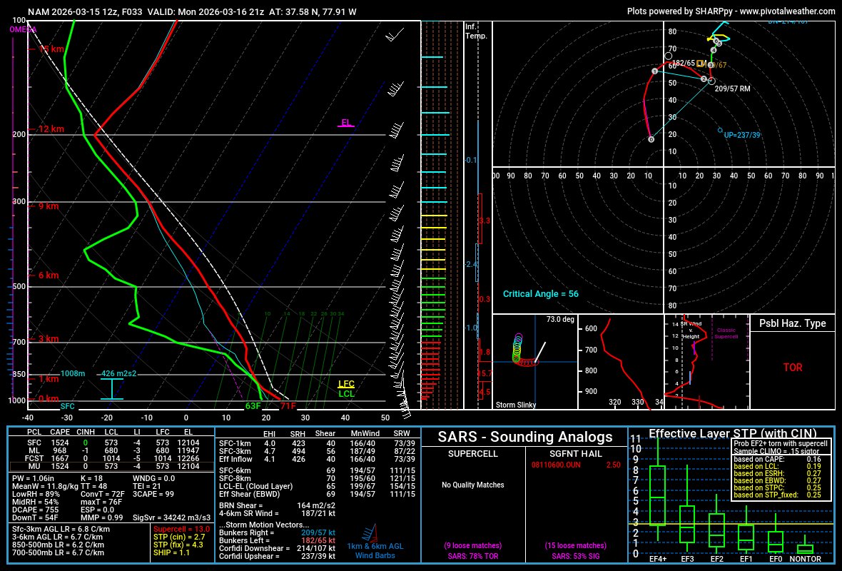
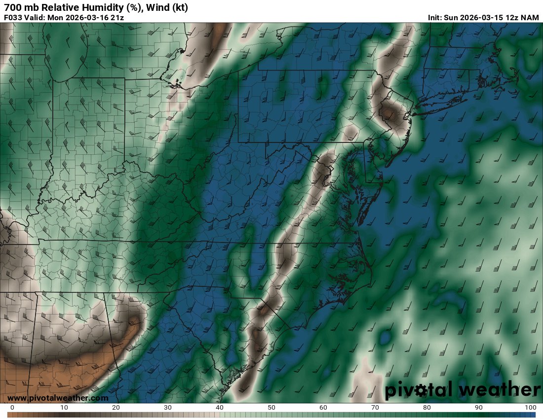
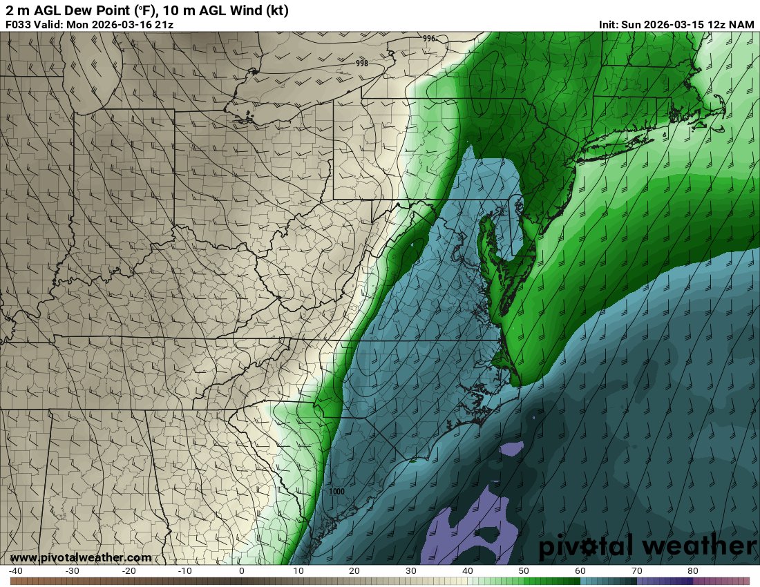
Trends have not been the Mid-Atlantic's friend. The prefrontal trough has trended slower. Besides the obvious implication of greater instability, the more worrying consequence is how the warm sector now aligns with an ejecting negatively tilted shortwave. (1/3) #vawx #ncwx
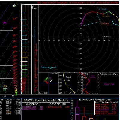
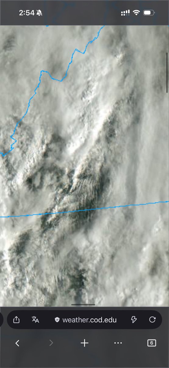
English
1
1
12
1.5K
Justin Buchinsky
Justin Buchinsky@JBuchinskyWX·
@SevereSoundings The kinematic environment along and ahead of that frontal passage is really quite something. The region is very fortunate the warm sector was worked over beforehand.
English
0
0
1
75
Justin Buchinsky retweetet
Andrew Shearer
Andrew Shearer@Drewshearer444·
The current evolution has considerably decreased tornado chances due to excessive convection. However, a robust wind threat remains very much on the table as a strong jet streak moves in, with a shallow convective line capable of significant damage winds occurring later today.
GIF
GIF
GIF
GIF
English
2
4
35
3.2K
Justin Buchinsky
Justin Buchinsky@JBuchinskyWX·
These thermodynamic profiles are not it if you’re looking for a significant severe weather event 😬 Also can see stable rolls cloud formations in Virginia. #vawx #ncwx
Justin Buchinsky tweet mediaJustin Buchinsky tweet mediaJustin Buchinsky tweet media
English
3
0
35
5.3K
Justin Buchinsky
Justin Buchinsky@JBuchinskyWX·
Immediately adjacent to the QLCS crossing the Appalachian Mountains surface winds are veered. This will limit tornado potential in the near term. Gusty winds and brief tornadoes remain possible due to the copious speed shear.
Justin Buchinsky tweet media
English
0
1
4
513
Justin Buchinsky
Justin Buchinsky@JBuchinskyWX·
First light shows filtered sunshine across the warm sector. This will allow for surface based inhibition to gradually erode from west to east. This degree of sunshine is honestly a little surprising given the amount of forcing and convection over the area. #vawx #ncwx
Justin Buchinsky tweet mediaJustin Buchinsky tweet media
English
1
2
37
4.4K
Brandon Payne 🥋
Brandon Payne 🥋@brandonwxOK·
Not too bad for my first South Carolina supercell #scwx
Brandon Payne 🥋 tweet media
English
5
6
138
8.7K
Justin Buchinsky
Justin Buchinsky@JBuchinskyWX·
@forecaster25 Remarkable surface winds are backing so hard with the parent low in Canada
English
1
0
11
2.3K
Peter Forister 🍁🍂🍁
Peter Forister 🍁🍂🍁@forecaster25·
A legit EML is showing up on the NAM now over a clean warm sector + a mesolow over Western VA. This is a higher-end scenario.
Peter Forister 🍁🍂🍁 tweet mediaPeter Forister 🍁🍂🍁 tweet mediaPeter Forister 🍁🍂🍁 tweet media
English
15
35
268
56.8K
Justin Buchinsky
Justin Buchinsky@JBuchinskyWX·
I can not recall ever seeing the Extreme Forecast Index show such, well, extreme, weather for such a widespread area! Record breaking #heatwave locked and loaded for next week.
Justin Buchinsky tweet media
English
0
5
29
2.2K
Justin Buchinsky
Justin Buchinsky@JBuchinskyWX·
@Brady_Wx Thank you for the response. I noticed the disparity in time steps but would have assumed that the high one hour probs would show a stronger reflection in the 12 hour forecast. Alas, I see they are different runs. Good luck with continued development.
English
0
0
0
43
Andrew Brady
Andrew Brady@Brady_Wx·
A couple of reasons: -The forecast in this screenshot is a 1hr timestep, not the entire 12hr period. -The forecast in this screenshot is from today, the last 12hr period forecast on the account was from Friday. Inside of 48 hours, the model updates every hour so we don’t do the 12hr chunk autoposts (currently)
English
1
0
1
87
Andrew Brady
Andrew Brady@Brady_Wx·
One of the greatest strengths of StormNet is the 2-min updates. It sees everything meteorologists are seeing in real-time, from fronts moving faster/slower or patterns on satellite. It is analyzing all of this data and making refinements to the forecast constantly.
StormNet@StormNetWx

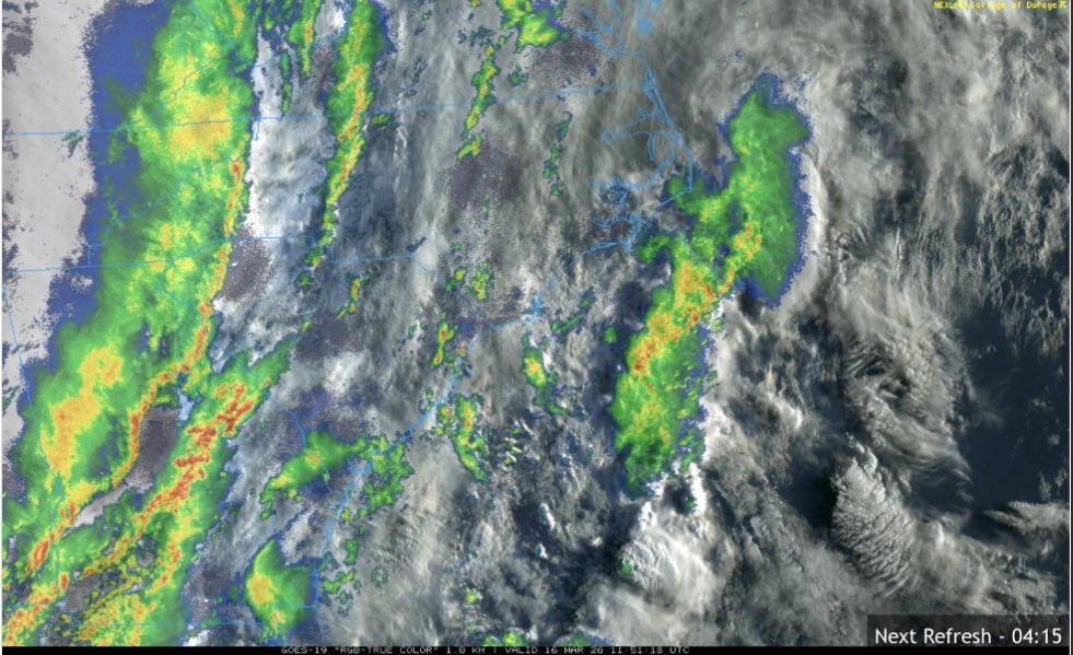
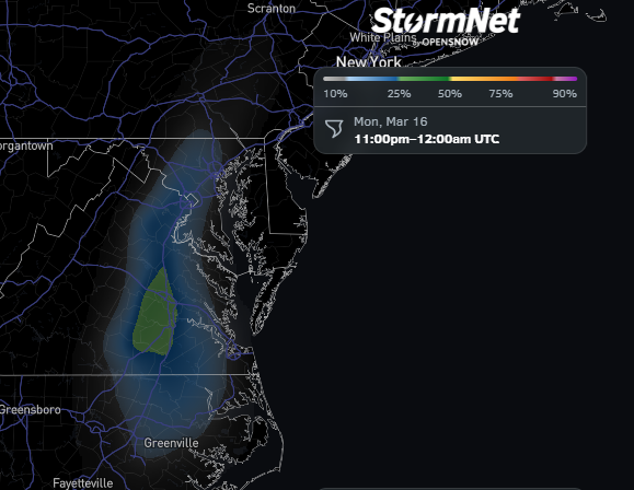
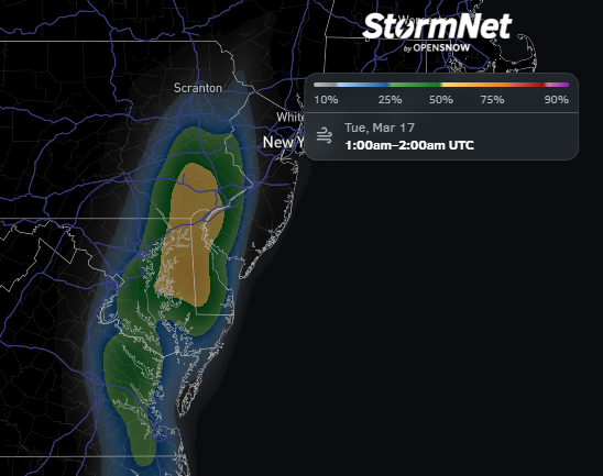
Severe storms and tornadoes are likely today and tomorrow across the eastern half of the country. Follow StormNet's tornado, wind, hail, and lightning forecasts through the event. The model runs every 2 minutes, always ingesting the latest atmospheric data available.

English
2
1
27
5.5K
Justin Buchinsky
Justin Buchinsky@JBuchinskyWX·
@weathermandave_ Also had the h word creep into my mind playing the same 500mb plot for myself this morning. Extremely impressive dynamics.
English
0
0
0
1.2K
Dave Downey⚡
Dave Downey⚡@weathermandave_·
This is just insane for the east coast/mid-atl. 50/50 high risk by 1630z tomorrow... Likely all depending on prevalence of AM junkvection
GIF
English
11
30
264
58.8K