NWS Pendleton

13.7K posts

NWS Pendleton banner
NWS Pendleton

NWS Pendleton

@NWSPendleton

Official Twitter account for the National Weather Service Pendleton. Details: https://t.co/LCpPXzpjtc

Pendleton Oregon Joined Haziran 2012
249 Following10.3K Followers
NWS Pendleton
NWS Pendleton@NWSPendleton·
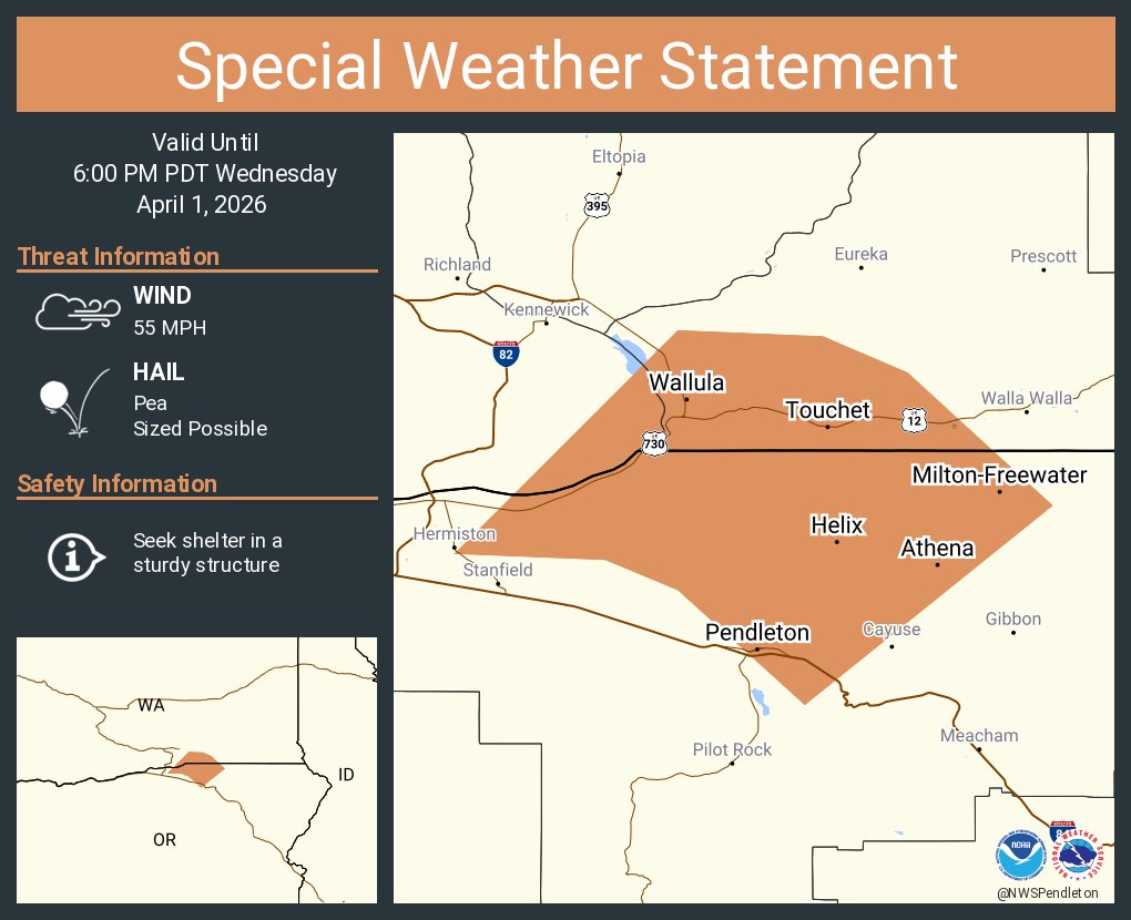
A special weather statement has been issued for Dayton WA, Waitsburg WA and Kahlotus WA until 7:15 PM PDT
NWS Pendleton tweet media
English
0
2
3
433
NWS Pendleton
NWS Pendleton@NWSPendleton·
A special weather statement has been issued for Walla Walla WA, College Place WA and Garrett WA until 6:30 PM PDT
NWS Pendleton tweet media
English
1
3
5
436
NWS Pendleton
NWS Pendleton@NWSPendleton·
A special weather statement has been issued for Pendleton OR, Milton-Freewater OR and Athena OR until 6:00 PM PDT
NWS Pendleton tweet media
English
0
1
4
303
NWS Pendleton
NWS Pendleton@NWSPendleton·
A special weather statement has been issued for Hermiston OR, Pendleton OR and Umatilla OR until 5:15 PM PDT
NWS Pendleton tweet media
English
0
2
3
397
NWS Pendleton
NWS Pendleton@NWSPendleton·
Widespread low probabilities of thunderstorms First thunderstorm potential of the season Will bring wetting rains and gusty outflow winds Highest probabilities are through the southeast and eastern portion of the region
NWS Pendleton tweet media
English
0
1
2
301
NWS Pendleton
NWS Pendleton@NWSPendleton·
Mountain snow will intensify Wednesday bringing heaviest snowfall rates overnight into Thursday morning. A Winter Storm Warning is in effect for the Eastern Slopes of the Oregon Cascades beginning late Tuesday Night. #WAWX #ORWX
NWS Pendleton tweet media
English
0
3
7
421
NWS Pendleton
NWS Pendleton@NWSPendleton·
Expect mountain snows to ramp up Tuesday Night for the Washington and Oregon Cascades, and the Northern Blue Mountains. Snow rates will become most intense Wednesday Night. #WAWX #ORWX
NWS Pendleton tweet media
English
0
5
10
1.4K
NWS Pendleton
NWS Pendleton@NWSPendleton·
Planning to head over the mountains midweek? We have high confidence (75%+) that mountain snow is returning, creating high potential for minor winter impacts April 1-2. If traveling, be sure to stay weather aware and get the latest by visiting WSDOT or TripCheck.
NWS Pendleton tweet mediaNWS Pendleton tweet media
English
0
2
4
442
NWS Pendleton
NWS Pendleton@NWSPendleton·
River levels are subsiding, but some areas of the Yakima and Naches Rivers are still in flood stage. #wawx
NWS Pendleton tweet mediaNWS Pendleton tweet mediaNWS Pendleton tweet mediaNWS Pendleton tweet media
English
0
3
3
461
NWS Pendleton
NWS Pendleton@NWSPendleton·
Minor river flooding is ongoing or forecast today through Monday for the Yakima and Naches rivers. #wawx
NWS Pendleton tweet media
English
0
3
3
324
NWS Pendleton
NWS Pendleton@NWSPendleton·
An upper level weather system moving across the region will continue to bring light to moderate snow across the northern Blues through this evening. Light snow will continue through tomorrow. #wawx #orwx
NWS Pendleton tweet media
English
0
2
4
539
NWS Pendleton
NWS Pendleton@NWSPendleton·
Snowmelt combined with recent runoff from heavy rain has resulted in increase flows along rivers, streams, and creeks stemming from the Northern Blue Mountains. River flooding is expected to continue through at least tomorrow morning. #wawx #orwx
NWS Pendleton tweet media
English
0
2
2
512
NWS Pendleton
NWS Pendleton@NWSPendleton·
A Winter Storm Warning remains in effect across the Upper Slopes of the Eastern Washington Cascades, bringing additional snow accumulations between 1 and 2 ft overnight and Friday. #wawx
NWS Pendleton tweet media
English
0
3
6
629
NWS Pendleton
NWS Pendleton@NWSPendleton·
A Winter Storm Warning remains in effect across the Upper Slopes of the Eastern Washington Cascades, bringing additional snow accumulations between 1 and 2 ft overnight and Friday. #wawx
NWS Pendleton tweet media
English
0
2
3
569
NWS Pendleton
NWS Pendleton@NWSPendleton·
A Winter Storm Warning remains in effect across the Upper Slopes of the Eastern Washington Cascades, bringing additional snow accumulations between 1 and 2 ft overnight. #wawx
NWS Pendleton tweet media
English
0
2
1
582
NWS Pendleton
NWS Pendleton@NWSPendleton·
A cold front passage Wednesday night will tap into strong low level jet winds, producing breezy to windy conditions across portions of the Lower Columbia Basin, Blue Mountain foothills, and adjacent areas. #orwx #wawx
NWS Pendleton tweet media
English
0
4
8
690
NWS Pendleton
NWS Pendleton@NWSPendleton·
Heavy snow is in the forecast for the Cascade passes Wednesday night through Thursday. Strong winds and low visibility could make driving conditions difficult. Please check the forecast (weather.gov) & pass conditions (wsdot.com/passes) before departing. #wawx
NWS Pendleton tweet media
English
0
1
6
505
NWS Pendleton
NWS Pendleton@NWSPendleton·
Gusty winds up to 60 mph are expected for Wednesday evening through Thursday morning, which could affect drivers on major interstates and routes. Please check the forecast (weather.gov) & pass conditions (wsdot.com/passes) before departing. #wawx
NWS Pendleton tweet media
English
0
2
3
516
NWS Pendleton
NWS Pendleton@NWSPendleton·
A winter weather system moving through the area today and tomorrow will bring moderate snow accumulations to portions of the Oregon Cascade east slopes and the Northern Blue Mountains in Washington. #wawx #orwx
NWS Pendleton tweet media
English
1
2
5
1.3K