alluringstorms 🇨🇦

117.3K posts

alluringstorms 🇨🇦 banner
alluringstorms 🇨🇦

alluringstorms 🇨🇦

@alluringstorms

Hi, I'm Paxton!! I'm a storm photographer in Ontario!🌪 Count: 3 (and 4 spouts) Links: https://t.co/tDuWuM2AJL

Hamilton, ON / Caledon, ON Se unió Eylül 2020
2.3K Siguiendo3.2K Seguidores
Tweet fijado
alluringstorms 🇨🇦
alluringstorms 🇨🇦@alluringstorms·
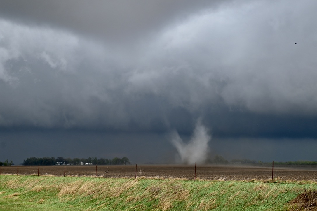
Just realized I haven't posted my other decent shot of the Bergen, AB EF2 Tornado from July 7th, 2022! This was after it came out from inside those rain curtains of the first photo I had posted. Personally, it's my favourite shot of that day! 😳 #StormHour #ABwx #ThePhotoHour
alluringstorms 🇨🇦 tweet media
English
19
22
202
0
alluringstorms 🇨🇦 retuiteado
Instant Weather Ontario ❄️
#ONStorm #ONwx Looks like the heat forgot its passport… while much of the United States is currently dealing with record-breaking temperatures for this time of year, there is still no sign of that kind of warmth across Southern Ontario. But you do not have to go very far to find it. Parts of Ohio and Pennsylvania are currently seeing temperatures climb to around 30°C, which is pretty wild for late March! That is roughly 10 to 15°C above average for this time of year. Looking farther ahead, there are some signs that we could get a shot of warmer air toward the end of the month or into early April. That is still a long way out though, so we will have to wait and see how that trend holds. For now, Ontario’s second winter is still very much in full effect… - Brennen
Instant Weather Ontario ❄️ tweet media
English
25
23
211
24.7K
alluringstorms 🇨🇦 retuiteado
MyRadar Weather
MyRadar Weather@MyRadarWX·
Vortex breakdown is a dramatic thing to see unfold within tornadoes. It results in a sudden loosening and widening of the visible condensation funnel, as well as a momentary expansion and brief weakening of the winds. It occurs when there's a slowdown in upward motion inside the tube-like funnel. That quickly "jams" the spiral motion into the funnel, causing the tightly-wound column of spin to bulge outwards and expand, slowing the winds via the conservation of angular momentum. In some instances, this can cause a full breakdown of the funnel. @MatthewCappucci captured this photo of a tornado undergoing vortex breakdown AND developing a secondary suction vortex simultaneously on April 26, 2024 near Dwight, Nebraska.
MyRadar Weather tweet media
English
0
7
62
5.6K
alluringstorms 🇨🇦 retuiteado
Sam Brandt
Sam Brandt@sambrandt99·
Huge, but likely non-rotating wall cloud on this thing
Sam Brandt tweet mediaSam Brandt tweet media
English
0
3
48
2.5K
alluringstorms 🇨🇦 retuiteado
Peter Corman
Peter Corman@PeterC428·
BEAUTIFUL supercell with a wall cloud approaching the State College Airport! #pawx
Peter Corman tweet media
English
1
16
127
4.5K
alluringstorms 🇨🇦 retuiteado
Kathleen
Kathleen@tmszhjh88·
It's too stable.
English
43
4.9K
47.4K
1M
alluringstorms 🇨🇦 retuiteado
I'm From Cleveland
I'm From Cleveland@ImFromCle·
This might be one of the wildest weather splits we’ll see all year. At the same time parts of Ohio climb into the 70s and even mid-80s, Cleveland will still be sitting in the upper 30s due to cold air blowing in off Lake Erie. That sharp contrast is coming from a cold front combined with wind off the lake, creating a narrow band of much colder air across Northeast Ohio while the rest of the state warms up. Same state. Completely different day.
I'm From Cleveland tweet media
English
59
197
1.7K
184.8K
alluringstorms 🇨🇦 retuiteado
Zoë Paramour
Zoë Paramour@ZoeParamour·
Any expert gardeners who can help me identify what I’ve grown here? Is it invasive?
Zoë Paramour tweet media
English
498
577
8.4K
73.4K
alluringstorms 🇨🇦 retuiteado
Sam Brandt
Sam Brandt@sambrandt99·
@CameronJNixon High-based supercell with a rain/hail shaft partially obscuring the ridge line that is passing over with farmland in the foreground
Sam Brandt tweet media
English
2
2
15
818
alluringstorms 🇨🇦 retuiteado
Sam Brandt
Sam Brandt@sambrandt99·
You can see the depression of surface RH (proxy for LCL height) downwind of the Allegheny front on the HREF
Sam Brandt tweet media
English
0
1
3
496
alluringstorms 🇨🇦 retuiteado
Sam Brandt
Sam Brandt@sambrandt99·
Composite sounding from all the HREF members for tomorrow across central PA along with some thoughts.
Sam Brandt tweet media
English
5
8
52
3.3K
alluringstorms 🇨🇦 retuiteado
World Climate Service
World Climate Service@WorldClimateSvc·
Daily Niño3.4 SST anomaly: 0.00 The transition is under way. However, the relative index (rNiño3.4) still has some distance to go before reaching neutral.
World Climate Service tweet mediaWorld Climate Service tweet media
English
5
15
64
3.1K
alluringstorms 🇨🇦 retuiteado
Peter Corman
Peter Corman@PeterC428·
Oh okay
Peter Corman tweet media
English
3
3
71
46.7K
alluringstorms 🇨🇦 retuiteado
Star
Star@StarInBoxWx·
Today is a prime example of UH≠tornadoes. Very well-mixed low-levels will create high-based storms, and while a few storms may exhibit robust mesocyclones, they will struggle to reach toward the surface, favoring more large hail than tornadoes.
Star tweet mediaStar tweet mediaStar tweet media
English
0
9
98
7K
alluringstorms 🇨🇦 retuiteado
Nadocast
Nadocast@nadocast·
12Z Day Tornado Forecast (New New 2022 Models)
Nadocast tweet media
English
2
9
55
9.5K
alluringstorms 🇨🇦 retuiteado
Tyler Sebree ⚡️
Tyler Sebree ⚡️@TylerSebreezy·
The latest update from @NWSSPC regarding today's severe risk in Ohio keeps things at a level 2-of-5 slight risk for most locations. Large hail and damaging winds are the primary concerns. A tornado cannot be ruled out if convection remains surface based. #OHwx
Tyler Sebree ⚡️ tweet mediaTyler Sebree ⚡️ tweet mediaTyler Sebree ⚡️ tweet mediaTyler Sebree ⚡️ tweet media
English
3
7
24
2.5K