Sabitlenmiş Tweet
Matthew Cappucci
76.2K posts

Matthew Cappucci
@MatthewCappucci
Atmospheric scientist, storm chaser, adventurer, teacher, author. Senior meteorologist at @MyRadarWX. Usually found frolicking in giant hail. Harvard/MIT 🌪

Washington, DC Katılım Haziran 2014
411 Takip Edilen126.6K Takipçiler
Matthew Cappucci retweetledi

NEW: A HIGH risk of flash flooding and excessive rainfall has been drawn through Wednesday morning, July 15! This includes the Highway 90 corridor in the Rio Grande Valley near/west of San Antonio, including in Hondo, Del Rio, Bracketville and surrounding areas.
High risks are only drawn 4 percent of the time, but account for 80 percent of all flood-related financial losses and 36 percent of fatalities!

English
Matthew Cappucci retweetledi

Through THURSDAY, July 16, we'll have some serious flood concerns in Texas Hill Country. The greatest risk is from Del Rio and the Permian Basin through the Edwards Plateau and Balcones Escarpment, but all the way to Houston could see some flooding.
The risk area includes Sheffield, Rocksprings, Junction, Del Rio, Uvalde, San Antonio, Kerrville and Fredericksburg.
Remember how flooding works in Hill Country – all the water is funneled into only a few river valleys, leading to more focused impacts that can, at times, be extremely serious.
Hunt, Texas is in the risk area again. That's home to Camp Mystic, where 25 girls and two campers died in floodwaters a year ago this month. The camp has since filed for chapter 11 bankruptcy, which may temporarily pause ongoing lawsuits.
This is a VERY different setup BUT illustrates the dangers of heavy rain in hilly terrain.
Moisture is pooling along a stalled frontal boundary. Every column of atmosphere is holding ~2.2 or 2.3 inches of moisture. Storms are squeezing that moisture out of the air like they're wringing out a sponge. BUT that moisture is being constantly replenished by moist southerly flow out of the Gulf.
That means some double-digit totals of 10-15 inches are likely, including along parts of the Interstate 10 and Highway 90 corridors.
We'll also have "efficient" precipitation. Ordinarily, dry air erodes a percentage of raindrops as they fall down; perhaps 10, 20 or 30 percent of a raindrop evaporates between the time it falls from the cloud and when it hits the ground. That usually means a bit less water reaching the ground.
But because the atmosphere is saturated at basically all levels within the clouds, there’s no dry air to eat away at raindrops. Instead, the whole glob of water will fall. That “efficient” rainfall leads to higher rainfall rates. A few downpours could drop 2 to 3 inches in a single hour.

English
Matthew Cappucci retweetledi

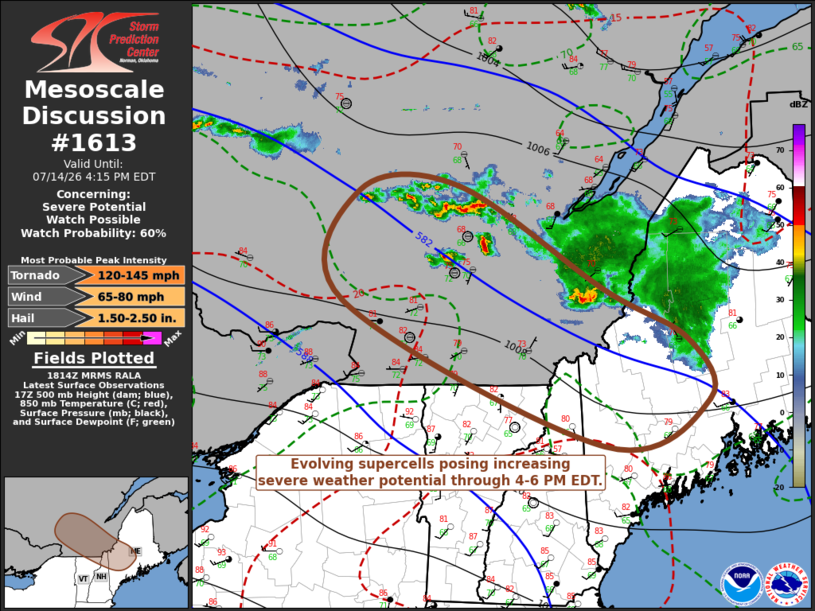
TODAY, July 14 is a legitimate supercell/severe weather day across parts of northern New England and southern Quebec.
Several rotating supercells capable of a couple tornadoes, large hail (up to pool ball size) and destructive gusts are possible.
Storms may eventually congeal into one or more squall lines with sporadic destructive gusts of 70+ mph.
In Canada Montreal, Quebec City, Sherbrooke, Saint-Georges and folks along the St. Lawrence River are most at risk of scattered afternoon supercells.
In the U.S., we're really watching western Maine, especially Rumford, Skowhegan, Jackman, Greenville, Ranglev... then northern New Hampshire, especially Berlin, Conway, Littleton, Colebrook, Gorham... and then northern Vermont, especially Burlington, Barre, Saint Johnsbury, Lyndon, Newport, etc.
Please – have a way to be notified of warnings. Be prepared to seek shelter if a warning is issued.

English

Y’all will never guess who scored 80% off chartering a big sailboat on the Mediterranean in exchange for doing a presentation about meteors. 😀
Landon Moeller@landon_wx
The Perseid meteor shower peaks in one month (early morning Aug 13)! This time, without a disruptful moon!
English

@Bopegfs @MikeTFox5 I like that the calendar only has six days per week. 🤣
English

@MatthewCappucci Matt I want to see this scale on an AI generated weather image please! 🙏
English

Some folks pushing back against Spann — I actually agree that this is most likely scud (clearly rotating scud, but scud).
Very low swirl ratio. Cloud is obviously inhaling air from below, but minimal spin, and not really a single, cohesive vortex. [1/2]
James Spann@spann
Today’s creepy scud special… northern Madison County late this morning. Video from Bob Carter.

English

@MaxVelocityWX @CheeseCurdCat Call it Min Velocity 🤣
English

@MatthewCappucci @CheeseCurdCat I’ll make an account for my pickle
English

hi everyone, i’m the real star of the max velocity household. my hobbies include sleeping, causing problems, and attacking pickles. my cat dad is @MaxVelocityWX or something. follow me for important updates. 🐾🥒

English

Brb launching a full-fledged investigation to uncover Reilly's middle name
Reilly Dibble@Simcoe12_Wx
BANGGGGGGGGG
English