
Dr. Ashay Sahasrabuddhe (PhD) がリツイート

Let me explain what just happened today because it deserves so much recognition.
GalaxEye is a Bengaluru startup founded in 2021 by IIT Madras engineers. Today they launched Mission Drishti on a SpaceX Falcon 9. It is India's largest privately built satellite at 190 kg. And it carries a technology that no commercial satellite has ever carried before.
Normal satellites take photos of the Earth using optical cameras. Like your phone camera, but from 500 km up. The problem is obvious. Clouds. Night. Fog. Smoke. If any of these are in the way, the photo is useless. India has monsoon cover for 4 months a year. That is 4 months where optical satellites are partially or fully blind over large parts of the country.
The alternative is SAR. Synthetic Aperture Radar. Instead of taking photos with light, it sends radar waves down and reads what bounces back. Radar goes through clouds, through darkness, through smoke. A SAR satellite can image a flooded village at 2 AM during a cyclone when no optical satellite can see anything.
The problem with SAR is that the images look nothing like photos. They look like grainy black-and-white radar maps. A military analyst or a trained geospatial engineer can read them. A farmer, a disaster response team, or a city planner cannot.
Until today, if you wanted both optical and SAR data for the same location, you needed two different satellites, passing over at different times, at different angles. Then someone had to manually align and fuse the two datasets. Expensive, slow, and the data never perfectly matched because the satellites saw the same spot minutes or hours apart.
GalaxEye put both sensors on one satellite. Optical and SAR, fused into what they call OptoSAR. Three times more information than a single sensor. Processed onboard by an NVIDIA AI chip at 1.8 metre resolution.
Now in practice, during the next cyclone hitting Odisha, one satellite pass gives you a clear image of which villages are flooded, which roads are cut, and which buildings are standing. Day or night. Cloud or clear. In near real-time.
For defence, it means you can monitor a border area 24/7 regardless of weather. For agriculture, it means tracking crop health across an entire monsoon season without a single cloud gap. For infrastructure, it means monitoring construction progress on highways and bridges without waiting for a clear day.
GalaxEye tested their SAR tech on ISRO's POEM orbital platform. The satellite was tested at ISRO facilities. IN-SPACe provided regulatory clearance. NSIL, ISRO's commercial arm, will distribute the imagery globally. And it launched on SpaceX because ISRO's PSLV doesn't have the right orbit slot for this mission.
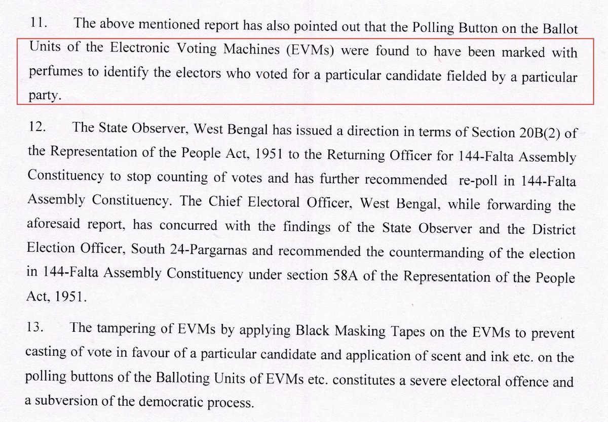
Yes, four IIT Madras graduates built a world-first satellite in 4 years in Bengaluru.
Take a bow!
Tejasvi Surya@Tejasvi_Surya
A Bengaluru startup just did something no one in the world has ever done, put a satellite in orbit that sees through clouds, through the night, with optical sensor and SAR fused into one. Many many congratulations to the @Galaxeye team on the launch of Mission Drishti! This is exactly why PM Sri @narendramodi opened up the space sector, so young Indians could build an audacious future for the nation.
English