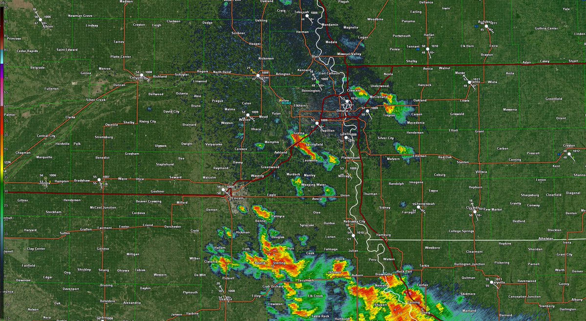
5:23 PM Radar Update
Take it slow on the evening commute as thunderstorms travel through the Omaha metro. Heavy rainfall may bring brief, intense drops in visibility along with small hail.
18z OAX sounding shows significant capping as well as increasing instability. Lapse rates are already pretty high. Considerable dry air with Td spread of 29°. DCAPE over 1300 J/kg may support a damaging wind threat, while the increasing lapse rates and MLCAPE may support an isolated large to very large hail threat with any storm that can develop. Right now, best odds of convective development still looks to be in extreme far eastern NE (including Omaha), going into western IA. There does remain a chance for storms to develop near Mills, Fremont, Page and Montgomery counties, as painted by the 00z/12z NAM3km, but predictability of that occurring is lower than the chances of storms developing in far eastern NE/western IA.
Once again, any storm that can develop and intensify will have the capability of producing large to very large hail (max size: 2") and wind gusts near 65mph, however predictability of where storms may develop remains low. Best timing for these storm chances: after 4pm.
#newx#iawx#wxtwitter#severe#weather
WINTER STORM TO IMPACT ALL OF EASTERN NE/WESTERN IA... WIND GUSTS AS HIGH AS 70MPH WILL CREATE WHITEOUT CONDITIONS THIS WEEKEND... WEATHER FCST DISCUSSION:
As a trough emerges from Wyoming/Colorado, a strong low pressure system will develop with it. The position of the low pressure system will likely be a critical piece into determining where the greatest snowfall amounts and associated high wind gusts will be. As of now, the wind gusts are expected to be widespread, regardless of the sfc low location. The snow amounts will vary based on location. For example, the GEFS has the sfc low over north-central NE at 06z Sunday, while the EPS AIFS has the sfc low over central KS at 06z Sunday.
Looking at ensemble models at this point, snowfall amounts do not look to be overly high, with a mean average of 1-3" across northeastern NE, lower amounts farther south and west. The GEFS is an outlier among the 5 ensemble models, showing up to 3" of snow for the Omaha metro area. The NBM shows up to 1-2" of snow for the Omaha metro area, higher in northeast NE where the NBM is showing 2-4".
Personally, I don't think the snowfall amounts will be a significant issue. The wind gusts associated with the snowfall will be the main issue. Wind gusts as high as 70mph are likely across all of eastern, northeastern, southeastern and western IA. This will create periods of whiteout conditions with blizzard conditions possible. Travel is strongly discouraged between late Saturday night through the majority of Sunday and possibly even early morning hours Monday.
Please consider delaying travel if you need to drive during that time frame. This will likely be an impactful event with widespread power outages likely. If you must travel, pack an emergency kit with you.
#newx#iawx#wxtwitter#winter#weather
10:12pm Radar Update:
Showers and thunderstorms continue to develop across southeastern and far eastern NE, and continue to move northeast. The strongest storms will be capable of producing 1" hail and/or 60mph wind gusts. I will be able to provide updates until 1-2am.
#newx#iawx#wxtwitter
Will be posting a LOT of severe weather updates starting tomorrow and Friday. Friday looks to be a lot more impactful, with tornadoes possible. Stay tuned.
#newx#iawx#wxtwitter
@GodlyNations warped sense of self esteem, zero self awareness, hatred for anyone that’s not white & blonde, zero self respect, husbands 30 years older and a huge lack of empathy & compassion
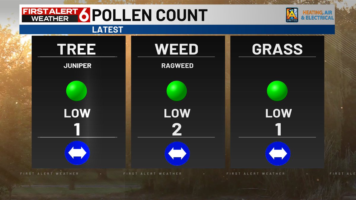
Pollen count all on the low side per the latest reading this morning. This will be the last count of the 2025 season per the Douglas County Health Dept.
NWS is hiring! Are you interested in working for an agency that uses science and technology to protect lives and property? Additional mission-critical positions just posted on USAJobs.gov, including Meteorologist (1340) openings. Many are great opportunities for first-time hires. More coming soon!
After media reports & experts warned for months that drastic & sudden cuts at the Nat Weather Service by Trump could impair their forecasting ability & endanger lives during the storm season, TX officials blame an inaccurate forecast by NWS for the deadly results of the flood.