20"+ OF RAIN is likely over the next 48 hours near San Antonio, Texas...
A rare "high" risk of excessive rainfall is in place just outside of San Antonio, where an abundance of moisture is set to dump a catastrophic amount of rainfall over the next few days. This is a very concerning situation.
**HIGH RISK OF EXCESSIVE RAINFALL** in Texas today, where catastrophic flooding is becoming increasingly likely for Uvalde, Del Rio, and San Antonio!
Localized 12-24" of rain could fall today and tomorrow. If you live in a low-lying area, you need to plan on getting to higher ground. Turn around, don't drown!
TORNADO RISK UPGRADE in Maine and New Hampshire today, where a few EF-2+ tornadoes are possible this afternoon...
This setup is RARE. This is the first time we've ever had an enhanced risk of severe weather for these areas, in addition to an EF-2+ tornado threat outlined by the SPC. Live stream is possible!
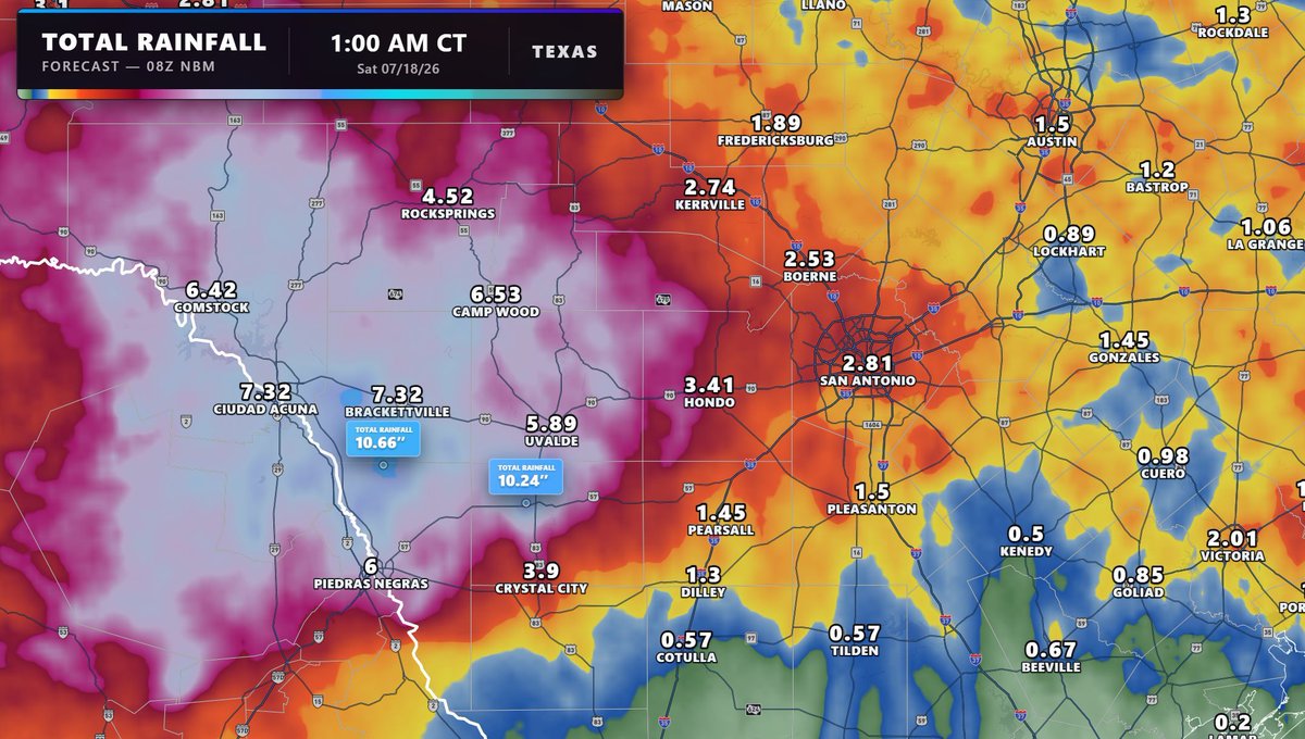
A wide swath of 6-10" rainfall amounts continues to be forecast the next several days west of where I-10 and I-35 meet, with the potential some areas locally could see more. This will only compound the impacts caused by the amount of rainfall that has fallen, with over 8" of rain having already fallen in multiple spots outside the western suburbs of San Antonio.
A prolonged, life-threatening heavy rain event continues to unfold, where a moderate risk of excessive rainfall continues the next 3 day for portions of central Texas, from San Antonio westwards. Climatologically, precipitable water in this region is in the 95-99th percentile, and given slow moving storms, dangerous flash flooding will be easy to come by especially given rainfall that has already occurred.
Hourly rainfall rates in the heaviest of storms will exceed 2", with widespread totals of 5-10" forecast by the end of this week with some areas having the potential to exceed that. Soil moistures are becoming increasingly compromised, and with recent uptrends in models, a high risk may be necessary in future outlooks.
Before we even get to the severe weather later today, thanks to current wildfires in Quebec, smoke will continue to be pushed into much of the Northeast and into the Mid-Atlantic throughout the remainder of the day, leading to prolonged hazy conditions.
This could ironically be something to monitor as we head into the remainder of the day, as haze can block some of the radiation from the sun, potentially leading to forecasted temperatures today underperforming, leading to less instability in the atmosphere. Whether this will have an impact on storms firing later today or not remains to be seen.
Smoke scatters shorter wavelengths of light (blue/violet) while amplifying reds and oranges, which means this could make for a very vibrant sunset tonight, especially across coastal Massachusetts and southern New Jersey.
The best chance of tornadoes today will be across northern New England, where mixed modes of convection will favor some discrete supercells. A strong (EF-2+) tornado or two is possible if supercells can remain surface-based without growing upscale.
This is the first time a hatched tornado risk has occurred for tornadoes in much of this region. The 2nd image in this post shows the last issuances from the old system which was used from 2002 until March 2026, when the current system was introduced.
For the first time in history, a level 3 risk is in place across much of northern and western Maine, with this categorical risk also present across the northern portions of New Hampshire, Vermont, and New York. A fast moving Canadian shortwave trough and its associated jet streak are digging southeastwards, perfectly timed to intercept a very moist boundary layer. Strong daytime heating will allow for more than sufficient instability, with thunderstorms expected to develop sometime in the mid-to-late afternoon hours. Storms should initiate in Canada closer to Montreal and Quebec, with subsequent clusters tracking rapidly southeastwards into the evening.
The arrival of a mid-level jet will maximize large-scale ascent while ramping up deep-layer shear to be anomalously high for this region. This overlap will support a dangerous mixed convective mode consisting of discrete supercells and growing linear segments. Bowing lines will pose a significant wind threat, with wind gusts potentially greater than 70mph possible. Additionally, with all the shear, intense, rotating updrafts are favored presenting a risk for large hail (which could be >2" diameter locally) along with tornadoes. A strong tornado or two could exist with any supercells that can sustain and remain surface-based.
This is an incredibly rare event in an area that does not see severe weather often, especially of this magnitude. Maine only averages 2 tornadoes in a year, and the last confirmed tornado in northern Maine specifically was in June 2010, when an EF-1 touched down in Penobscot County. It will be critical to have a way to receive warnings throughout this afternoon into the early overnight hours if you are in today's risk.
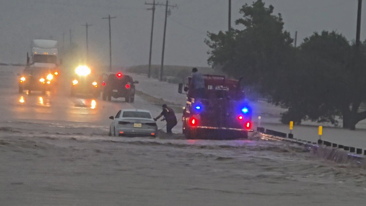
A state of emergency has been declared in Texas, as a multi-day threat of life-threatening flash flooding continues. High precipitable water rates combined with storm motions being very slow will continue through the next several days, keeping round after round of storms moving through, each posing the threat for significant flooding.
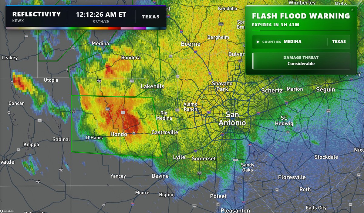
Flash flood warnings are already going into effect west of San Antonio, and models have continued to significantly uptrend on the rainfall totals expected by this weekend...
Tomorrow, SpaceX launches Starlink Group 10-45 at 5:10am EDT. While cloud cover could present challenges in the Southeast, a break in the clouds could allow you to see a rare phenomenon called "space jellyfish" to occur! This is only possible close to sunrise, with sunlight illuminating the expanding exhaust plume high in the atmosphere while the ground remains in darkness.
WILDFIRE OUTBREAK happening right now in Ontario!
Several fires have erupted over the past few hours, as very windy and dry conditions settle in, along with brutal heat!
@WxFront
hi everyone, i’m the real star of the max velocity household. my hobbies include sleeping, causing problems, and attacking pickles. my cat dad is @MaxVelocityWX or something. follow me for important updates. 🐾🥒
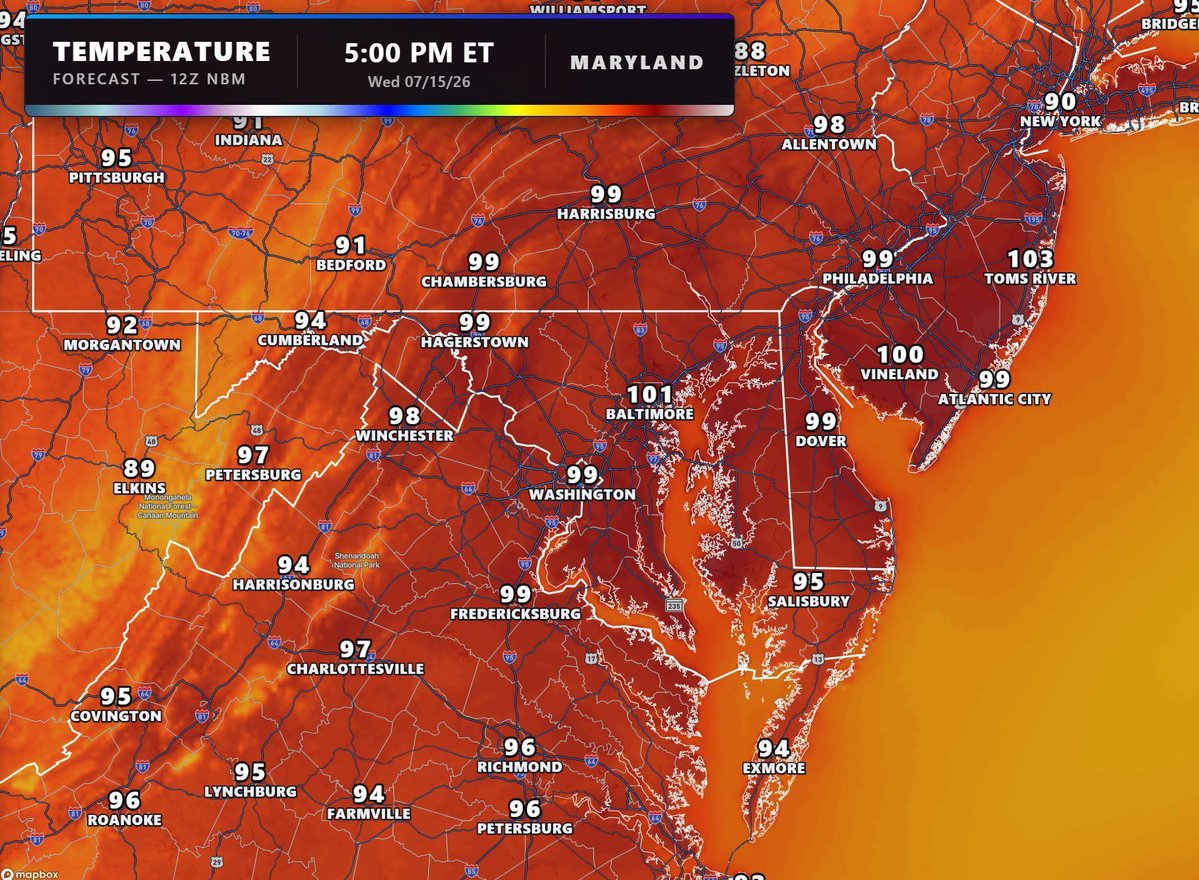
Dangerous heat returns to the Mid-Atlantic in time for Wednesday and Thursday, where highs will be in the upper 90s to low 100s. Unlike the heat wave we had for the 4th of July weekend, dew points will be lower leading to less humidity in comparison, but heat indices could still reach 105-110 across a wide swath of the region.
Excessive Heat Watches associated with this have already been posted for the Philly/Trenton area, with Heat Advisories expected to be issued as we get closer to Wednesday.
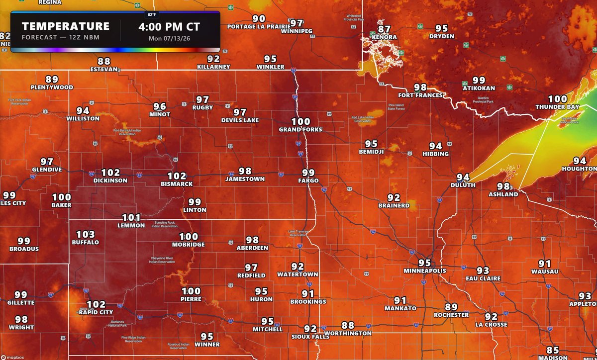
Temperatures continue to climb across the Dakotas and Minnesota, where temperatures could once again top 100 in spots later this afternoon. Temperatures across the Dakotas and Minnesota especially will continue to remain 15-25 degrees above normal for much of this week.