

Jonathan Pommier
236 posts
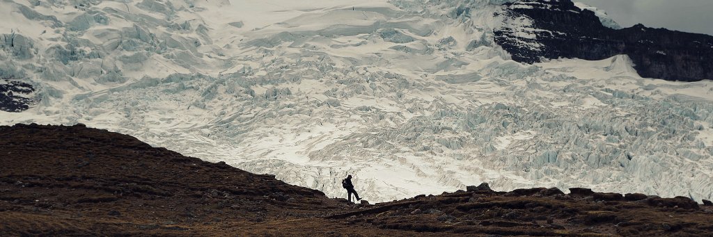

Le record actuel du Royaume-Uni pour le mois de juin s'élève à : 35,6 °C
à Camden Square à Londres en.....1957
à Southampton en ......1976
Les vagues de chaleur les plus mortelles en Europe sont presque toujours causées par des « blocs Oméga », un schéma atmosphérique nommé d'après la lettre grecque Ω.
Une crête de haute pression s'installe sur une région, flanquée de deux systèmes de basse pression, créant une sinuosité en forme de fer à cheval dans le jet stream. Le résultat est un dôme de chaleur : un « couvercle » de haute pression emprisonnant l'air chaud près de la surface.
L'été 2003, l'été européen le plus chaud depuis au moins 1540, a été entraîné par l'un d'eux.
Un air plus propre a réduit l'effet de refroidissement autrefois fourni par certaines formes de pollution.
Liz Kershaw@LizKershawDJ
Hot Hot Hot? Facts from @Telegraph The current UK record for the month of June stands at: 35.6C in Camden Square London in.....1957 in Southampton in ......1976 Europe’s deadliest heatwaves are almost always caused by "Omega Blocks" an atmospheric pattern named after the Greek letter Ω. A ridge of high pressure sits over one region, flanked by two low-pressure systems, creating a horseshoe-shaped kink in the jet stream. The result is a heat dome: a “lid” of high pressure trapping hot air near the surface. The summer of 2003, the hottest European summer since at least 1540, was driven by one. Cleaner air has reduced the cooling effect once provided by some forms of pollution.
Français


@AnntoineB @silvano_trotta @AFP Je n'ai jamais dit que nous n'étions pas assez débiles pour le faire champion.
Français

@AthendJon @silvano_trotta @AFP Mais oui Jonathan l’effet de serre 😂😂
C’est donc pour ça qu’on a fait la coupe du monde dans 3 pays différents à 4.000km d’intervalle pour éviter les déplacements et sauver la planète 🙃🙃🤡🤡
Français

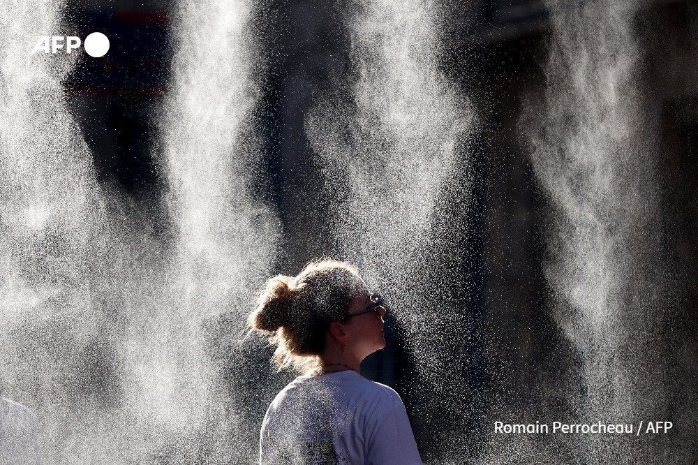
Scientists have shown that recurring heatwaves are a clear marker of global warming, and warn they are set to become more frequent, longer and more intense. Here are the latest developments in Europe's heatwave 🥵 u.afp.com/SzLW
English
@silvano_trotta Il racle, il racle, il racle.
Inférieur de 20°C, par rapport à ?
Soyez sérieux, apportez des informations qui le sont.
Français
Depuis plusieurs semaines déjà, une masse d’air nettement plus froide que la moyenne est présente au-dessus de l’Antarctique. Dans les jours à venir, les températures devraient y rester inférieures de plus de 20 °C (!!!!) à la moyenne à long terme (voir la vidéo). Cette masse d’air antarctique se concentre principalement au-dessus du continent, où elle persiste depuis un certain temps. Ces derniers jours, une partie de cet air froid s'est également étendue jusqu'en Amérique du Sud, entraînant là-bas aussi des températures hivernales inférieures à la moyenne.
Pendant que nos escrocs du climat qui empochent 1900 milliards de dollars par an sur le dos du petit C02 qui ne compose que 0,04% de l'atmosphère terrestre, et dont l'homme n'est responsable que de 3% des émissions, ne se dirigerait-on pas vers un nouvel petit âge glaciaire catastrophique pour l'humanité.
Rappel : pendant que les escrocs du climat, les médias, nos politiques HURLENT à la canicule, je rappelle que le Froid tue 10 fois plus de personnes dans le monde et sur chaque continent que la chaleur. Mais on ne les entend hurler que quand il fait chaud... Pourquoi ???
Ventusky@Ventuskycom
For several weeks now, a significantly colder-than-average air mass has been present over Antarctica. 🧐🥶 In the coming days, temperatures there are expected to remain more than 20 °C / 40 °F below the long-term average (see the video). This mass of Antarctic air is concentrated mainly over the continent, where it has persisted for an extended period. In recent days, some of this cold air has also spread into South America, bringing below-average winter temperatures there as well: #p=-29.1;-55.3;4" target="_blank" rel="nofollow noopener">ventusky.com/temperature-ma…
Français
@silvano_trotta @AFP Et quel rôle joue-t-il dans l'effet de serre ?
Français
@AFP Le froid tue 10 fois plus de personnes que la chaleur sur chaque continent ! Mais le froid ne permet pas d'empocher 1900 milliards de dollars par an de taxes et malus sur le petit CO2 qui représente 0,04% de l'atmosphère et dont l'humain est responsable à 3% .
Français
Un dôme de chaleur est coincé sur une partie de l'Europe. Cela arrive, c'est déjà arrivé, cela arrivera encore.
Kutay Mıhlıardıç@KutayMihliardic
🌍🌡️ The 2nd wave of the Heat Dome scorching Europe is coming! This Saturday, Hannover (Germany) will be roasting at 40°C (feels like 44°C!), while you could be throwing snowballs in the highlands of the Black Sea region in Türkiye. The climate has officially lost its mind.❄️
Français

J'avais fait un peu de météorologie à la fac. À l'époque, on parlait de "nuits tropicales" lorsque la température minimale restait au-dessus de 20°C, et de nuits exceptionnellement chaudes lorsque l'on dépassait 25°C. Dans le langage courant, une canicule évoquait souvent des journées >35°C accompagnées de nuits >20-25°C. Mais il n'existait pas de système de seuils départementaux standardisés.
Après la vague de chaleur de 2003, la définition opérationnelle a été entièrement restructurée autour d'un objectif sanitaire.
Aujourd'hui, en France une canicule est définie par des seuils de jour ET de nuit.
Ces seuils varient selon le département et Ils doivent être dépassés pendant au moins 3 jours et 3 nuits consécutifs.
Par exemple :
Paris : 31°C le jour et 21°C la nuit
Toulouse : 36°C le jour et 21°C la nuit.
Nice : 31°C le jour et 24°C la nuit.
Vous saisissez l'arnaque? 3 nuits à 21 degrés et hop!😂😂😂
Français
@Jojo_le_poisson @Stephane_Poli @meteofrance @lachainemeteo Ce n'est pas le sujet. Ils sont globalement en accord sur les mesures prévues.
Le 31°C à l'Ouest de Perpignan est la valeur pour Perpignan. Oui, on dit à l'ouest géographiquement.
Météo France illustre un dégradé de couleur plus précis, pas la Chaîne Météo.
Français

@AthendJon @Stephane_Poli @meteofrance @lachainemeteo Ben si, ils écrivent "31" à droite de Perpignan et "40" à droite de Toulouse.
Français

❇️ La manipulation par les couleurs.
✅ Même lieu, même jour et les mêmes prévisions.
À gauche, une carte publiée par l'Etat sur le site de Météo France.
À droite, une carte publiée sur le site La chaîne météo.
#canicule


Français
@f_philippot 35 départements en vigilance rouge (pour le moment).
Ceci est une mesure sanitaire !
Votre dangerosité maintenant ! 🤦🏻♂️
Français

Et hop une mesure liberticide de plus !
La prohibition climatiste maintenant ! 🤦🏻♂️
Agence France-Presse@afpfr
🇫🇷 La consommation d'alcool pour la Fête de la musique dimanche sera interdite dans les 35 départements qui seront placés en vigilance rouge canicule et "consigne est donnée" de ne pas en proposer dans les évènements organisés par l’État, a annoncé samedi le gouvernement.
Français


Donc pas franchement historique ! 🙄
Guillaume Woznica@GWoznica
🚨 La #canicule que nous vivons est bel et bien historique, (au moins) comparable à 2003… 80 départements seront en vigilance orange ou rouge demain dont 35 en #VigilanceROUGE, c’est un record (précédent record : 20 départements en rouge en juillet 2019 pour canicule dans le nord du pays)
Français
@Pascal_Laurent_ Vous réduisez la définition qui est incomplète dans votre post.
Français

🇨🇵 QUELS SONT LES CRITÈRES D'UNE CANICULE ?
Selon météo France : Une canicule désigne un épisode de températures très élevées, de jour comme de nuit, sur une période prolongée (au moins 3 jours) qui est susceptible de constituer un risque sanitaire, notamment pour les personnes fragiles ou surexposées.
Le moins que l'on puisse dire c'est que ce n'est pas concret ! C'est quoi des températures très élevées ? Les deux critères principaux pour ce genre de choses : être mesurable par une référence chiffrée et être contrôlable par un délai. Alors le délai on l'a, durant 3 jours, mais la réference chiffrée elle est où ? Je cherche juste à comprendre de quoi on parle. En Suisse aussi c'est alerte générale canicule, on nous montre des cartes rouge foncé en veux-tu en voilà. Je contrôle les températures (j'ai deux thermomètres, à l'ombre, sur ma terrasse), aujourd'hui 27° à 14 heure, hier soir 20° à minuit. Je ne vois vraiment pas le problème, je viens d'aller courir 10 kilomètres, c'était agréable. Dès lors j'ai l'impression que l'on nous prend à nouveau pour des buses. J'imagine qu'en ville au milieu du bitume et du béton il fait plus chaud, mais ça c'est un problème d'urbanisme et non pas climatique.

Français
@THEVENONPierric Contextualisation:
Nous ne sommes toujours pas en été (calendaire).
Français

Putain mais quand j'étais gosse lors des "vagues de chaleur", en campagne, on avait du bon sens quoi merde... On n'avait pas besoin de numéro vert, de médias qui nous disent quoi faire comme si on allait tous mourir, qui nous culpabilisaient à longueur de journée, etc.
On savait pleinement s'y adapter sans que ce soit un sujet alarmant !
Là, c'est panique à bord "alerte générale". Le climat change, la météo fluctue, bienvenue sur Terre ! Non mais les psychopathes parano allez vous faire soigner ! Vraiment !
Français
Français

@LeoB49 @Arameteo_france Possible mais certains s'inquiètent alors qu'eux et leur entourage ne sont pas en danger. Plein de gens deviennent inquiets là alors que leur vie et celle de leurs proches n'est pas menacée. Donc cette inquiétude est elle justifiée?
Français

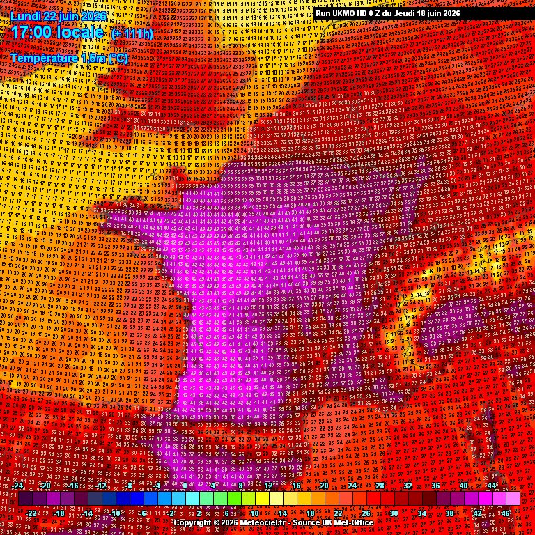
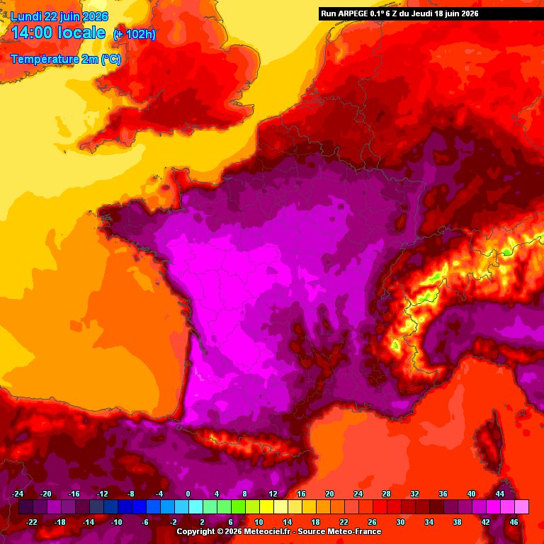
Restons prudents, mais il semble que le scénario extrême l’emporte, avec une #canicule qui dure encore toute la semaine qui arrive (au moins), et des températures exceptionnelles sur de nombreuses régions entre lundi et mercredi (39 à 43°C). À confirmer, mais très inquiétant…


Français

Si vous deviez choisir un joueur dont le but vous procurera le plus d'émotion ce serait qui?
Saka qui ouvre le score franchement ça veut pas sortir de ma tête
Français
Grand prix de Formule 1 au Canada. Le public en doudoune dans le stadium. Quand il fait chaud à un endroit, cela gèle dans un autre. C'est le climat. Rien à voir avec le petit CO2.
Français
Français

🗨️ @PascalPraud tacle @julienbellver (#Quotidien) : « Ils ont été obligés d’agrandir les portes du studio parce que sa tête ne passait plus » #HDPros @CNEWS
Français
Scénario de vague de froid incroyable selon le modèle GFS. Ces derniers temps, les modèles météorologiques ont présenté de nombreux scénarios extrêmes, voire historiques. Bien sûr, rien ne garantit qu'un événement de cette ampleur se produira, mais nous entrons indéniablement dans une période particulièrement intéressante concernant une éventuelle intrusion d'une masse d'air sibérienne en Europe.
Principales incertitudes :
• Gravité
• Jusqu'où ira-t-il vers l'ouest ?
La zone de basse pression persistante venant de l'Atlantique (appelée « Peste de l'Ouest ») jouera un rôle dans le comportement de cette masse d'air froid lorsqu'elle approchera de l'Europe depuis la Sibérie.
Alors qu'une période d'influence occidentale atténuée pourrait permettre une vague de froid plus sévère et prolongée, une activité plus persistante venant de l'ouest pourrait maintenir l'air froid emprisonné dans le nord et l'est.
Des facteurs apparemment insignifiants, qui précèdent cet événement, auront un impact considérable, le transformant d'une simple vague de froid hivernale en un événement historique. Restez vigilants et informés
Weather Watcher@WXWatcher07
Unbelievable cold wave scenario off the GFS. We’ve been seeing a whole lot of insane and potentially historic scenarios on the weather models recently, definitely not saying something of this magnitude will occur, but we are undoubtedly entering a HIGHLY interesting period for a Siberian airmass intrusion into Europe. Main uncertainties: • Severity • How far west will it go The Pest from the West (aka persistent low pressure coming off the Atlantic) will play a role in how this cold airmass behaves as it approaches Europe from Siberia. While a period of muted westerly influence could allow for a more severe and prolonged cold snap, more persistent activity from the west could keep the cold air locked up in the north and east. Seemingly small and insignificant factors leading up to this event will have a profound effect on just another average winter cold snap or something making a run at history books. Stay alert and informed!
Français
🇺🇳 ALLÔ, LE GIEC ?!
Près de 80% du continent européen est couvert de neige, est-ce à cause du CO2... ?

Français
@silvano_trotta Froid glacial sans de vague de froid, même à Strasbourg.
L'escroc du climat dans toute sa splendeur.
Français
Une grande partie de l'Europe a connu un froid glacial cette semaine, mais un changement important est prévu dès demain avec l'arrivée d'air plus doux. L'air sera plus frais, mais moins froid que par le passé dans certaines régions. Dimanche, en Irlande, le temps sera pluvieux et venteux, avec des températures pouvant atteindre 11 °C.
Les escrocs du climat vont pouvoir hurler à nouveau...
Carlow Weather@CarlowWeather
Much of Europe has been in the freezer this week but a big change is coming with milder air moving from from tomorrow. Cooler air will return but not as cold as many parts have been. Turning wet and windy here in Ireland for Sunday but up to 11c.
Français