Sabitlenmiş Tweet
Automated Tampa Bay Weather
1.2K posts


#WPC issues MPD 693 concerning HEAVY RAINFALL...FLASH FLOODING LIKELY: CENTRAL NC wpc.ncep.noaa.gov/metwatch/metwa…
English

#WPC issues MPD 694 concerning HEAVY RAINFALL...FLASH FLOODING LIKELY: PORTIONS OF THE SOUTHERN APPALACHIANS AND SOUTHERN MID-ATLANTIC wpc.ncep.noaa.gov/metwatch/metwa…
English

At 9:30 PM EDT, 1 W Tampa International [Hillsborough Co, FL] Mesonet reports Tstm Wnd Gst of M45 MPH. Mesonet station 1829W FSWN Tampa Intl Apt. #flwx mesonet.agron.iastate.edu/lsr/?by=wfo&wf…

English

A STRONG THUNDERSTORM WILL IMPACT SOUTHWESTERN PASCONORTH CENTRAL PINELLAS AND NORTHWESTERN HILLSBOROUGH COUNTIES THROUGH 930 PM EDT [wind: 40 MPH, hail: 0.00 IN] for Coastal Hillsborough, Coastal Pasco, Inland Hillsborough, Inland Pasco, Pinellas [FL] mesonet.agron.iastate.edu/p.php?pid=2026…

English

#WPC issues MPD 690 concerning HEAVY RAINFALL...FLASH FLOODING LIKELY: EASTERN TENNESSEE wpc.ncep.noaa.gov/metwatch/metwa…
English

🌍 No, that's not smoke. No, it's not chemicals.
What you're looking at is a plume of Saharan dust that traveled over 5,000 miles from the Sahara Desert across the Atlantic and into the Gulf of Mexico. This happens naturally every summer thanks to strong easterly trade winds.
Besides creating some incredible sunrises and sunsets, the dust can make skies look hazy, reduce air quality a bit for sensitive groups, and even help suppress tropical development by bringing drier, more stable air into parts of the Atlantic.
Every year, social media claims this is something new or man-made. It isn't. Forecasters have been tracking Saharan dust events with weather satellites for decades, and they're a completely normal part of Earth's atmosphere.
Science is pretty cool when you realize a desert in Africa can influence weather thousands of miles away. 🌎
English

#TBW issues Area Forecast Discussion (AFD) at Jul 12, 7:49 PM EDT ...New UPDATE, AVIATION... mesonet.agron.iastate.edu/p.php?pid=2026…
English

#WPC issues MPD 689 concerning HEAVY RAINFALL...FLASH FLOODING POSSIBLE: CENTRAL NORTH CAROLINA AND VICINITY wpc.ncep.noaa.gov/metwatch/metwa…
English

#SPC issues MCD 1609 concerning SEVERE THUNDERSTORM WATCH 487 [Most Prob: Gust: 65-80 MPH]: PORTIONS OF CENTRAL AND SOUTHERN ARIZONA spc.noaa.gov/products/md/20…
English

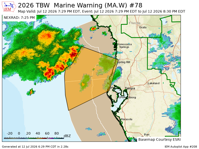
TBW issues Marine Warning [wind: >34 KTS, hail: 0.00 IN] till Jul 12, 8:30 PM EDT mesonet.agron.iastate.edu/vtec/f/2026-O-…

English

#NHC issues Tropical Weather Outlook (TWO) at Jul 12, 5:00 PM PDT mesonet.agron.iastate.edu/p.php?pid=2026…
English

#NHC issues Tropical Weather Outlook (TWO) at Jul 12, 8:00 PM EDT mesonet.agron.iastate.edu/p.php?pid=2026…
English

#SPC issues Severe Thunderstorm Watch 487 till 4:00Z spc.noaa.gov/products/watch…
English

#SPC issues MCD 1607 concerning SEVERE THUNDERSTORM WATCH 486 [Most Prob: Gust: UP TO 60 MPH]: PORTIONS OF CENTRAL/EASTERN GEORGIA INTO CENTRAL SOUTH CAROLINA spc.noaa.gov/products/md/20…
English

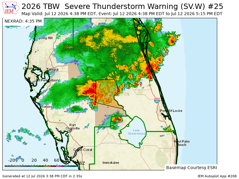
TBW issues Severe Thunderstorm Warning [wind: 60 MPH (RADAR INDICATED), hail: <.75 IN (RADAR INDICATED)] for Highlands, Polk [FL] till 5:15 PM EDT mesonet.agron.iastate.edu/vtec/f/2026-O-…

English

The Weather Prediction Center issues Day 5 Excessive Rainfall Outlook (Max Risk: Slight) at Jul 12, 19:32z wpc.ncep.noaa.gov/qpf/excessive_…

English

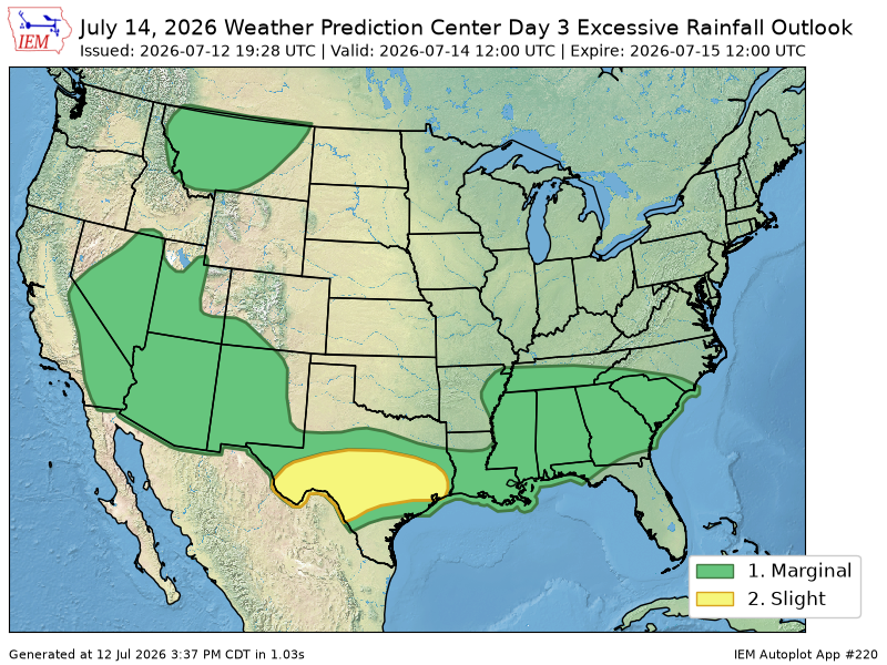
The Weather Prediction Center issues Day 3 Excessive Rainfall Outlook (Max Risk: Slight) at Jul 12, 19:28z wpc.ncep.noaa.gov/qpf/excessive_…

English

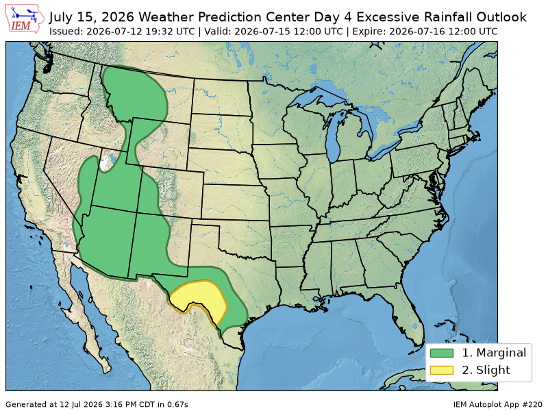
The Weather Prediction Center issues Day 4 Excessive Rainfall Outlook (Max Risk: Slight) at Jul 12, 19:32z wpc.ncep.noaa.gov/qpf/excessive_…

English

#WPC issues MPD 687 concerning HEAVY RAINFALL...FLASH FLOODING POSSIBLE: SOUTHWESTERN ARKANSAS, FAR SOUTHEASTERN OKLAHOMA, NORTHWESTERN LOUISIANA, FAR NORTHEAST TEXAS wpc.ncep.noaa.gov/metwatch/metwa…
English

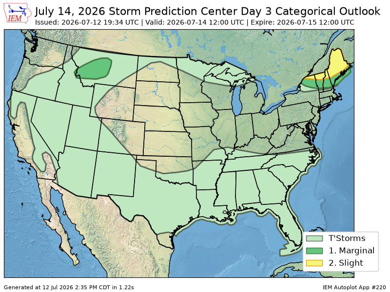
The Storm Prediction Center issues Day 3 Convective Outlook (Max Risk: Slight) at Jul 12, 19:34z spc.noaa.gov/products/outlo…

English