Craig Ceecee, Ph.D.

85.2K posts

Craig Ceecee, Ph.D. banner
Craig Ceecee, Ph.D.

Craig Ceecee, Ph.D.

@CC_StormWatch

Meteorologist (from @msstate x2) focused on tornado protection, founder of Find Your Tornado Shelter LLC. @nwas and @ametsoc member. #STEM advocate. Mark 9:23.

Mississippi Katılım Nisan 2017
21.9K Takip Edilen25.9K Takipçiler
Sabitlenmiş Tweet
Craig Ceecee, Ph.D.
Craig Ceecee, Ph.D.@CC_StormWatch·
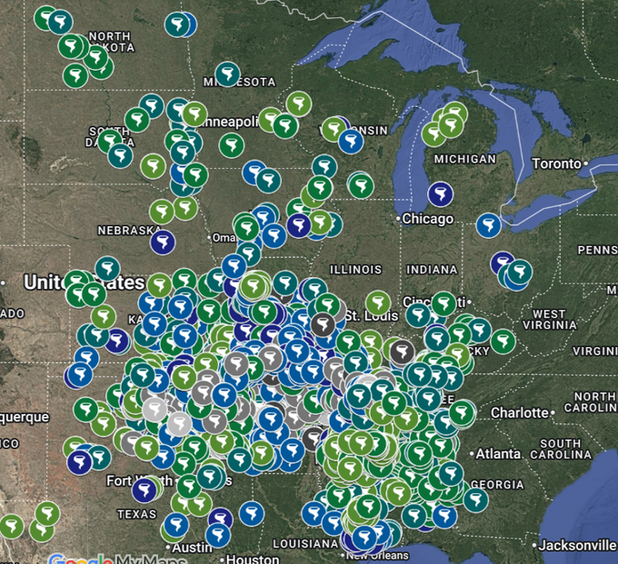
As we enter spring and peak #tornado season, tornado shelter locations continue to be added. The map is at findyourtornadoshelter.com. Share it to your friends, family members and followers so they know where the locations are if they need them. They have been proven to save lives.
Craig Ceecee, Ph.D. tweet media
English
7
47
117
36.8K
Craig Ceecee, Ph.D.
Craig Ceecee, Ph.D.@CC_StormWatch·
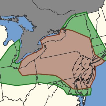
A #tornado watch is now in effect for much of New Jersey, eastern Pennsylvania, eastern Maryland and Delaware. Storms are moving east into the region and a few tornadoes are possible, along with damaging winds. #DEwx #MDwx #PAwx #NJwx
Craig Ceecee, Ph.D. tweet media
English
0
5
13
1.2K
Craig Ceecee, Ph.D.
Craig Ceecee, Ph.D.@CC_StormWatch·
A #tornado watch is likely soon for the Mid-Atlantic. Storms in the Piedmont are rapidly intensifying and a tornado threat will likely evolve from northern VA through DC, MD, DE, southeast PA and NJ. A strong tornado can't be ruled out - especially further east.
Craig Ceecee, Ph.D. tweet media
English
0
6
33
2.6K
Craig Ceecee, Ph.D.
Craig Ceecee, Ph.D.@CC_StormWatch·
@JaniceDean I still have that book. I'd love to see you get back into more writing! (BTW I am working on a book right now)
English
0
0
2
146
Janice Dean
Janice Dean@JaniceDean·
I wrote a book about my life called #MostlySunny 6 years ago. I wish I had waited because little did I know there were more important chapters ahead of me, and the battles got much harder to fight.
Janice Dean tweet media
English
142
97
1.8K
22.4K
Christina Pivirotto
Christina Pivirotto@ChristinaPivir1·
@CC_StormWatch Do storm clouds supersede the smoke haze? Or will a storm pop up and we don’t see the storm clouds because the smoke is blocking them?
English
1
0
0
25
Craig Ceecee, Ph.D.
Craig Ceecee, Ph.D.@CC_StormWatch·
Saturday is setting up to be a busy day in the Northeast for severe weather. That said, the smoke does add a wrench. It could either prevent storm development due to lower instability, or possibly encourage supercells over linear due to EML presence. A real unknown.
English
2
4
33
2.1K
Craig Ceecee, Ph.D.
Craig Ceecee, Ph.D.@CC_StormWatch·
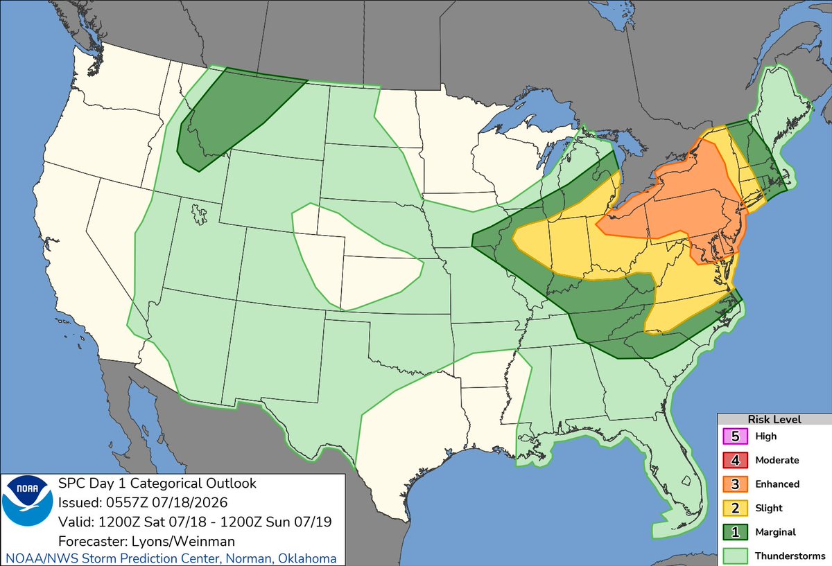
The SPC has maintained a pretty significant threat for Saturday in the Northeast and Mid-Atlantic. The highest #tornado threat looks to be in the NYC to Philadelphia corridor, where a strong tornado cannot be ruled out. Widespread damaging winds are also likely.
Craig Ceecee, Ph.D. tweet mediaCraig Ceecee, Ph.D. tweet mediaCraig Ceecee, Ph.D. tweet media
English
0
12
60
6.1K
Craig Ceecee, Ph.D.
Craig Ceecee, Ph.D.@CC_StormWatch·
It's days like this that make me second guess why I even bothered to complete a Ph.D. in meteorology and whether I should change course...
English
11
1
69
9.7K
Zach Breyan
Zach Breyan@ZachZbreyan·
Have a look at the forecasted sounding for Central Jersey tomorrow. Yikes.
Zach Breyan tweet media
English
1
0
0
250
Craig Ceecee, Ph.D.
Craig Ceecee, Ph.D.@CC_StormWatch·
Speaking of wildfires, a couple weeks ago, I submitted an article on sheltering in them and potential future opportunities. One issue, especially in the West, is that many communities have one road which can close and strand residents and visitors. It could provide a way forward.
English
1
3
10
1.3K
Craig Ceecee, Ph.D.
Craig Ceecee, Ph.D.@CC_StormWatch·
To put it in perspective, if you have read (or actually remember) how bad the air quality was in Los Angeles in the 1980s due to the smog, the air quality in the Great Lakes today was as bad as - or worse than - the worst days they experienced (AQI 300-600 at worst). #wildfires
English
6
6
65
3.8K
Craig Ceecee, Ph.D. retweetledi
Colin McCarthy
Colin McCarthy@US_Stormwatch·
The wildfire situation across North America just got worse. Tens of thousands of lightning strikes across the Pacific Northwest has ignited dozens of new wildfires across Oregon and Washington.
English
42
363
1.1K
72.6K
Craig Ceecee, Ph.D.
Craig Ceecee, Ph.D.@CC_StormWatch·
If only there was a way to control and slow down wildfires in such remote areas. Where they are burning from, in many cases, are many miles from the nearest road. Boreal forests, along with Mediterranean forests (like in California), are the most vulnerable areas for wildfires.
English
1
1
15
1.1K
Kaitlyn Sheehan
Kaitlyn Sheehan@MoffettKaitlyn·
A one two punch this afternoon with thick smoke impcating our air quality and the heat/humidity. Take it easy and limit your time outdoors. Smoke will continue across the region into Friday.
Kaitlyn Sheehan tweet mediaKaitlyn Sheehan tweet mediaKaitlyn Sheehan tweet media
English
2
1
3
403
Laura Haines
Laura Haines@Haines4Laura·
@CC_StormWatch Good thing Camp Mystic closed. Too many have ignorantly assumed this kind of flooding would not happen again. It has. And it's likely to continue.
English
1
0
0
58
Craig Ceecee, Ph.D. retweetledi
MyRadar Weather
MyRadar Weather@MyRadarWX·
BREAKING: The Guadalupe River in Texas has spiked 190-fold in THREE HOURS! CATASTROPHIC flooding ongoing once again in Texas Hill Country along I-10, especially near Kerrville! An obscene stat: At 5 a.m., it would have taken the Guadalupe River 1 minute 24 seconds to fill up an Olympic-sized swimming pool. Now it could fill 2.25 EVERY SECOND. This is where the Guadalupe River passes through Comfort, Texas. Some folks are pushing 15-20+ inches of rain since Tuesday, and all that water is being funneled downhill and flowing into only a few rivers. Multiple FLASH FLOOD EMERGENCIES are in effect. The Weather Prediction Center has drawn a rare HIGH RISK of flash flooding and excessive rainfall. High risks are only drawn 4 percent of the time, but account for 80 percent of all flood-related financial losses and 36 percent of fatalities! A slow-moving and, at times, stalled frontal boundary has been gradually sagging southward for days. Weak low pressure over Mexico induced light southerly winds that have been pumping Gulf moisture northwards. That moisture continues to pool along the frontal boundary, leading to torrential downpours with 2 to 3 inch per hour rainfall rates. Weak winds aloft, meanwhile, mean individual thunderstorms are hardly moving. That's allowed storms to train, or move repeatedly over the same areas. Moreover, a pair of MCVs, or mesoscale convective vortices – broad, weak swirls of wind left behind by since-decayed earlier thunderstorms – are helping to ignite new convection, or thunderstorm activity. That's served to focus the heaviest thunderstorms in a few concentrated zones. On Thursday morning, one MCV was located in Snyder, between Lubbock and Abilene, Tex. The other was near Sonora, or along Interstate 10 about 100 miles north-northwest of Uvalde.
MyRadar Weather tweet media
English
11
75
326
24K
Monica
Monica@cantu_loera·
@CC_StormWatch I'm not here to ask you to buy from my list, but a repost of my pinned post would be awesome!
English
1
0
1
10