Carmel Valley River
134 posts
Carmel Valley River
@CVR_G16
Hyperlocal journalism for Carmel Valley Village in Monterey County. #cvrg16
Carmel Valley Village, CA Katılım Ağustos 2016
15 Takip Edilen54 Takipçiler

Carmel Valley River retweetledi

#MillFire holding at 310 acres & 50% containment. Crews will continue reinforcing line & snuffing out hotspots within the perimeter. Air resources based at the Fort Hunter Liggett helibase are available to support crews on the ground until the fire is declared OUT.
English
Big Sur Kate writes the community is giving the #MillFire response an A+, and she's thanking the incident commanders. #cvrg16
bigsurkate@bigsurkate
Mill Fire, Day 5, 8/3/19 bigsurkate.blog/2019/08/03/mil…
English
Historically, the 2008 Basin Complex fire was 162,818 acres, and the 1977 Marble Cone fire was 178,000 acres.
English
Contrast 300 acres to 2016 when the #SoberanesFire on Day 18 was 60,400 acres but still only 45% contained.
It would eventually last 82 days and burn 132,127 acres, the third largest fire in Monterey County.
English
The Herald's clickbait teaser sounds like the #MillFire threat is building when the official report from @inciweb is the opposite, including the phrase "Good recovery," which never makes it into their article. #cvrg16
Monterey Herald@MontereyHerald
Mill Fire in Monterey County burns almost 300 acres, sees little containment trib.al/Do9jGpx
English
8/2 11 a.m. #MillFire significant events: "Fire behavior declined after midnight. Activity on the line decreased. Good recovery." Estimated containment date still Monday. #cvrg16
InciWeb@inciweb
#MillFire #CA #CALPF bit.ly/2YHgQdC Mill Fire: The Mill Fire was reported at 5:36 a.m. on July 30\, 2019 on Mill Creek\, north west
English
Carmel Valley River retweetledi

Carmel Valley River retweetledi


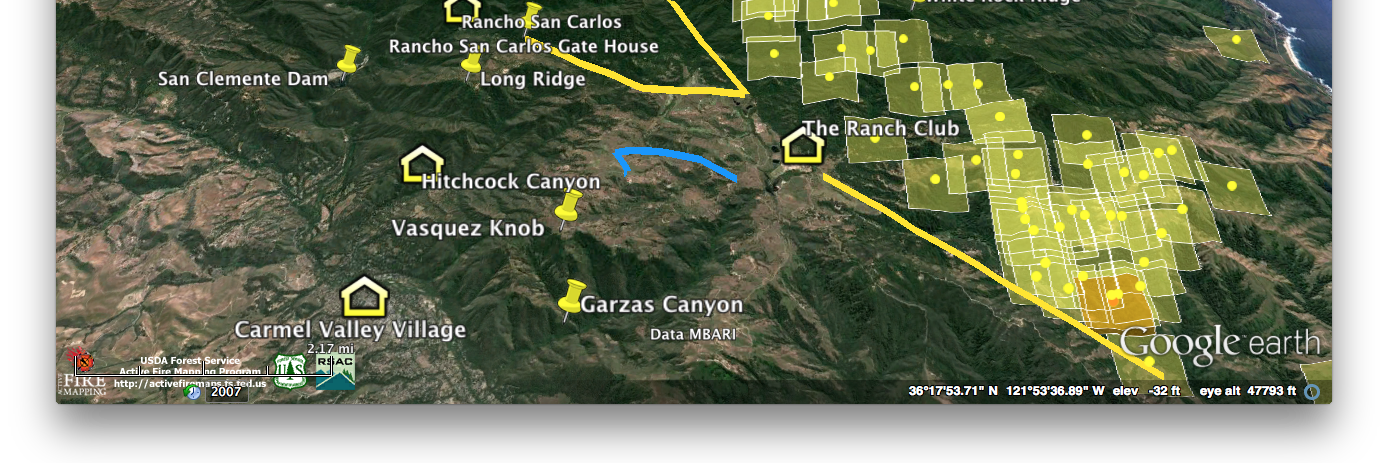
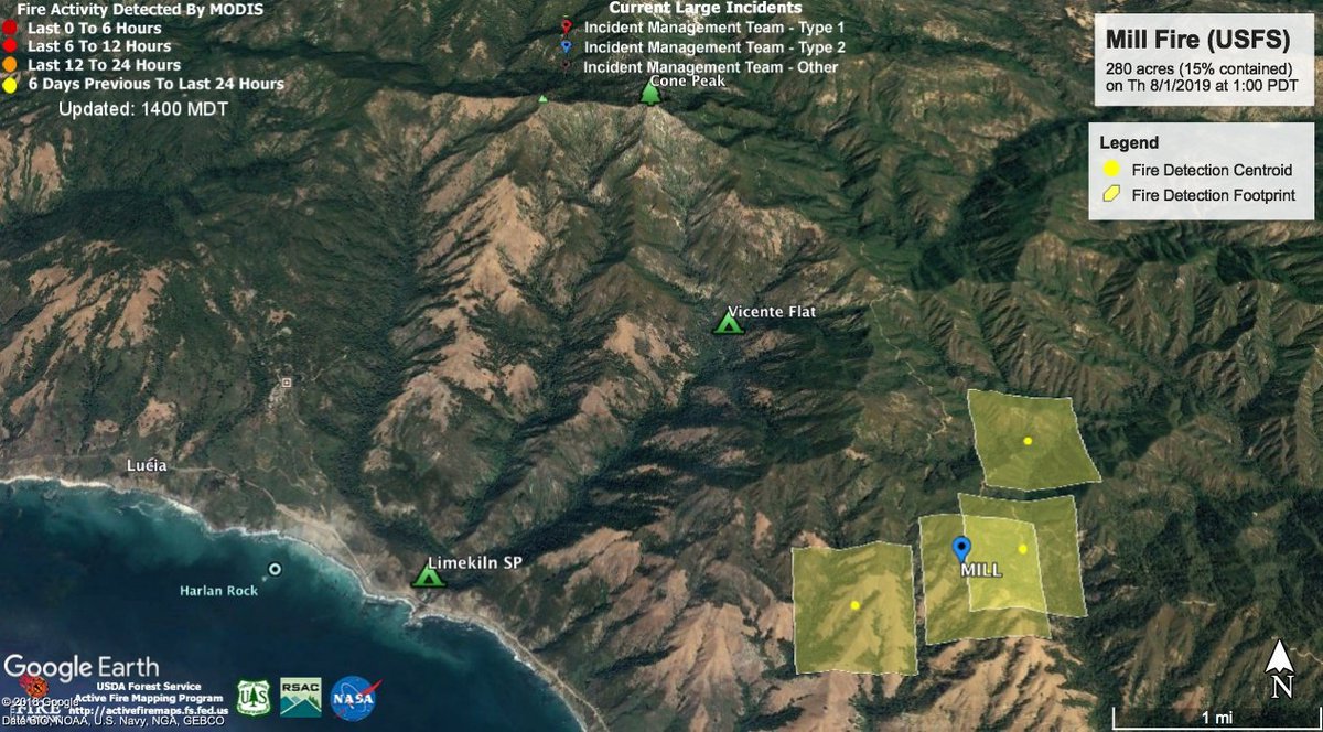
The #MillFire map using Google Earth and MODIS data at 1 p.m. on 8/1/2019. Limekiln State Park remains open but Vicente Flat remains closed. Follow @LosPadresNF for latest fire updates and @ventanawild for trail closures. #cvrg16
English
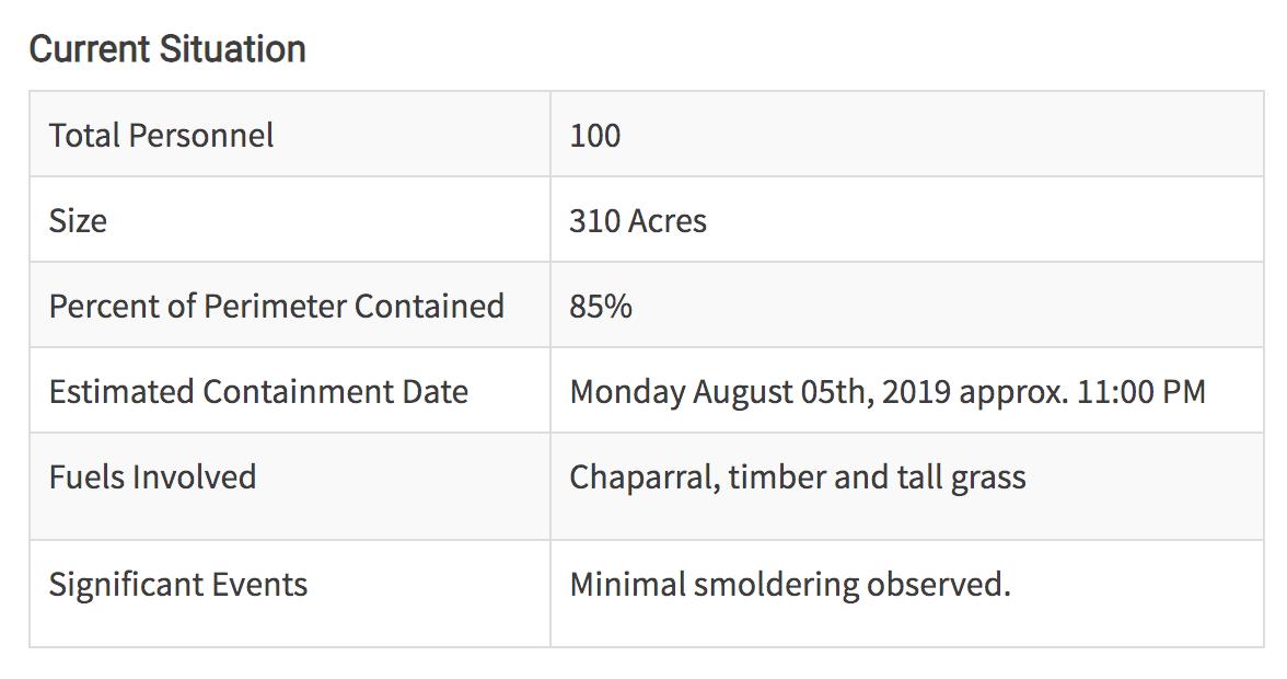
NOTE: Estimated Containment Date has changed to “Monday August 05th, 2019 approx. 11:00 PM.” Previous estimate was tonight 8/1 at 11 p.m. #MillFire #cvrg16
InciWeb@inciweb
#MillFire #CA #CALPF bit.ly/2YHgQdC Mill Fire: The Mill Fire was reported at 5:36 a.m. on July 30\, 2019 on Mill Creek\, north west
English
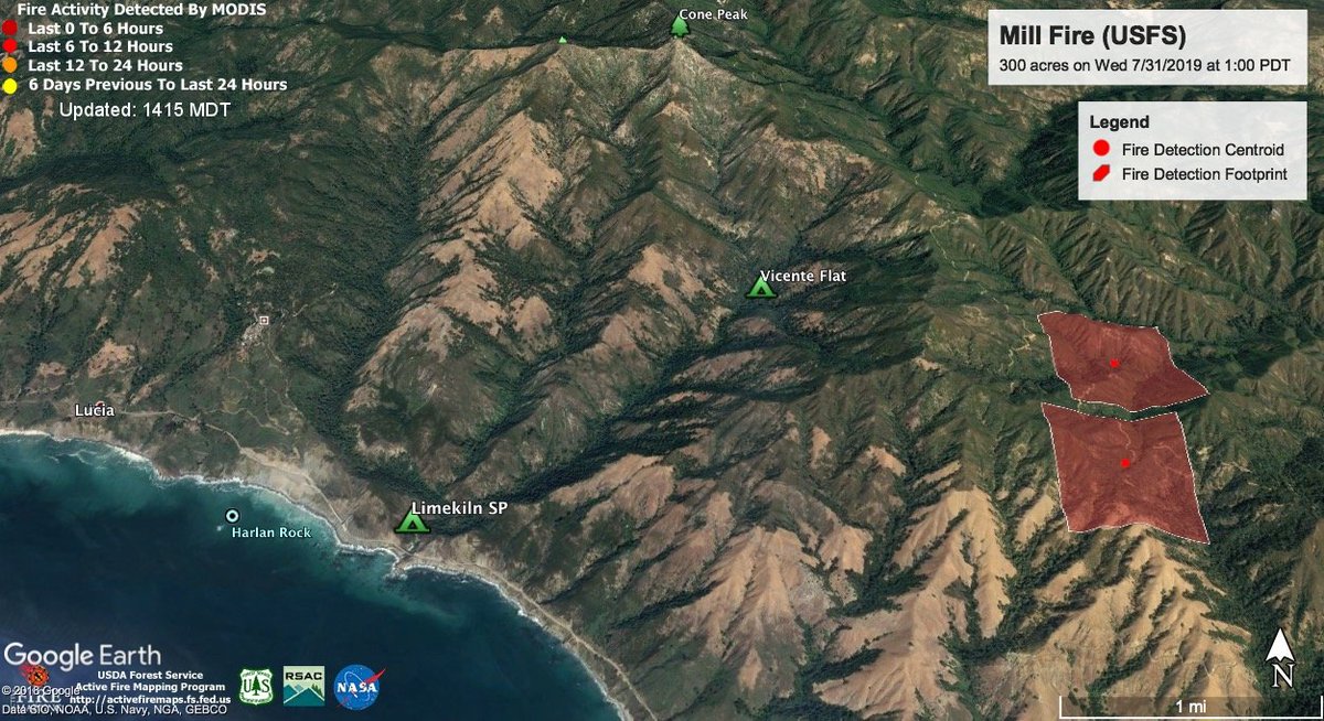
The #MillFire map using Google Earth and MODIS data at 1 p.m. on 7/31/2019. Limekiln State Park remains open but Vicente Flat is closed. Follow @LosPadresNF for latest fire updates and @ventanawild for trail closures. #cvrg16
English
Rain has finally come to the Village & we are that much closer to containing the #SoberanesFire. medium.com/carmel-valley-…
English
Seeing 0.11' at Los Padres Dam but 1.10' on Ponciano Ridge & 2.80' up at White Rock, on the eastern edge of the #SoberanesFire twitter.com/NWSBayArea/sta…
NWS Bay Area 🌉@NWSBayArea
Unofficial Storm Rainfall Reports through 6AM from around the San Francisco Bay and Monterey Bay areas: wrh.noaa.gov/total_forecast… #cawx
English
@CVGrrl @KeithVandevere And Basin Complex was 162K in 2008. Neither crossed into SLO county. Seems a pretty bold statement for a shirt.
English
Shirt for sale at the Village Market. Not so sure about the claim of "largest." Thoughts @KeithVandevere? #cvrg16

English
1 PM: Traffic slows to a crawl at Via Mallorca but opens up past Rancho San Carlos Road. #cvrg16

English