J. Mesh, AMS 🇺🇸@realwxforecast
Followers — I hope all of you are trying to stay cool, because the March 2026 heatwave is now fully underway.
By now, @NWSLosAngeles and nearly every forecast office across #California and the western U.S. have issued heat advisories as a rare — but not unheard of — March heat event builds across the region. A large ridge is dominating the western CONUS, pushing temperatures well above seasonal norms.
The #PNW is sitting on the northern edge of the ridge and should trend closer to normal temps after a fairly active weather week, but most of the West is now firmly under the heat dome.
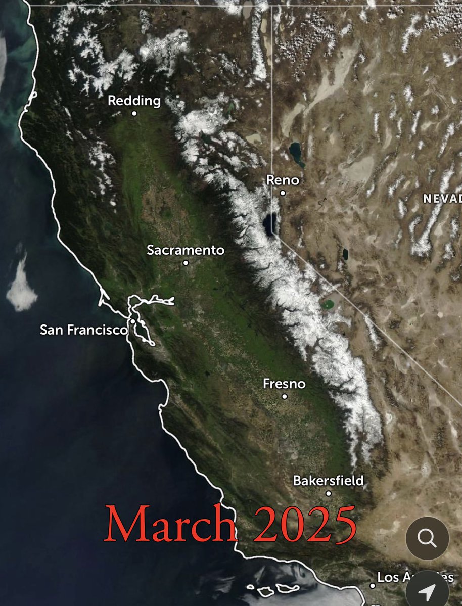
As many of you know, I’ve been in Northern California this past week for business meetings. That gave me the chance to spend several days up in the Sierra around the Tahoe Basin — an area I’ve been visiting since I was a kid and know very well.
Here is my on-the-ground report from Palisades Tahoe and Alpine Meadows.
First, a quick recap.
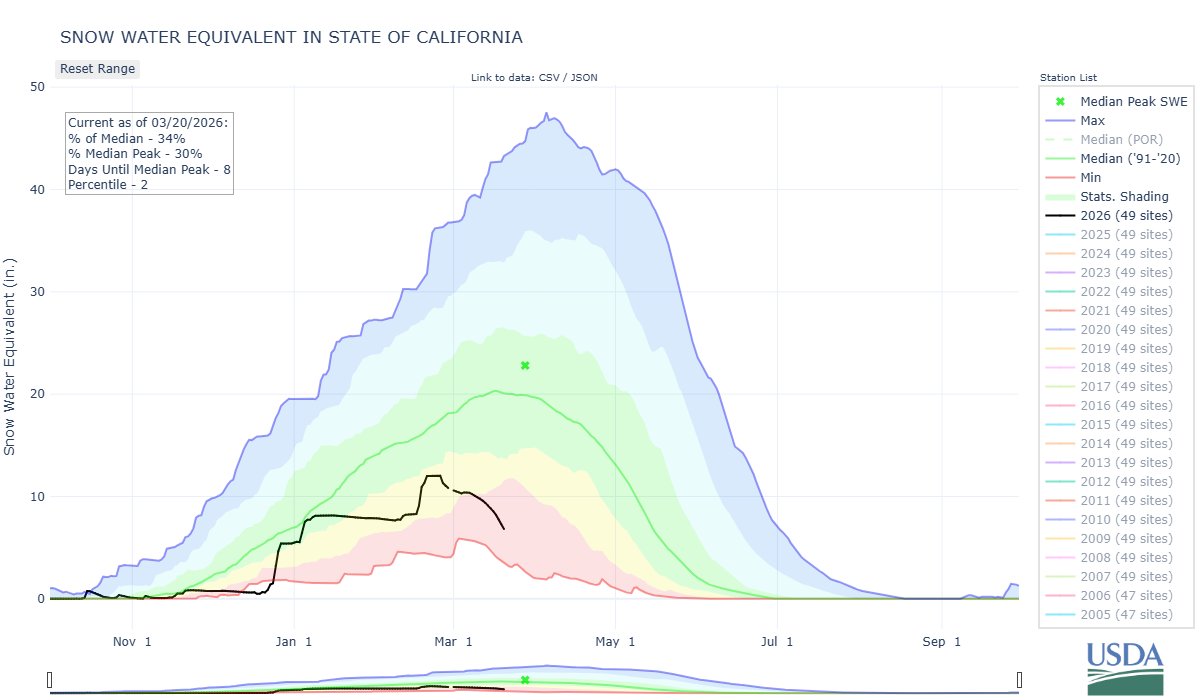
The snowpack at Palisades Tahoe is getting absolutely decimated, and the melt rate is accelerating under the dominant western ridge.
After the ~100" dump around Presidents Week, it briefly looked like the Sierra season had been salvaged. But what followed was brutal for the snowpack.
Several atmospheric river events pushed snow levels into the 9,500–10,000 ft range, bringing widespread rain-on-snow across much of the Tahoe Basin. That saturated and weakened the mid and lower elevation base.
Now we’ve entered the second phase of the damage:
A high-amplitude ridge parked over the western U.S.
From a synoptic standpoint, we’re seeing classic Sierra snowpack destruction signals:
• 594–597 dm 500mb heights building over CA/NV
• Strong subsidence and compressional warming
• Persistent clear skies with intense March solar radiation (sun angle)
• Temperatures running well above normal
Once the snowpack transitions toward isothermal conditions, melt rates accelerate quickly — and that’s exactly what’s happening across the mountain right now.
I spoke with an anonymous source within Palisades Tahoe mountain operations today, and the numbers are staggering.
They told me the mountain is currently losing roughly 3–4 inches of snowpack per day, and with the extreme warmer temperatures arriving tomorrow through the week, that melt rate could accelerate to 6–10 inches per day.
Unreal.
If that verifies, conditions will deteriorate extremely quickly. According to that same source, it may be very difficult to keep the lower half of the mountain open by Friday if this melt rate continues. Coverage across the lower elevations is already deteriorating rapidly.
I skied there for three days — and every day got worse.
The top layer of snow from the late February storm cycle is now completely gone. What remains underneath is a mix of ice, melt, and overnight refreeze.
Spring corn — as they call it.
The situation over at Alpine Meadows is even more telling.
Very little terrain remains open:
• Sherwood, Lakeview, and Scott are now done for the season
• The backside is closed
• Only Roundhouse, Treeline Cirque, and Summit lifts remain operating
And even those areas are seeing rapid snowpack loss. What makes this even more remarkable is the contrast. Two years ago at this exact time I was standing on this same mountain. The base depth was pushing 10 feet, snow showers were moving through the Sierra, and we were seeing intermittent powder cycles roll through Tahoe.
Fast forward to today and we’re looking at temperatures approaching 70°F on the mountain. That is an extraordinary shift in just two seasons. The bigger problem now is the pattern ahead.
I have read reports from @TahoeWeather about Diamond Peak and on his @OpenSnow blog. It truly remarkable about what is going on all over #california, so it is not an exaggeration.
Here are some pictures from the Village at Palisades, picture from Lakeview run, another village, and the huge party at the Olympic House. Fun time!
Long Range:
I know there’s been a lot of chatter on X about a Kona Low near Hawaii eventually ejecting east and impacting the West Coast toward the end of the month.
Folks — I just don’t see it.
The Euro AI guidance and ensemble suites simply aren’t showing any meaningful energy making it into California, with the ridge continuing to dominate the West Coast pattern.
Could that change? Sure.
But as of right now, there’s nothing on the board for California. I will post more images on this thread.....
#CaliforniaHeatwave
#TahoeWeather
#PalisadesTahoe
#SierraSnowpack
#AtmosphericRiver
#HeatDome
#WestCoastWeather
#CAwx
#SierraNevada
#Tahoe
#Climate
#WeatherAnalysis
#CAwx #Tahoe #SierraNevada #Snowpack #HeatDome #WestCoastWx #AtmosphericRiver #KonaLow #LongRangeWx #SkiTwitter