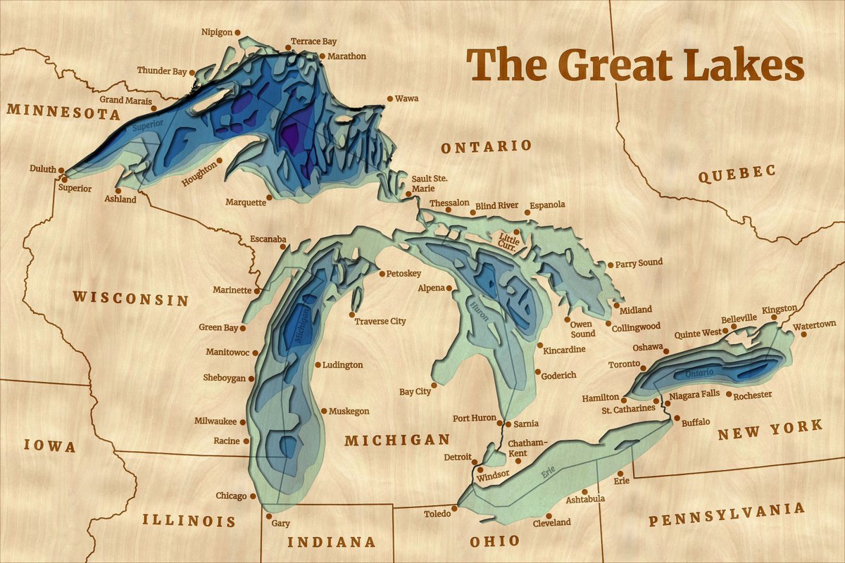
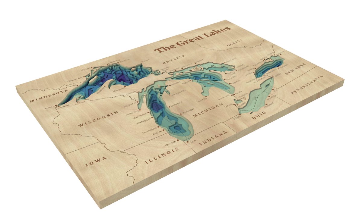
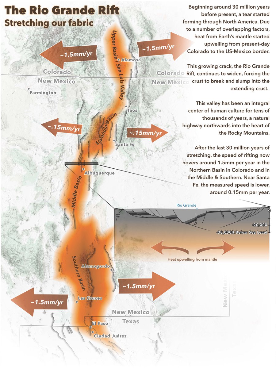
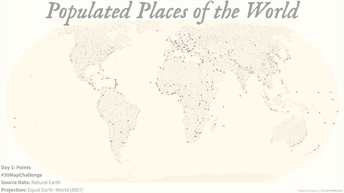
Tommy 🗺️

2.3K posts

Tommy 🗺️ banner
Tommy 🗺️

Tommy 🗺️

@CartoRedux

Cartographer and Principal Technical Consultant @Esri / cache slinger / early adopter / data wrangler / quoter of movies bc I lack original thoughts of my own

New York, NY Katılım Eylül 2017
259 Takip Edilen817 Takipçiler
Sabitlenmiş Tweet
Tommy 🗺️
Tommy 🗺️@CartoRedux·
Daughter dropped some news on me last night: *Dad I told my class I want to make maps when I grow up. Can I make maps like you?* Sweetheart, you will make amazing maps if that’s what you want to do. Buckle up world another #Cartographer on the way. #ProudDaddy #YouGoGirl ❤️
English
2
1
25
0
Kenneth Field
Kenneth Field@kennethfield·
My mapping half-brother @John_M_Nelson and I gave the cassette tape gag one more go at #FedGIS. Sadly, the proportion of folks who don't get it just keeps increasing 🤦🤣
Kenneth Field tweet media
English
1
0
8
481
Tommy 🗺️ retweetledi
ArcGIS Pro
ArcGIS Pro@ArcGISPro·
Five years in Jordan left Jared Kohler fascinated with its rare national flower, the Black Iris. Incorporating ArcGIS Living Atlas iNaturalist + GBIF data in #ArcGISPro, he mapped recorded sightings across the country. #30DayMapChallenge day 28: ow.ly/ZCBq50Xz8mw
ArcGIS Pro tweet media
English
0
2
27
1.5K
Tommy 🗺️
Tommy 🗺️@CartoRedux·
@Scott_ODonnell @ArcGISPro Thanks Scott. They did take a bit of work to get just right. I used #Arcade to pad the shield number to get a more consistent shield width. I paired that with the label class - point symbol callout scaling of "width only" to achieve the effect I was after.
Tommy 🗺️ tweet mediaTommy 🗺️ tweet mediaTommy 🗺️ tweet media
English
0
0
1
10
Scott O
Scott O@Scott_ODonnell·
@ArcGISPro Those shields are great. I have always had a tough time with getting them just right.
English
1
0
1
42
Tommy 🗺️ retweetledi
ArcGIS Pro
ArcGIS Pro@ArcGISPro·
Tommy Fauvell built a road map of the U.S. AND a reusable #ArcGISPro project to help you fully leverage the Natural Earth public domain map dataset. Explore it for yourself today! #30DayMapChallenge day 22: ow.ly/rkou50XwgvM
ArcGIS Pro tweet mediaArcGIS Pro tweet media
English
2
4
20
1.9K
Tommy 🗺️ retweetledi
ArcGIS Pro
ArcGIS Pro@ArcGISPro·
That’s a wrap on the #30DayMapChallenge week 3! This week, the #ArcGISPro Team showcased the keystone role prairie dogs play in shaping ecosystems, projected… projections, explored the many ways trees are stylized in @Esri basemaps +more! Get a recap here:ow.ly/qevO50XvZWU
GIF
English
1
5
35
1.7K
Tommy 🗺️ retweetledi
ArcGIS Pro
ArcGIS Pro@ArcGISPro·
From forests to trees, features are uniquely visualized across the different @Esri basemaps. Using #ArcGISPro, Cindy Prostak mapped ways trees are symbolized. 🌳Take a “walk” and marvel at the distinctive foliage.🚶‍♀️ #30DayMapChallenge day 21: ow.ly/mRQL50XvNVZ
ArcGIS Pro tweet media
English
0
10
50
1.9K
Tommy 🗺️ retweetledi
ArcGIS Pro
ArcGIS Pro@ArcGISPro·
🌊 Wooden lake maps are a classic Midwest cabin decor, often showing bathymetry in thin layers of wood. 🪵 Noel Peterson crafted 2D &3D digital representations of these in #ArcGISPro! Check out day 20 of the #30DayMapChallenge: ow.ly/irNB50XuMBX
ArcGIS Pro tweet mediaArcGIS Pro tweet media
English
0
13
57
2.1K
Tommy 🗺️ retweetledi
ArcGIS Pro
ArcGIS Pro@ArcGISPro·
Map accessibility conversations often stop at contrast ratios and text sizes. Jakob Ruffner created this Rio Grande Rift map to demonstrate that the key is to consider every aspect of the map design process. Check out day 7 of the #30DayMapChallenge: ow.ly/VU1X50Xo6wa
ArcGIS Pro tweet media
English
1
13
82
2.8K
John Nelson
John Nelson@John_M_Nelson·
As I was editing just now I thought it would be fun to reverse the content and show only what I edit out.
English
2
0
10
1.7K
Tommy 🗺️
Tommy 🗺️@CartoRedux·
@John_M_Nelson Ooops! Gotta love those moments when annoying co-workers bug you in the middle of doing something cool! 😳
English
1
0
1
150
John Nelson
John Nelson@John_M_Nelson·
Starting a new project, mapping a portion of the Red Cedar River. OSM river polygons as starter reference, adding detail via "streaming" line edit with Living Atlas basemap imagery and NAIP as visual reference.
English
3
3
83
5K
Mobajo
Mobajo@mobadghon·
@CartoRedux The colors sit perfectly 👌🏼.. Hey sir tommy , can I message you on something you explained on “caching “ ?
English
1
0
0
12
Tommy 🗺️
Tommy 🗺️@CartoRedux·
Goodies arrived just in time! I didn’t think they made bottles this tall and thin @kennethfield 🍻
Tommy 🗺️ tweet media
English
1
0
1
257
Tommy 🗺️
Tommy 🗺️@CartoRedux·
@saellenson Hi Shira! Certainly on my list of to-do's for a more detailed how-to on this topic. Email inbound to chat further 👍🏻
English
0
0
0
4
Shira Ellenson
Shira Ellenson@saellenson·
@CartoRedux Hey Tommy! I had some follow up questions regarding adding custom fonts in the tile style editor... would love if you could shoot me a message and we could discuss this more! sae52@cornell.edu
English
1
0
1
18
Kenneth Field
Kenneth Field@kennethfield·
Experimenting changing the following line symbol designs to show less frequent services (increased wait times) by route segment: Size (width) Transparency Transparency AND size overlay Dashed lines Thoughts? Other options?
Kenneth Field tweet mediaKenneth Field tweet mediaKenneth Field tweet mediaKenneth Field tweet media
English
4
2
8
1.9K
Tommy 🗺️
Tommy 🗺️@CartoRedux·
I love making digital maps. But there’s just something special about being able to hold a map. The feel of it, the smell of the ink…
Tommy 🗺️ tweet mediaTommy 🗺️ tweet mediaTommy 🗺️ tweet media
English
2
1
7
1.3K