Chad Crilley

5.2K posts

Chad Crilley banner
Chad Crilley

Chad Crilley

@ChadCWX

independent Broadcast Meteorologist/Professional Storm Chaser 🌪️Former Chief Meteorologist 📺 San Diego Boy at Heart 🌴

Austin, TX Katılım Ekim 2012
1.1K Takip Edilen1.8K Takipçiler
Chad Crilley
Chad Crilley@ChadCWX·
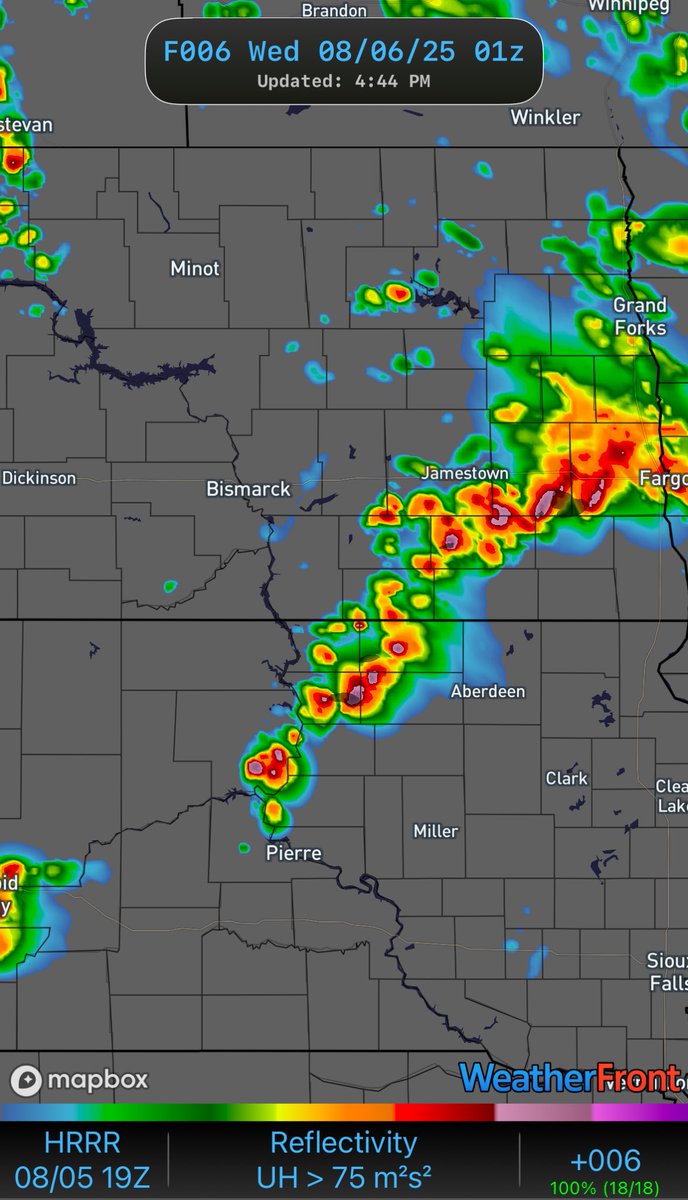
To all the keyboards warriors coming at the SPC for a “poor” forecast. Here’s the explanation you’ve been waiting for. SPC forecasters remain among the very best in the industry!
Ari Sarsalari@AriWeather

Full chat with @NWSSPC's @evan_bentley about what went wrong with Monday's MDT Risk forecast and some of the response from the public.. Amazing talk, Evan was a super cool guy, very transparent and I appreciate the time! Sorry I only got a few of your Qs in.. #wxtwitter

English
0
1
7
475
Chad Crilley retweetledi
Ari Sarsalari
Ari Sarsalari@AriWeather·
Some analysis on what happened to create the (let's be real) *unexpected* deadly Michigan tornado in Union City on Tuesday afternoon. Huge learning experience
English
24
92
663
60.6K
Chad Crilley retweetledi
NWS Weather Prediction Center
The analyzed central pressure at 7 am EST was 966 mb. This is an estimated 41 mb drop in 24 hours compared to yesterday's analysis at the same of 1007 mb.
NWS Weather Prediction Center tweet media
NWS Weather Prediction Center@NWSWPC

Morning satellite loop of the very strong Nor'Easter producing powerful winds and very heavy snow across the Northeast. Blizzard conditions and crippling impacts will continue through much of today for the region. 🛰️❄️

English
11
177
642
138.9K
Chad Crilley
Chad Crilley@ChadCWX·
Monday has the makings of a severe weather day in So Cal. This set up is rare but does happen every so often. A Pacific cold front will move ashore with increasing low-level moisture, a strengthening LLJ, and weak (but present) instability. Look for QLCS type storm mode with damaging gusts and a tornado or two.
Chad Crilley tweet mediaChad Crilley tweet mediaChad Crilley tweet mediaChad Crilley tweet media
English
1
0
0
287
Chad Crilley
Chad Crilley@ChadCWX·
I’m always especially interested in severe weather setups when they occur in areas that don’t typically see severe storms. NWS Los Angeles using particularly strong wording regarding Monday’s severe weather potential in Southern California.
Chad Crilley tweet media
English
0
0
3
339
Chad Crilley
Chad Crilley@ChadCWX·
If I am experiencing information overload about the upcoming winter storm, I know you almost DEFINITELY are too. Check out the Winter Storm Severity Index from WPC. It helps answer the simple question of “how bad will it be where I live” which at the end of the day is probably the question you wanted answered the most.
Chad Crilley tweet media
English
1
3
6
719
Chad Crilley retweetledi
Cameron Nixon
Cameron Nixon@CameronJNixon·
Ever feel like your town gets more nighttime tornadoes than others? Here's a map of tornadoes by time of day (nighttime tors are plotted on top of daytime tors to stand out). I feel for you Tulsa, Jackson, Birmingham, Nashville...
Cameron Nixon tweet media
English
53
134
771
159.2K
Chad Crilley retweetledi
Colin McCarthy
Colin McCarthy@US_Stormwatch·
This footage from inside the eye of Category 5 Hurricane Melissa might be the most jaw-dropping video ever captured of a hurricane’s eye, showcasing the infamous “stadium effect."
English
1.1K
22.3K
152.3K
9.9M
Chad Crilley
Chad Crilley@ChadCWX·
@ATLAreaWx Tons of people in this field are successful without the degree. A lot of times it comes down to how well of a communicator you are.
English
0
0
0
35
Chad Crilley retweetledi
Hurricane Hunters
Hurricane Hunters@53rdWRS·
Last night, the 53rd Weather Reconnaissance Squadron flew into the eye of Hurricane Erin—and captured imagery of the breathtaking stadium effect. These missions provide critical data to the NHC to improve forecasts, helping keep communities safe before the storm makes landfall.#readynow #weatherready
English
178
2.6K
9.9K
1M
Chad Crilley retweetledi
And☈ew G☈iffiths
And☈ew G☈iffiths@Central_IL_Wx·
21z Bismarck, ND sounding reveals a classic Mid-Day Plains profile with a remnant EML being mixed and very strong thermodynamics. Low level shear isnt super strong yet, but a strengthening low and incoming wave from Montana + the warm front further north will help increase shear.
And☈ew G☈iffiths tweet mediaAnd☈ew G☈iffiths tweet media
English
0
7
35
3.8K
Chad Crilley
Chad Crilley@ChadCWX·
Look at the environment not the CAMS sorta day in ND. Storm mode is pretty uncertain up there, but the environment looks supportive of some big hail followed by an overnight wind risk. Any storm rooted along the warm front could produce a tornado, especially if storm mode is supercells at first.
Chad Crilley tweet mediaChad Crilley tweet mediaChad Crilley tweet mediaChad Crilley tweet media
English
0
0
1
540
Chad Crilley
Chad Crilley@ChadCWX·
Daily reminder to be mindful of tweets that show a landfalling major hurricane 10+ days out from ONE model. At a minimum show the ensembles 😩 Also tweeting the run and just saying “not a forecast” in the caption isn’t a work around. What we’re missing is context. Yes, we’ve all seen the EURO AI…but if you’re going to show it, tell us what it means. (hint: it means nothing)
English
0
0
1
353
Chad Crilley
Chad Crilley@ChadCWX·
South Dakota the hot spot for severe weather recently and again tonight. Looks like a pretty ripe environment for tornadoes over the next few hours, especially with supercells developing along a warm front. Look at the warm nose. Probably very photogenic storms too. #sdwx #ndwx
Chad Crilley tweet mediaChad Crilley tweet mediaChad Crilley tweet media
English
0
0
1
411
Chad Crilley
Chad Crilley@ChadCWX·
Like clockwork. It’s always the first big fantasy landfalling storm of the season that seems to grab all the social media attention. Same thing happens at the beginning of severe weather season lol.
English
1
0
4
400
Chad Crilley retweetledi
Breaking 4 News
Breaking 4 News@Breaking_4_News·
BREAKING: Flash flooding in Queens, NYC.
Breaking 4 News tweet media
English
26
222
787
56.7K