Capital Weather Gang@capitalweather
Fair warning: Those wanting a definitive snow forecast for Sunday into early Monday will not be satisfied by this update.
Models have not come to a consensus on how the storm will play out. We can say which way we are leaning and why, which we'll do here. But the bottom line is that as little as an inch or so of nuisance snow, to as much as several inches of more disruptive snow, are both still in play.
We know that's frustrating, but every storm is different, and that's the reality of where we are today in the process of predicting this particular storm.
It's not just the (probably) crazy American GFS model that is making things difficult by predicting more than a foot of snow in the D.C. area (down from 3 feet yesterday). Several other models, all more credible than the GFS, also show a wide range snow accumulations, ranging from no accumulation to around 8 inches.
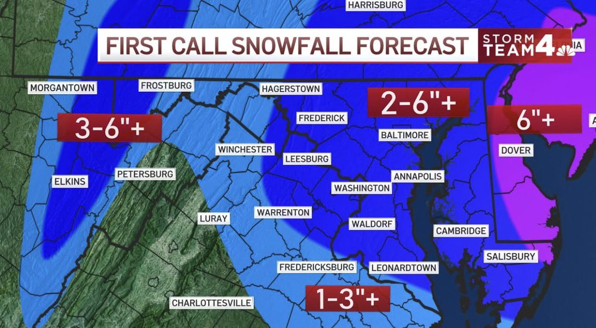
Here's our current thinking for the odds of different snow amounts in the Beltway area:
* Chance of at least 1": 50%
* Chance of at least 3": 35%
* Chance of at least 6": 20%
* Chance of 10" or more: 10%
We lean toward a relatively lighter accumulation of around 1 to 3 inches, mainly Sunday night into early Monday morning. This could lead to some delays and closings Monday. However, we cannot completely dismiss the outside chance that the storm dumps 6 inches of snow on parts of the area.
Here’s how we see the storm timing and details (still subject to change):
* Sunday morning into afternoon: Rain, or a mix of rain and snow, is likely to develop during the morning and continue through afternoon. We lean toward any snow being fairly light with temperatures in the mid-30s or higher, which would limit accumulation during the daylight hours. But we can’t rule out snow becoming heavy enough to drop temperatures closer to freezing and start accumulating, especially on grassy areas, by late afternoon.
* Sunday evening and overnight: Precipitation should change to primarily snow, and accumulating snow becomes more likely as temperatures drop into the low 30s. A period of heavier snow is possible, but if snow remains on the lighter side, then accumulation could be higher on grass than roads.
* Monday: Snow may continue at times during the morning but should trend lighter and probably won’t produce much additional accumulation. Temperatures rise to the upper 30s to near 40 for afternoon highs.
Our forecast rationale:
The forecast challenge boils down to the following: If low pressure developing off the Mid-Atlantic coast Sunday strengthens fast enough and close enough to the coast, drawing cold air southward, it could wallop parts of the area with heavy. wind-blown snow. But if it strengthens more slowly and farther offshore, precipitation — probably a mix of rain and lighter snow — and the associated impacts will be weaker.
Our forecast leans toward a compromise between these scenarios, which is what the European and UK Met models have signaled. Both models have been more consistent the past couple of days than others, and have higher accuracy ratings.
We'll keep you updated.