Justin Rudicel

23.9K posts

Justin Rudicel banner
Justin Rudicel

Justin Rudicel

@ChasingtheMeso

TV Meteorologist for KWTV News 9 (CBS) Oklahoma city. I love my family, weather, football, photography, IndyCar, & chasing storms. https://t.co/WEsn3mlUYD

Oklahoma city, Oklahoma Katılım Şubat 2010
1.3K Takip Edilen6.7K Takipçiler
Justin Rudicel
Justin Rudicel@ChasingtheMeso·
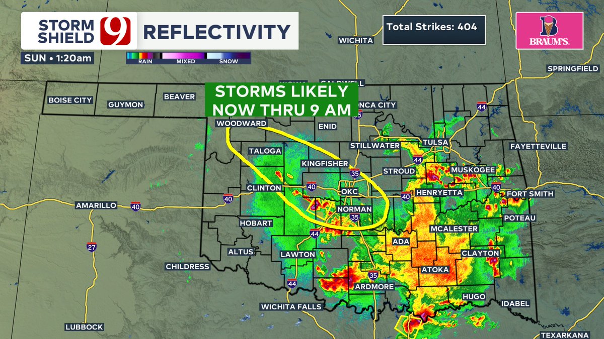
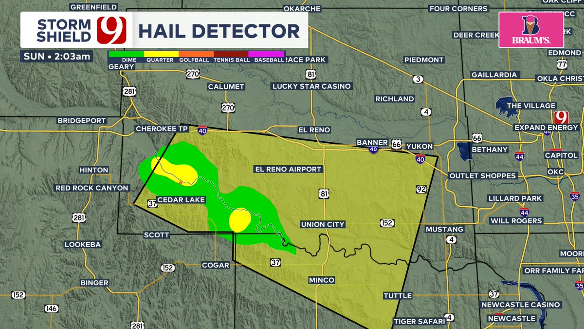
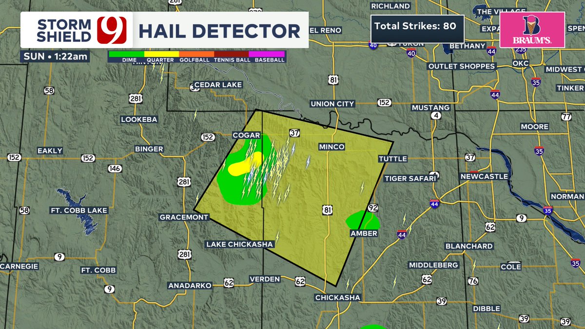
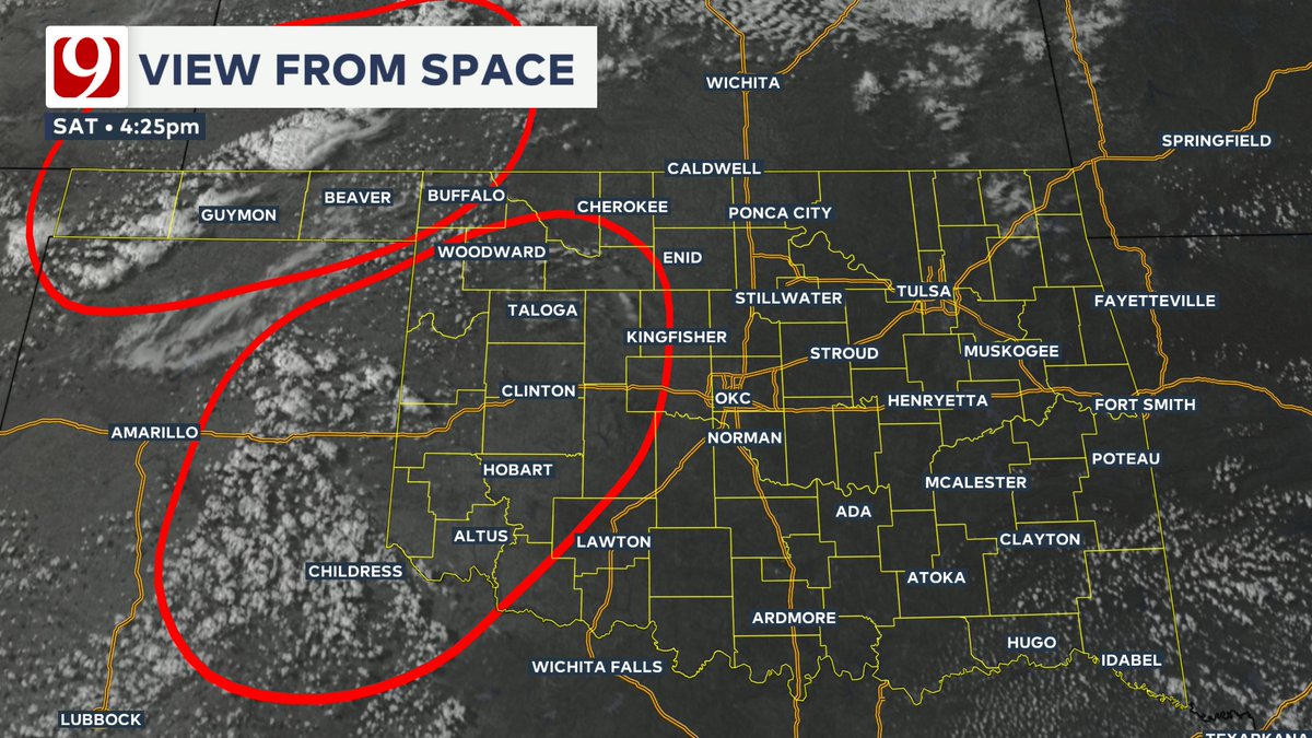
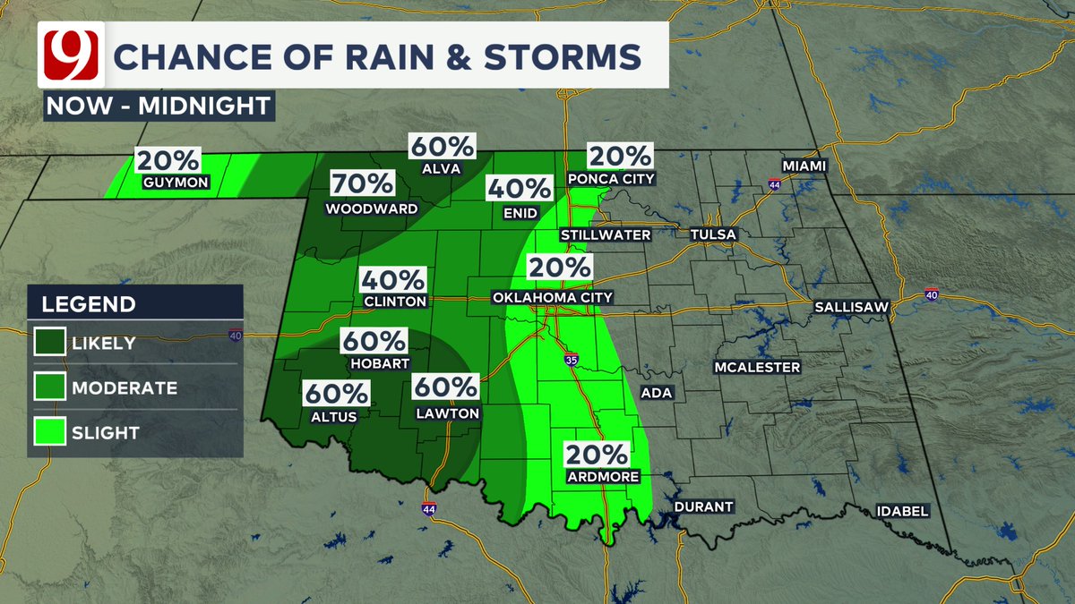
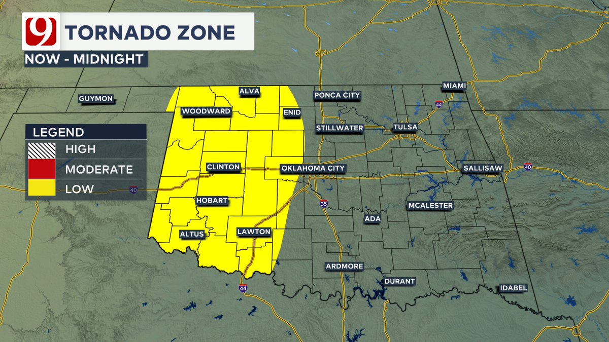
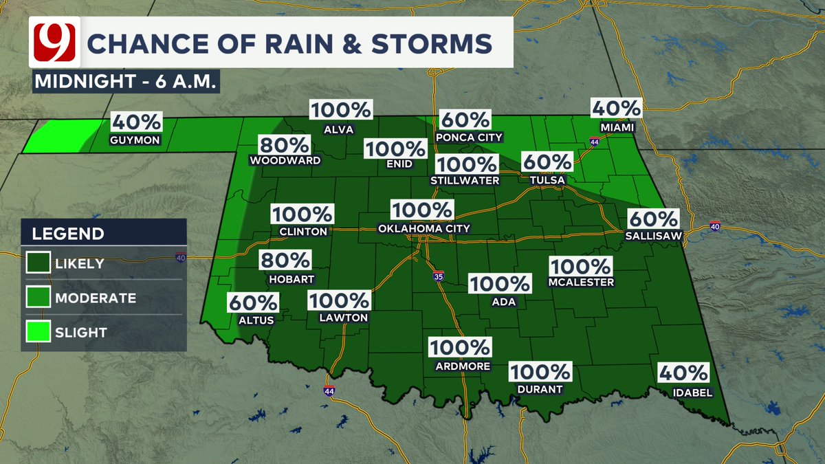
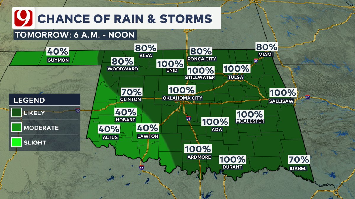
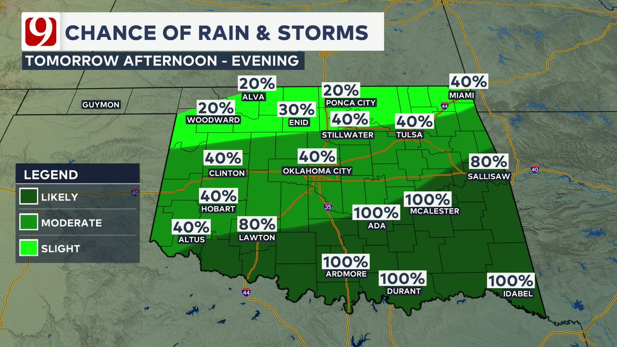
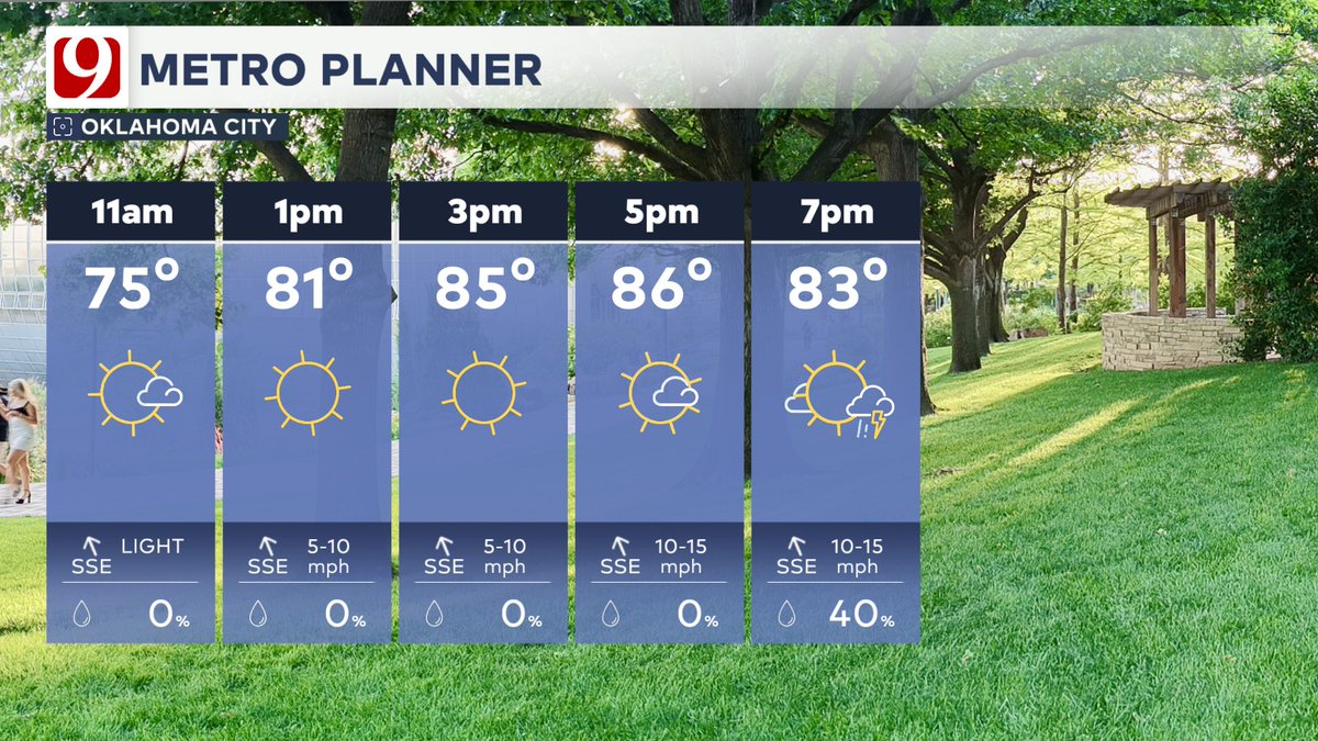
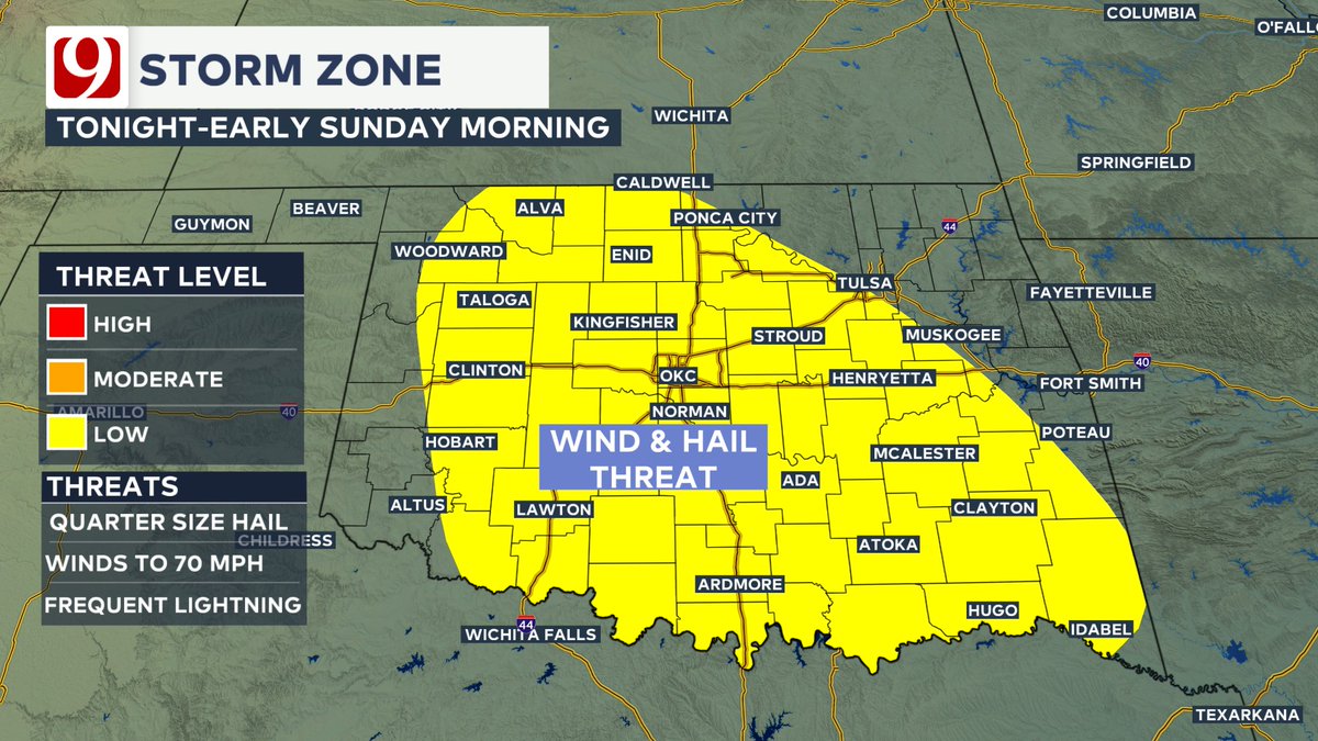
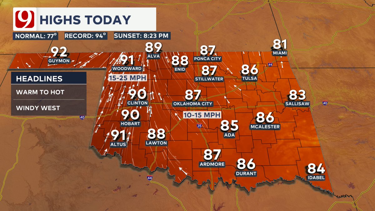
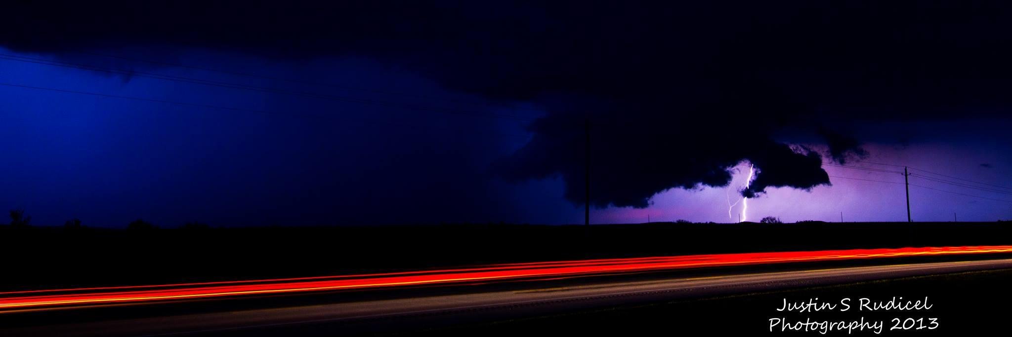
THE HEAT IS ON! STORM CHANCES RETURNING: Summer-like heat will build late week to near record highs. Some severe weather looks possible especially west during the late afternoons this week!
Justin Rudicel tweet mediaJustin Rudicel tweet mediaJustin Rudicel tweet mediaJustin Rudicel tweet media
English
0
0
1
108
Justin Rudicel
Justin Rudicel@ChasingtheMeso·
WE NEED MORE RAIN! We've had some rainfall during these first 10 days of May, but this is our wettest month of the year on average. We need a lot more! The next several days will be dry for central OK. Warmer highs will kick in & some 90s will be possible for C OK late week.
Justin Rudicel tweet mediaJustin Rudicel tweet mediaJustin Rudicel tweet mediaJustin Rudicel tweet media
English
0
0
0
136
Justin Rudicel retweetledi
Andrew Adams
Andrew Adams@AAdamsWX·
Let's warm things up this week, shall we? After a dreary and cool Mother's day, temperatures are on the rise and a drier stretch of weather takes hold. By Tuesday, western Oklahoma jumps back into the 90s. #okwx
Andrew Adams tweet mediaAndrew Adams tweet mediaAndrew Adams tweet mediaAndrew Adams tweet media
English
0
4
13
2.2K
Justin Rudicel retweetledi
Andrew Adams
Andrew Adams@AAdamsWX·
Lack of *consistent* upper air data has become frustrating. “Well they just send balloons up at 18z instead.” Okay? How does that help forecasts at 12z? Shouldn’t even be a question.
victor murphy@wxmanvic

How far has the US National Weather Service fallen? At 12z on 5/10, the Mexican Servicio Meteorologico Nacional has a far more robust Upper Air data set than the US. 10 states from AZ/NM to Canada have ZERO data. This w/an elevated risk of severe wx across much of TX.#txwx

English
0
5
13
2.2K
Justin Rudicel
Justin Rudicel@ChasingtheMeso·
HAPPY MOTHER'S DAY: Rain and storms will come to an end later today. With the wet ground, rain and clouds, highs will be cooler today. Chilly tonight and warmer and dry Monday!
Justin Rudicel tweet mediaJustin Rudicel tweet mediaJustin Rudicel tweet mediaJustin Rudicel tweet media
English
0
0
0
129
Justin Rudicel
Justin Rudicel@ChasingtheMeso·
2:09 AM SEVERE STORMS UPDATE & FORECAST: Severe storms continue S& W of OKC with hail to quarters or golf balls & gusts close ot 60 mph. More storms are forecast to develop within the yellow circled areas and only expand thru the AM. Severe weather and flooding will be possible.
Justin Rudicel tweet mediaJustin Rudicel tweet mediaJustin Rudicel tweet media
English
0
0
0
107
Justin Rudicel
Justin Rudicel@ChasingtheMeso·
1:23 AM SEVERE STORM UPDATE: A severe storm is SW of OKC NW of Chickasha and south of Cogar. Gusts to 60 mph and quarter sized hail possible. Frequent lightning is accompanying this storm. Moving ESE at 30 mph.
Justin Rudicel tweet mediaJustin Rudicel tweet media
English
0
0
0
88
Justin Rudicel retweetledi
Andrew Adams
Andrew Adams@AAdamsWX·
Radar Update 8:08 PM - Continuing to watch severe storms across western parts of the state. Storms from Sayre to Gotebo moving southeast. Should minimize metro impacts. Cold front storms in the NW also moving southeast. These move through metro later tonight. #okwx
English
0
6
21
4.1K
Justin Rudicel retweetledi
Andrew Adams
Andrew Adams@AAdamsWX·
Radar Update 7:27 PM - Cold front storms are now severe as they move southeast. Severe storms in western Oklahoma continue to moves east southeast. May bring rain to the south metro in the next hour or two. #okwx
English
0
6
26
5.7K
Justin Rudicel retweetledi
Andrew Adams
Andrew Adams@AAdamsWX·
Radar Snapshot 6:22 PM - Storms that have produced golf ball to tennis ball size hail continue to move east-southeast in western Oklahoma. #okwx
Andrew Adams tweet media
English
1
6
17
2.3K
Justin Rudicel retweetledi
Andrew Adams
Andrew Adams@AAdamsWX·
Severe Thunderstorm Warning for Beckham and Washita counties until 6:15 PM. Hail larger than quarters and 60 mph gusts possible. #okwwx
Andrew Adams tweet media
English
0
5
11
1.6K
Justin Rudicel retweetledi
Andrew Adams
Andrew Adams@AAdamsWX·
Radar Update 4:52 PM - Initial thunderstorms taking off in the eastern TX Panhandle and western OK. Not severe yet, but producing lightning. Watching for wind and hail risk as these storms grow. #okwx
English
0
5
20
3.2K
Justin Rudicel retweetledi
Andrew Adams
Andrew Adams@AAdamsWX·
Watching for shower and thunderstorm development in two areas this afternoon and evening. First is an area extending from the TX Panhandle into West OK, second is in the OK Panhandle/ SE KS. Strong to severe storms possible. #okwx
Andrew Adams tweet mediaAndrew Adams tweet mediaAndrew Adams tweet mediaAndrew Adams tweet media
English
0
6
13
2.2K
Justin Rudicel retweetledi
Andrew Adams
Andrew Adams@AAdamsWX·
Rain and storm chances expand overnight tonight. A few of these storms may produce some wind and hail. Unfortunately for the early-Mother's Day plans, rain chances linger for quite a while tomorrow. #okwx
Andrew Adams tweet mediaAndrew Adams tweet mediaAndrew Adams tweet mediaAndrew Adams tweet media
English
0
4
17
2.5K
Justin Rudicel retweetledi
Andrew Adams
Andrew Adams@AAdamsWX·
A Severe Thunderstorm Watch has been issued for the counties in blue until 10 PM. #okwx
Andrew Adams tweet media
English
0
5
16
1.7K
Justin Rudicel
Justin Rudicel@ChasingtheMeso·
SEVERE STORMS FOR MOTHER'S DAY WEEKEND: While most of Saturday looks great, storms will refire late afternoon across west OK. There will be a tornado, wind & hail threat as the storms develop & move east into the evening. More storms redevelop tonight.
Justin Rudicel tweet mediaJustin Rudicel tweet mediaJustin Rudicel tweet mediaJustin Rudicel tweet media
English
0
0
2
114
Justin Rudicel retweetledi
Andrew Adams
Andrew Adams@AAdamsWX·
Radar Update 7:14 PM - Cluster of severe storms has cleared the metro and continues south with a wind and large hail threat. #okwx
English
0
6
8
3.2K
Justin Rudicel retweetledi
Andrew Adams
Andrew Adams@AAdamsWX·
Severe Thunderstorm Warning for Caddo and Grady counties until 7 PM. Hail larger than baseballs and 60 mph gusts possible. #okwx
Andrew Adams tweet media
English
1
5
4
1.7K
Justin Rudicel retweetledi
Andrew Adams
Andrew Adams@AAdamsWX·
Severe Thunderstorm Warning for Lincoln county until 6:15 PM. Half dollar size hail and 60 mph gusts possible. #okwx
Andrew Adams tweet media
English
0
4
4
1.7K
Justin Rudicel retweetledi
Andrew Adams
Andrew Adams@AAdamsWX·
Radar Update 5:37 PM - Line of strong to severe storms continues to move southeast. Moving through the metro now. Damaging wind and hail possible in the most intense parts. #okwx
English
0
6
10
2.9K