
Okwir
5.6K posts
Okwir
@DOkwir
A Father I Humanitarian Worker I Counselor I Mental Health Enthusiasts I Child Protection Specialist & @LFC fan
🇺🇬 Katılım Haziran 2011
592 Takip Edilen1.8K Takipçiler


Arteta MUST GO!
Not tomorrow, not end of season but Today!
English

Very interesting indeed...what else don't we know?
Iran Embassy in Sweden@IRANinSWEDEN
You've probably heard the story of the Three Wise Men who traveled to Bethlehem to honor the newborn Jesus (PBUH), but did you know that they established a church in Iran upon their return? This is it: St. Mary Church in Urmia, Iran, built in the 1st century AD.
English

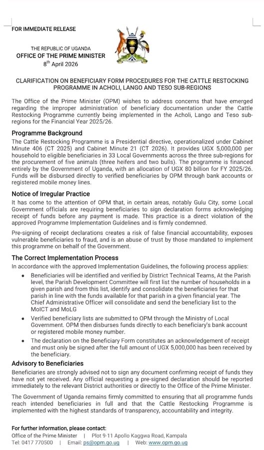
Information reaching my desk, says you are in the country, and you intend to attend the UOX Presidential debate moderated by @DaltonKaweesa. Come and we sort each other on why you keep making meemes out of my pictures.
Fahad Nyonjo King@kingFahad_17
Today’s office 📍City square || @KCCAUG
English
Okwir retweetledi

There are way too many mothers out there keeping their children from their fathers simply out of spite

English


English
Ladit @Comrade_Otoa, you were saying something or this is false too?
The Observer@observerug
Fuel prices in Arua city, northern Uganda now nearing Shs 7,000 mark as some major petrol stations; Vivo Energy, TotalEnergies, Shire, Oil Well...run out of supplies. This border district, Arua also supplies neighbouring Democratic Republic of Congo (DRC) and South Sudan. 📸 @judith_kukunda
English
@martinodong8 @Favourfm1 @MegafmGulu @RadioPacisGulu @CapitalFMUganda @RobinahNabbanja @norbertmao @OttoSam50178310 It's a big shame to the leadership of Gulu City.
English

This means Gulu City Authority have terribly error, Has Hon. Gilbert Olanya Effect Counted? @Favourfm1 @MegafmGulu @RadioPacisGulu
@CapitalFMUganda @RobinahNabbanja @norbertmao @OttoSam50178310
English
Okwir retweetledi
@DOkwir @cobbo3 Only if people buy into that narrative. A better solution is for people to learn about maps. When I was a kid we learnt about map projections at school - this debate would have been pointless. In fact, maps themselves had a little legend in the corner explaining how they worked.
English
@Pando_pop @cobbo3 Different style but same principle....you could say the US got a big ego😂! Either way, size is being used to frame power, which is exactly why how maps present size matters.
English
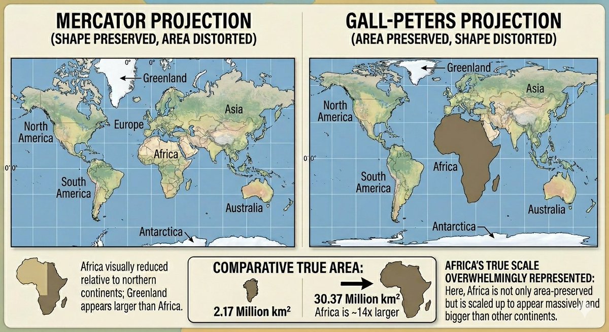
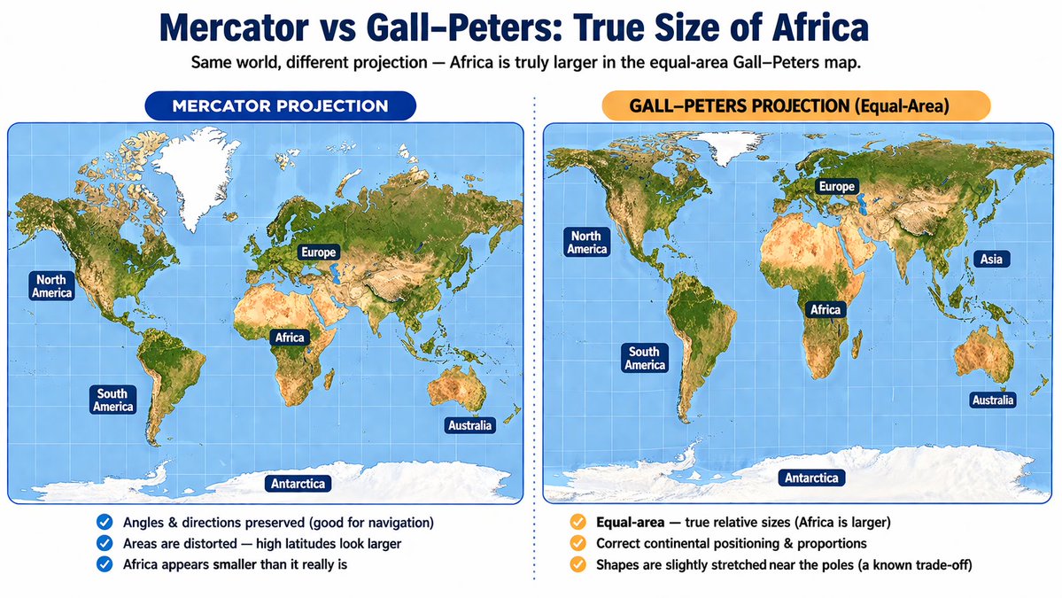
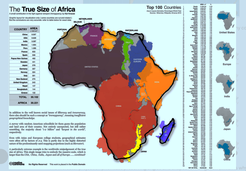
In 2026, the African Union resolved to tackle the historical size distortions of the 16th-century Mercator projection, which visuals diminish Africa. Togo is now actively campaigning for accurate maps, championing the Gall-Peters projection as a superior alternative that truly represents the continent's magnitude.
English
This is really interesting...it reminds me of how my late grandfather used to view picking a wife for marriage...size! A giant lady makes your kinsmen respect you (superiority) & that's the US mindset😂.
Pando@Pando_pop
@DOkwir @cobbo3 Today's imperialists - the US - have a very different attitude to size than the old European imperialists did, who were very proud of how small their countries were and how big their colonies were: they thought it proved their superiority. In the US mindset, big is better.
English
@Pando_pop @cobbo3 I totally agree, all projections distort! But not all distortions become the default worldview, the Mercator did & that’s the real conversation because in the end, this isn’t just about maps, it’s about mindset. I believe there's a strong reason why the UN chose to use Robinson.
English
Okwir retweetledi
@DOkwir @cobbo3 All map projections are distorted by definition. Personally, I prefer Mercator because the tropics look good, high latitudes aren't squashed beyond recognition and directions are true. But equal-area projections are sometimes useful too. The UN uses Robinson, not Mercator anyway.
English
Okwir retweetledi
@Pando_pop @cobbo3 I'm not denying that it is useful for navigation....the issue is that it is still widely treated as a default “world view,”
The question is, why a known distortion is still the dominant mental picture of the world in education & public consciousness.... isn't it deliberate?
English
Do we still need elections in this Republic?🤔
Parliament Watch@pwatchug
Electoral Commission budget slashed by 76% According to the report of the Committee on Legal and Parliamentary Affairs, the Electoral Commission’s budget has dropped from UGX 590.9 billion to UGX 140.8 billion. The report warns this sharp decline could affect core operations outside election periods. 📸 Courtesy: Parliament of Uganda
English

@DOkwir Not more than what i had the following working day. Man🙌
English
I once lied to my boss that I was sick, only to later discover that he was seated behind me at the meeting I had gone to attend. 😂😂😂🙌🙌
Miss Jidel 💖😘🇺🇬@Judie_Jidel
On my way to meet my man after lying to my boss that I’m sick 🤧 😹😹😹
English