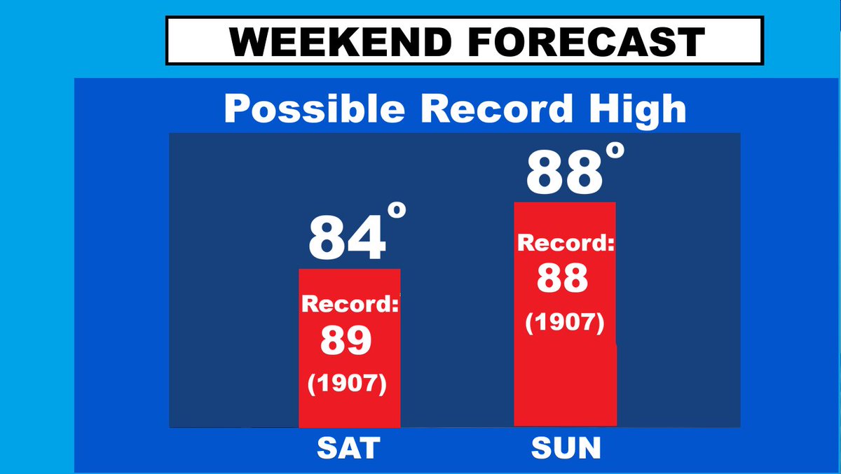
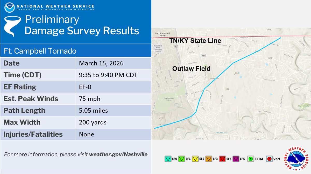
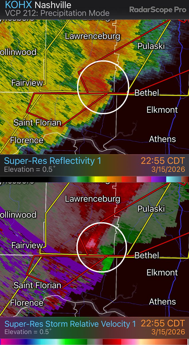
Davis Nolan
40.5K posts

Davis Nolan
@DavisNolan
AMS CCM, CBM, NWA. Retired WKRN Met, Florida State/Tulane grad, Jesuit H.S. '72. I believe in Jesus, but don’t think other religions are necessarily wrong.
WKRN Nashville Katılım Ocak 2011
347 Takip Edilen9.1K Takipçiler

@DanielleBreezy Prayers for Mike & his family and Debbie. God bless them. There was so much life and love ahead for them.
English

3 more tornadoes were confirmed in our KY coverage area. Logan County: EF-0, with peak winds 85 mph, Warren County: EF-1, with peak winds of 90 mph, & Clinton County: EF-1, with peak winds of 100 mph. That makes 6 in our area. Thanks to @DanielleBreezy for the TN/KY graphic.


English

How post storm storm surveys confirm & rate tornadoes: From my buddies @AlexLibbywx & podcast with @DanielleBreezy. See: wkrn.com/weather-headli…
English

A few sprinkles mixed with pockets of sleet or flurries later this morning, but nothing significant, then the big warm-up, before cooling down Monday. 7-Day thanks to @NWSNashville.

English

Here is the map of the CLARKSVILLE tornado that was determined to be an EF-0 with peak winds of 75 mph. See details: partnerservices.nws.noaa.gov/products/cache…

English

CLARKSVILLE: @NWSNashville survey teams have confirmed an EF-0 Tornado with peak winds of 75 mph between Clarksville & Ft. Campbell, plus straight-line wind damage in northern Montgomery County associated with the main line of storms. See details here: partnerservices.nws.noaa.gov/products/cache…

English


Alert: Special Weather Statement: Affects Orange, Washington, Scott +56 more. Expires at N/A. tinyurl.com/24yy2azf

English

REDBUD WINTER continues. Redbuds were blooming during last week’s cool down, and continue now. I checked Dogwoods, & saw some that were barely starting to show tiny blossoms. so I think it’s too early to call this Dogwood Winter. For those new to this, wkrn.com/weather-headli…
English

MT. PLEASANT-COLUMBIA/MAURY COUNTY: NWS Nashville survey teams have confirmed and EF-1 tornado with peak winds of 90 mph winds in the Mt. Pleasant and Columbia areas. See the full report here: partnerservices.nws.noaa.gov/products/cache…

English

LAWRENCE, GILES COUNTIES: NWS Nashville survey teams have confirmed an EF-1 TORNADO with peak winds of 105 mph in south Lawrence County-Giles Counties in the Bonnertown-Minor Hill areas. See full report here: partnerservices.nws.noaa.gov/products/cache…

English
Davis Nolan retweetledi

Davis Nolan retweetledi

1” OF SNOW REPORTED IN TULLAHOMA ❄️
As the heaviest band of snow continues to push east, an inch or so of new accumulation will be possible across Franklin, Coffee, and Grundy Counties.
Yes… we had tornado and severe thunderstorm warnings less than 12 hours ago.
Yes… I’ve been talking about this chance for snow.
Welcome to Tennessee weather!
Because ground temperatures are still relatively warm, most of this snow should melt fairly quickly once the heavier bursts move out.
That said, additional scattered snow showers and brief snow bursts will remain possible through sunset. ❄️
Photo from Keith Kinser

English

Alert: Winter Weather Advisory: Affects Clay, Pickett, Jackson +10 more. Expires at 03/16/2026 07:00 PM. tinyurl.com/27x6yp66

English


