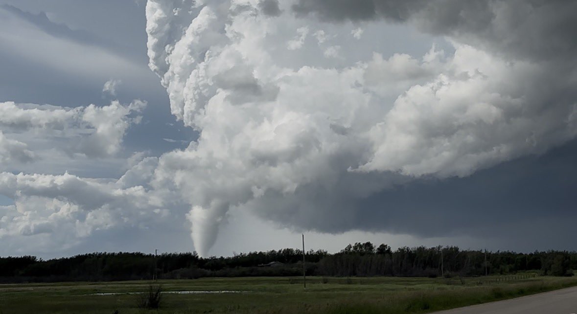
DeAndre Bevins

17.9K posts

DeAndre Bevins banner
DeAndre Bevins

DeAndre Bevins

@DeAndre_Weather

I like making analysis and graphics | Weather ENTHUSIAST | | Contact: [email protected] for questions or concerns | “MIDNIGHT SUN”

Katılım Ocak 2022
374 Takip Edilen1.4K Takipçiler
DeAndre Bevins retweetledi
Reed Timmer, PhD
Reed Timmer, PhD@ReedTimmerUSA·
Introducing THE MOST STATE-OF-THE-ART LIVE #TORNADO streaming setup ever deployed!! What we will attempt in 2026 with the Dominator 3 has never been done before. @willclay25 has designed a live streaming platform that has never been seen on this Planet. All you can do is stay tuned and buckle up! #Dominator #stormchasing
English
71
183
1.9K
77.1K
DeAndre Bevins retweetledi
Weather Track US
Weather Track US@weathertrackus·
While the weather is currently on the quieter side here in the CONUS, parts of the Middle East may experience a rare, high-end (even by our standards) severe weather setup on Thursday. A closed, compact and powerful upper trough will move across the region, with the exit region situated over parts is Saudi, Kuwait, Bahrain, Qatar and UAE. Seasonally deep moisture will be present, with high instability likely. Some capping may be present, which could limit storm development, but could be just weak enough to promote more isolated supercellular storms, capable of all severe hazards. If storms form, a significant severe weather/tornado event may ensue across parts of the region, mainly closer to the coastal regions.
Weather Track US tweet mediaWeather Track US tweet mediaWeather Track US tweet media
English
20
98
508
139.4K
DeAndre Bevins retweetledi
Weather Track US
Weather Track US@weathertrackus·
Scattered strong-severe storms ongoing in OH/PA this afternoon, with entirely just a wind/hail threat with this storms. Very high LCLs (cloud bases), promoted by loads of low-level mixing, and veered low-level shear greatly inhibits the tornado threat, and favors more strong downbursts and large hail. So far, no significant wind/hail reported yet, although if any instances of those events occur, they will likely be very isolated. Storm mode is a little messy, but there are a few more organized, isolated storms that may produce more significant hazards.
Weather Track US tweet mediaWeather Track US tweet media
English
0
6
27
3K
DeAndre Bevins retweetledi
Erik Creighton
Erik Creighton@ecreightonwx·
Perdyyy
Erik Creighton tweet mediaErik Creighton tweet media
Indonesia
0
3
48
1.8K
DeAndre Bevins retweetledi
Convective Chronicles
Convective Chronicles@ConvChronicles·
SPC has upgraded to Enhanced Risk (level 3/5) across eastern Ohio into southern/central Pennsylvania today. Confidence has increased in the coverage of intense supercells producing large to very large hail and damaging winds gusts (some perhaps hurricane-force) across this corridor this afternoon.
Convective Chronicles tweet media
English
1
12
62
4K
DeAndre Bevins retweetledi
James Pettus
James Pettus@PettusWX·
HRRR really said
GIF
GIF
English
5
3
72
5K
DeAndre Bevins retweetledi
Tim Grooms
Tim Grooms@tim_grooms·
This is one of those cases where too much clearing is a bad thing if you’re chasing severe weather. Surface heating is just going to steepen low-level lapse rates and aid in mixing more dry air to the surface. The problem is there is already too much dry air. This will zap instability and promote immediate outflow domination and junk storms. The reality check came hard and fast today.
Tim Grooms tweet media
English
8
7
84
20.1K
DeAndre Bevins retweetledi
JohnsonWx
JohnsonWx@225MPH_EF4·
ICYMI: My newest documentary covering the 2013 Moore EF5 is LIVE! I hope you enjoy! :) Link: youtu.be/7Wa3wQItlFc?si…
YouTube video
YouTube
English
0
8
30
2.2K
DeAndre Bevins
DeAndre Bevins@DeAndre_Weather·
There's a scattered threat for severe weather in the Ohio Valley and northern Mid-Atlantic. The environment is conducive for Large Hail and Damaging Winds with the small chance of a Tornado or two. So let's break down why this may occur. #SevereWx [Analysis Thread]
DeAndre Bevins tweet media
English
1
6
26
1.9K
DeAndre Bevins retweetledi
Sebastian Neidlinger
Sebastian Neidlinger@TwiistedTr33_·
SEVERE STORMS SUNDAY *Severe weather will not impact every town, in fact any town in specific is unlikely to experience severe weather A strong cold front will move through tomorrow evening, continuing our busy period of severe weather, and knocking temps from the 70s and 80s on Sunday to the 40s on Monday. With a nice EML (Elevated Mixed Layer) giving us very strong lapse rates, enough instability for thunderstorms, and a capping inversion that starts to erode in the evening as the front approaches, I see the potential for a few supercells with the risk for large hail, potentially up to 2" (hatched area) eventually congealing into a line with sporadic strong to damaging wind gusts. The extent of the hail threat will hinge on how long storms stay discrete. FAIL MODE: Clouds holding on longer in eastern PA (generally east of I81) shunting instability which would negate the severe threat in those areas. This is a real possibility, inversely, if clouds move out earlier the threat may increase further east. HATCHED AREA: 2" hail possible in isolated supercells that grow strong enough. ZONE 2: Isolated to widely scattered strong to severe thunderstorms capable of wind gusts up to 60-70MPH and half dollar sized hail. ZONE 1: A few isolated strong to severe storms with wind gusts up to 55-60MPH and quarter sized hail. Stay tuned for more updates tonight and early tomorrow. Have a great rest of your Saturday!
Sebastian Neidlinger tweet mediaSebastian Neidlinger tweet media
English
1
2
18
1.3K
DeAndre Bevins
DeAndre Bevins@DeAndre_Weather·
The threat for large hail will begin to fade, and damaging winds will likely persist in stronger thunderstorms.
English
1
0
3
84
DeAndre Bevins
DeAndre Bevins@DeAndre_Weather·
Once these strong-severe supercells initiate, they will likely persist west-southwest throughout the afternoon before gradually losing steam as night falls and surface temperatures begin to decrease in intensity.
English
1
0
1
87
DeAndre Bevins retweetledi
Max Velocity
Max Velocity@MaxVelocityWX·
HISTORY HAS BEEN MADE! The hottest temperature in the history of March for the United States has been set, at 112 degrees in Yuma, Arizona! This block-buster heatwave has shattered over 250 daily temperature records too!
Max Velocity tweet media
English
97
517
2.2K
75.4K