Ryan Dodd

4.5K posts

Ryan Dodd banner
Ryan Dodd

Ryan Dodd

@Dewmanchew69

Small business owner. Firefighter. Hockey and Baseball Allstar. Proud husband and father. It is a great day for hay.

Minto Katılım Ocak 2010
551 Takip Edilen280 Takipçiler
Ryan Dodd
Ryan Dodd@Dewmanchew69·
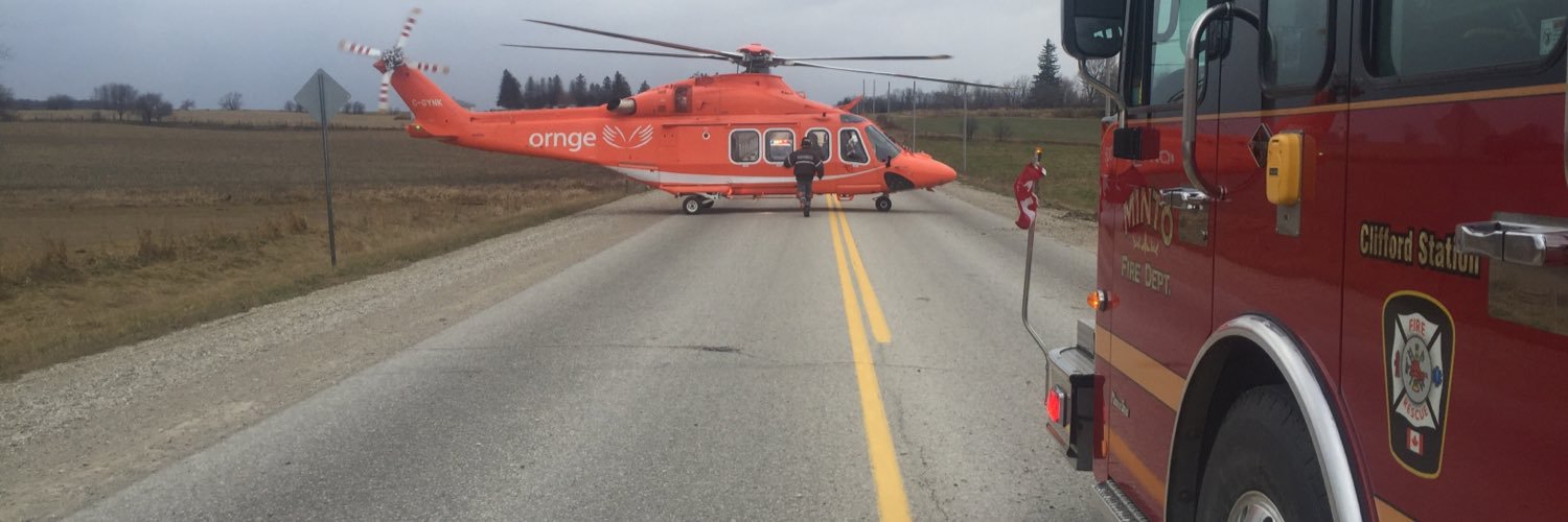
@WellyAdvertiser Use the area they use for the truck show in Clifford. Still Minto then
English
0
0
1
87
Ryan Dodd retweetledi
WxOntario
WxOntario@WxOntario1·
Significant Weather Outlook for Monday 👇 2-3cm of snow, locally across parts of SW #Ontario #OnWX #ONStorm
WxOntario tweet media
English
11
3
22
4.5K
Ryan Dodd retweetledi
Instant Weather Ontario ⚡️
#ONStorm #ONwx 🌸 Happy First Day of ‘Actual Spring’! 🌷 It’s been a long time coming for Southern Ontario, but the day is finally here! Today marks the start of a much more consistent stretch of spring-like weather across the region. Almost every single day this week will feature double digit daytime highs for most areas. Some parts of Southwestern Ontario and the Golden Horseshoe may even see multiple days climbing above 20°C, which is a welcome change after the back and forth we’ve been dealing with lately. We’re already off to a warm start this morning with widespread double digit temperatures, and Windsor has already hit 20°C. Temperatures will continue to climb through the rest of the morning. While there is some rain around early today, it will gradually clear out into the afternoon, setting the stage for a beautiful and mild spring day. Although it may remain cloudy in some areas. Of course, as the saying goes, ‘April showers bring May flowers’, and that looks to hold true this week. We’re expecting multiple rounds of rain and even a few chances for thunderstorms over the coming days. Over the next week, some areas could pick up between 50 and 100 mm of rain. This won’t fall all at once, but it will add up over time. That’s something to keep in mind, especially for areas already dealing with spring flooding, as this additional rainfall will continue to feed into already elevated rivers and watersheds. As for thunderstorms, we’re keeping a close eye on two separate rounds expected on Tuesday. The first round looks to arrive in the pre-dawn hours with storms moving in from the south and west. These will likely stay below severe limits due to the timing, but they could still be quite noisy and wake a few people up. Small hail is also a possibility in the stronger cells. A second, more impactful round may develop later in the afternoon and evening. The environment does appear supportive of stronger storms, but there is still some uncertainty. Some models suggest the morning storms could limit instability and delay redevelopment until after sunset, when the severe risk would be lower. We’ll be watching this closely and will have a more detailed forecast out later today or early tomorrow. Enjoy the warmth today, it finally feels like spring! - Brennen
Instant Weather Ontario ⚡️ tweet media
English
4
10
49
6K
Ryan Dodd retweetledi
Instant Weather Ontario ⚡️
#onstorm TUESDAY: We're working on a severe thunderstorm forecast for tomorrow (Tues, Mar 31st, 2026) across southwestern Ontario and perhaps into central, GTHA and Niagara regions. Multiple rounds of storms are possible, beginning with hail storms in the overnight and morning hours, which actually could bring marginally severe hail and intense lightning. The afternoon/evening storms are the main concern as they could bring damaging wind gusts, severe hail, frequent lightning, and isolated tornadoes. All hazards are certainly on the table with this system, especially in southwestern Ontario. We'll be streaming, for sure. More details ASAP! - Adam & the IW team
English
1
25
107
15.2K
Ryan Dodd retweetledi
WxOntario
WxOntario@WxOntario1·
Keeping a close eye on Thursday/ Friday for a large Winter Storm to impact Southern #Ontario All 3 major models ( 🇪🇺, 🇺🇸 and 🇨🇦) show a large swath of freezing rain across the region Uncertainty remains on the exact placement and duration of the event Deep SW Ont towards #Niagara look to remain all rain Will update daily #OnWX #ONStorm
WxOntario tweet mediaWxOntario tweet mediaWxOntario tweet media
English
15
22
116
23.1K
Ryan Dodd retweetledi
WxOntario
WxOntario@WxOntario1·
Strongest squalls this morning stretches from the #Underwood to #Harriston area Heavy snowfall rates are leading to reduced visibility and snow-covered roads Elsewhere, passing bursts of snow, heavy at times Snow should clear out by the afternoon #OnWX #ONStorm
WxOntario tweet mediaWxOntario tweet mediaWxOntario tweet media
English
1
7
20
2.5K
Ryan Dodd retweetledi
Moe Davis (U.S. Air Force, Retired)
Trump on Monday: “It looks small, but in person it’s very big. It’s the only plane capable of carrying a 200,000-pound bomb.” A B-2 has a maximum ordinance payload of 40,000 pounds. The heaviest bomb in America’s arsenal is the “Bunker Buster,” which weighs 30,000 pounds and is 20.5 feet long and 31.5 inches in diameter. So, to recap: America doesn’t have a 200,000 pound bomb and if it did the B-2 couldn’t carry it.
Moe Davis (U.S. Air Force, Retired) tweet media
English
825
2.6K
9.8K
316.3K
Ryan Dodd retweetledi
CP24
CP24@CP24·
Cardi B calls out Hamilton for low ticket sales: 'Not playing with y’all Banadians' cp24.com/news/entertain…
English
94
14
75
64.6K
Ryan Dodd retweetledi
WxOntario
WxOntario@WxOntario1·
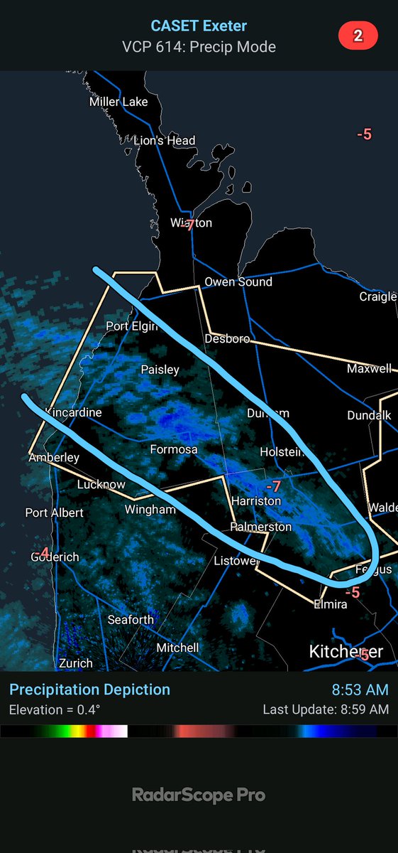
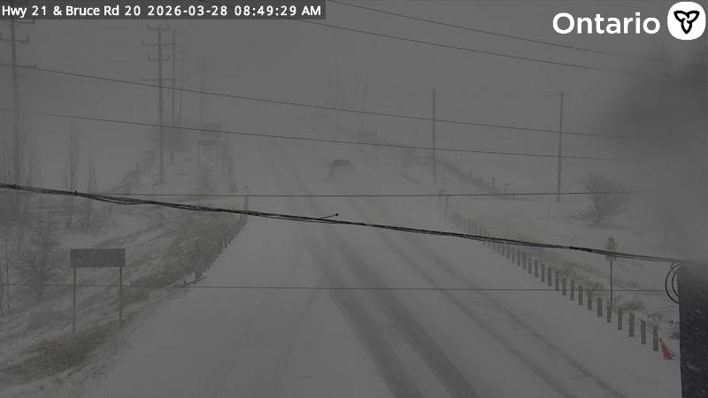
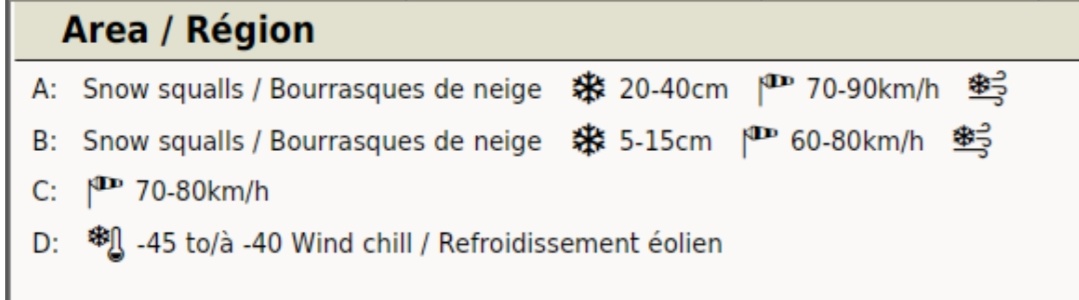
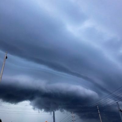
⚠️ Significant Travel Impacts Likely Monday PM to Tuesday across parts of the snowbelts ⚠️ As a strong cold front moves through Monday afternoon, temps will plumet Lake Effect Snow will develop along with 70-90+km/hr wind gusts and continue into Tuesday Major blowing/ drifting snow is expected across rural areas with road closures likely once again Will update... #OnWX #ONStorm
GIF
GIF
GIF
WxOntario@WxOntario1

Who wants to do what we did last night again? 😅 Latest Significant Weather Outlook shows a "High Risk" across parts of the snowbelts for Tuesday (Zone A) 10-25cm of snow, 70-90km/hr wind gusts and blowing snow possible The snowbelts continue to get hammered... #OnWX #ONStorm

English
2
6
35
25.6K
Ryan Dodd retweetledi
Stormwx1
Stormwx1@stormwx1·
This is a type of blizzard that may warrant a red level from Environment Canada. Absolutely ridiculous snowfall outputs on models with many showing a swath of 60-80+cm of snow with winds gusting over 80km/h for parts of WI, N MI, into central ON.
Stormwx1 tweet media
English
11
11
125
21.9K
Ryan Dodd retweetledi
WxOntario
WxOntario@WxOntario1·
Who's ready for more snow and wind 🙄 Another system slides through Southern #Ontario tomorrow AM bringing with it several hours of snow Wind gusts of 60-80+km/hr will once again lead to significant blowing/ drifting snow GOOD NEWS, temps warm up through the afternoon and by Monday AM, all this snow will be a distant memory with temps soaring to near 10C #OnWX #ONStorm
GIF
GIF
GIF
WxOntario@WxOntario1

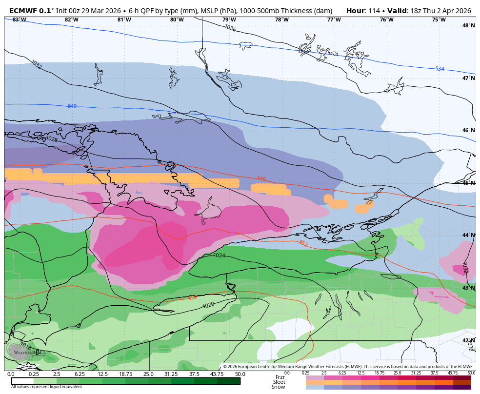
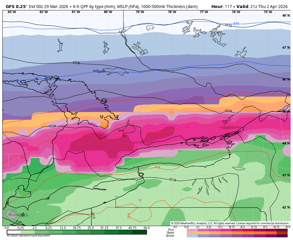
Keeping an eye on the 15th-17th time frame for a large storm to impact Southern #Ontario Looks like a windy/ messy mix Precip looks to start as a heavy thump of snow, change to rain then finish off as snow 50-80km/hr gusts most of the day on Monday Temps briefly warm towards the double digits Monday before a cold front plummets the temps well below freezing Will update tomorrow PM #OnWX #ONStorm

English
4
4
42
14K
Ryan Dodd retweetledi
WxOntario
WxOntario@WxOntario1·
Update on the Juicy Clipper for tomorrow 👇 If you've had enough of winter and don't want anymore snow, keep on scrolling Latest data is coming in further South and a lot more juicy Widespread 10-25+cm possible across most of the region (excluding Deep SW Ont) Wind gusts of 50-70+km/hr will lead to significant blowing/ drifting snow across rural areas of SW Ont School bus cancelations are likely Will update later today #OnWX #ONStorm
WxOntario tweet mediaWxOntario tweet mediaWxOntario tweet mediaWxOntario tweet media
WxOntario@WxOntario1

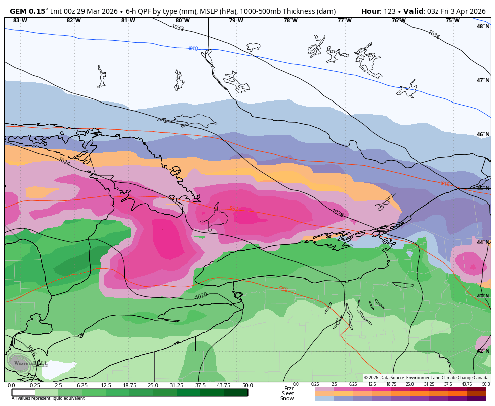
Update on our Juicy Clipper for Friday 👇 Uncertainty remains on the exact track Some models show bulk of the snow staying across the northern sections of SW #Ontario, others bring it south At this point, a general 4-8cm is possible for most, excluding Deep SW #Ontario Significant blowing/ drifting snow across rural areas with winds possibly gusting 50-70+km/hr Will have an update out tomorrow #OnWX #ONStorm

English
13
6
65
28.6K
Ryan Dodd retweetledi
Instant Weather Ontario ⚡️
#ONStorm #ONwx 🚨 Potentially Damaging Ice Storm Starting Tuesday Night into Wednesday We are becoming increasingly concerned about the potential for substantial freezing rain beginning late Tuesday and continuing into Wednesday for parts of Central and Eastern Ontario. While we are still a few days away and things could shift, the consistency among the models over the past several runs has been quite strong. Multiple models are continuing to point toward a corridor of freezing rain stretching from Parry Sound and Muskoka through the Haliburton and Bancroft area and into the Ottawa Valley. In some of these areas, the freezing rain could persist for more than 12 hours. This system will have plenty of moisture to work with, and some of the freezing rain could fall quite heavily at times, almost like a downpour of freezing rain. A particular area of concern right now is the Ottawa Valley, including Smiths Falls, Cornwall and Ottawa, where models are currently focusing the greatest icing potential. While model data often tends to overestimate freezing rain totals, some guidance is showing staggering overall precipitation amounts of 40 to 50 mm. Exactly how much of that will freeze and accumulate as ice will likely vary depending on surface temperatures. Even if only half of that amount ends up accreting as ice, it could still bring crippling impacts to parts of Eastern Ontario. This could include hazardous travel conditions, tree damage and potentially long lasting power outages. Widespread school bus cancellations appear increasingly likely, and in some areas even full school closures on Wednesday cannot be ruled out. We will have a more detailed preliminary forecast with our usual custom forecast maps posted later on Monday. For now, we wanted to provide an early heads up so those in parts of Central and Eastern Ontario can begin preparing for the potential of a significant ice storm. Those farther south are not completely out of the woods either. Freezing rain setups are notoriously finicky, and even a small shift in the temperature profile could push the freezing rain zone farther south or north. At this point, however, it appears more likely that Southwestern Ontario and the Golden Horseshoe will see mainly heavy rain, possibly transitioning to a bit of freezing rain or snow later on Wednesday as colder air moves in. Stay tuned! - Brennen
Instant Weather Ontario ⚡️ tweet media
English
7
28
110
17.6K
Ryan Dodd retweetledi
Instant Weather Ontario ⚡️
Instant Weather Ontario ⚡️@IWeatherON·
#ONStorm #ONwx Could parts of Southern Ontario see 20°C temperatures in early March? Let’s not get carried away… You may have noticed some viral posts on social media claiming exactly that, so we wanted to take a moment to address it and add some context. Yes, long range models are pointing toward a potential significant March melt developing next weekend and possibly continuing into the following week. Current indicators are showing temperature anomalies, which is the difference between the seasonal average and the estimated actual temperature, ranging from 10 to 20°C above normal. That sounds dramatic, and it is! If those anomalies were to verify, it would mean temperatures could run as much as 20°C above seasonal values. For this time of year, that would translate to highs pushing into the mid to upper teens and maybe even touching the low 20s in parts of Southern Ontario. However, there is a very important caveat… Long range models are not designed to provide precise forecasts that far into the future. They are useful for identifying general trends, such as whether we are heading into a colder or warmer pattern overall. Right now, they are suggesting a sustained period of milder than normal weather for early March across much of the region. What we cannot say with confidence is exactly how warm it will get or on which specific day it will happen. Model data becomes increasingly unreliable the further out you go. So when you see posts confidently claiming that Toronto will hit its first 20°C day of 2026 on a specific date that is still more than a week away, take that with a grain of salt. That level of detail simply is not something we can lock in this far out. That said, the overall signal for a thaw is there, and it is something to keep an eye on. It is especially notable considering that this upcoming weekend looks to feature potentially the coldest start to March we have experienced in several years. Some areas could be dealing with wind chills approaching -30°C on Sunday and Monday, which will feel like the dead of winter rather than the beginning of meteorological spring. We will be watching closely to see how this potential warm up evolves as we get closer to next weekend. If it does end up as warm as some of the current data is hinting at, rapid melting of our extensive snowpack combined with additional rainfall could raise concerns about localized flooding. There are still many moving parts, and plenty of time for the forecast to change. For now, it is fair to say a thaw is possible. A guaranteed 20°C day on a specific date is not. Stay tuned as we continue to refine the details in the days ahead. - Brennen
Instant Weather Ontario ⚡️ tweet media
English
5
19
74
12.4K
Ryan Dodd retweetledi
WxOntario
WxOntario@WxOntario1·
❄️🌬️Preliminary Snowfall Forecast for the Tuesday/ Wednesday Clipper - Quick hitting Alberta Clipper set to slide through Southern #Ontario Tuesday PM into Wednesday AM - Greatest impacts appear to be across Zone 3 where between the Clipper Snow and LES Wednesday AM, some areas could see 8-15+cm of snow. Strong wind gusts (40-60+km/hr) will lead to significant blowing/ drifting snow with whiteouts at times across rural areas - Still some uncertainty across Zone 1 (Deep SW Ont) as to how far SW the heavier snow reaches. At this point Trace to 5cm is possible - Elsewhere a general 5-10cm is likely with locally higher amounts possible - 30-50km/hr wind gusts most of Wednesday will lead to continued travel impacts throughout the day for all rural areas Timing: - Bulk of the snow will fall Tuesday Evening into early Wednesday AM - Impacts to the Tuesday PM commute not likely, Wednesday AM commute will be impacted Will continue to watch the latest trends/ data and have an update out tomorrow if needed #OnWX #ONStorm
WxOntario tweet media
English
2
9
62
22.9K
Ryan Dodd retweetledi
WxOntario
WxOntario@WxOntario1·
Update on the Thursday/ Friday storm *potential* Good news, storm has now trended south on all model guidance As of now, no impacts are expected Still 3 days out so it *may* track back towards the region Will continue to monitor and update #OnWX #ONStorm
WxOntario tweet mediaWxOntario tweet mediaWxOntario tweet media
WxOntario@WxOntario1

Great uncertainty remains with the Thursday/ Friday Storm *potential*! Last 4 runs of the 🇺🇸 model and 5 runs of the 🇪🇺 model 👇 The 🇺🇸 model has been consistent on significant impacts across Southern #Ontario The 🇪🇺 trended north them back south with no impacts Will continue to watch...and update #OnWX #ONStorm

English
5
1
48
16.1K