Dimetor

767 posts

Dimetor banner
Dimetor

Dimetor

@Dimetor_Connect

Turning telecom data into safety and business critical information in Aviation, Cyber Security and Defense.

Vienna Katılım Nisan 2020
863 Takip Edilen735 Takipçiler
Sabitlenmiş Tweet
Dimetor
Dimetor@Dimetor_Connect·
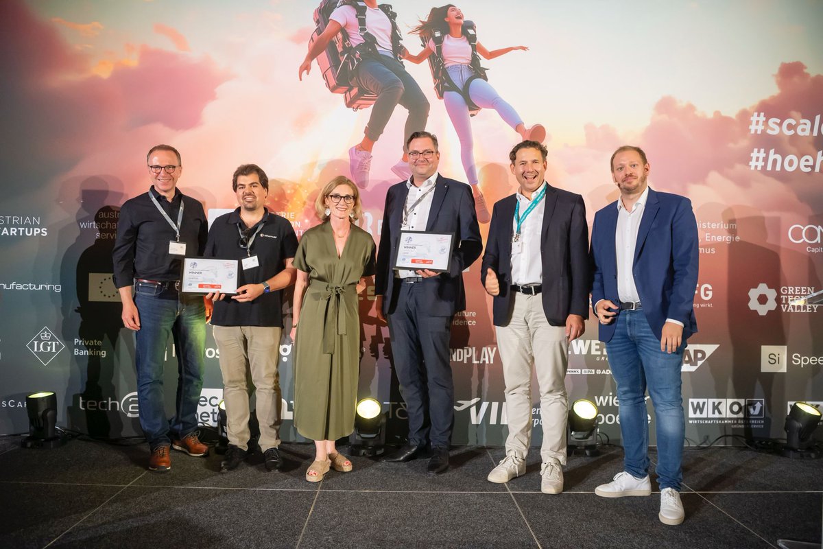
Last Wednesday, from over 250 submissions, Austria’s most successful scale-ups and the next rising stars were honoured. We are proud to have won the @EYnews award again in 2025 in the "SpaceTech & Aviation" category! 
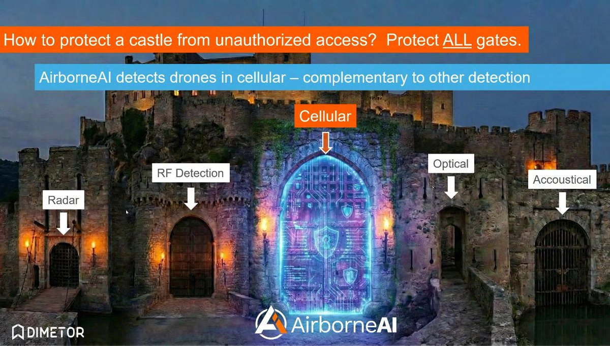
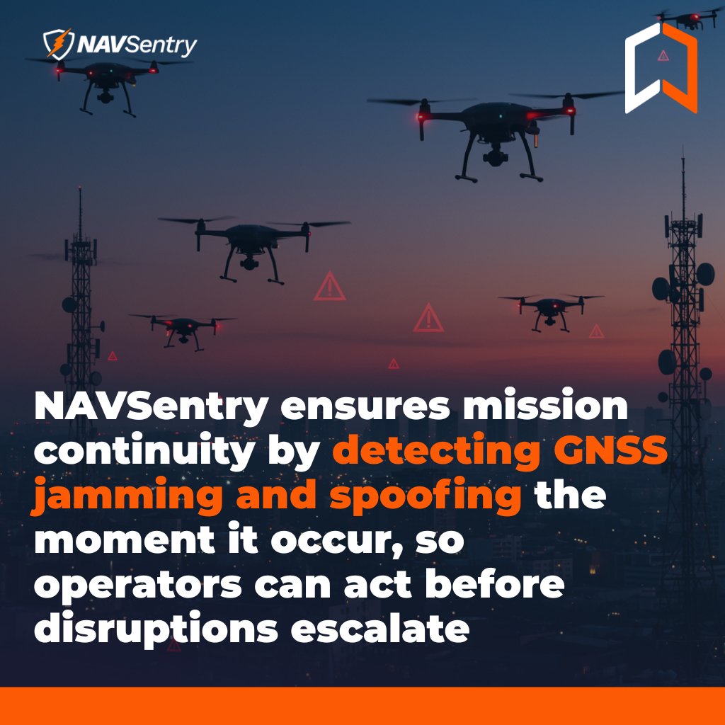
"To be recognised by the board of 70 judges from more than 250 start-ups is a great honour and a valuable recognition for the achievements of our entire team. The timing couldn't be better for us, as we just recently launched our new solution hashtag#NavSentry, focusing on advanced GNSS threat detection and prevention for securing critical operations," says @ThomasNeubauer_ _, our Co-Founder and CEO. More about the award here: lnkd.in/g8jffz_x
Dimetor tweet mediaDimetor tweet mediaDimetor tweet mediaDimetor tweet media
English
0
0
4
232
Dimetor
Dimetor@Dimetor_Connect·
Thomas Neubauer, Co-founder & CEO of #Dimetor, will speak at Xponential Europe this March in Düsseldorf on: “Securing Autonomous Operations: Dual-Use Lessons from Civil and #Military Domains” Civil and military #drone operations are increasingly using the same #airspace, networks, and navigation systems. This convergence introduces shared risks around #connectivity, #GNSS integrity, and operational resilience, particularly for #BVLOS drone operations and #autonomous missions. In this session, Thomas will speak about: - Practical lessons from civil and defense deployments - How #AirborneRF supports BVLOS drone operations with live cellular connectivity and population-density intelligence - How #NAVSentry detects and localizes #GNSS jamming and spoofing to protect PNT integrity - Why cloud-native, #AI-assisted platforms are becoming a requirement for scalable, compliant autonomous operations The talk focuses on operational realities, regulatory constraints, and dual-use system design, relevant to #aviation authorities, defense organizations, #telecom operators, and #UAS service providers. Attend on site to hear concrete implementation insights and deployment experience. More information about the event: xponential-europe.com
Dimetor tweet media
English
0
0
0
15
Dimetor
Dimetor@Dimetor_Connect·
Dimetor is exhibiting at XPONENTIAL Europe to demonstrate how #GNSS interference, such as jamming and spoofing can be detected and monitored by using #cellular networks as a massive, real‑time sensor system. By combining #telecom network infrastructure and Dimetor’s #NAVSentry technology, Dimetor is showcasing a breakthrough approach to safeguarding Positioning, Navigation and Timing (#PNT) services. Why this matters today? - Civil resilience: Modern #mobility, #logistics, emergency response, and critical infrastructure all depend on reliable GNSS signals. Interference, whether accidental or intentional, can disrupt transportation networks, delay supply chains, and compromise public safety. - #Defense readiness: Jamming and spoofing are increasingly used in hybrid and electronic warfare. Early detection and wide‑area situational awareness are essential to protect national security assets and ensure operational continuity. - Nationwide coverage: Traditional GNSS monitoring relies on isolated sensors. #MNO network scale enables continuous, country‑wide visibility, providing early warnings and actionable intelligence. - Trusted innovation: Dimetor’s interference‑intelligence technology creates a powerful, future‑proof capability for securing Europe’s digital and autonomous ecosystem. At XPONENTIAL Europe, #Dimetor will show how network‑powered sensing can protect both civilian life and national defense in an era where GNSS integrity has never been more critical. Visit us at XPONENTIAL Europe – @vodafone booth, Hall 1, Stand C35
Dimetor tweet media
English
0
0
0
30
Dimetor
Dimetor@Dimetor_Connect·
How do you protect airspace from unauthorized #drones? You protect all detection layers. Modern counter-drone systems rely on multiple sensing technologies: #radar, RF #sensors, optical systems, and acoustic detection. Each provides valuable information, but each also has limitations depending on environment, terrain, or #drone type. This is where cellular networks add a critical additional layer. With #AirborneAI, Dimetor enables rogue #drone detection through cellular #connectivity, complementing traditional sensor technologies and strengthening situational awareness across protected areas. By leveraging existing #telecom infrastructure as a large-scale sensing network, #AirborneAI can support: - Identification of airborne devices connected to cellular networks - Localization of non-cooperative drones - Friend-or-foe differentiation in complex environments - Integration into multi-sensor detection architectures The result: a more resilient and comprehensive #airspace protection strategy. Just like securing a castle requires protecting every gate, airspace security depends on combining multiple detection layers, including cellular intelligence. Learn more about AirborneAI: dimetor.com/solutions/
Dimetor tweet media
English
0
1
1
24
Dimetor
Dimetor@Dimetor_Connect·
Dimetor has been selected to present at the European Defence Fund (EDF) Info Days 2026 with the topic: “Detecting GNSS Jamming & Spoofing with Telco Networks as Sensor.” Organised by the European Commission’s DG DEFIS, the event brings together key stakeholders across EU defence innovation, R&D, and capability development. On March 11, in Brussels, Thomas Neubauer, CEO & co-founder of Dimetor, will demonstrate how #telecom networks can act as large-scale, real-time sensor infrastructure to support #GNSS integrity, airspace security, and #defence operations. As autonomous systems and connected assets scale, understanding #connectivity, positioning reliability, and interference in real time is becoming operationally critical. At EDF Info Days, Dimetor will showcase: #NAVSentry: detection and localisation of GNSS jamming and spoofing, enabling real-time PNT integrity monitoring #AirborneRF: connectivity intelligence from 4G/5G and satellite networks for C2 reliability, MCX validation, and ground-risk awareness #AirborneAI: detection and localisation of non-cooperative #drones using network-based data for security and defence use cases These capabilities transform #telecom infrastructure into actionable intelligence for defence, aviation, and critical infrastructure protection. If you are attending EDF Info Days, connect with us in Brussels to discuss collaboration and operational use cases.
Dimetor tweet media
English
0
0
0
16
Dimetor
Dimetor@Dimetor_Connect·
#Dimetor is on site this week at @MWCHub Barcelona (2–5 March, Fira Gran Via), connecting with #telecom, #aviation, and #defence stakeholders on how #connectivity becomes operational intelligence for #airspace. On the ground from our team: • @ThomasNeubauer_ – CEO & Co-founder • Gorazd Mirkovski – Project Director • Paul Dolejschi – Business Development You’ll find us at Hall 8.1 - 4YFN Stand 8.1C60, where we’re showcasing how: • #AirborneRF enables #BVLOS #drone operations with real-time 4G/5G and satellite connectivity insights • #NAVSentry detects GNSS jamming & spoofing to protect positioning integrity • #AirborneAI identifies non-cooperative drones and supports operational decision-making If you're at MWC and working on connectivity, UAS, or airspace operations, let’s talk. Meet us in Barcelona or schedule a meeting with the team.
Dimetor tweet media
English
0
0
0
38
Viasat
Viasat@viasat·
🛰️ New report with @vansonbourne: 91% of decision‑makers are adopting Direct‑to‑Device #IoT into their strategy. With standards‑based #D2D reducing cost & complexity, adoption is accelerating. Read more 👉 vsat.co/4rJKPeF
Viasat tweet media
English
1
3
6
346
Dimetor
Dimetor@Dimetor_Connect·
According to Drone Industry Insights, the #drone industry is entering a phase defined by operational deployment, measurable performance, and scalable execution. As missions expand into #BVLOS drone operations, urban environments, and #security-sensitive #airspace, the focus has shifted to #connectivity assurance, positioning integrity, and real-time situational awareness. Dimetor supports this transition by providing operational intelligence across #RF connectivity, #GNSS integrity, and airspace awareness, enabling informed decisions before disruptions impact missions. You can meet Dimetor at the following industry events in February and March this year: SPARTA – Europe’s Defence Innovation Summit | February 12, 2026 | Munich, Germany Mobile World Congress (@GSMA MWC 2026) | March 2–5, 2026 | Barcelona, Spain Hall / Stand: Hall 8.1 – 4YFN, Stand 8.1C60 @XPONENTIALshow Europe 2026 | March 24–26, 2026 | Düsseldorf, Germany Session: March 25, 15:30–16:00 (CCD South, Room 14) Thomas Neubauer will speak on dual-use lessons from civil and #military autonomous operations, covering connectivity assurance and GNSS protection. Across all three events, Dimetor will discuss how NAVSentry, AirborneRF, and AirborneAI support resilient, compliant, and scalable autonomous operations for civil, industrial, and defence environments. Meet us on-site or schedule a meeting in advance.
Dimetor tweet media
English
0
0
0
57
Dimetor
Dimetor@Dimetor_Connect·
Dimetor will join Europe’s No. 1 #Defense Innovation Summit, SPARTA | Deep Tech Momentum, taking place alongside the #Munich Security Conference 2026 in only one week! At SPARTA, Dimetor will present #NAVSentry and #AirborneAI, focusing on real-world capabilities for electronic warfare detection (#GNSS jamming & spoofing) and rogue #drone detection. Both solutions leverage #AI-driven analytics and transform existing large-scale infrastructure, including #telecommunications networks, energy grids, and other critical systems, into distributed sensor networks. This approach enables wide-area situational awareness, early threat detection, and actionable intelligence without relying on bespoke hardware deployments. As electronic warfare and uncrewed threats increasingly affect both civilian and defense domains, #data-driven resilience and cross-domain sensing are becoming key capabilities. SPARTA provides the right forum to discuss how these #technologies move from concept to operational reality. If you’re attending SPARTA, meet us to discuss real-world electronic warfare detection and rogue drone challenges. More information about the event: deeptech.build/sparta
Dimetor tweet media
English
0
0
0
33
Dimetor
Dimetor@Dimetor_Connect·
“Where in the airspace can drones fly safely and reliably?” This was the question at the latest @Techritory Forum on the Game of Drones panel, where Gorazd Mirkovski, Project Director at Dimetor, shared how the company is transforming #airspace #safety and operational intelligence. Gorazd highlighted four pillars of Dimetor’s approach: - Airspace connectivity awareness, enabling operators to avoid lost control incidents - Dynamic people density data, allowing real-time risk assessment over crowded areas - #GNSS jamming and spoofing monitoring, treating mobile #networks as a national “nervous system” for early alerts - Detection of rogue #drones through network signaling, preventing damage before it occurs These capabilities are applied through Dimetor’s #NAVSentry and #AirborneRF solutions, providing operators with real-time situational awareness, anomaly detection, and autonomous decision support. Learn more about how Dimetor turns #airspace #data into actionable insights here: dimetor.com/solutions
English
0
0
0
27
Dimetor
Dimetor@Dimetor_Connect·
"By 2030, the commercial drone market is expected to reach $80 billion, transforming industries from logistics to infrastructure inspection," according to TheDroneU, highlighting that the #drone industry is evolving rapidly, moving beyond simple flight to fully #connected, #autonomous, and secure missions. Key trends in 2026 include #BVLOS drone operations for long-range inspections, deliveries, and infrastructure monitoring; #AI-driven autonomy that supervises inspections, route planning, and data analysis; next-generation mapping with real-time 3D models; and advanced sensors and industrial payloads, from thermal and multispectral cameras to gas detection and edge processing, enabling higher-value insights across energy, #agriculture, and industry. At #Dimetor, we enable these trends with #AirborneRF, turning mobile network and airspace data into actionable insights for safe, scalable BVLOS drone and one-to-many operations; AirborneAI, supporting autonomous decision-making and AI-driven mission management; and #NAVSentry, providing real-time #GNSS and positioning assurance to protect missions from spoofing and jamming threats. Together, these platforms let operators harness AI, advanced sensors, and high-speed data safely and efficiently. Discover how Dimetor is already ahead of the 2026 drone trends and helping businesses scale safe, autonomous, and data-driven missions at: dimetor.com/solutions/
Dimetor tweet media
English
0
0
0
10
Dimetor
Dimetor@Dimetor_Connect·
GPS‑signal loss events increased by 220% between 2021 and 2024 according to data from the International Air Transport Association (@IATA) and the European Union Aviation Safety Agency (@EASA). When such interference occurs, maintaining reliable navigation, positioning, and timing becomes critical. Disruption can impact #drone operations, #aviation safety, and the resilience of critical infrastructure; potentially causing cascading effects across connected systems. #NAVSentry provides essential situational awareness in such cases. By integrating mobile network #data, GNSS sensor information and advanced analytics, NAVSentry can detect and classify jamming and spoofing activities with high temporal and geographical accuracy. When interference is detected, the platform automatically alerts operators and relevant stakeholders, enabling rapid, informed and coordinated responses. By continuously monitoring GNSS signals and integrating seamlessly into #airspace and network systems, NAVSentry strengthens operational resilience. This allows organisations to maintain continuity even under adverse conditions. Its advanced capabilities improve real-time detection, response, and recovery from GNSS threats, providing safety and reliability when it matters most. Find out more about how NAVSentry supports emergency response and critical operations on our website!
Dimetor tweet media
English
0
0
0
20
Dimetor
Dimetor@Dimetor_Connect·
One of the less discussed realities of the #drone economy is this: the world’s largest drone operators today are telecommunications companies. As our co-founder and CEO, Thomas Neubauer explains on @EYnews' Sky's Not the Limit podcast, drones are fundamentally mobile sensors. Whether they inspect #infrastructure, support emergency response, or enable #defense operations, their core task is always the same: collecting and transmitting #data. And moving data from a sensor to a control center is, at its core, a #telecommunications problem. That is why mobile network operators have quietly become central players in large-scale drone operations. Drones operate as airborne IoT devices, relying on continuous #connectivity to function safely and effectively in three-dimensional airspace. This becomes even more critical when distinguishing between attack and defense use cases. While offensive drones operate without the need for connectivity, defensive and civil missions depend entirely on reliable communications. Armed forces, public safety agencies, and infrastructure operators increasingly rely on drones as the first point of contact and that requires knowing, in real time, whether communication and navigation services are available and trustworthy. At Dimetor, this is exactly where our work sits. We use telecommunications networks as large-scale sensor systems, applying AI-driven analytics to assess connectivity availability and detect #GNSS disruptions such as jamming and spoofing. This live situational picture is essential for both civil airspace deconfliction and defense threat awareness. It’s what makes our solutions inherently dual-use: supporting safe civilian operations while strengthening situational awareness in defense environments. Listen to the full podcast to hear Thomas Neubauer discuss why telecom infrastructure has become a foundational layer of modern drone operations and what that means for scaling safely in a highly regulated world: youtube.com/watch?v=4yfNq1…
YouTube video
YouTube
Dimetor tweet media
English
0
0
0
32
Dimetor
Dimetor@Dimetor_Connect·
In fast-paced operational environments, managing multiple platforms can lead to delays and reduce situational awareness, potentially impacting mission success. #NAVSentry addresses these challenges by offering a modular data layer that integrates seamlessly with mission control, flight management, #UTM, #ATM, and command and control systems. This unified interface streamlines workflows and enhances coordination for civil and defense operators, enabling more efficient and effective mission execution. By embedding real-time interference data, threat forecasts, and actionable alerts directly into existing control systems, NAVSentry eliminates the need to switch between disconnected platforms. This integration accelerates decision-making and reduces complexity, ensuring that critical information is always available when it matters most. Situational awareness is the foundation of strong #GNSS protection, as you cannot defend what you cannot detect. NAVSentry’s mission-ready design supports continuous monitoring and intelligence gathering, enhancing operational reliability and security within evolving regulatory frameworks such as #SORA, U-Space, and #RemoteID. Solutions like NAVSentry are essential for advancing the safe, efficient, and sustainable operation of #drones and advanced air mobility in increasingly complex and congested airspace environments. Learn how NAVSentry enhances GNSS protection and streamlines integration with UTM and ATM systems: dimetor.com/5-reasons-why-…
Dimetor tweet media
English
0
0
0
39
Dimetor
Dimetor@Dimetor_Connect·
Europe’s #drone market is scaling fast, but scale only works with visibility and control. Recent industry data from Commercial UAV News shows Europe’s commercial #drone market already reached $7.3B, with drone services projected to hit $15.6B and create 145,000 jobs by 2030. #BVLOS operations, public safety use cases, energy inspections, and urban missions are moving from pilots to routine operations across the continent. What the report makes clear is that regulation is no longer the main blocker. @EASA’s Open, Specific, and Certified categories are defined. The real challenge now is operational: - knowing where drones can fly, - how safely they can stay connected, and - how risks change dynamically during a mission. This is exactly where Dimetor operates. Dimetor’s platforms bridge the gap between regulation and real-world execution by turning #telecom and #GNSS data into actionable intelligence for drone operators, #UTM providers, regulators, and critical infrastructure owners. Whether it’s enabling BVLOS #connectivity planning, real-time RF awareness, or GNSS interference detection, Dimetor provides the missing #data layer that allows drone operations to scale safely, sustainably, and compliantly. As drones become embedded into energy networks, public safety workflows, and future air mobility, airspace awareness, connectivity assurance, and interference monitoring are key infrastructure. The takeaway is simple: The drone economy isn’t limited by aircraft or regulation anymore. It’s limited by situational awareness. Read the full report here: commercialuavnews.com/reports/europe…
Dimetor tweet media
English
0
0
0
15
Dimetor
Dimetor@Dimetor_Connect·
As the year comes to a close, we want to thank our partners and customers for the trust, collaboration, and shared ambition throughout the year. From advancing #telecom-#aviation integration and #GNSS resilience to supporting real-world #BVLOS, mission-critical, and dual-use operations, 2025 has shown what’s possible when #technology, #regulation, and industry move forward together. We are grateful to work alongside forward-thinking organizations across #aviation, #telecommunications, public safety, and #defense, and we look forward to building the next chapter of digital #airspace together. Wishing you peaceful holidays and a successful New Year!
English
0
0
0
28
Dimetor
Dimetor@Dimetor_Connect·
Europe’s escalating drone threat shows one thing clearly: a physical “drone wall” is not a strategy for the 2025 reality. As recent incidents from Poland to Germany demonstrated, authorities can go blind within seconds, and no fence, jammer line or border installation can stop autonomous systems, swarms, or cyber-driven attacks. What Europe needs is the capability to detect what is in the air and understand who is behind it. That’s why the concept of a digital sky, highlighted in the FT and strongly supported by Global UTM Association (GUTMA), matters more than ever. Thomas Neubauer, CEO of Dimetor and member of the GUTMA Board, summed it up simply: “To detect rogue drones, we have to do two things: detect the drone, and determine whether it is a friend or a foe. At Dimetor ,we develop technologies for exactly that.” Digital aviation already provides the infrastructure Europe needs: – #Telecom networks and millions of mobile towers offering wide-area resilience – Real-time digital identification of cooperative traffic via #U-space – The ability to distinguish genuine #airspace users from those trying to hide – Shared situational awareness between civil and military actors This is the real foundation of modern air defence: not more hardware on borders, but a connected information layer spanning the entire territory. Dimetor is committed to supporting this shift. Our work at the intersection of telecom, #aviation, and defence contributes directly to the digital-sky vision Europe needs to protect its airspace in the era of ubiquitous #drones.
Dimetor tweet media
English
0
0
0
25
Dimetor
Dimetor@Dimetor_Connect·
The latest BBC analysis shows widespread reported #drone activity across #Europe in 2025, including incidents near commercial #airports, military bases, critical infrastructure, and multiple suspected incursions into Polish airspace. This rising frequency highlights a fundamental reality: Europe faces a distributed, fast-moving, and increasingly unpredictable drone threat landscape. And in such an environment, traditional perimeter-based defence models, like fences, walls, and hardware-only countermeasures, are no longer enough. What’s missing is the foundational layer called a “digital sky”: A shared, real-time operational picture of what is flying, where, and whether it is cooperative or rogue. At Dimetor, we contribute to this digital foundation: - #NAVSentry provides wide-area detection of #GNSS interference, often the first indicator of hostile activity. - #AirborneRF enables real-time assessment of #connectivity, airspace risk, and identification of cooperative drone traffic through telecom data. Combined, these systems help answer the two essential questions of modern #airspace security: Is there a drone? And is it a friend or foe? With #drone activity rising across Europe, strengthening this digital infrastructure is critical for aviation #safety, civil protection, and defence readiness. If Europe wants to protect its skies, it must first be able to see them. For the full article, visit BBC’s website: bbc.co.uk/news/articles/…
Dimetor tweet media
English
0
0
0
32