Sabitlenmiş Tweet
DrainALX
3.9K posts


DrainALX
@DrainALX
Advocating for, and educating ALX residents on major infrastructure issues that are being rapidly exacerbated by climate change. | RT ≠ Endorsements
Alexandria, VA Katılım Mart 2021
476 Takip Edilen1.2K Takipçiler
DrainALX retweetledi

Rain Rate Alert: Rain Rate at DelrayVA Weather, Alexandria - Alexandria, Virginia USA is 0.47 at March 16, 2026 at 09:18PM. Chance of Urban Flooding.
English
DrainALX retweetledi

DrainALX retweetledi

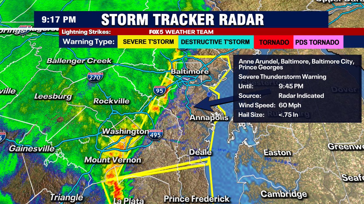
Add Baltimore city, Anne Arundel, and the rest of Prince George's County to the warning zone until 9:45pm.
DCA gusted to 54mph, Dulles to 66mph with this line.
English
DrainALX retweetledi
Temps are absolutely tumbling with this front.
60s in DC, lower 40s in Gaithersburg, 30s already along the I-81 corridor with mix being reported.
Another powerful March cold front!
English
DrainALX retweetledi

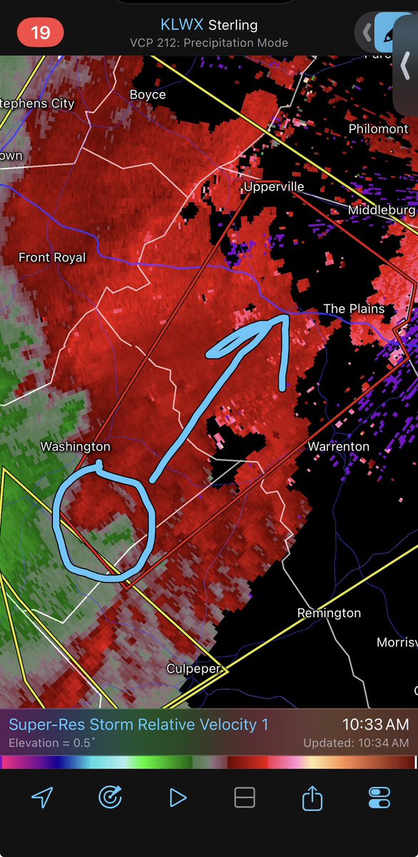
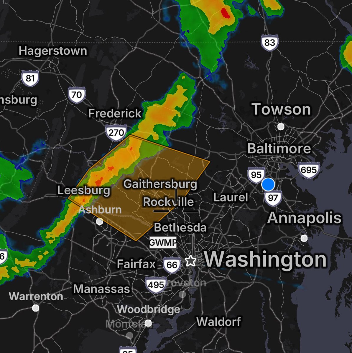
10:36AM: TORNADO WARNING for Rappahannock, Fauquier, and Culpeper counties until 11:00AM.
TAKE COVER NOW! Move to a basement or the most interior room on the lowest floor of a sturdy building. #vawx

English
DrainALX retweetledi

First tornado warning of the day... for eastern Rappahannock, northwest Culpeper and northwest Fauquier counties until 11 a.m. Radar indication.
* This dangerous storm will be near...
Hume around 1040 AM EDT.
The Plains and Delaplane around 1050 AM EDT.
NWS Tornado@NWStornado
Tornado Warning including Marshall VA and The Plains VA until 11:00 AM EDT
English
DrainALX retweetledi

JUST IN: ACPS to release students early due to severe storm outlook alxnow.com/2026/03/16/jus…
English
DrainALX retweetledi
🚨⛈️ SEVERE WEATHER OUTBREAK EXPECTED TODAY ACROSS THE DMV:
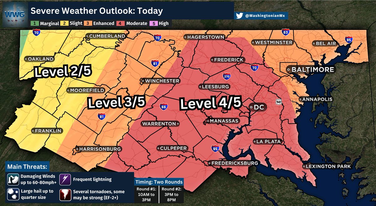
A potentially significant severe weather day is expected today with several rounds of showers and storms. The DC Meteo Area remains under a rare Level 4 out of 5 Risk for severe storms.
Two rounds of storms are expected, with the first occurring between 10AM-3PM as isolated showers, and storms develop ahead of the main line. These will be capable of producing isolated tornadoes, large hail, and damaging winds. Not everyone will see a storm.
Following the first round, a line of strong to severe storms is expected from west to east between 3PM-8PM. This line has the potential to produce widespread damaging to destructive winds, along with several tornadoes, some of which could be strong (EF-2+). This will be the worst of the weather for the DMV.
Widespread downed trees and power lines are possible today, along with several power outages. Roadways may be blocked and impassable due to debris.
Make sure devices are charged and that there are several ways to receive severe weather alerts. Use caution this afternoon and evening. #vawx #mdwx #dcwx #wvwx
English
DrainALX retweetledi

So far the trends are encouraging… junky morning cells left from the Carolinas are dirtying our “warm sector,” reducing how much storm fuel we’ll have for the afternoon round.
English
DrainALX retweetledi
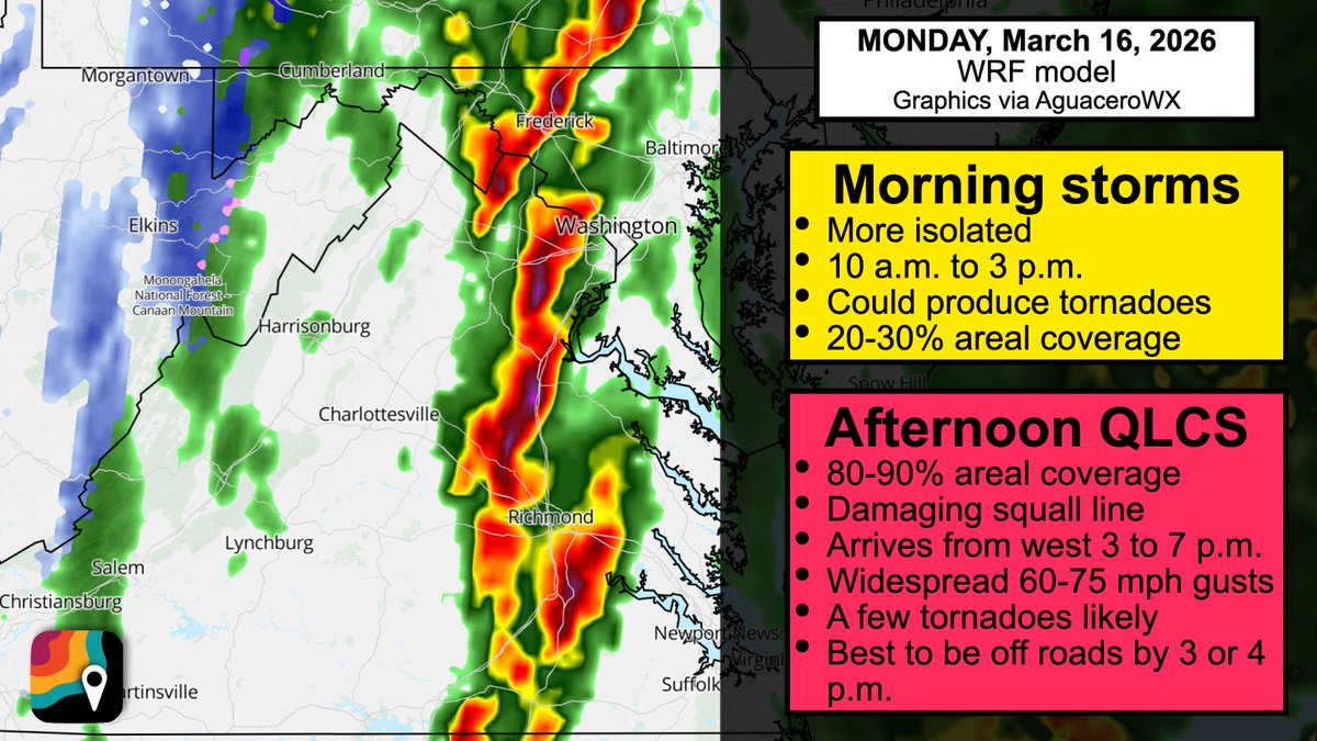
SUN PM update: D.C., Baltimore, Fredericksburg, Culpeper, Richmond, Virginia Beach, Norfolk, Charlottesville... be ready for multiple rounds of storms with possible tornado risk on MONDAY, March 16. PLEASE SHARE with friends/family!
The morning round will be more sporadic... 20-30% of folks might get an "appetizer" storm as the air mass becomes warmer and more humid. But changing winds with height will allow even the appetizers to rotate. That's why the risk for an isolated tornado or hail could start earlier.
The MAIN EVENT, a squall line with widespread damaging winds/embedded kinks of spin and a few tornadoes, comes through during the afternoon between 3 p.m. and 7 p.m.; we'll see widespread gusts of 60 to 75 mph and a few tornadoes, and there's even the chance of an isolated significant (EF2+) tornado.
We could see a bit of snow on the back side in the Blue Ridge, Potomac Highlands and I-68 corridor in the Maryland Panhandle during the evening as temperatures quickly drop behind the front.
English
DrainALX retweetledi

This is serious my friends and we all need to be Weather Alert on Monday! Good write up here by our friends at Capital Weather Gang!
Capital Weather Gang@capitalweather
* SERIOUS severe storm POTENTIAL on Monday * The National Weather Service Storm Prediction Center has placed the area in a level 3 out of 5 risk zone for severe storms on Monday, which is an unusually high level for our region this many days in advance. The exact timing of storms is still to be determined but any time between early afternoon and around sunset is possible. The storms should move through rather quickly but could pack a dangerous punch. An unusually intense cold front will be passing through and storms along and ahead of it could produce damaging wind gusts, hail and even tornadoes. As is often the case with potential thunderstorm events, exactly how widespread severe storms are and the places that will get hit hardest are difficult to pinpoint. There’s some possibility the storms don’t reach their potential if clouds and cool air linger on Monday, reducing available energy. The Weather Service is urging residents carefully monitor forecasts and be prepared for a significant outbreak of severe weather.
English
DrainALX retweetledi
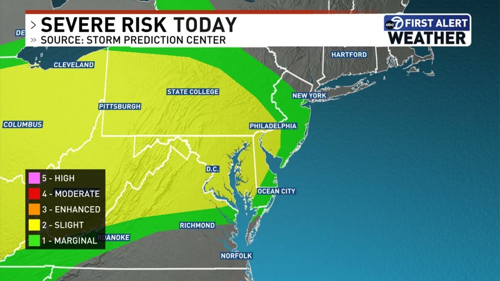
SERIOUS SEVERE WEATHER: The Storm Prediction Center has UPGRADED to a rare Level 4 out of 5 severe weather risk for Monday in the Mid-Atlantic. This includes Washington D.C., Richmond, Raleigh, Charlotte and part of South Carolina!
In the red zone, there is an increasing concern for a couple supercells that could produce an isolated EF2+ tornado, and given fast storm motions, we can't rule out a longer-track tornado as well.
This risk tier happens 3 times per decade on average in our area; the last times in D.C. were August 7, 2023 and April 19, 2019. These risk tiers are reserved for only the most substantial, higher-impact severe weather events that are somewhat reminiscent of what I chase out west.
Dangerous storms, some of which may produce 60-75 mph wind gusts, are likely. A few rotating supercells with tornado potential could crop up, and we'll also likely see a few brief spin-up tornadoes within the main squall line that should come through during the evening hours.
School districts – use Sunday to plan. Multiple rounds of potentially dangerous storms, including with some tornado risk, are likely in some spots.

English
DrainALX retweetledi
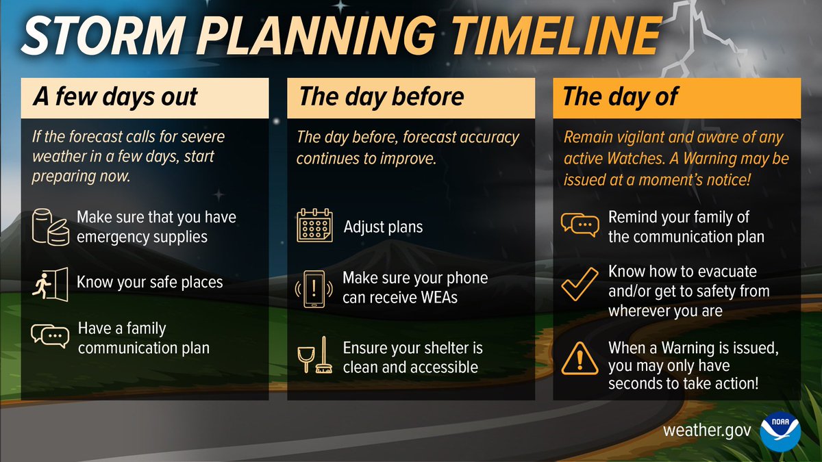
Folks, now is the time to start preparing for a potentially significant severe weather day on Monday.
Take the time to review your plans by identifying shelter locations like a basement or the most interior room on the lowest floor possible.
If you plan to be outdoors or away from home, make sure to know where the best shelter is and have a plan ready. When thunder roars, go indoors immediately!
Come Monday, stay alert to weather conditions and have multiple ways to receive alerts when they are issued. Adjust your plans as needed. #vawx #mdwx #dcwx #wvwx

English
DrainALX retweetledi

First @NWSSPC 'Slight' risk of the season for D.C.
I am confident it will be warm today, but not as confident with the storm coverage. Any storms that develop COULD reach severe limits. It's not a guarantee.
MORE: wjla.com/weather/first-…
English
DrainALX retweetledi

A large portion of the eastern US from East Texas to Pennsylvania and the Delmarva is under a level 2 out of 5 threat for severe weather today. Large hail, damaging wind gusts, and tornadoes are all possible.

English
DrainALX retweetledi
7:43AM: Some much heavier bands of rain are moving eastward towards the I-95 Corridor in NOVA and even the Capital Beltway should get in on this too. Some rumbles of thunder will be possible.
This will likely roughen up the morning commute in these areas. Make sure to use your headlights, wipers, keep distance from other vehicles, and give yourself extra time to travel. #vawx #mdwx #dcwx
English
Hello, D.C. gang. I am home.
I brought you all a round of storms as a gift. Expect some hefty boomers in the next 90 minutes.
Love,
Matthew 💙
English
DrainALX retweetledi
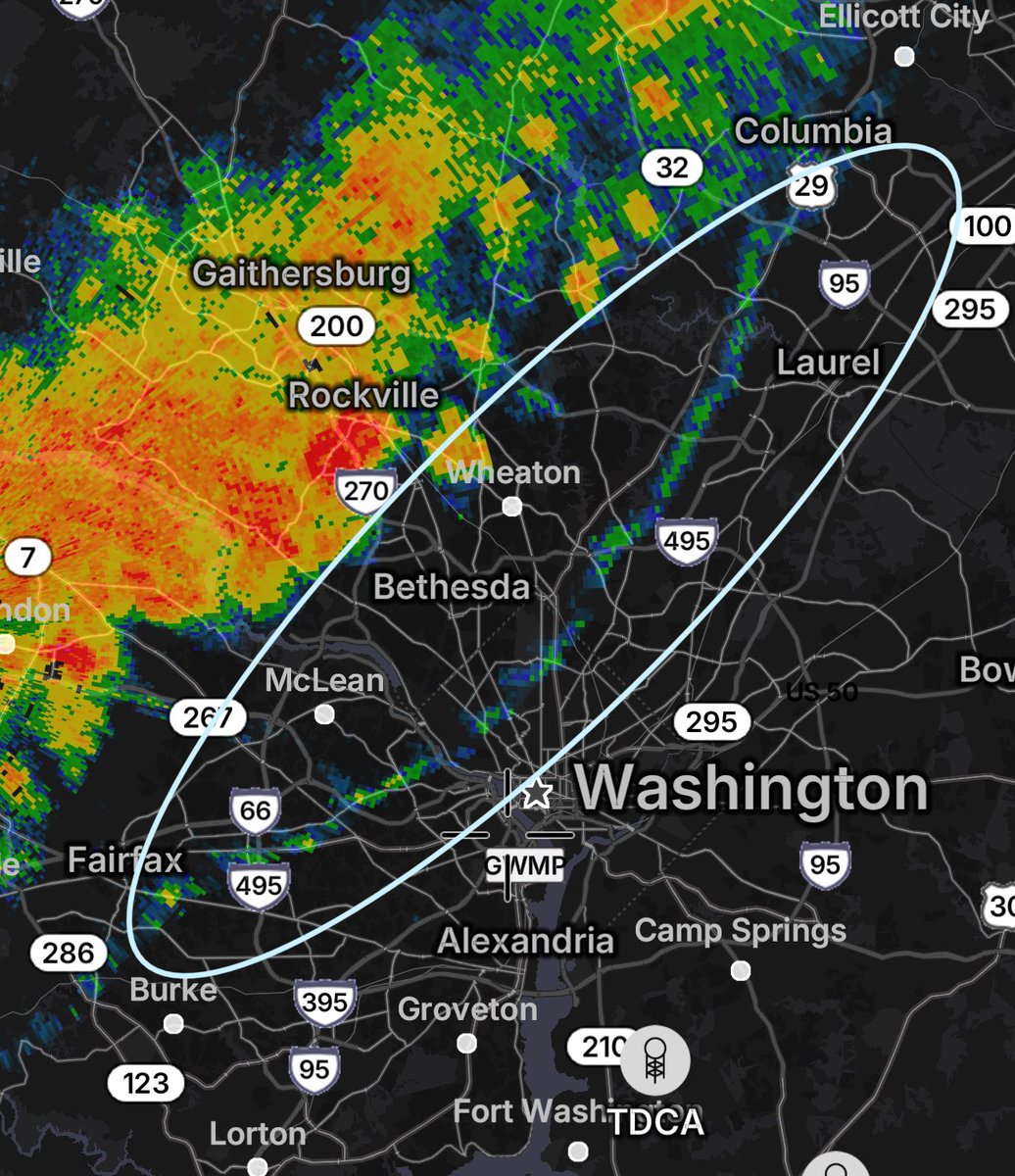
DMV gang — y’all see that blue line on the radar? That’s the “outflow boundary,” or leading edge of cool air exhaust and gusty winds from storms.
Expect a cool breeze, sudden 40+ mph gusts and perhaps a really pretty shelf cloud.
Send me your “shelfies”!
English
DrainALX retweetledi