
Elle S
1.3K posts
Well look who’s shaking hands today. Elan has always been one of us, way before he could drive. He’s the real deal. He’s a good man. Today, he graduates with a meteorology degree, and we could not be more proud. Congratulations E!

English
@NashSevereWx Is the thinking of the atmosphere isn’t going to able to support anything severe?
English
Why yes we can! Current thinking... The first showers possible from mid-morning into early afternoon, then showers and thunderstorms more likely later in the day and into Sunday night.
Homegrown Libertarian@HGLibertarian
@NashSevereWx Can we get an update for Mother’s Day, please?
English
@NashSevereWx @bookiffin What kind of storms are going to be here for Sunday?
English
@bookiffin Takes time to crunch the numbers and collect the data.
English
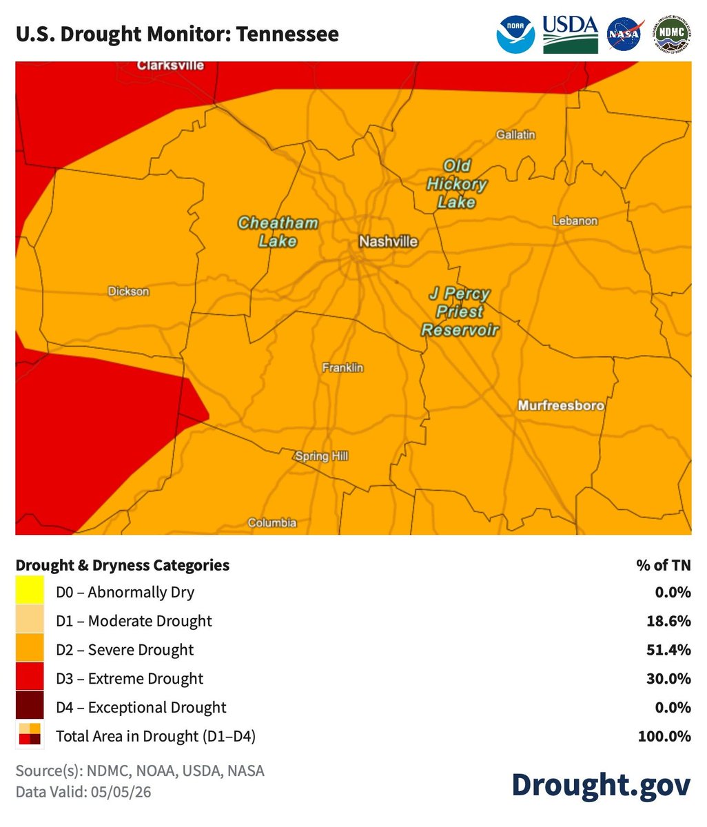
New drought map shows slight improvement for some. Severe drought remains. Better than extreme tho. Yesterday's rain was not included in this map. That will be reflected in next week's map.
English
@NashSevereWx @officiallyDRG We can go to bed., this isn’t a storm we need to stay up for until it’s over right? If we have an alarm to wake us up If need be?
English
@officiallyDRG Showers and thunderstorms possible overnight. Some storms may be severe with strong winds the biggest threat.
English
Very Low-End Chance for Severe Storms Tonight, Additional Showers/Storms Wednesday PM.
New blog here nashvillesevereweather.com/2026/05/05/ver…
English
@NashSevereWx We are under a marginal level one threat, do you still think the severe weather is minimal?
English
@NashSevereWx Any storms on the horizon? Some weather ppl are saying May 5 we could be getting a bad storm? Or just fear mongering?
English
Quiet and Cooler Weather.
New blog here nashvillesevereweather.com/2026/04/29/qui…
English
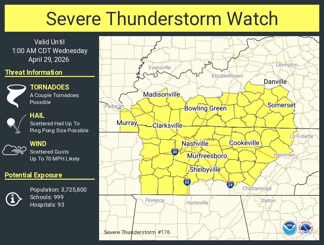
The severe thunderstorm watch, originally scheduled to expire at 1:00 am has been canceled 5 hours early.
GIF
English
Some details on the severe thunderstorm watch just issued. Expires at 1:00 am. A couple of tornadoes not out of the question somewhere in this huge area highlighted in yellow. Scattered hail up to ping-pong ball size possible as well as some scattered gusts to 70 mph.
English
Alert: Mesoscale Discussion: Affects western and Middle Tennessee into southern Kentucky. Expires at 04/28/2026 11:45 PM. greenewx.com/maps/maps/nwws… severe weather.html

English
@NashSevereWx Some other news outlets are saying two round of storms? Are you seeing any of this?
English
Severe weather possible again tonight. Here's today's blog breakdown. youtube.com/watch?v=1k_wvu…
YouTube
English
@NashSevereWx Is anixety lower for this storm than last night? I’m just worried about tornadoes
English
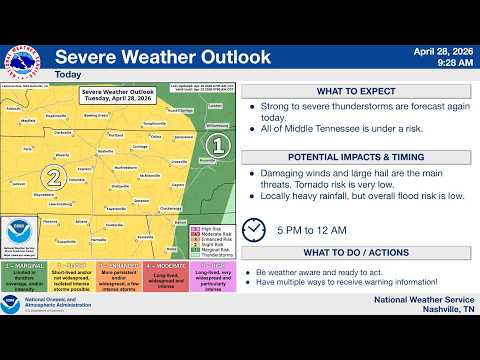
Additional Severe Weather Possible This Afternoon/Evening.
Latest details here in the new blog nashvillesevereweather.com/2026/04/28/add…
English
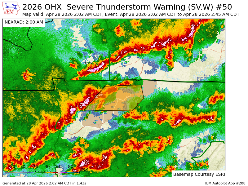
OHX issues Severe Thunderstorm Warning [wind: 60 MPH (RADAR INDICATED), hail: 1.00 IN (RADAR INDICATED)] for Cheatham, Davidson, Dickson, Montgomery, Robertson, Sumner [TN] till 2:45 AM CDT mesonet.agron.iastate.edu/vtec/f/2026-O-…
English
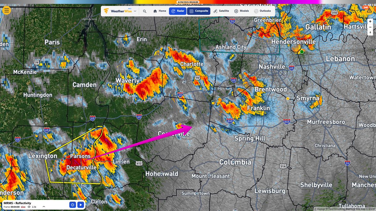
Strongest storm of the night *so far* is this one about to cross the TN River. It'll be headed our way if it holds together. The atmosphere is evolving quickly into the storm producing type we expect this time of year. So, expect more storms as we go through the night, not less. 12:08 am
English
@deadlife0002 @NashSevereWx @JuliaGilinets I was ready to stay up all night if need be tho. Who needs me to be functional tomorrow at work
English

SPC will be expanding the tornado watch to the I-65 corridor shortly. Again, this is a WATCH, not a warning....meaning conditions are favorable for the formation of tornadoes.
English
@AnnaHutchisonn @NashSevereWx Oh okay, I guess I didn’t see that. Thank you
English

@ElleElizabeths @NashSevereWx They just answered this under another post! They said the threat is still low
English
If this one holds together, it's going to be a noisy one for Williamson and S Davidson. Probably a hailer and lots of lightning. Pay attention starting now.

English
Our weather balloon getting a great snapshot of the atmosphere above Davidson County. Traveling at over 11k ft now, it shows the cap is basically gone, which makes sense based on radar.

English
@NashSevereWx @RaNdOmAcT31 Is that bad that it isn’t scattered storms and more of a line?
English
@RaNdOmAcT31 Could go either way, but I'm leaning toward a solid line now
English
10:08 pm, Non-severe brief downpours have bubbled up right on schedule in NW Middle TN. These will move NE. We're going to see if we can get a weather balloon up out ahead of them and see the status of the cap up around 10,000 ft. Your donation money put to good use! Thank you!

English