Roberto Granda

8K posts

Roberto Granda banner
Roberto Granda

Roberto Granda

@EnMet3

Divulgación, previsiones y análisis de situaciones meteorológicas en España. Meteorólogo en @eltiempoes. Geógrafo. @Robertohorche

Katılım Aralık 2018
322 Takip Edilen8K Takipçiler
Sabitlenmiş Tweet
Roberto Granda
Roberto Granda@EnMet3·
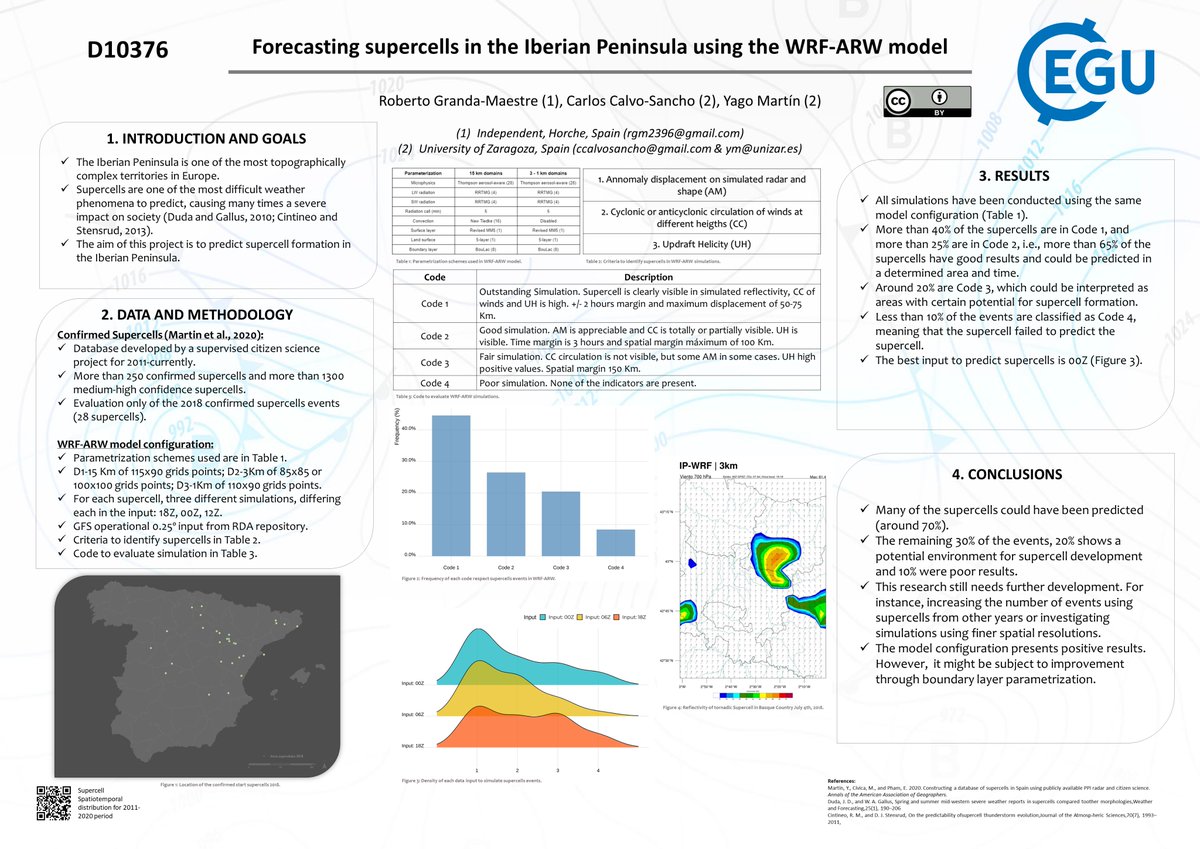
Hoy he presentado el trabajo sobre predicción de supercélulas que he realizado con @MeteoZGZ y @Supercelulas Es un póster, resumido, pero en este pequeño hilo voy a explicarlo algo más. ¿Quieres saber qué resultados hemos obtenido? ¡Sigue leyendo! 👇
Roberto Granda tweet media
Español
7
36
114
0
Roberto Granda
Roberto Granda@EnMet3·
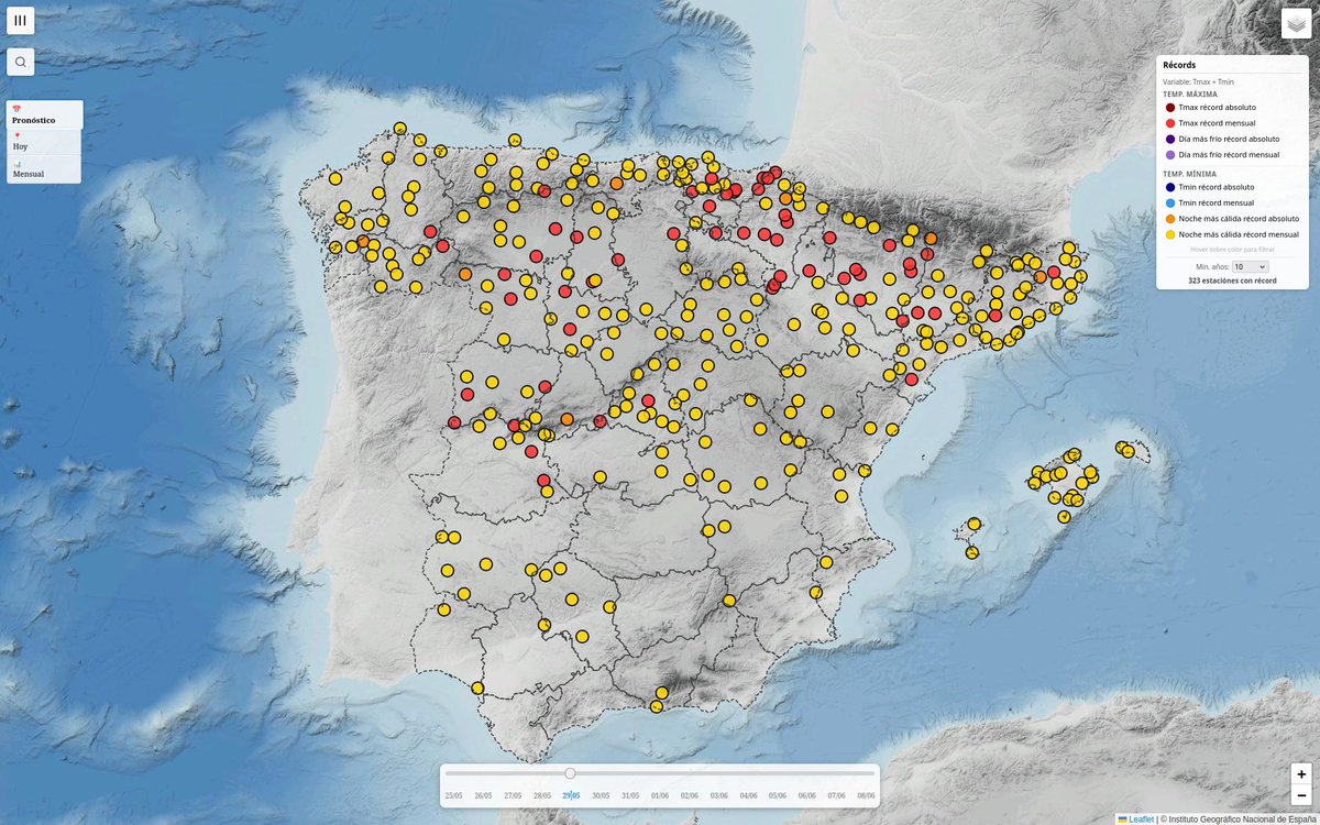
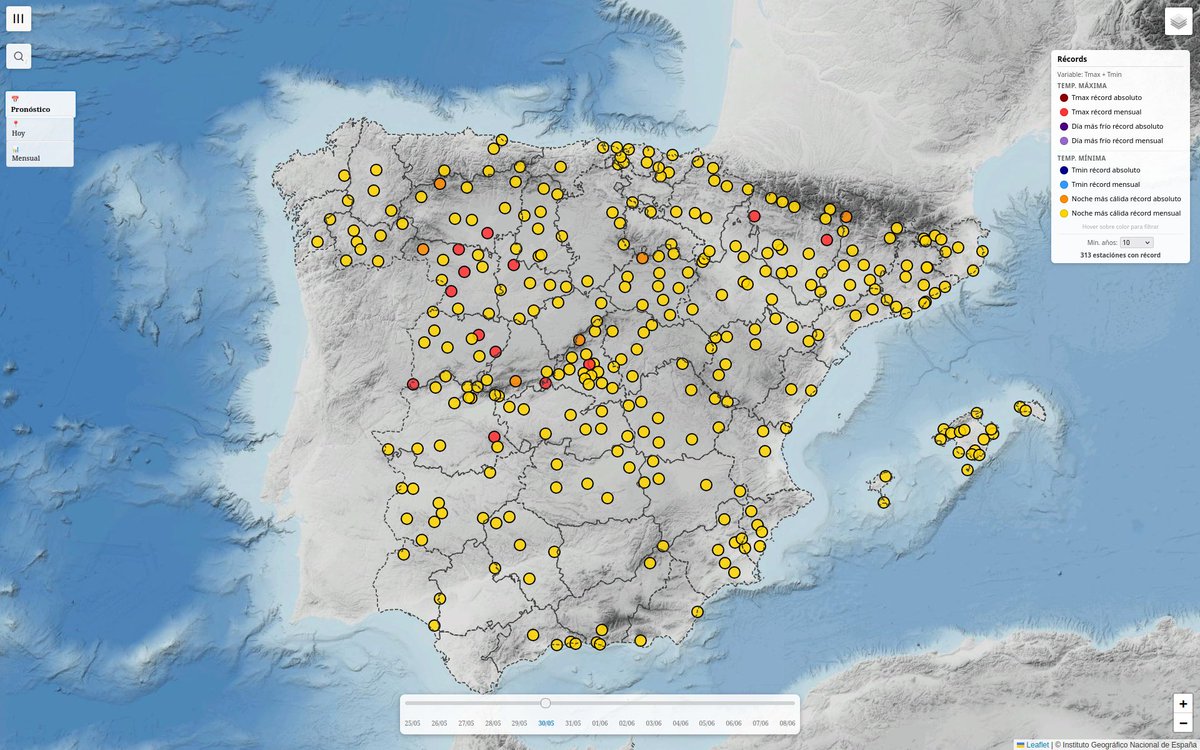
Y estos son los posibles récords, según previsiones, que podrían caer tanto el viernes 29 como el sábado 30. Pero eh, es el calor de toda la vida...
Roberto Granda tweet mediaRoberto Granda tweet media
Español
0
5
11
708
Roberto Granda
Roberto Granda@EnMet3·
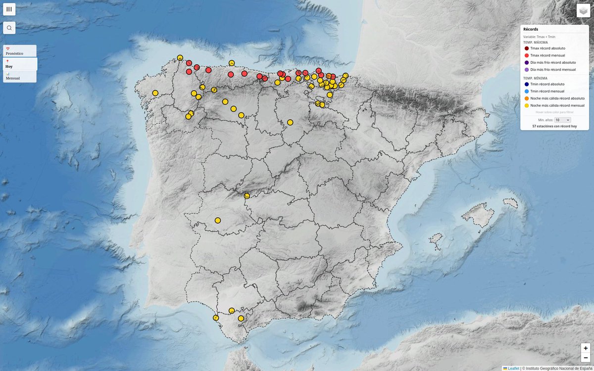
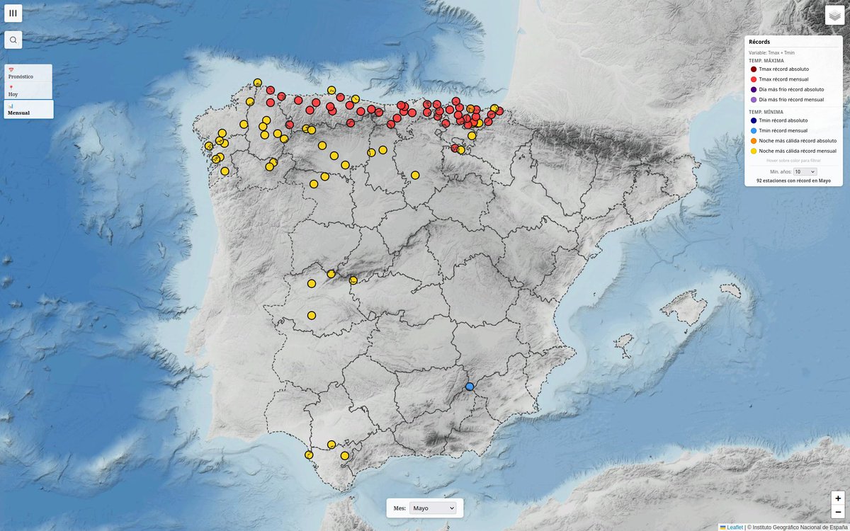
Hoy, lunes 25 de mayo, vuelven a caer récords. Oviedo bate por 3º día su antiguo récord de mayo, y también ha registrado su primera noche tropical en cualquier mayo El segundo mapa muestra todos los récords acumulados este mayo. Aún dirán que hubo muchos récords fríos...
Roberto Granda tweet mediaRoberto Granda tweet media
Español
7
5
21
1.2K
Roberto Granda
Roberto Granda@EnMet3·
Durante los próximos días, estaremos inmersos en la dorsal. No obstante, una serie de ondas cortas podría recorrer el norte del país, introduciendo cierta inestabilidad que daría lugar a tormentas y chubascos
Roberto Granda tweet mediaRoberto Granda tweet media
Español
0
2
16
1K
Roberto Granda
Roberto Granda@EnMet3·
Zamora podría registrar desde el miércoles varios días (3-4) más sobre 34 ºC. Este 2026 ya lleva uno. ¿Sabéis cuántos ha tenido desde 1931 (primer año con datos de temperatura)? 8 ¿Cuántos previos al 2000? 1 ¿Cuántos desde 2020? 4 Pero es el calor de siempre, sin duda
Roberto Granda tweet media
Español
9
25
55
2.4K
Roberto Granda
Roberto Granda@EnMet3·
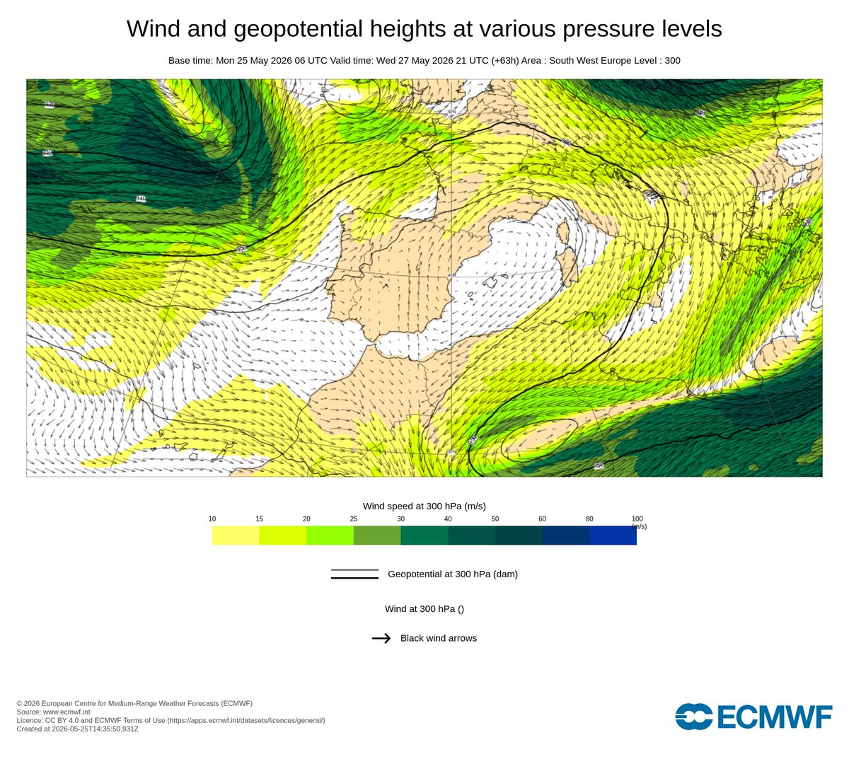
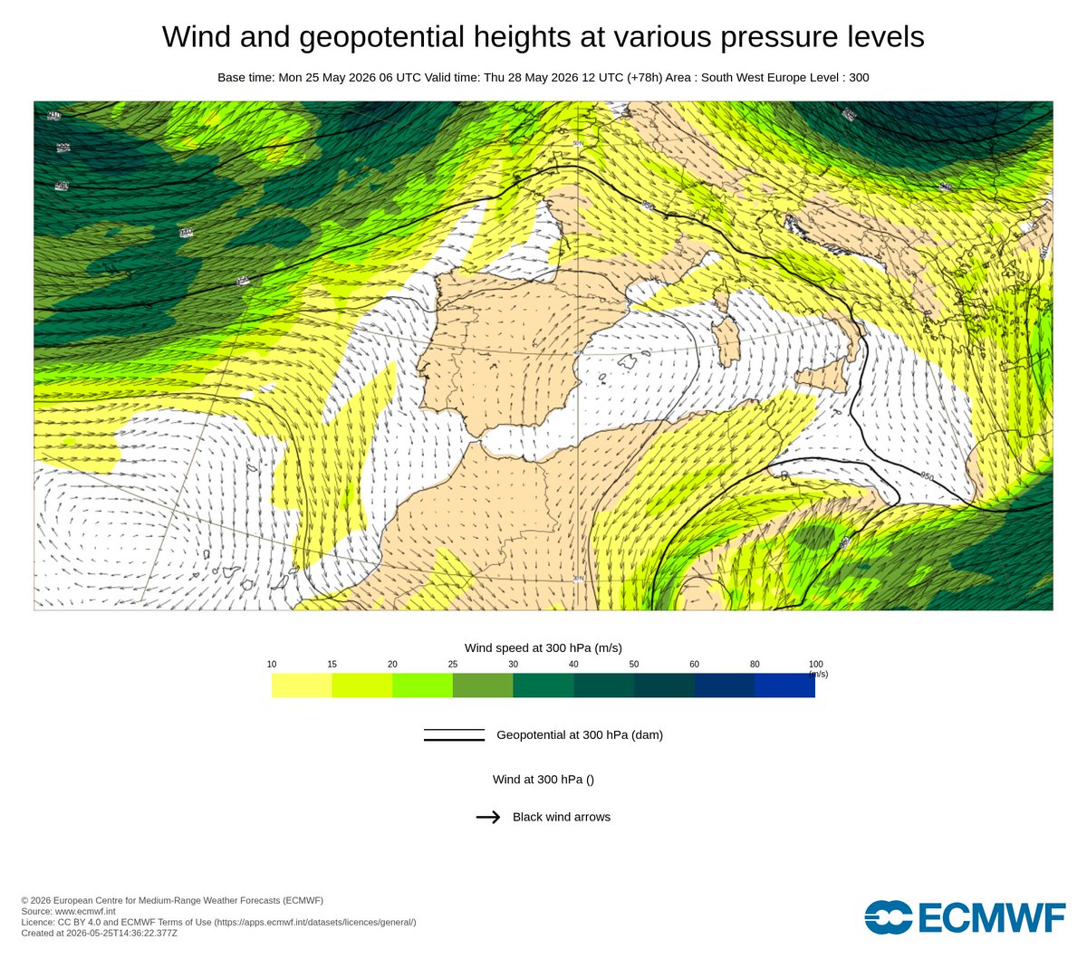
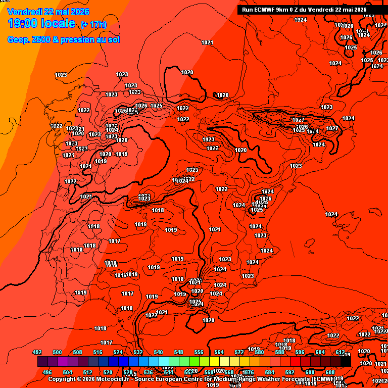
Aparte del calor, podrían darse tormentas entre jueves y viernes en zonas del interior-norte. A ver si identificáis la causante de la posible inestabilidad. Pista: es pequeñita y está embebida en la dorsal
Roberto Granda tweet mediaRoberto Granda tweet media
Español
1
1
3
694
Roberto Granda
Roberto Granda@EnMet3·
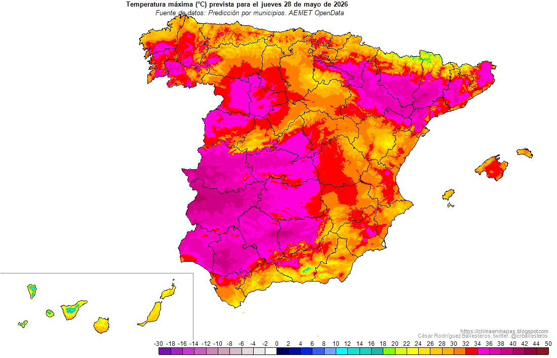
El calor de siempre! Las máximas previstas el jueves serán notablemente superiores a las máximas habituales de un mes de julio en todo el país, pero con especial incidencia en el norte. Y así varios días... Mapas vía @crballesteros Izq: Tmax julio / Der: Tmax jueves 28
Roberto Granda tweet mediaRoberto Granda tweet media
Español
15
60
172
13.3K
Roberto Granda
Roberto Granda@EnMet3·
Hasta las 17:30, así queda el top de máximas nacional. Otro día con casi 38 ºC en el suroeste. A su vez, numerosos récords batidos ya (estaciones +10 años). Destaca Oviedo, que revienta en +1.3ºC su récord de ayer😅
Roberto Granda tweet mediaRoberto Granda tweet media
Español
0
7
30
1.9K
Roberto Granda
Roberto Granda@EnMet3·
@FlorentinoMair1 @CarlosCarpioNa1 ¿Quizás por que no destaca tanto como una estación con 54 años? Aparte, no me paso el día mirando las herramientas cuando no hay nada destacable. Por cierto, ayer no fue 1, fueron al menos 4. Pero sé que contar es difícil, ánimo con ello, algún día podréis.
Español
1
0
0
36
Florentino Mairena
Florentino Mairena@FlorentinoMair1·
@EnMet3 @CarlosCarpioNa1 Y ese uno no lo publicaste? Cuando has publicado el de calor era el primero del mes. Ahora vienes con varios más que han sido posteriores.
Español
1
0
0
24
Roberto Granda
Roberto Granda@EnMet3·
Oviedo ha batido, hasta las 16:00, su récord para un mes de mayo en +1.8 ºC. 34.2 ºC frente a 32.4 ºC
Roberto Granda tweet media
Español
11
19
70
25.8K
Roberto Granda
Roberto Granda@EnMet3·
@Montparnase19 "Cúpula de calor" es un término que no aporta absolutamente nada. La explicación es la existencia de una dorsal + subsidencia, como ha ocurrido en casi todo episodio cálido histórico
Español
0
0
1
41
Roberto Granda
Roberto Granda@EnMet3·
@Montparnase19 Es más, si asciende, implica que se produce un "vacío" que debe compensarse, una baja presión. De hecho, en verano lo normal es tener en los episodios de calor dorsal + baja presión relativa en superficie o neutra, como estos días (+)
Roberto Granda tweet mediaRoberto Granda tweet media
Español
1
0
0
40
Roberto Granda
Roberto Granda@EnMet3·
Como meteorólogo me niego a usar el término "cúpula de calor" (del inglés "heat dome"). Me cansa la inflación del lenguaje. Es absolutamente innecesario. Tendremos una potente dorsal, como es habitual. No hacen falta términos rimbombantes para comunicar la información.
Roberto Granda tweet media
Español
12
16
136
5.7K
Roberto Granda
Roberto Granda@EnMet3·
Las máximas hoy han alcanzado prácticamente los 38 ºC en Badajoz. En Sevilla y Andújar, 37 ºC. Mañana podrían subir 1 ºC o 2 ºC en algunas de estas zonas.
Roberto Granda tweet media
Español
0
5
15
1.2K
Roberto Granda
Roberto Granda@EnMet3·
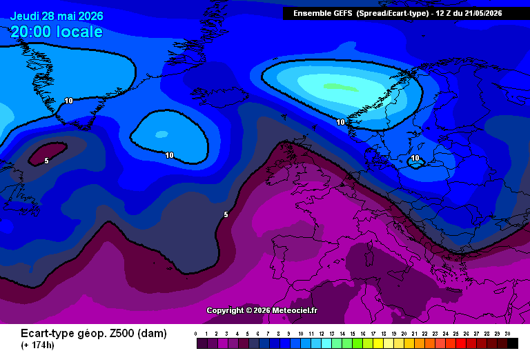
@Statisticizer It is not inconsistent: I talked using the ENS, the probabilistic forecast. You've taken the control member, 1 out of 50+ members, and used it to say something that, from a meteorological forecasting point of view, doesn't sustain (280h...). PD: ensemble maintains for 28th.
Roberto Granda tweet mediaRoberto Granda tweet media
English
1
0
1
106
Hodhodata@statistics
Hodhodata@statistics@Statisticizer·
Dear Roberto, We will continue monitoring the synoptic patterns and see how things converge over the coming days. However, I would appreciate it if you could stop questioning the validity so inconsistently. Just yesterday, you reposted my analysis and stated that there was “zero indication” from the reliable operational models available at the time, which was perfectly fine. Now, suddenly, the tone has shifted to “zero validity.” We Bedouins in the Middle East have a proverb: “We tell them it’s a male goat, and they still ask why it isn’t pregnant.” Please do not argue in that manner, brother. I mentioned you only to inform you, not to provoke or challenge you.
English
1
0
1
87
Hodhodata@statistics
Hodhodata@statistics@Statisticizer·
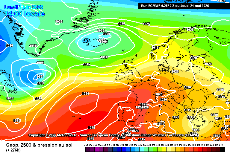
🚨Synoptic classification and statistical analog methods continue to outperform digital models in intermediate to long-range forecasting. A double-trough configuration — (Cyprus Low vs Iberian Low) — characterized by cold intrusions and low-pressure systems, is indicated toward the end of May into early June (≈ 28 May – 3 June) based on the latest ECMWF Thursday update. Oldest forecast here : 👇x.com/Statisticizer/… Further model updates remain important for confirmation. because this trough over Iberia may vary from model to another with respect to its final destination and timing. Note: The success is not mine — it belongs to the methods. No further words needed.
Hodhodata@statistics tweet media
Hodhodata@statistics@Statisticizer

#HeadsUp 🌡️➡️⛈️ Despite the strong heatwave signal currently projected by operational models over parts of central and western Europe, the broader synoptic pattern may become increasingly unstable later in May, with potentially rapid adjustments in upcoming model runs. The current ridge over western Europe ( Barents Sea ) , counteracted by lower geopotential heights near the North Caspian and Ural sector, may eventually favor Rossby-wave amplification and trough detachment toward southwestern Europe and the western Mediterranean — as illustrated by the black arrow. Colder, denser air masses can undercut and displace warm ridging patterns across western Europe, especially under amplified spring flow regimes. This might happen at the same time with formation of Cyprus Low in East Mediterranean sea ( which had materialized yet) . This setup resembles a classical positive North Sea–Caspian dipole (+NCP)-type configuration, a transitional-season pattern that tends to recur more frequently during spring and autumn. If this evolution verifies, cut-off low / #DANA development near Iberia or the Balearic region cannot be ruled out, increasing the likelihood of storminess across inland and northeastern Spain during the final decade of May. The attached 20-analog spring composite also supports the possibility of a colder upper trough/basin forming over the western Mediterranean. At this stage, GFS and ECMWF do not fully support this scenario yet, but the currently projected persistent heat dome may become less stable in subsequent runs. In simpler terms: I broadly agree with Javier ( @Canalcienciaym ) that a transient Rossby-wave amplification during spring should not automatically be interpreted as a long-duration or extreme heatwave regime. Heat waves occur when latent heat builds up over several days while exceeding the high percentile of the period expected temperatures , holding heat into concrete building that radiates heat back at us day and night and persistently for extended period exceeding 4 consecutive days , this pattern is however dynamic and Fastly changing. Indeed the digital models supports this possible scenario at the meantime, a Cyprus Low is expected and it had formed but no Balearic sea Low had formed yet, next few days runs in those models can be very important.

Hashemite Kingdom of Jordan 🇯🇴 English
7
15
72
12.3K
Roberto Granda
Roberto Granda@EnMet3·
@Statisticizer You do see it's a deterministic run for +288 hours, more than 10 days apart, right? 0 validity And it was yesterdays. Just to see, this is todays. 0 validity and doesn't prove anything about statistical models (which don't outperform physic-based models, or we'll be using them)
Roberto Granda tweet mediaRoberto Granda tweet media
English
1
0
1
133
Roberto Granda
Roberto Granda@EnMet3·
@JZzzz8614736 @Jennestudios Veo que no entiendes... con estos días, es el valor estadístico del período 1991-2020 para estos días. El percentil según los datos históricos. Pero bueno, sigue en tus trece, con tal de no aceptar que hace un calor que no es normal, aunque cada vez sea más frecuente.
Español
0
0
0
23
JZug86
JZug86@JZzzz8614736·
@EnMet3 @Jennestudios veas y comprendas de que te hablo. No voy a perder ni un segundo más con alguien que se cree más listo que nadie y que no quiere aprender y prefiere quedarse en entre dicho. P.D: Buenísima fuente la Cibeles para los datos.
Español
2
0
0
89
J.Giner
J.Giner@Jennestudios·
Durante todo el año voy guardando ahorritos poco a poco como una hormiguita. No es para vacaciones, Es para la factura de la luz de junio a agosto, porque trabajo en casa, vivo en Madrid y el aire acondicionado es una absoluta necesidad. Bueno, pues parece que este año me quedo corta :_) xd
Marc Santandreu@marcsansa

A partir del miércoles entraremos en un episodio de #temperaturas altas para la época del año. El pico llegará, previsiblemente, el viernes, con máximas #caniculares en los principales valles del interior👇

Español
30
16
283
102.1K
Roberto Granda
Roberto Granda@EnMet3·
@JZzzz8614736 @Jennestudios Contando con que el p95 estos días en Retiro es ~30.5 ºC y el p99 es ~32ºC, sí, el p97 cae sobre los 31.x ºC. Las escalas son coherentes a la realidad de donde estamos. Si te parece, ponemos en azul 30 ºC. Tendría mucho sentido. El ridículo... con tal de negar la realidad
Español
1
0
0
95
JZug86
JZug86@JZzzz8614736·
@EnMet3 @Jennestudios un 3% de las veces por el espectro alto de la grafica. Antes de dar lecciones de estadística 1 aprende lenguaje y 2 aprende estadística. Porque si supieras de estadística, sabrías que el percentil 50 no es el que se da el 50% de las veces sino el que esta en medio de la +
Español
2
0
0
110
Roberto Granda
Roberto Granda@EnMet3·
@JZzzz8614736 @Jennestudios Emmh... ¿no? Que sea constante quiere decir que, en esta escala específica, 30ºC va a salir en rojo sea enero, mayo, agosto o noviembre. Si no, no sería constante. El percentil 97 es normal, claro. Vuelve a repasar estadística, así como consejo...
Español
1
0
0
128
JZug86
JZug86@JZzzz8614736·
@EnMet3 @Jennestudios Por eso mismo, como es constante no puedes pintar en rojo 30º igual que en agosto vas a pintar los 45º, porque la gente se queda con el color y piensa que estamos a 45º 94 veces en 106 años es casi 1 vez al año. Yo te diría que es bastante normal. Es la definición de normal
Español
1
0
1
256
Roberto Granda
Roberto Granda@EnMet3·
@JZzzz8614736 @Jennestudios La escala de colores es constante todo el año. Por otro, 34 ºC como hoy se han alcanzado en Oviedo no, no son normales ahora: es récord. En Madrid, los 31ºC en mayo sólo se han alcanzado 94 veces desde 1920. Normal, lo que se dice normal... no. Pero es cada vez más frecuente.
Roberto Granda tweet media
Español
1
0
1
283
JZug86
JZug86@JZzzz8614736·
@Jennestudios Partiendo de que si. Somos conscientes de que poner a 30 grados ya todo en rojo Mordor es para crear alarmismo, ¿No? Es calor si, pero no es raro a finales de Mayo llegar algún día a 30 grados
Español
2
0
3
2.4K