Eric Zerkel

5.5K posts

Eric Zerkel

Eric Zerkel

@EricZerkel

supervising weather editor @cnn email: [email protected]

Atlanta Katılım Eylül 2011
2.1K Takip Edilen2.4K Takipçiler
Eric Zerkel retweetledi
Dakota Smith
Dakota Smith@weatherdak·
Absolutely breathtaking view of the Artemis II launch. Wow.
English
21
817
6.5K
259.8K
Dakota Smith
Dakota Smith@weatherdak·
Ok! I am absolutely thrilled to announce I've joined @CNN as a digital meteorologist. I'm so grateful for this opportunity and cannot wait to help the team accomplish some cool stuff!
English
66
12
573
24.2K
Eric Zerkel retweetledi
NWS Mount Holly
NWS Mount Holly@NWS_MountHolly·
6 AM Sun: Light precip is spreading into the region. Mainly rain at the onset from around I-78 and south, then precip will become heavier and transition to snow starting late morning and into the afternoon. Snow for most areas by evening. Latest briefing: weather.gov/media/phi/curr…
English
4
16
96
33.4K
Eric Zerkel retweetledi
Andrew Freedman
Andrew Freedman@afreedma·
NEW: A significant gap in weather balloon coverage in western Alaska, caused by Trump admin cuts to NOAA/NWS, may have hurt the forecast accuracy for the deadly storm there over the weekend. cnn.com/2025/10/14/wea…
English
0
3
5
770
Eric Zerkel retweetledi
Jonathan Petramala
Jonathan Petramala@jpetramala·
Rehoboth Beach, DE, disappearing under surf and surge as a nor'easter continues to cruise up the coast. #noreaster #DEwx #NJwx
English
6
41
258
25.8K
Eric Zerkel retweetledi
Michael Lowry
Michael Lowry@MichaelRLowry·
How about *only* hurricane pairings in the Atlantic and for the entire period of record (since 1851). What are the closest two hurricanes have ever been recorded? Humberto and Imelda right at the top. The nearest reliable contender was Easy and Fox back in 1951.
Michael Lowry tweet media
Kathryn Prociv@KathrynProciv

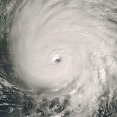
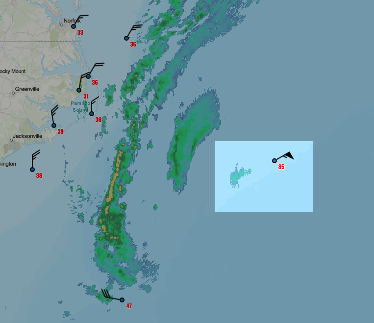
Can't get enough of this stat! #Imelda and #Humberto are the closest two #hurricanes have come to one another in the satellite era. All other cases involved at least one tropical storm!

English
13
72
263
111.3K
Eric Zerkel
Eric Zerkel@EricZerkel·
The track trend from the NHC since #PTC9 was designated on Friday for future #Imelda #TD9
GIF
English
0
1
3
752
Eric Zerkel retweetledi
Jonny Kim
Jonny Kim@JonnyKimUSA·
Hurricane Humberto, Cat 4 (at the time taken), from the @Space_Station, Sept 27, 1512 GMT. Nikon Z9 | 24/50-500mm.
Jonny Kim tweet mediaJonny Kim tweet mediaJonny Kim tweet mediaJonny Kim tweet media
English
68
701
3.3K
298.3K
Eric Zerkel retweetledi
Alex Boreham
Alex Boreham@cyclonicwx·
#Humberto has a meso sector on it now. As a strong Category 4, it has a nice, cleared out stadium effect eye. You can even see the low level clouds spinning around in the eye! Always love the views like this
GIF
English
1
10
120
5K
Eric Zerkel retweetledi
CIRA
CIRA@CIRA_CSU·
The sun sets on Hurricane Humberto. Today, Humberto rapidly intensified into a Category 3, major hurricane.
CIRA tweet media
English
1
20
94
4.3K
Jessica Arnoldy
Jessica Arnoldy@JessicaArnoldy·
Super excited to announce that I’ll be joining the team @weatherstem as their Director of Content and Meteorology
English
6
1
46
1.8K
Jessica Arnoldy
Jessica Arnoldy@JessicaArnoldy·
First day versus last day at the @weatherchannel plus every single tropical storm in the Atlantic Basin since then. Truly a childhood dream to spend nearly 20 years here. I will miss it and the wonderful people I worked with so much!
Jessica Arnoldy tweet mediaJessica Arnoldy tweet mediaJessica Arnoldy tweet media
English
19
2
246
42.7K
Eric Zerkel retweetledi
Jonathan Erdman
Jonathan Erdman@wxjerdman·
NOAA buoy 41001 (~170 mi. E of Hatteras, NC) is in teeth of #Erin. So far, peak gust to 85 mph, with significant wave height of 39.7 feet. With max wave heights usually 2x sig. wave heights, that could mean 80-foot peak waves! Can't wait to see cam photos after sunrise. 🍿
Jonathan Erdman tweet mediaJonathan Erdman tweet media
English
1
5
9
6.7K
Kathryn Prociv
Kathryn Prociv@KathrynProciv·
Hey there! Would you happen to know where I could find a reputable source with information similar to what's on this graphic? Like a list? I can't find what these diameter's are based on, and looking for a more legitimate source anyway. :) Thanks! (Source: youtube.com/watch?v=NoxKH_…)
YouTube video
YouTube
Kathryn Prociv tweet media
English
1
0
3
371
Michael Lowry
Michael Lowry@MichaelRLowry·
Erin is truly an extraordinary hurricane, one of the biggest and most powerful we've seen in this part of the Atlantic. Mercifully it'll spare the U.S. an otherwise extensive and devastating blow, but we won't escape major coastal problems. My latest ⬇️ michaelrlowry.substack.com/p/enormous-eri…
Michael Lowry tweet media
English
3
10
74
14.6K
Eric Zerkel retweetledi
Jonathan Erdman
Jonathan Erdman@wxjerdman·
No two #hurricanes, or their impacts, are exactly alike. But I feel some deja vu seeing the #Erin forecast with Earl almost 15 years ago. Earl was closer to the OBX than Erin's current forecast. But Erin is already larger than Earl was at its closest pass.
Jonathan Erdman tweet media
English
1
2
7
1.1K
Eric Zerkel retweetledi
Michael Lowry
Michael Lowry@MichaelRLowry·
If you think I've forgotten about the hurricane satellites, think again. The Navy is permanently unplugging them this week, on the brink of the busiest stretch of the season. There's so much more to this story, and I have the latest scoop. ⬇️ michaelrlowry.substack.com/p/navy-set-to-…
Michael Lowry tweet media
English
6
84
153
55.2K
Eric Zerkel retweetledi
Kathryn Prociv
Kathryn Prociv@KathrynProciv·
This past week, visualized through river gauges. All 1,000-year #flood events. #Chicago metro also had an extreme flood event last night too, but fortunately rivers are holding. *Hill Country, Texas *Chapel Hill, North Carolina *Ruidoso, New Mexico
Kathryn Prociv tweet mediaKathryn Prociv tweet mediaKathryn Prociv tweet mediaKathryn Prociv tweet media
English
1
5
13
8.6K