
Florent Gravin
136 posts
Florent Gravin
@FGravin
Head of Technology @Camptocamp Map, JS & Mountains enthusiast
Chambéry, France Katılım Mart 2012
438 Takip Edilen109 Takipçiler

Holy shit... Microsoft open sourced an inference framework that runs a 100B parameter LLM on a single CPU.
It's called BitNet. And it does what was supposed to be impossible.
No GPU. No cloud. No $10K hardware setup. Just your laptop running a 100-billion parameter model at human reading speed.
Here's how it works:
Every other LLM stores weights in 32-bit or 16-bit floats.
BitNet uses 1.58 bits.
Weights are ternary just -1, 0, or +1. That's it. No floats. No expensive matrix math. Pure integer operations your CPU was already built for.
The result:
- 100B model runs on a single CPU at 5-7 tokens/second
- 2.37x to 6.17x faster than llama.cpp on x86
- 82% lower energy consumption on x86 CPUs
- 1.37x to 5.07x speedup on ARM (your MacBook)
- Memory drops by 16-32x vs full-precision models
The wildest part:
Accuracy barely moves.
BitNet b1.58 2B4T their flagship model was trained on 4 trillion tokens and benchmarks competitively against full-precision models of the same size. The quantization isn't destroying quality. It's just removing the bloat.
What this actually means:
- Run AI completely offline. Your data never leaves your machine
- Deploy LLMs on phones, IoT devices, edge hardware
- No more cloud API bills for inference
- AI in regions with no reliable internet
The model supports ARM and x86. Works on your MacBook, your Linux box, your Windows machine.
27.4K GitHub stars. 2.2K forks. Built by Microsoft Research.
100% Open Source. MIT License.
English

🚨 BREAKING: AI can now build trading algorithms like Goldman Sachs' algorithmic trading desk (for free).
Here are 15 insane Claude prompts that replace $500K/year quant strats (Save for later)

English
@berttemme What do you do with WMS and interoperability ? What do you do with infras which have 1200 layers, you generate them all in PMTiles cache at every change ?
What do you do with all the ecosystem of applications which can't handle large amount of vector data ?
etc.. 🙃
English

GeoServer 3 Crowdfunding - 550K for switching from Spring 5 to 6? Good time to move to PMTiles/FlatGeobuf geoserver.org/behind%20the%2…
English
@jeffpillou Bravo ! D'où viennent les données ? Qu'est ce qui a été le plus compliqué dans le développement du projet ?
Français

Il y a tout juste un an, je me lançais un défi audacieux : développer, seul, la meilleure application de tourisme au monde (rien que ça) avec des moyens limités, pour me remettre dans les conditions de mes débuts avec CommentCaMarche il y a 25 ans... 1/12
Français
If you develop geospatial web applications, you certainly rely on @opengeospatial #OGC APIs.
To ease your developer journey, give a try to the open source library ogc-client ✨
Read more on linkedin.com/pulse/ogc-clie…
English
Florent Gravin retweetledi

🎉Great news!
📚The complete FOSS4GE program is now available! Remember also to check out the academic track and workshop schedule.👀
❗An early bird discount is available for those who register before May 10!
📌2024.europe.foss4g.org/schedule/talks/
#FOSS4GE2024 #FOSS4GE #FOSS4G

English
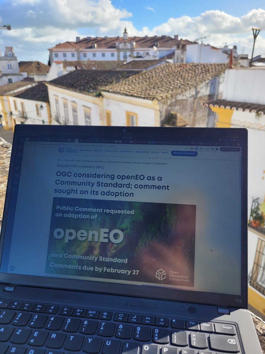
Working on next standards for more interoperable & sustainable systems.
Great weather from Portugal 🇵🇹🌞
#evora @opengeospatial @planetosgeo #GIS @camptocamp
English
@ActuIAFr J'aimerais assister à cette conf mais le formulaire d'inscription ne fonctionne pas (chrome, FF).
Une idée ? Merci
Uncaught TypeError: input is undefined
Français

[#Evenement] 📢🤖 Le Groupe AFNOR vous convie le 1er février à sa conférence « Un cadre de confiance pour l’IA »
actuia.com/actualite/le-g… #IA #intelligenceartificielle
Français
Super journée 🌞
Merci aux organisateurs et hâte de continuer les discussions à la séance CICCLO pour mon anniversaire 🎂
Afigéo 🌐@afigeo_asso_fr
🔴 EN DIRECT de la 2ème partie de notre rencontre #Plateformes et #Innovations ! Au programme : le partage des données via #API ; #Interopérabilité #catalogage au service d'usages : aménagement, transition écologique, biodiversité & conclusion de @ThomasCOTTINET #geodata #FNV✨
Français
Je présenterai "GeoNetwork fait sa révolution" cet après-midi durant l'atelier Qualité, Métadonnées & Catalogues de 14h30.
github.com/opengeospatial…
Aux Journées Interopérabilité et Innovation 2024, sur les principes FAIR ✨
@geonetwork_foss @georchestra @opengeospatial
Français
@github Is this markdown editor opensource somewhere on github ?
English

Slash commands are here to help you write complex markdown faster! 🚀 Learn more by reading our docs: gh.io/slashcommands
English
You can follow what is currently being baked by the geonetwork-ui & Datahub team on the live roadmap github.com/orgs/geonetwor…
Open source first with @geonetwork_foss ! 💫
Thanks to great partnerships and sponsoring
@swisstopo_fr @Geo2France @MetropoleLille 🎉
English
Bravo aux équipes participantes du défi @camptocamp à la #nuitdelinfo23 🌜
- des cartes
- des données ouvertes sur le climat
- des visualisations
Bravo aux gagnants MasterJS pour leur application Globe sur les relevés météo, le look nous a plu !
bastientlc.freeboxos.fr:3000
🌍🌤️
Français
Honoré d'avoir été invité à la 1ère conférence #EastGIS, avec mes confrères @georchestra pour parler données géographiques avec les entités locales, chaleureuses et compétentes.
geoportalksk.sk
Fare well slovakia 🇸🇰
#KSK

Français
ISO TC/211 presentation at @INSPIRE_EU conference for Data spaces.
Actually working on ISO 11915-4 Part. 4 for a JSON schema & implementation.
The end of XML/XSL overhead in @geonetwork_foss ? 🙏
#INSPIRE23 #GreenDataForAll
English
1. geonetwork-ui abstracts schema & directive complexity, for users and maintainers 📄
2. geonetwork-ui works along OGC to provide APIs for data usage, being data-centric 💁
3. The Datahub and the future editor are based on strong UX campain ! 🎨
English
@INSPIRE_EU on the move !
The directive is
1. overly prescriptive
2. of limited use in environmental policy development
3. does not take in consideration evolving user needs
It's "la raison d'être" 💫
of geonetwork-ui & The @Datahub initiatives
👇
#INSPIRE23 #GreenDataForAll
English
Was just chatting with @EvenRouault about using @GdalOrg VRTs format as a basis for data ingestion process !
He validated ! 🤩
@georchestra
English
So happy to have those discussions at @OSGeo code sprint in Vienna 🇦🇹
Very valuable and appreciable 🤩
- fantastic people 🤛
- awesome community 💚
- excellent organization 🌂
- bleeding edge innovation 🚀
#bids @camptocamp
OSGeo https://fosstodon.org/@osgeo@OSGeo
@OSGeo Community Sprint 2023 in Vienna is happening now at #BiDS23. Great opportunity to connect & work together on #OSGeo Software & collaborate. #foss4g You are welcome to join us! osgeo.org/events/join-os…
English