gdal org

134 posts

gdal org

gdal org

@GdalOrg

No longer here. Find us at @[email protected] GDAL is a translator library for raster and vector geospatial data formats.
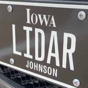
Katılım Nisan 2021
6 Takip Edilen4.4K Takipçiler
gdal org
gdal org@GdalOrg·
By the way, we've moved away from this platform as everybody should, right? Find us at @gdal" target="_blank" rel="nofollow noopener">mastodon.social/@gdal
English
1
1
23
4.5K
gdal org
gdal org@GdalOrg·
#GDAL 3.7.0 is released: lists.osgeo.org/pipermail/gdal… . It includes JSON output for ogrinfo, TileDB vector support, reading of FileGeodatabase raster datasets, @sozip (Seek optimized ZIP) read/write support and many other enhancements and fixes.
English
0
29
65
7.6K
gdal org
gdal org@GdalOrg·
If you use GDAL with Conda, see #issuecomment-1497126647" target="_blank" rel="nofollow noopener">github.com/conda-forge/gd… for instructions to upgrade your existing environment to recent GDAL builds that now use libjpeg-turbo
English
1
8
24
3.3K
gdal org
gdal org@GdalOrg·
Thanks to Kikitte Lee for contributing a new raster->vector polygonizer algorithm, that is up to 10 times faster in some cases: github.com/OSGeo/gdal/pul…
English
1
8
66
9.1K
gdal org
gdal org@GdalOrg·
@pwramsey @postholer Given that @flatgeobuf (at least the GDAL implementation) reorders records to be in the order of the packed Hilbert R-Tree, you would end up rewriting the whole file when changing/appending to it, whatever the location of the index
English
0
0
3
414
Paul Ramsey
Paul Ramsey@pwramsey·
@postholer @GdalOrg Index at front means appending data to end also requires full re-write of all data and index. Index at back means appending data means rewriting index (which you have to do anyways: you just added data).
English
3
0
2
249
gdal org
gdal org@GdalOrg·
All that made possible by us. And practicality of working directly from #shizzle will increase again when @sozipOrg reaches your GDAL build
ShapefiIe (@[email protected])@shapefiIe

Did you know, #geopandas can read and write directly to and from zipped #shapefiles, a.k.a #shizzle files (.shz). #gischat geopandas.org/en/stable/docs…stackoverflow.com/a/67227574​ H/t @ethanwhite/109806959546145546" target="_blank" rel="nofollow noopener">hachyderm.io/@ethanwhite/10…

English
2
9
31
5.9K
Subit Chakrabarti
Subit Chakrabarti@abitmore·
As @floodbase grows to the next level, I want to thank folks to contribute to the open source geospatial ecosystem like @STACspec @GdalOrg @pangeo_data and more. Without the hard work put into those projects, a company like ours (or any that I have worked at) would not exist.
Axios Pro@AxiosPro

Floodbase raised a $12 million Series A round for its flood monitoring service that brings together both satellite and ground-sensor data. trib.al/B8DPrk7

English
1
4
34
4.8K
gdal org retweetledi
sozip
sozip@sozipOrg·
Try me now on @condaforge with @qgis ! conda create --name sozip_test conda activate sozip_test conda install -c gdal-master gdal conda install -c conda-forge qgis And with a @GeoPackage1 file: sozip -j out.gpkg.zip /path/to/in.gpkg qgis out.gpkg.zip
English
0
3
8
1.2K
gdal org
gdal org@GdalOrg·
Thanks to @hobu, our master builds are now available back on Conda on the "gdal-master" channel. All details at #gdal-master-conda-builds" target="_blank" rel="nofollow noopener">gdal.org/download.html#…. Using bleeding edge GDAL has never been so easy
English
0
1
18
2.1K
gdal org
gdal org@GdalOrg·
There are limits to our good will that some have "precisely" exceeded :-) And our abstraction model doesn't necessarily capture all specialized data models.
Postholer - GIS Resources@postholer

@berttemme Core issue from the article, "..but nothing fit our particular needs. So like Google, we embarked upon creating our own specification..", like everyone else. Should a spatial format reach critical mass, standard or not, the great homogenizer @GdalOrg will handle it.

English
2
0
7
2.6K