FloodMapp

1.9K posts

FloodMapp banner
FloodMapp

FloodMapp

@FloodMapp

Real-time flood intelligence for Emergency Managers. Improve safety, prevent damage. #GIS #AI #climatetech #emergencymanagement #resilience

USA / Australia Katılım Şubat 2017
3.4K Takip Edilen3.3K Takipçiler
FloodMapp
FloodMapp@FloodMapp·
💸 Resilience funding is back in focus, and that matters. 🔗 hubs.ly/Q047MPQd0 @fema's decision to relaunch the Building Resilient Communities and Infrastructure (BRIC) program reinforces something many communities already know: Investing in disaster preparedness before the next event is one of the most effective ways to reduce long-term impacts. Programs like BRIC play a critical role in helping states and local governments move from reactive response to proactive resilience planning, supporting projects that strengthen infrastructure, reduce risk, and protect communities over time. But securing this type of funding isn’t just about identifying risk. It’s about clearly demonstrating: 
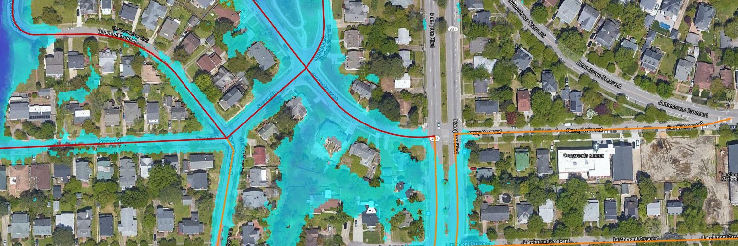
▪️ where impacts are likely to occur ▪️ what assets and communities are exposed ▪️ how mitigation efforts reduce future losses 
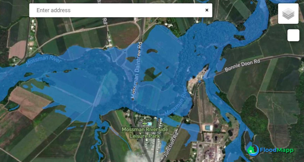
As funding opportunities reopen, the ability to translate flood risk into clear, defensible evidence will be increasingly important for agencies, planners, and infrastructure operators. Resilience isn’t built during disasters—it’s built in the decisions made long before they happen. Learn how FloodMapp can support you: hubs.ly/Q047MPHN0 #FloodResilience #EmergencyManagement #Infrastructure #DisasterPreparedness #FEMA #BRIC #GIS
English
0
0
0
80
FloodMapp
FloodMapp@FloodMapp·
🌀 Cyclone Narelle has crossed the coast, but for many teams, this is where the real work begins. As the system moves inland, the risk often shifts from wind to rainfall, flooding, and loss of access across road networks and communities. 🔗 Follow updates: hubs.ly/Q047L7Bz0 ❓ What if you had visibility into: • where flooding is happening • which roads and assets are being impacted • how conditions are changing hour by hour Having that visibility in real time helps teams make faster, more informed decisions as impacts evolve across large and often remote areas. This phase of an event can last days and extend far beyond the initial landfall zone. If you’re in the path of this system, continue to follow official warnings and stay safe. Learn more about FloodMapp:hubs.ly/Q047L9lY0m #CycloneNarelle #QueenslandWeather #NorthernTerritory #FloodPreparedness #EmergencyManagement #PublicSafety #DisasterResponse
English
0
1
0
75
FloodMapp
FloodMapp@FloodMapp·
The same roads. The same river. Flooded again. As of this morning, March 20, flooding has returned to the Mossman River catchment, with water once again impacting local road networks across the region. 📷 The images below show: • Current on-the-ground flooding conditions, captured via traffic camera • FloodMapp’s NowCast, capturing inundation as it unfolds • Waze alerts, communicating road hazards and closures directly to drivers in real time 🌧️ Less than a week after the previous event, this is a clear reminder of how frequently communities may face repeated impacts during active storm seasons. For those on the ground, the challenge is understanding what is being impacted right now, which roads are inundated, and how conditions may evolve over the next few hours. When that information is visible and accessible, it helps reduce uncertainty and supports safer, more informed decisions. Our thoughts remain with the communities across Far North Queensland managing ongoing impacts this week. Learn more about FloodMapp: hubs.ly/Q047F7C40 #QueenslandFloods #FloodPreparedness #PublicSafety #EmergencyManagement #RoadSafety #GIS #FloodIntelligence
FloodMapp tweet mediaFloodMapp tweet mediaFloodMapp tweet mediaFloodMapp tweet media
English
0
0
0
42
FloodMapp
FloodMapp@FloodMapp·
In the days following last weekend’s flooding across Far North Queensland, the impact on road networks is evident. On Sunday, 15 March, flooding across the Mossman River catchment caused multiple roads to become inundated as water moved through the region. 📷 The images below show: • Real-world flooding across local roads, captured by traffic cameras • FloodMapp’s NowCast, capturing the extent of inundation at the time • Road closure alerts delivered through Waze, helping communicate hazards directly to drivers navigating the area When flooding impacts roads, the risk is immediate. 🚗 Drivers are often the first to encounter dangerous conditions, sometimes with limited visibility, changing water depths, or no clear indication of what lies ahead. ➡️ Integrating real-time flood intelligence into navigation platforms helps bridge that gap, turning evolving conditions into clear, actionable alerts that can help people avoid flooded roads altogether. Recent events across Queensland have been a sobering reminder of how quickly conditions can escalate, and how dangerous floodwaters can be. Our thoughts are with the communities affected, and with those continuing response and recovery efforts across the region. Learn more about FloodMapp: hubs.ly/Q047CxRR0 #QueenslandFloods #PublicSafety #FloodPreparedness #EmergencyManagement #RoadSafety #GIS #FloodIntelligence
FloodMapp tweet mediaFloodMapp tweet mediaFloodMapp tweet mediaFloodMapp tweet media
English
0
0
1
50
FloodMapp
FloodMapp@FloodMapp·
🌀 A major cyclone is expected to impact northern Australia in the coming days. Reports indicate Tropical Cyclone #Narelle could make landfall as a Category 5 system, bringing destructive winds, intense rainfall, and the potential for dangerous flooding across already saturated regions of Queensland and beyond. During events like this, conditions can change quickly. Flooding may not be immediate at landfall, but can develop rapidly as rainfall accumulates, impacting transport networks, isolating communities, and complicating response efforts. For emergency services, infrastructure operators, and communities, the focus is preparation: • understanding where impacts may occur • identifying vulnerable roads and access points • planning for changing conditions over the coming days ➡️ Most importantly, continue to follow official advice and warnings from authorities. Early preparation and informed decisions can make a critical difference. Thinking of the communities in the path of Cyclone Narelle, stay safe. 🔗 Read more: hubs.ly/Q047l0180 #CycloneNarelle #QueenslandWeather #FloodPreparedness #EmergencyManagement #PublicSafety #DisasterResponse
English
0
0
1
135
FloodMapp
FloodMapp@FloodMapp·
🚨 Flood alerts can escalate quickly, and knowing what they mean matters. In this video from The Weather Channel, meteorologist Caitlin Kaiser breaks down the difference between a flood watch, flash flood warning, and flash flood emergency, along with practical safety tips. 🔗 hubs.ly/Q047f4hR0 It’s an important reminder that flood events often develop faster than expected. But during these moments, one question becomes critical: 🔹 What does that alert mean for my specific location? 🔹 Which roads may be impacted? 🔹 Which areas could lose access? 🔹 How quickly might conditions change? Understanding alerts is the first step. Understanding how those alerts translate into real-world impacts is what helps people make safer, more informed decisions. As we’ve seen across recent flood events, having clear visibility into changing conditions can make a meaningful difference for communities, responders, and anyone navigating affected areas. Learn how FloodMapp can help: hubs.ly/Q047dL1X0 #FloodSafety #EmergencyManagement #PublicSafety #FloodAwareness #Weather #Preparedness
English
0
0
1
66
FloodMapp
FloodMapp@FloodMapp·
🌧️ Flooding doesn’t wait for the “right” season. When conditions change, the difference comes down to how quickly teams can understand what’s happening and what it means on the ground. In this on-demand session, we walk through how real-time flood intelligence supports: • faster, more confident decision-making • clearer communication across teams • better visibility into road, asset, and community impacts If your role involves protecting people, infrastructure, or operations during flood events, this is a practical look at how flood data can be used in real-world scenarios. 👀 Watch the recording: hubs.ly/Q0476YD90 #FloodPreparedness #EmergencyManagement #PublicSafety #GIS #Resilience #ClimateTech #FloodForecasting #WeatherTech #TechForGood
FloodMapp tweet media
English
0
0
0
21
FloodMapp
FloodMapp@FloodMapp·
The aerial imagery coming out of Bundaberg this week tells a powerful story. hubs.ly/Q046XJSV0 New footage shared by 9News shows dramatic before-and-after views of the Burnett River flood, revealing just how quickly conditions changed as water moved through the city. Scenes like this highlight the reality that flood events are rarely confined to the river itself. As water spreads across a community, impacts cascade quickly through road networks, neighborhoods, and commercial areas. Our thoughts are with the families affected and the communities continuing recovery efforts across Queensland. Events like this reinforce why communities invest in stronger flood awareness, preparedness, and response capabilities. Understanding where floodwaters may move, which roads may be affected, and how impacts unfold across a city helps agencies make faster decisions that protect lives and keep people out of harm’s way. They also serve as an important reminder of the work still underway to strengthen flood resilience across Queensland communities. Learn how FloodMapp can help: hubs.ly/Q046XYl00 #Bundaberg #QueenslandFloods #FloodAwareness #EmergencyManagement #PublicSafety #FloodPreparedness
English
0
1
1
47
FloodMapp
FloodMapp@FloodMapp·
📷 Bundaberg during last week’s flood peak. On 11 March, the Burnett River reached 7.4m (~24.3ft), bringing widespread flooding across parts of the city. The images below compare real-world flooding at Freedom Fuel along Bourbong Street in central Bundaberg with FloodMapp’s PostCast of the event at peak river levels. 🌧️ Urban flooding like this often unfolds quickly and affects more than just riverbanks. Commercial areas, service stations, access routes, and surrounding neighborhoods can all be impacted as floodwaters move through the local street network. Looking back at events like this helps communities clearly understand: • where floodwater reached within the built environment • which roads and commercial areas were exposed • how flood impacts moved through the city during the event Learn more: hubs.ly/Q046MlxF0 Post-event insight is one of the most valuable tools communities have for improving preparedness, guiding recovery decisions, and strengthening resilience before the next flood occurs. 💚 Our thoughts are with the Bundaberg community and the teams continuing recovery efforts across the region. #Bundaberg #QueenslandFloods #FloodRecovery #EmergencyManagement #UrbanFlooding #GIS #PublicSafety
FloodMapp tweet mediaFloodMapp tweet media
English
0
0
0
103
FloodMapp
FloodMapp@FloodMapp·
🌊 As Virginia Flood Awareness Week continues, communities across the Commonwealth are not only discussing flood risk—they are actively strengthening their ability to prepare for and respond to it. @RiseResilience and FloodMapp bring real-time, impact-based flood forecasting and early warning tools to multiple communities across western Virginia through the Riverine Community Resilience Challenge II. The initiative builds on a successful pilot in Botetourt County and now supports more than 15 agencies and local governments across Planning Districts 4, 5, and 6. ➡️ Learn more about the partnership: hubs.ly/Q046MfGc0 This project is made possible by funding from RISE, which is funded through the Virginia Department of Housing and Community Development. These tools provide a live operational picture of where floodwaters may impact roads, buildings and critical infrastructure across communities. For emergency managers, that visibility helps translate rising river levels into clear, actionable decisions before, during, and after flood events. Flood awareness week is an important reminder that resilience is built long before the next storm arrives. We’re proud to support the communities across Virginia working every day to strengthen flood preparedness and public safety. #VirginiaFloodAwarenessWeek #FloodPreparedness #EmergencyManagement #Resilience #GIS #FloodIntelligence
FloodMapp tweet media
English
0
0
0
43
FloodMapp
FloodMapp@FloodMapp·
🌧️ New on-demand episode drops March 24: 24-Hour Flood Inundation Forecasts When conditions change quickly, leaders need a clearer operational picture. What’s likely to be impacted and what should we do next? Answering these questions earlier helps closures, staging, and public updates stay aligned across teams. Register to receive the viewing link when it’s released: 🔗 hubs.ly/Q046z6fH0 #EmergencyManagement #TechForGood #FloodForecasting #FloodPreparedness #ClimateTech #flooding #PublicSafety
FloodMapp tweet media
English
0
0
0
33
FloodMapp
FloodMapp@FloodMapp·
🌊 Chinchilla yesterday afternoon. Floodwaters moved through parts of the town, as the Chinchilla gauge at Charleys Creek peaked at 8.59 m. The images below show conditions during the event compared with FloodMapp’s PostCast, showing the flood extent during peak river levels. Looking back at events like this helps emergency managers and infrastructure teams better understand: • How flooding moved through the catchment • Which areas were most exposed • Where future response and mitigation efforts should focus Post-event insight is one of the most valuable tools communities have for improving preparedness before the next flood arrives. Learn more: hubs.ly/Q046tFNG0 #Chinchilla #QueenslandFloods #FloodPreparedness #DisasterManagement #PublicSafety #ClimateTech #flooding #WeatherTech #EmergencyManagement
FloodMapp tweet mediaFloodMapp tweet mediaFloodMapp tweet media
English
0
1
1
85
FloodMapp
FloodMapp@FloodMapp·
Another perspective from Bundaberg’s flood peak yesterday, when the Burnett River reached 7.4 m. 📷 The images below compare on-the-ground conditions along Saltwater Creek with FloodMapp’s PostCast of peak flood extent, at the same approximate time. Capturing these moments matters. Understanding exactly where floodwaters travelled, which assets were exposed, and how access routes were affected helps agencies refine response strategies and strengthen resilience planning for the future. Every flood leaves lessons to be learned. Tools that help document and analyze those impacts make those lessons easier to act on. ➡️ Request a demo: hubs.ly/Q046tBgD0 #Bundaberg #FloodRecovery #EmergencyManagement #PublicSafety #GIS #FloodPreparedness #ClimateTech #TechForGood #WeatherTech
FloodMapp tweet mediaFloodMapp tweet mediaFloodMapp tweet media
English
0
2
2
74
FloodMapp
FloodMapp@FloodMapp·
On 11 March, the Burnett River peaked at 7.4 metres, bringing significant #flooding across parts of Bundaberg. The images below compare real-world flooding with FloodMapp’s PostCast reconstruction of peak flood extent, showing how far water reached throughout the area during the event. The final image combines NowCast (current flood conditions) and PostCast, providing additional context as water levels fall. At the time of the image, the Burnett River has dropped to 5.23 metres and is continuing to recede, while impacts across the road network and surrounding areas are still clearly visible. When floodwaters begin to recede, agencies shift focus toward damage assessments, infrastructure inspections, and safely reopening roads and access routes. Having a clear picture of where flooding occurred, and what was impacted, helps teams prioritize resources and coordinate recovery efforts more efficiently. Learn more: hubs.ly/Q046tt_G0 💚 Our thoughts are with the #Bundaberg community and the responders working across the region. #Bundaberg #QueenslandFloods #FloodRecovery #EmergencyManagement #PublicSafety #GIS #DisasterResponse
FloodMapp tweet mediaFloodMapp tweet mediaFloodMapp tweet media
English
0
1
1
52
FloodMapp
FloodMapp@FloodMapp·
🌊 Floods are the most common natural disaster in Virginia. Yet the most dangerous floods often aren’t the largest ones, they’re the ones that happen fast and locally. This week is Virginia Flood Awareness Week, led by the Virginia Department of Conservation and Recreation to help communities better understand flood risk and preparedness. Across Virginia’s mountains, valleys, and coastal regions, flooding can look very different, but the challenge is the same: seeing risk early enough to act. For emergency managers, transportation agencies, and local leaders, preparedness today means understanding not just how high rivers might rise, but what those levels mean for roads, communities, and response operations. That awareness helps communities prepare, respond faster, and recover stronger. Learn more about Virginia Flood Awareness Week: 🔗 hubs.ly/Q046py5l0 #VirginiaFloodAwarenessWeek #FloodPreparedness #EmergencyManagement #ResilientCommunities #Virginia
GIF
English
0
0
0
30
FloodMapp
FloodMapp@FloodMapp·
🌧️ A major flood warning has been issued for the Burnett River at Bundaberg, with authorities advising that river levels are expected to rise significantly through the day. hubs.ly/Q04672fT0 Moments ago, the river was sitting at 5.42m, with ForeCast indicating that it could reach major flood stage (around 7m) later this evening if conditions continue as expected. The images below show how conditions are evolving across #Bundaberg: ▪️ NowCast (blue) showing current inundation along the Burnett River and 24-hour ForeCast (yellow) highlighting where flooding may expand if river levels reach the predicted peak ▪️ FloodMapp casts indicating impacted roads, including Que Hee Street, where water is already affecting the roadway ▪️ Real-world imagery from Bundaberg, including flooding near the Sandy Hook Ski Club and along Que Hee Street, confirming conditions on the ground For communities, asset owners, and emergency teams, the challenge during events like this isn’t simply knowing the river level, it’s understanding what those levels mean on the ground. ❓ Which roads may be affected? ❓ Which properties or facilities are exposed? ❓ How quickly might conditions change? Translating river forecasts into clear visibility of potential impacts helps organizations position resources, communicate risks earlier, and protect people and assets as conditions evolve. Learn more: hubs.ly/Q0466ZXT0 We’ll be continuing to monitor conditions today. Stay safe, Bundaberg. #Bundaberg #BurnettRiver #QueenslandFloods #FloodPreparedness #EmergencyManagement #PublicSafety #FloodIntelligence #TechForGood
FloodMapp tweet mediaFloodMapp tweet mediaFloodMapp tweet mediaFloodMapp tweet media
English
0
2
2
221
FloodMapp
FloodMapp@FloodMapp·
🌧️ Yesterday, inundation was building along Burke Developmental Road in Corduroy. The images below show FloodMapp’s NowCast displayed alongside imagery from the nearby Windy Webcam (location marked by a green circle in the NowCast image) as water approached moderate flood stage. At this stage, the value of real-time flood intelligence is clear: it helps organizations understand not just that water levels are rising, but what that means for roads, access, and operations on the ground. This comparison shows how operational flood intelligence can support real-world awareness when timing matters most. For teams responsible for protecting people, road networks, and critical assets, that visibility supports earlier and more confident decisions—whether that means adjusting access, communicating risk, or repositioning resources before conditions worsen. ➡️ Request a demo: hubs.ly/Q0466RW00 #FloodIntelligence #FloodPreparedness #RoadSafety #EmergencyManagement #FloodForecasting #QueenslandFloods #GIS
FloodMapp tweet mediaFloodMapp tweet media
English
0
1
0
67
FloodMapp
FloodMapp@FloodMapp·
🌧️ Queensland is seeing widespread road closures as flooding continues across multiple regions. hubs.ly/Q04628HL0 Lists like this one from The Courier-Mail are an important way to keep communities informed, but they also highlight how quickly flood impacts can spread across a road network. For emergency managers and local councils, the real challenge is understanding which roads are likely to be impacted next, and how those closures affect access, detours, and response routes across the wider network. Flood intelligence that shows street-level impact mapping helps decision-makers move from reacting to closures to anticipating them. When agencies can see how water is likely to affect roads, bridges, and surrounding infrastructure, they can communicate earlier, manage detours more effectively, and help keep drivers out of dangerous floodwaters. ➡️ Learn more: hubs.ly/Q04628FX0 #QueenslandFloods #RoadClosures #FloodPreparedness #EmergencyManagement #PublicSafety #FloodIntelligence
English
0
1
0
43
FloodMapp
FloodMapp@FloodMapp·
You already have sensors, models, and historical studies, but can your tools keep up when flood conditions shift quickly? FloodMapp delivers the operational flood intelligence you need to act early and confidently, from planning to response to recovery. ✅ Predict how and where floodwaters will rise—before it happens ✅ Maintain live situational awareness as conditions evolve ✅ Strengthen coordination across teams and partners And do it all in your existing systems, no new tools required. Because in flood response, clarity isn’t optional it’s lifesaving. 📍 See how operational flood intelligence empowers faster, smarter decisions: hubs.ly/Q045VqWb0 #EmergencyManagement #FloodPreparedness #FloodForecasting #Resilience #flood #ClimateTech #TechForGood #GIS
GIF
English
0
0
0
34
FloodMapp
FloodMapp@FloodMapp·
Flooding in the mountains can escalate quickly, and impacts can vary dramatically across neighboring communities. That’s why we’re excited to bring real-time, impact-based flood forecasting and early warning tools to communities across western Virginia. This project, made possible by @RiseResilience and funded through the Virginia Department of Housing and Community Development, will help strengthen flood preparedness and situational awareness. The initiative builds on a successful pilot in Botetourt County and is now expanding to support more than 15 agencies and local governments across the region. Participating jurisdictions receive customized ArcGIS-integrated dashboards that show where roads, buildings, and other assets may be impacted, helping leaders position resources, adjust closures, and communicate clearly with the public. Read the full announcement: 🔗 hubs.ly/Q045LXSQ0 #EmergencyManagement #FloodPreparedness #VirginiaResilience #PublicSafety #FloodForecasting #WeatherTech #TechForGood #flooding
FloodMapp tweet media
English
0
0
0
51