GeoConfirmed

32.4K posts

GeoConfirmed banner
GeoConfirmed

GeoConfirmed

@GeoConfirmed

Map and Investigations = https://t.co/B93nqcHOaM Managed by volunteers.

Katılım Mart 2022
276 Takip Edilen229.2K Takipçiler
Sabitlenmiş Tweet
GeoConfirmed
GeoConfirmed@GeoConfirmed·
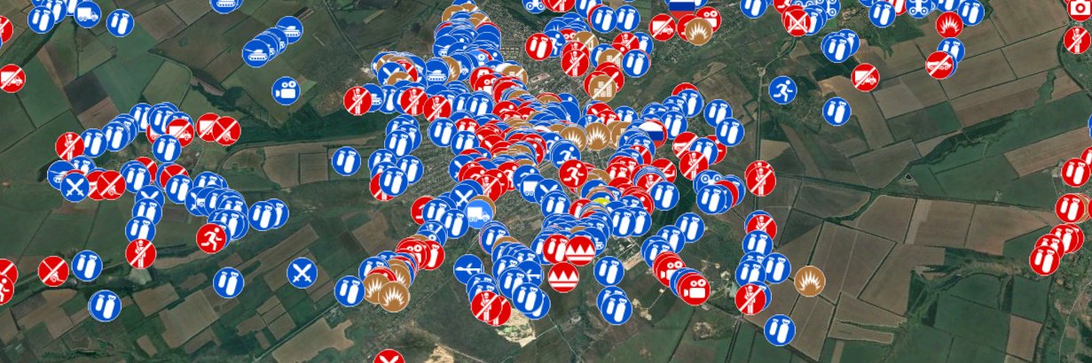
The State of the "X" OSINT Community, a message to the 'OSINT' accounts. Let’s all take a step back and look at the broader “OSINT” community, especially after Elon Musk’s changes. What do we actually see? Engagement Farmers. The majority of these accounts claim to do OSINT and even include it in their name. But most of them don’t do the work. At best, they’re bad news aggregators — copying and pasting information without citing sources, rewriting descriptions to grab attention, and shaping opinions based on unverified data. They chase attention, not accuracy. In other words, they’re engagement farmers. These accounts make up most of what’s now labeled as “OSINT.” News aggregators. Then there’s a second group — the news aggregators who at least add some value. They collect and organize information into threads or perform basic analyses that make data easier to understand. Importantly, they also give proper credit to the original sources. For them, it’s not about being the first to post — it’s about gathering reliable information and presenting it clearly and responsibly. OSINT. Finally, there are the 'real' OSINT accounts. A definition: "OSINT is the practice of collecting, analyzing, and interpreting publicly available information from open sources to produce insights for decision-making, threat assessment, and investigations." The real OSINT accounts go beyond aggregation. They verify locations, identify equipment types, and perform full investigations — turning raw data into actionable, verified insights. Mistakes. And yes, even OSINT accounts make mistakes. Why? Because OSINT is only as accurate as the information available at the time of analysis. That’s why verifying the basic data used in any analysis must always be a priority. Crediting sources is equally important — it allows others to understand the reasoning behind the analysis and, if necessary, to verify the same sources independently. When new information emerges, earlier conclusions may turn out to be flawed. It’s then the responsibility of the OSINT account to evaluate whether the new data impacts the final assessment. If it does, the correct course of action is clear: delete the original post and start again. Deletion is the only acceptable response when an error alters the conclusion. GeoConfirmed. We know where we stand: GeoConfirmed is a verification community of more than 100 volunteers, dedicated to answering factual “where” questions. Does that make us an OSINT account? That’s not for us to decide. In four years, GeoConfirmed has made seven mistakes — just seven. Each time, we reviewed our verification process, because seven out of more than 60,000 published geolocations is still seven too many. That’s the level of responsibility our admin team has committed to. We guarantee where something happened — not what happened, and not when. With the exemption for our 'investigations' where we used the geolocation as a basis for a further analysis. And in every one of those seven cases, we deleted our tweets and posted corrections. How many accounts, even 'OSINT' accounts, get fact-based feedback, even Community Notes, but never make corrections? For them, it’s not about the facts. The initial tweet draws attention — and that’s what matters most to them. How to handle mistakes. Everyone can make mistakes. There is only one correct response to a mistake: delete the tweet and post a new one with the correction. Let’s be very clear about this. Accounts that post a “correction” in a follow-up tweet are still benefiting from the attention generated by the original post. They aren’t prioritizing facts — they’re preserving engagement. The correction will never reach as many people as the original tweet, meaning the misinformation or disinformation continues to spread. Deleting the mistaken tweet and reposting it with the correct information is the only responsible solution. --- So, if you call yourself an OSINT account, ask yourself this: Am I part of the third group? Am I doing what should be expected from an OSINT account? If the answer is no, then you are not an OSINT account and shouldn’t present yourself as one. Unless you take concrete steps to meet the standards of real OSINT work, you’re not contributing to the field: you’re merely chasing attention under a false label. That doesn’t make you an OSINT account — it makes you a fraud, using OSINT for attention, and adding noise instead of value. --- Pictured: GeoConfirmed’s admin team verified geolocations conducted by the GeoConfirmed volunteer community, as well as contributions from other volunteers, related to the Ukraine–Russia conflict. Over 50,000+ GeoConfirmed locations where events occured. (geoconfirmed.org/ukraine)
GeoConfirmed tweet media
English
106
476
3.3K
543.4K
GeoConfirmed
GeoConfirmed@GeoConfirmed·
2.
GeoConfirmed@GeoConfirmed

GeoConfirmed Information. With GeoConfirmed we aim to support and strengthen the OSINT community: the genuine OSINT community, not the engagment farmers using 'OSINT' for attention (and the money it provides). In addition to our core work on conflict-related mapping, where we provide source attribution and verified geolocations produced by the broader geolocation community, we are also developing several complementary projects: We are gratefull for @UAControlMap, whose frontline tracking is embedded in our Ukraine conflict map. We are also building an order of battle (ORBAT) system to connect mapped locations with the units involved. For the Ukraine conflict map, this effort is made possible thanks to @WarUnitObserver. In parallel, we are developing an equipment overview thanks to armsnet.app. Together, these three elements now make it possible to link a single location with specific units and equipment. Finally, we are in the final stages of developing a curated bookmark page "GeoConfirmed Toolkit" featuring geolocation / OSINT tools (see image). Through these initiatives, we aim to contribute meaningfully to the OSINT community. Our website is geoconfirmed.org. By logging in, you gain full access to all available features (some not implemented yet). We do not collect information about your location, nor do we use advertising or tracking cookies. Your privacy is a priority for us. GeoConfirmed is currently looking for additional volunteers: Priority: Information managers (responsible for verifying and adding data to our maps) [Our backlog keeps getting bigger] Others: - Geolocators - ORBAT specialists - Equipment analysts If you are interested in contributing to our work, please send us a private message via our channel, but: Objectivity is one of our core principles. We do not seek or support engagement-driven contributors or individuals primarily motivated by the attention associated with GeoConfirmed. All new volunteers undergo a trial period and are only accepted upon approval by the GeoConfirmed admin team. We would like to express our gratitude to @bellingcat, @Cen4infoRes, @BBC Verify, @snopes, and similar projects. They are OSINT beacons in a world filled with disinformation and misinformation. We are also very grateful to all volunteer geolocators for their invaluable contributions. THANKS! Keep up the good work. PS: Everything is a continuous work in progress: the ORBATs, toolkit, equipment overview, and map will never be fully finished.

QST
0
0
7
4.4K
GeoConfirmed
GeoConfirmed@GeoConfirmed·
The State of the "X" OSINT Community, a message to the 'OSINT' accounts. Let’s all take a step back and look at the broader “OSINT” community, especially after Elon Musk’s changes. What do we actually see? Engagement Farmers. The majority of these accounts claim to do OSINT and even include it in their name. But most of them don’t do the work. At best, they’re bad news aggregators — copying and pasting information without citing sources, rewriting descriptions to grab attention, and shaping opinions based on unverified data. They chase attention, not accuracy. In other words, they’re engagement farmers. These accounts make up most of what’s now labeled as “OSINT.” News aggregators. Then there’s a second group — the news aggregators who at least add some value. They collect and organize information into threads or perform basic analyses that make data easier to understand. Importantly, they also give proper credit to the original sources. For them, it’s not about being the first to post — it’s about gathering reliable information and presenting it clearly and responsibly. OSINT. Finally, there are the 'real' OSINT accounts. A definition: "OSINT is the practice of collecting, analyzing, and interpreting publicly available information from open sources to produce insights for decision-making, threat assessment, and investigations." The real OSINT accounts go beyond aggregation. They verify locations, identify equipment types, and perform full investigations — turning raw data into actionable, verified insights. Mistakes. And yes, even OSINT accounts make mistakes. Why? Because OSINT is only as accurate as the information available at the time of analysis. That’s why verifying the basic data used in any analysis must always be a priority. Crediting sources is equally important — it allows others to understand the reasoning behind the analysis and, if necessary, to verify the same sources independently. When new information emerges, earlier conclusions may turn out to be flawed. It’s then the responsibility of the OSINT account to evaluate whether the new data impacts the final assessment. If it does, the correct course of action is clear: delete the original post and start again. Deletion is the only acceptable response when an error alters the conclusion. GeoConfirmed. We know where we stand: GeoConfirmed is a verification community of more than 100 volunteers, dedicated to answering factual “where” questions. Does that make us an OSINT account? That’s not for us to decide. In four years, GeoConfirmed has made seven mistakes — just seven. Each time, we reviewed our verification process, because seven out of more than 60,000 published geolocations is still seven too many. That’s the level of responsibility our admin team has committed to. We guarantee where something happened — not what happened, and not when. With the exemption for our 'investigations' where we used the geolocation as a basis for a further analysis. And in every one of those seven cases, we deleted our tweets and posted corrections. How many accounts, even 'OSINT' accounts, get fact-based feedback, even Community Notes, but never make corrections? For them, it’s not about the facts. The initial tweet draws attention — and that’s what matters most to them. How to handle mistakes. Everyone can make mistakes. There is only one correct response to a mistake: delete the tweet and post a new one with the correction. Let’s be very clear about this. Accounts that post a “correction” in a follow-up tweet are still benefiting from the attention generated by the original post. They aren’t prioritizing facts — they’re preserving engagement. The correction will never reach as many people as the original tweet, meaning the misinformation or disinformation continues to spread. Deleting the mistaken tweet and reposting it with the correct information is the only responsible solution. --- So, if you call yourself an OSINT account, ask yourself this: Am I part of the third group? Am I doing what should be expected from an OSINT account? If the answer is no, then you are not an OSINT account and shouldn’t present yourself as one. Unless you take concrete steps to meet the standards of real OSINT work, you’re not contributing to the field: you’re merely chasing attention under a false label. That doesn’t make you an OSINT account — it makes you a fraud, using OSINT for attention, and adding noise instead of value. --- Pictured: GeoConfirmed’s admin team verified geolocations conducted by the GeoConfirmed volunteer community, as well as contributions from other volunteers, related to the Ukraine–Russia conflict. Over 50,000+ GeoConfirmed locations where events occured. (geoconfirmed.org/ukraine)
GeoConfirmed tweet media
English
106
476
3.3K
543.4K
GeoConfirmed
GeoConfirmed@GeoConfirmed·
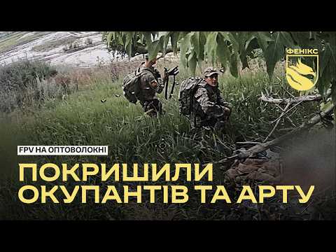
GeoConfirmed conflictmap UKR. 0:29-0:37 - A Russian KamAZ-53949 "Typhoon-L" armoured truck was destroyed by Ukrainian FPV drone. 48.34693, 37.462395 8GWV8FW6+QX Malynivka, Donetsk Oblast, Ukraine GeoLocated by @99Dominik_ Reported involved units: Unmanned Systems Regiment "Phoenix" ▸ Ukrainian Unmanned Systems Forces (SBS/USF) Geolocation: x.com/99Dominik_/sta… Location: geoconfirmed.org/ukraine/78cc10… Sources: x.com/PuenteUribarri… youtube.com/watch?v=JCLw3v… t.me/feniksdpsu/2151 Equipment Id: ukr.warspotting.net/view/45892/ Visit our map: geoconfirmed.org/map/ukraine
YouTube video
YouTube
Manu@PuenteUribarri

Trabajo de la Unidad de Sistemas No Tripulados "Phoenix"🇺🇦, blindados, artillería, rusos… t.me/feniksdpsu/2151

English
2
8
25
8K
GeoConfirmed
GeoConfirmed@GeoConfirmed·
GeoConfirmed conflictmap UKR. The Russian FSB Patrol Ship Izumrud is destroyed in a little harbor near Gelendzhik, Krasnodar Krai, Russia, 20km from Novorossiysk. 44.56468, 37.99335 8GPVHX7V+V8 Gelendzhik, Krasnodar Krai, Russia GeoLocated by @GravinaDominic, @neonhandrail and @WritingFates Reported involved units: Rubin-class Patrol Boat "Izumrud" ▸ Russian Armed Forces Geolocation: x.com/GravinaDominic… x.com/neonhandrail/s… x.com/WritingFates/s… Location: geoconfirmed.org/ukraine/8366de… Sources: x.com/UA_NAVY/status… t.me/ukrainian_navy… Some history about the Izumrud: x.com/bayraktar_1lov… Visit our map: geoconfirmed.org/map/ukraine
Військово-Морські Сили ЗС України@UA_NAVY

🇺🇦⚓ Супутниковий знімок підтверджує знищення російського прикордонного сторожового корабля «Ізумруд» біля причальної стінки. Продовжуємо знижувати потенціал російського агресора на морі💪

Română
1
5
29
7.5K
GeoConfirmed
GeoConfirmed@GeoConfirmed·
GeoConfirmed conflictmap UKR. Point of view - The Russian FSB Patrol Ship Izumrud is destroyed in a little harbor near Gelendzhik, Krasnodar Krai, Russia, 20km from Novorossiysk 44.599167, 38.032556 8GPWH2XM+M2 Gelendzhik, Krasnodar Krai, Russia GeoLocated by @Grimm_Intel Reported involved units: Rubin-class Patrol Boat "Izumrud" ▸ Russian Armed Forces Geolocation: x.com/Grimm_Intel/st… Location: geoconfirmed.org/ukraine/8f32a3… Sources: x.com/Grimm_Intel/st… t.me/exilenova_plus… Visit our map: geoconfirmed.org/map/ukraine
Rocket Man🚀🇺🇸🇺🇦@Grimm_Intel

The FSB Coast Guard Patrol Ship was hit in the military port in Gelendizhik, causing extrensive damage. 44.564540°N 37.993534°E Pic 1 source t.me/exilenova_plus… Pic 2 source t.me/ukrainian_navy… Geolocations in replies

English
1
4
18
6.6K
GeoConfirmed
GeoConfirmed@GeoConfirmed·
GeoConfirmed Information. With GeoConfirmed we aim to support and strengthen the OSINT community: the genuine OSINT community, not the engagment farmers using 'OSINT' for attention (and the money it provides). In addition to our core work on conflict-related mapping, where we provide source attribution and verified geolocations produced by the broader geolocation community, we are also developing several complementary projects: We are gratefull for @UAControlMap, whose frontline tracking is embedded in our Ukraine conflict map. We are also building an order of battle (ORBAT) system to connect mapped locations with the units involved. For the Ukraine conflict map, this effort is made possible thanks to @WarUnitObserver. In parallel, we are developing an equipment overview thanks to armsnet.app. Together, these three elements now make it possible to link a single location with specific units and equipment. Finally, we are in the final stages of developing a curated bookmark page "GeoConfirmed Toolkit" featuring geolocation / OSINT tools (see image). Through these initiatives, we aim to contribute meaningfully to the OSINT community. Our website is geoconfirmed.org. By logging in, you gain full access to all available features (some not implemented yet). We do not collect information about your location, nor do we use advertising or tracking cookies. Your privacy is a priority for us. GeoConfirmed is currently looking for additional volunteers: Priority: Information managers (responsible for verifying and adding data to our maps) [Our backlog keeps getting bigger] Others: - Geolocators - ORBAT specialists - Equipment analysts If you are interested in contributing to our work, please send us a private message via our channel, but: Objectivity is one of our core principles. We do not seek or support engagement-driven contributors or individuals primarily motivated by the attention associated with GeoConfirmed. All new volunteers undergo a trial period and are only accepted upon approval by the GeoConfirmed admin team. We would like to express our gratitude to @bellingcat, @Cen4infoRes, @BBC Verify, @snopes, and similar projects. They are OSINT beacons in a world filled with disinformation and misinformation. We are also very grateful to all volunteer geolocators for their invaluable contributions. THANKS! Keep up the good work. PS: Everything is a continuous work in progress: the ORBATs, toolkit, equipment overview, and map will never be fully finished.
GeoConfirmed tweet mediaGeoConfirmed tweet mediaGeoConfirmed tweet media
English
1
14
57
10.5K
GeoConfirmed
GeoConfirmed@GeoConfirmed·
GeoConfirmed conflictmap Iran. A US strike hit the Telecommunications Regulatory Authority building in Bandar Abbas, Iran. 27.19285, 56.25788 7HVR57V5+45 Bandar Abbas, Hormozgan Province, Iran GeoLocated by @zarGEOINT Reported involved units: United States Air Force ▸ United States Department of Defense (DOD) ▸ United States Armed Forces Geolocation: x.com/zarGEOINT/stat… Location: geoconfirmed.org/iran/aab8cd40-… Sources: x.com/zarGEOINT/stat… t.me/VahidOnline/77… Visit our map: geoconfirmed.org/map/iran
Zaryon OSINT@zarGEOINT

🇮🇷🇺🇸🔴 A US strike hit the Telecommunications Regulatory Authority building in Bandar Abbas, Iran, last night. 📍 Geolocation: 27.19285, 56.25788 @GeoConfirmed @FaytuksNetwork @hey_itsmyturn 1/2

English
1
5
15
7.9K
GeoConfirmed
GeoConfirmed@GeoConfirmed·
GeoConfirmed conflictmap Iran. Fire and smoke in southern Kish Island, near the International Passenger Ferry Terminal. 26.56468, 53.99729 7HRMHX7W+VM Kish, Hormozgan Province, Iran GeoLocated by @GhonchehAzad, @zarGEOINT, @KJ_X23 and @mostly_zakhim Geolocation: x.com/GhonchehAzad/s… x.com/zarGEOINT/stat… x.com/KJ_X23/status/… x.com/mostly_zakhim/… Location: geoconfirmed.org/iran/d2626078-… Sources: (2/2) x.com/Vahid/status/2… x.com/zarGEOINT/stat… Visit our map: geoconfirmed.org/map/iran
Vahid Online@Vahid

تصاویر دریافتی با شرح: '#کیش، سه‌شنبه ۲۳ تیر ساعت ۰۰:۳۸' #Iran

English
1
5
19
7.7K
GeoConfirmed
GeoConfirmed@GeoConfirmed·
GeoConfirmed conflictmap DRC. Sanctioned Twirwaneho armed group-General Charles Sematama with AFC leaders near the Minembwe Local Government Office. -3.934227, 28.730813 6G8C3P8J+88 Minembwe, Democratic Republic of the Congo GeoLocated by @Zeldamices Reported involved units: Twirwaneho rebel group [DRC] ▸ Great Lakes Region Factions M23 [DRC] ▸ Great Lakes Region Factions Geolocation: x.com/Zeldamices/sta… Location: geoconfirmed.org/drc/22196290-d… Sources: x.com/Col_Alimasi/st… x.com/TwirwanehoMois… More information opensanctions.org/entities/NK-Ze… Visit our map: geoconfirmed.org/map/drc
Col_Alimasi@Col_Alimasi

Les leaders de l’AFC-M23 et de Twirwaneho effectuent une marche à pied à Minembwe et à Point Zéro avec sérénité, sans inquiétude.

English
1
2
11
8.3K