LeBron in Game 1… 27, 6, & 4
LeBron in Game 2… 23, 6, & 2
LeBron in Game 3… 19, 8, & 6
LeBron in Game 4… 24, 12, & 3
He is still elite at 41 years old.
He is by far the greatest of all-time.
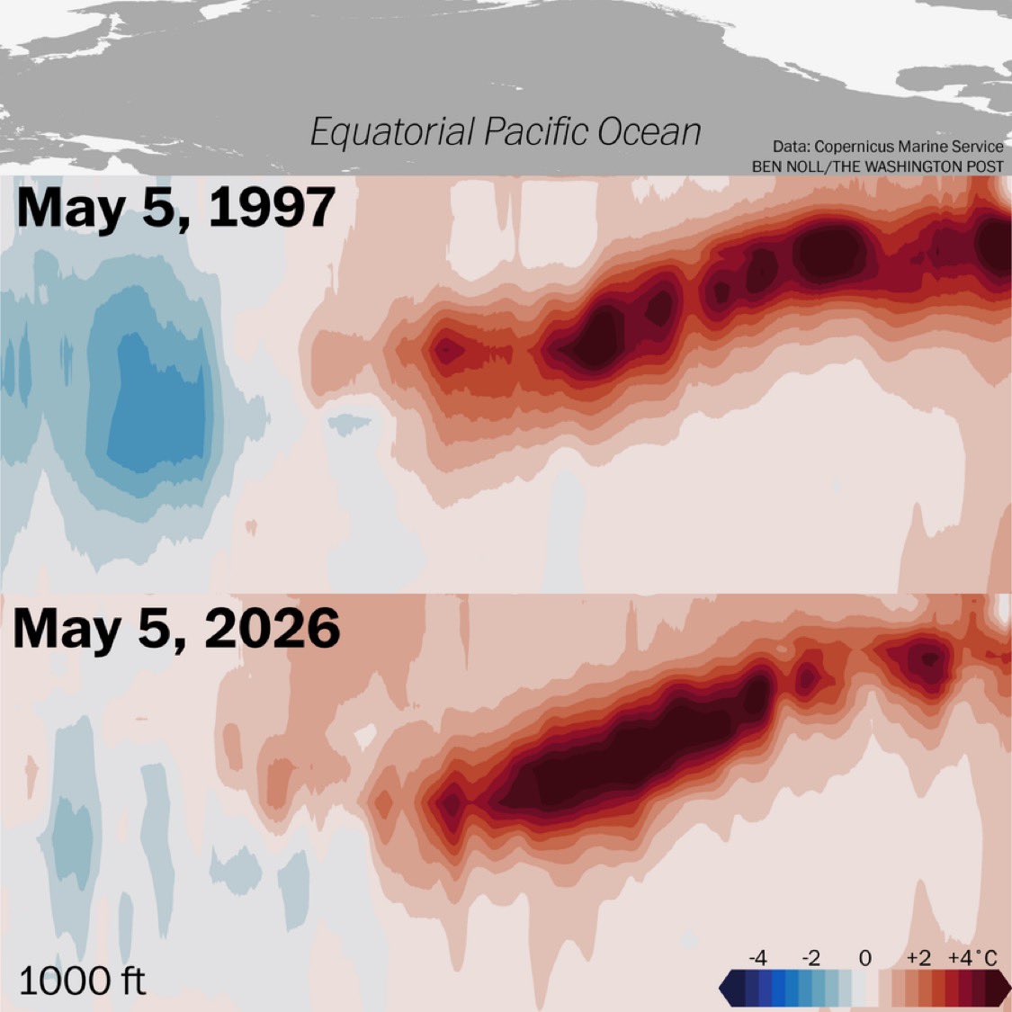
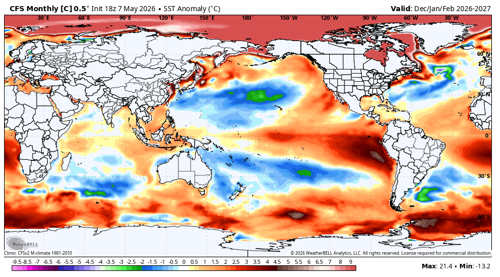
El Fenómeno del niño 2026 se está pareciendo mucho al del 1997.
No son idénticos, pero tienen muchas similitudes.
Aguas excepcionalmente cálidas estaban más cerca de la superficie del Océano Pacífico en ese momento en 1997, pero 2026 está rompiendo récords de calor en profundidad.
¿Será superior igual o menor al 97?
@RealSkipBayless What you mean give this one to Minnesota? It’s 82-75 Spurs with 2 mins to go in the 3rd. Spurs can handle this. It’s 3-1 after this one.
COME ON, DON'T THROW WEMBANYAMA OUT OF A GAME 4. THEY WERE ALL OVER HIM, FOULING THE HELL OUT OF HIM. SO HE GOT FRUSTRATED AND FOUGHT BACK. JUST RIDICULOUS. JUST GIVE MINNESOTA THIS ONE. 2-2 GOING BACK TO SAN ANTONIO.
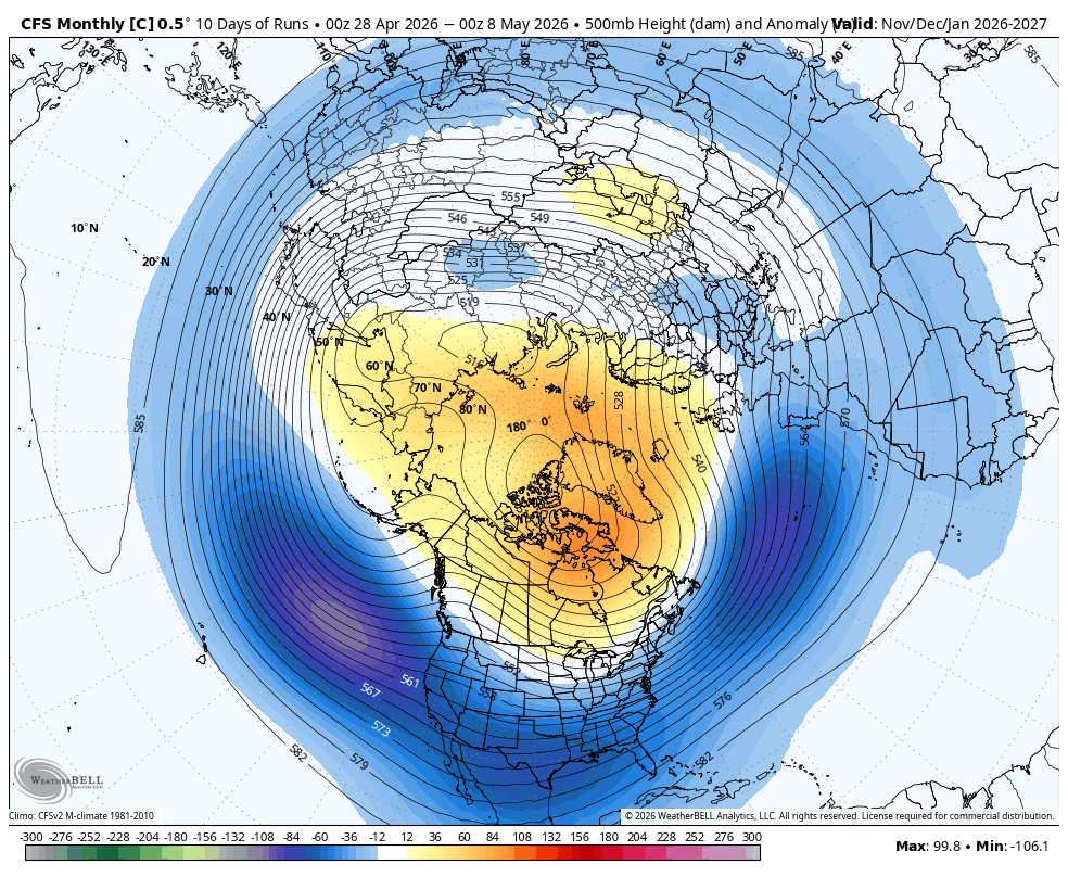
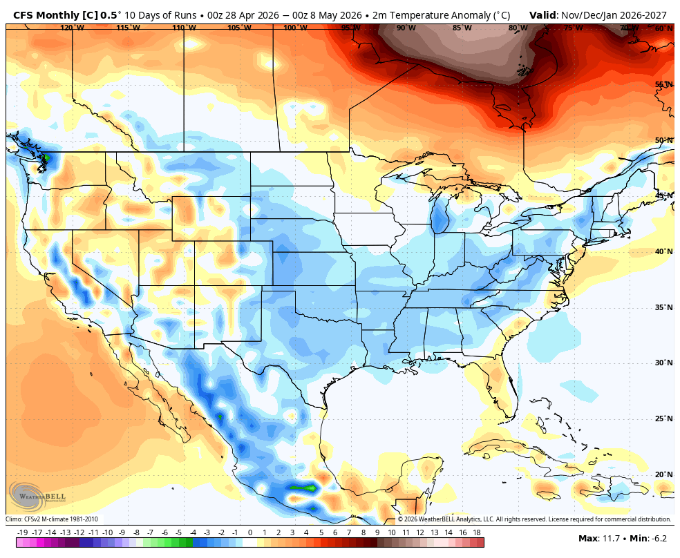
@BigJoeBastardi May be about right irt Temps if persistent blocking is realized. However, if the Nino is super strong that may shunt the effects of blocking or just flood the Country with mildness. Cold Pool off SE Canada should enhance 50-50 Low likelihood.
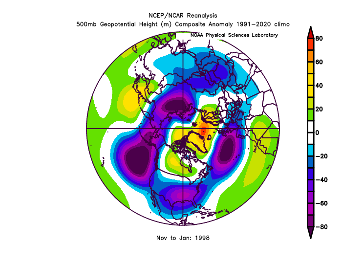
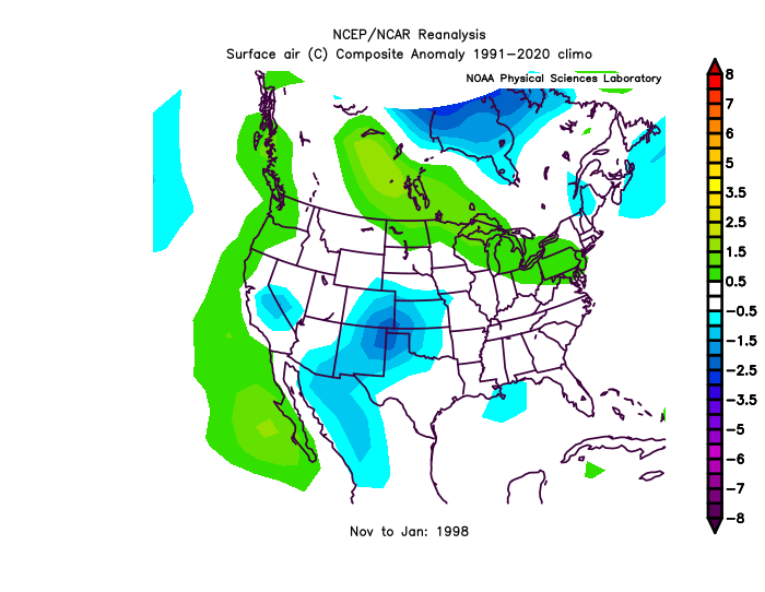
Last 10 days of CFSV2 for NDJ look alot like the strongest super Nino on record at 500 mb ( 97-98)
CfSV2 Tho has a colder temp look, which is questionable given its cold biast
El Niño is coming… and it could be a big one!
The Forecasted atmospheric response to the onset of El Niño looks very similar to what we saw in 1997-98.
There is a pretty subtle but significant difference between the 2026 forecast and 1997 though…
and that is the El Niño is being forecast to extend much further west into the Central Pacific than it did in 1997. If you look very closely you can see the green rising air is forecast to be much further west into the Pacific than it was in 1997.
If true, remember it still is just a forecast at this point, it would mean that the weather pattern we see in the US would not necessarily be the same weather pattern we saw in 1997-98.
So before you get carried away with “Winter is Over” talk here in May… just remember the positioning of these large scale atmospheric circulation cells (called Walker Cells) is very important with regard to precipitation patterns. If you’re in the part of the circulation cell that enhances upward motion, you’ll see more rainfall, however if you’re in a part of the circulation cell that enhances sinking motion, you’ll see less rainfall.
For example, during a typical El Niño pattern the sinking portion of a Walker cell is usually positioned over the Tropical Atlantic Ocean which tends to inhibit hurricane development.
~Meteorologist Mark Margavage
#wxtwitter#wxX#Tropicalwx
@BowTiedSkiBum@BigJoeBastardi El nino will weaking by winter and just because of possible real strong el nino that don't cancel winter no el nino is alike
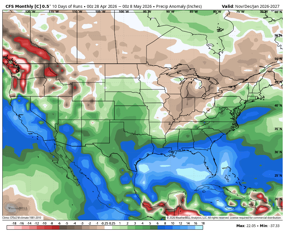
Good News. CFSV2 looks good for winter. Bad News: its the CFSV2
SST keeps it cold around Australia favoring more favorable MJO unlike 23-24 and has a positive PDO look ( of course did the same thing last time until the underwater volcanoes went off)
500 mb plenty of blocking, negative NAO. temps and precip pretty good
@AdamFurey4@WXNJsn0wf4nn@weather_buffalo Adam furry laughing because I said the el nino will fall off get weaker yet he said months back there winter be a el nino
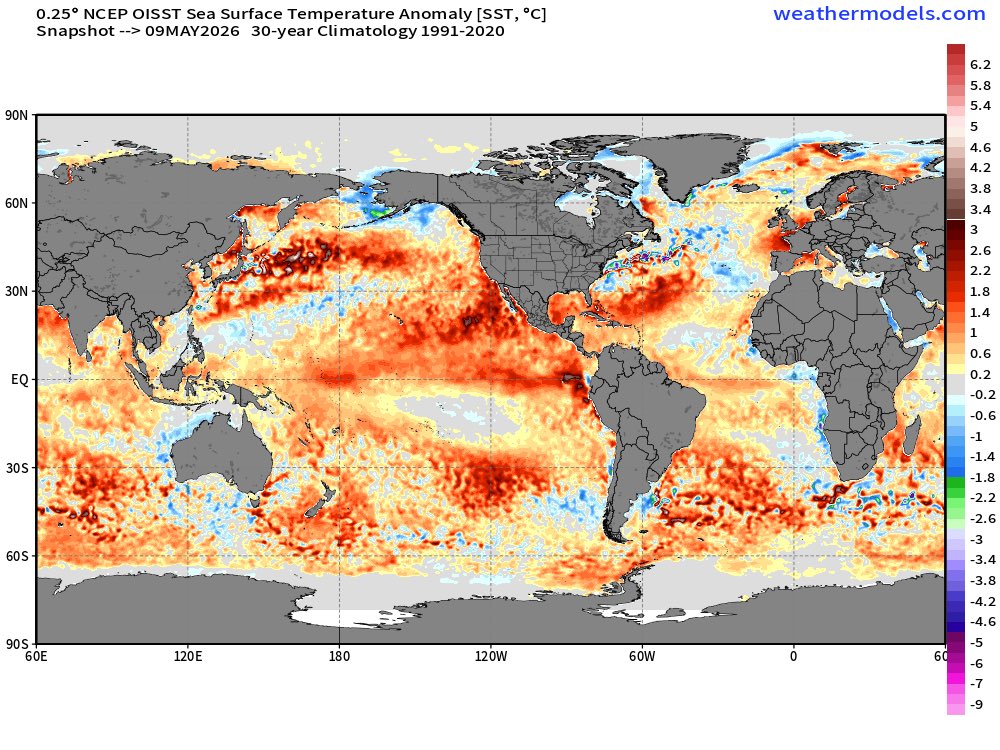
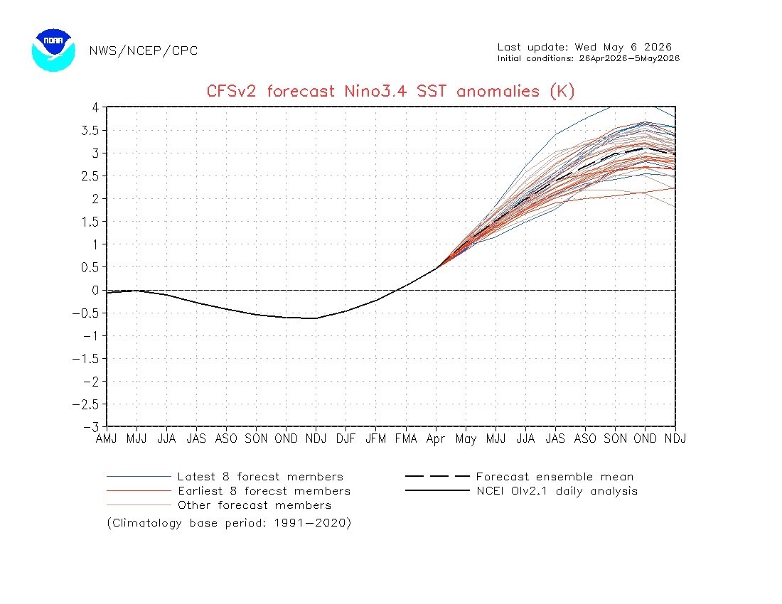
The CFS ensemble run is now predicting the Nino this year to hit 3.0 SST. The highest in recorded history was 2.3 back in 97-98 and 15-16. If this were to come to fruition, it would be the most powerful El Nino in recorded history, and it wouldn't even be close.
1997–1998 +2.3°
2015–2016 +2.3°
1982–1983 +2.2°
1972–1973 +2.1°
2023–2024 +2.0°
@MeteoMark Bunch of shit bags posting bad models. That means very little in the grand scheme of things. The atmosphere has to agree .its not likely to happen
New ECMWF data shows near a 100 percent chance of a super El Niño by October.
The central equatorial Pacific is forecast to surge 2.7˚C above average by then — approaching record levels — and this major climate event will still be intensifying 🧵