The Hokkaido Cartographer

607 posts

The Hokkaido Cartographer banner
The Hokkaido Cartographer

The Hokkaido Cartographer

@JapanMapping

Cartography is the love for art and geometry. My mission is to make Swiss 🇨🇭 cartography known in Japan 🇯🇵 and to create new map series for Japan.

Katılım Şubat 2022
177 Takip Edilen289 Takipçiler
Sabitlenmiş Tweet
The Hokkaido Cartographer
The Hokkaido Cartographer@JapanMapping·
Still available from my Japanese distributor @alice_sha, the award-winning, first bilingual hiking map for Japan in Swiss map style of #Hokkaido's tallest mountain, "ASAHI-DAKE: The Heart of Daisetsuzan National Park". alicesha.co.jp/books/0115/ind…
Markus Hauser@hausibek

In honour of the host country of #icc2019tokyo, the cover of the "Swiss National Report - Cartography in Switzerland 2015-2019" features a Swiss-Japanese co-production: the map "Asahi-dake - The heart of the Daisetsuzan National Park" 1:25,000 @ICC2019TOKYO @asahidake_2291
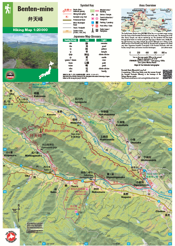
English
0
0
4
0
The Hokkaido Cartographer retweetledi
The Japan Times
The Japan Times@japantimes·
Japan has removed the red-crowned crane, also known as the Japanese crane and designated by the government as a special natural monument, from its list of threatened species thanks to a population recovery. 👉 ebx.sh/21Vz8h
The Japan Times tweet media
English
2
55
222
4.4K
Gentleman in Japan
Gentleman in Japan@GaryLuscombe1·
A short stroll in fine, if crisp weather yesterday. I keep meaning to climb this mountain, it looks like the kind of peak that might have once had something interesting at the top.
Gentleman in Japan tweet media
English
1
0
15
331
糸魚川ユネスコ世界ジオパーク Itoigawa UNESCO Global Geopark
📢日本初!糸魚川でラピスラズリ発見💎 国立科学博物館の研究で、国内初の「瑠璃の宝石」が糸魚川で見つかりました!エジプトや正倉院の宝物と同じ神秘の青が、ついに日本でも…💙 実物はフォッサマグナミュージアムで期間限定、無料展示します! 詳しくは👉 geo-itoigawa.com/topics/25735/
糸魚川ユネスコ世界ジオパーク Itoigawa UNESCO Global Geopark tweet media
日本語
18
1.6K
4.5K
167.3K
Beatrix Holland
Beatrix Holland@hellobeatrix·
Popped into the fancy fancy supermarket and was set upon a little dinner mission. I stuffed these zucchini flow with goat’s cheese and dill, did a light beer batter and served them with Al Brown’s preserved lemon mayo.
Beatrix Holland tweet mediaBeatrix Holland tweet mediaBeatrix Holland tweet mediaBeatrix Holland tweet media
English
9
5
69
1.8K
The Hokkaido Cartographer retweetledi
Gentleman in Japan
Gentleman in Japan@GaryLuscombe1·
The 500 year old plum tree in the garden at work is finally starting to wake up. Takes a little while to get going compared to the younger trees. A feeling I know too well.
Gentleman in Japan tweet media
English
1
3
51
808
The Hokkaido Cartographer
The Hokkaido Cartographer@JapanMapping·
@japantimes_life I invite you to visit my website japanwilds.org, which features links to over 1,000 English-language hiking blogs (incl. hers) and over 100 bilingual hiking maps in Swiss quality covering all of Japan. Special attention is given to lesser-known areas.
English
0
0
0
22
Japan Times: Life
Japan Times: Life@japantimes_life·
Hiking Mount Fuji is one thing, but English-language guides on Japan’s lesser-known peaks and trails can be scarce. But on the semianonymous Lost Filipina blog, hundreds of treks are mapped out to the smallest detail. ebx.sh/YiTwAO
English
1
4
4
392
The Hokkaido Cartographer
The Hokkaido Cartographer@JapanMapping·
For a few days now, @yamareco (Cloudfare) has been requesting a security check, and then, when you're on the site, the photos are no longer displayed. Has anyone else experienced something similar? Is it because I'm accessing the site from abroad? (I'm Premium member)
The Hokkaido Cartographer tweet media
English
0
0
1
303
The Hokkaido Cartographer retweetledi
David Lowe
David Lowe@Ridgelineimages·
Lake Okutama is retreating 📉🌊 In my latest post, I compare photos from 2016 with today revealing re-emerging tree skeletons, exposed infrastructure, and Showa-era relics. ridgelineimages.com/musings/the-re… #奥多摩湖 #小河内ダム
David Lowe tweet mediaDavid Lowe tweet mediaDavid Lowe tweet mediaDavid Lowe tweet media
English
0
1
4
293
The Hokkaido Cartographer retweetledi
The Japan Times
The Japan Times@japantimes·
2.9 million people visited Hakuba in 2025. How much change can a mountain community of fewer than 10,000 people absorb before it stops feeling like home? ebx.sh/oBGF4W
English
0
3
5
2K
David Lowe
David Lowe@Ridgelineimages·
If you’ve been to Kawaguchiko lately, you know it’s "Ground Zero" for international tourism. But while the crowds are queuing for photos at Lawson, the best views are waiting just a short bus ride away on the ridge above Lake Saiko. ridgelineimages.com/hiking/mt-ashi…
David Lowe tweet mediaDavid Lowe tweet mediaDavid Lowe tweet mediaDavid Lowe tweet media
English
1
0
4
242
Tom Fay
Tom Fay@T_in_Japan·
@TimDHWoo I can well believe it - if I hadn’t had my gps I would probably have got lost too, severe whiteout conditions for much of the way. The ropeway wasn’t running when I climbed (because of the wind), so I actually had to start and finish from the base, was a long and hard day
English
1
0
0
14
Tom Fay
Tom Fay@T_in_Japan·
At the summit of Asahi-dake, Hokkaido’s highest peak, in mid-winter
Tom Fay tweet mediaTom Fay tweet media
English
2
0
7
335
The Hokkaido Cartographer retweetledi
Japan Geospatial Times
Japan Geospatial Times@jgtimes_org·
🌐 New article: Hinata GIS and open-hinata3 — Japan’s Ultra-General-Purpose Open-Source GIS in Practice Discover a highly versatile Web GIS built by a Japanese solo developer, featuring 600+ layers and AI-powered tools. Read more ➡️ jgtimes.org/articles/eh-hi… #GIS #foss4g
Japan Geospatial Times tweet media
English
1
2
9
4K
Gentleman in Japan
Gentleman in Japan@GaryLuscombe1·
Quiet at work so I wandered down to the other end of the village to take some photos of a shrine. On the way back I got distracted by a little old road that passes underneath the railway line. It seems to go all the way up into the mountains so will explore more another day.
Gentleman in Japan tweet mediaGentleman in Japan tweet mediaGentleman in Japan tweet mediaGentleman in Japan tweet media
English
2
2
39
943
The Hokkaido Cartographer
The Hokkaido Cartographer@JapanMapping·
@GaryLuscombe1 A lovely welcome when walking up to Koysan from below, from Gokurakubashi Station. I would recommend this to anyone who is reasonably fit, rather than taking the cable car and then the bus.
English
0
0
1
38
Gentleman in Japan
Gentleman in Japan@GaryLuscombe1·
The last surviving Nyonindo, or Women's Hall on Koyasan. Originally there were seven such halls, one just outside each of the main entrances as women were prohibited from entering Koyasan. It was established by a nun called Kosugi who was enshrined as Kosugimyojin on her death.
Gentleman in Japan tweet media
English
1
3
36
1.1K
秋野
秋野@AreChauchauchau·
There are worse ways to spend a groomer day. Inawashiro definitely deserves a second visit with more snowfall. Did I mention the 3300 yen lift passes? 🤫
秋野 tweet media秋野 tweet media秋野 tweet media秋野 tweet media
English
1
0
6
163
The Hokkaido Cartographer retweetledi
在日スイス大使館
在日スイス大使館@SwissEmbassyJP·
🇨🇭🇯🇵 スイス文化イベント in 日本 – 2026年冬 ❄️🎬🎨📖🎶 この冬、日本各地でスイスゆかりの文化イベントが開催されます。 話題の映画、美術、トーク、音楽──多彩な表現を通し、スイスの創造性に触れてみてください✨ 👉loom.ly/O64zN9Q #スイス #スイス文化 #映画 #音楽 #トーク #国際交流
在日スイス大使館 tweet media
日本語
0
21
152
5K
The Hokkaido Cartographer retweetledi
在日スイス大使館
在日スイス大使館@SwissEmbassyJP·
🗺️✨ JAPANWILDS はスイス人地図制作者マルクス・ハウザーによる日本の登山地図&ハイキングガイド🇨🇭🇯🇵 スイスの精緻な地図製作技術と日本の自然美を融合。北海道旭岳や東京奥多摩をはじめとする英日二言語マップは、正確で地形を直感的に読み取れます。Atlas of Design にも掲載の、機能美あふれる一枚です⛰️ @JapanMapping #スイス #日本 #ハイキング #地図 #登山
在日スイス大使館 tweet media在日スイス大使館 tweet media在日スイス大使館 tweet media在日スイス大使館 tweet media
日本語
1
8
31
2.3K