Jed Castles News 9

36.1K posts

Jed Castles News 9 banner
Jed Castles News 9

Jed Castles News 9

@JedCastles

Certified Broadcast Meteorologist. News 9 Meteorologist in OKC. Christ follower..4th Gen Oklahoman #SOONERS IG/TikTok: jedcastles Jude 1:2 @news9

Oklahoma City, OK Katılım Şubat 2009
4.3K Takip Edilen21.3K Takipçiler
Jed Castles News 9
Jed Castles News 9@JedCastles·
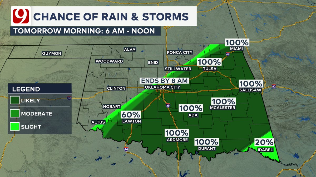
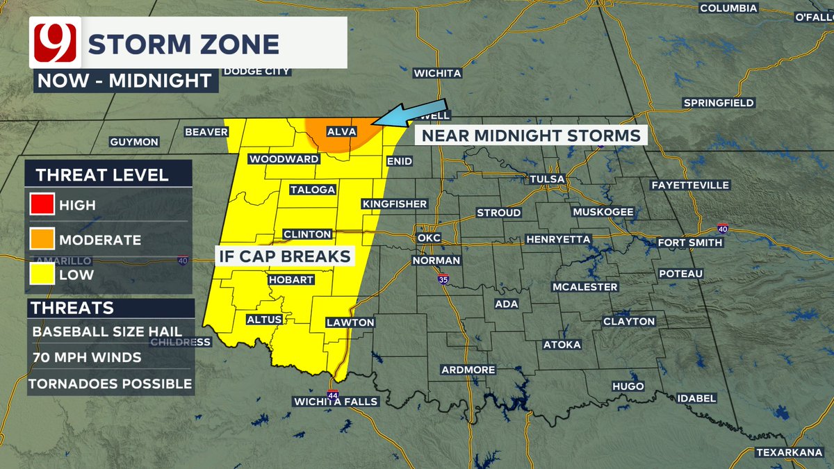
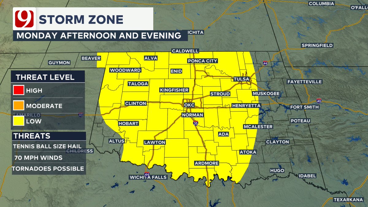
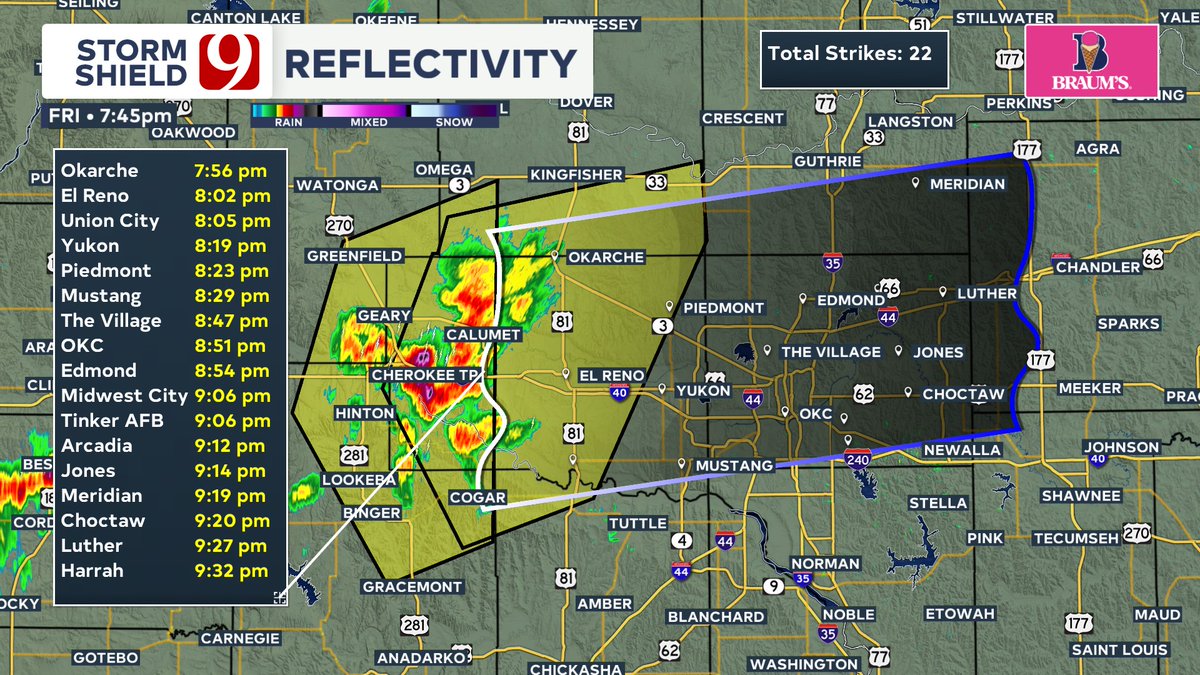
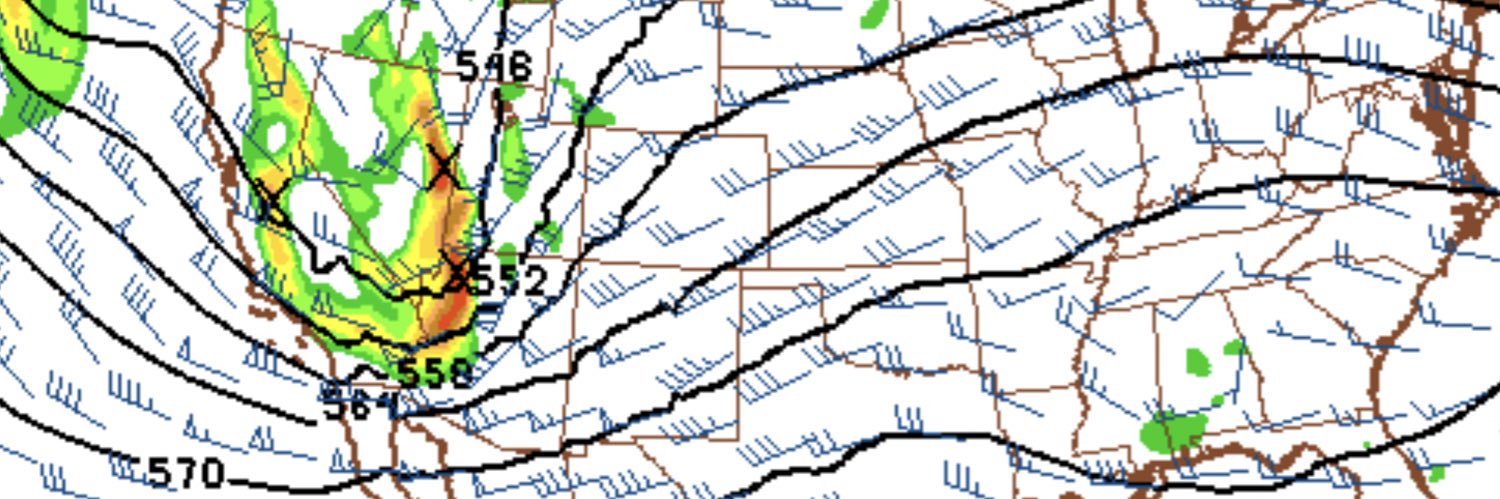
CAP WINS! Storms continue to weaken with a couple of downpours & gusty winds left. Trackers are out, and we'll be watching, but the main focus will shift to the cold front & line of storms north. These will move south overnight with the threat of gusty winds & hail. #okwx
Jed Castles News 9 tweet mediaJed Castles News 9 tweet mediaJed Castles News 9 tweet mediaJed Castles News 9 tweet media
English
0
0
3
387
Jed Castles News 9
Jed Castles News 9@JedCastles·
5:06 PM RADAR UPDATE: Scattered storms have formed form near Clinton to Granite to near Duke. Quarter sized hail reported near Duke. The north storm warning will be canceled. Wind and hail are the primary threats.
Jed Castles News 9 tweet mediaJed Castles News 9 tweet media
English
0
0
0
195
Jed Castles News 9
Jed Castles News 9@JedCastles·
STORMY TONIGHT, MUCH COOLER TUESDAY: Storms will be moving across the state tonight and shoving into SE OK Tuesday morning. Air will turn cooler behind the front with daytime highs struggling thru the 60s.
Jed Castles News 9 tweet mediaJed Castles News 9 tweet mediaJed Castles News 9 tweet mediaJed Castles News 9 tweet media
English
0
0
0
170
Jed Castles News 9
Jed Castles News 9@JedCastles·
TORNADO WATCH UNTIL 12 AM: A tornado watch is in effect for the west OK west of a line from Cherokee to Lawton. Tornadoes, tennis ball size hail and gusts to 70 mph are possible.
Jed Castles News 9 tweet media
English
0
0
1
252
Jed Castles News 9
Jed Castles News 9@JedCastles·
THIS EVENING: Storms in west OK will have a tornado, wind and hail threat. These will stay west of OKC thru 11 pm. More storms are expected to develop overnight a a cold front moves thru. OKC can expect storms after Midnight.
Jed Castles News 9 tweet mediaJed Castles News 9 tweet mediaJed Castles News 9 tweet mediaJed Castles News 9 tweet media
English
0
1
1
250
Jed Castles News 9 retweetledi
Andrew Adams
Andrew Adams@AAdamsWX·
Rain and storm chances return Monday, but we might be talking about the cap once again limiting the number of storms... so through tomorrow evening, low chances for storms. If they form, severe threats possible. Cold front tomorrow night brings better chances for rain. #okwx
Andrew Adams tweet mediaAndrew Adams tweet mediaAndrew Adams tweet mediaAndrew Adams tweet media
English
2
9
41
4.2K
Jed Castles News 9 retweetledi
Andrew Adams
Andrew Adams@AAdamsWX·
Officially slamming the door shut on our Sunday severe weather chances in Oklahoma. Dryline is retreating west. Some weak, high based showers occasionally developing in southern Oklahoma. Cap gets a resounding victory over thunderstorm development!
Andrew Adams tweet media
English
3
7
61
3.2K
Jed Castles News 9 retweetledi
Andrew Adams
Andrew Adams@AAdamsWX·
Radar Update 5:48 PM - Some small showers have developed along the dryline in the Eastern Texas Panhandle into Northwest Oklahoma. No lightning, but something we will be watching over the next couple of hours. Storm initiation struggling against the Cap right now. #okwx
English
0
6
25
4.8K
Jed Castles News 9 retweetledi
Andrew Adams
Andrew Adams@AAdamsWX·
We are watching two areas for thunderstorm development through this evening. One is out west along the dryline. The other is form North Texas into Central Oklahoma. If the cap weakens enough for storms, severe thunderstorms will be possible. #okwx
Andrew Adams tweet mediaAndrew Adams tweet mediaAndrew Adams tweet media
English
0
10
40
5.9K
Jed Castles News 9
Jed Castles News 9@JedCastles·
SUNDAY FORECAST: Another very windy and very warm to hot day expected. A few storms are possible late day. Some could be severe with wind and hail the primary threats. Tornado threat is low..
Jed Castles News 9 tweet mediaJed Castles News 9 tweet mediaJed Castles News 9 tweet mediaJed Castles News 9 tweet media
English
0
1
0
302
Jed Castles News 9 retweetledi
Andrew Adams
Andrew Adams@AAdamsWX·
We are watching a field of cumulus clouds bubbling up in the Panhandles that may bring in a couple storms to Western Oklahoma this evening with a wind and hail threat. The chance for isolated severe storms returns for Sunday. #okwx
Andrew Adams tweet mediaAndrew Adams tweet mediaAndrew Adams tweet mediaAndrew Adams tweet media
English
0
8
23
3.3K
Jed Castles News 9 retweetledi
Andrew Adams
Andrew Adams@AAdamsWX·
Severe Thunderstorm Warning for Caddo, Canadian, Kingfisher, and Grady counties until 8:30 PM. 60 mph gusts and quarter size hail possible. #okwx
Andrew Adams tweet media
English
1
7
13
2.2K
Jed Castles News 9 retweetledi
Andrew Adams
Andrew Adams@AAdamsWX·
Radar Update 7:25 PM - Broken line of severe thunderstorms extends from Canadian county west along I-40 and then south into Texas. These storms have been capable of producing 60-75 mph gusts. Wind gust threat will continue for the next couple of hours as they move east. #okwx
English
0
5
18
4.7K
Jed Castles News 9 retweetledi
Andrew Adams
Andrew Adams@AAdamsWX·
Serious heat in western Oklahoma today! Air west of the dryline got hot enough to jump well into the triple digits, taking down several records. #okwx
Andrew Adams tweet media
English
2
5
14
2K
Jed Castles News 9
Jed Castles News 9@JedCastles·
Sunday, the heat continues with a sharpening dry line that could develop a couple of severe storms in NW OK. Highs remain in the 80s to 100s west. Storm chances increase on Monday and persist into Monday night, with severe weather likely along the cold front from Monday evening i
Jed Castles News 9 tweet mediaJed Castles News 9 tweet mediaJed Castles News 9 tweet mediaJed Castles News 9 tweet media
English
0
1
0
240
Jed Castles News 9
Jed Castles News 9@JedCastles·
Watching the threat of storms this evening across mainly SW OK. A few storms could be marginally severe with some damaging winds. Warm overnight with lows in the 70s. Tomorrow we continue with the heat & wind with a low chance of storms, 20%, out west. #okwx
Jed Castles News 9 tweet mediaJed Castles News 9 tweet mediaJed Castles News 9 tweet mediaJed Castles News 9 tweet media
English
0
0
0
237
Jed Castles News 9 retweetledi
Andrew Adams
Andrew Adams@AAdamsWX·
A Severe Thunderstorm Watch has been issued for the Panhandle and far-western Oklahoma until 10 PM. #okwx
Andrew Adams tweet media
English
0
4
14
1.9K
Jed Castles News 9 retweetledi
Andrew Adams
Andrew Adams@AAdamsWX·
Rain chances remain mainly isolated through Saturday and Sunday. Storms that are able to form this weekend may be capable of some wind and hail. Greater chances for rain and storms arrive late Monday. #okwx
Andrew Adams tweet mediaAndrew Adams tweet mediaAndrew Adams tweet media
English
0
5
17
2.2K
Jed Castles News 9 retweetledi
Andrew Adams
Andrew Adams@AAdamsWX·
Summer like heat continues through the next few afternoons. Some of Oklahoma will be close to records. Highs routinely sit in the 90s with a gusty south wind. #okwx
Andrew Adams tweet mediaAndrew Adams tweet mediaAndrew Adams tweet mediaAndrew Adams tweet media
English
0
5
15
1.7K