Lees Summit Police retweetledi
Lees Summit Police
2.3K posts

Lees Summit Police
@LSPDPIO
Public Information Unit -- Lee's Summit MO Police Department This account is not monitored 24 hours a day, if you have an emergency, call 911 or 816-969-7390 #7
Lee's Summit, MO Katılım Ağustos 2013
229 Takip Edilen5.8K Takipçiler
Lees Summit Police retweetledi
A complex of thunderstorms is expected to develop in eastern Nebraska and move southeast into the region tonight. Damaging winds and tornadoes will be possible, especially across northwestern Missouri. Storms are expected to weaken with time.

English
We stand in remembrance of those we’ve lost and in support of the families, friends, and fellow officers who carry their legacy forward each day.
Please take a moment today to reflect, remember, and show gratitude for those who gave everything to protect our communities.
English
Today, on Peace Officers Memorial Day, we pause to honor the brave men and women who made the ultimate sacrifice in the line of duty.
Their courage, commitment, and selfless service will never be forgotten.

English
Lees Summit Police retweetledi

JACKSON COUNTY – MoDOT will be conducting a single lane closure on Missouri Highway 291 southbound, just south of Persels Road for pavement work from approximately 7:00 PM on Thursday, May 14 until 6:00 AM on Friday, May 15. modot.org/node/88748

English
Lees Summit Police retweetledi
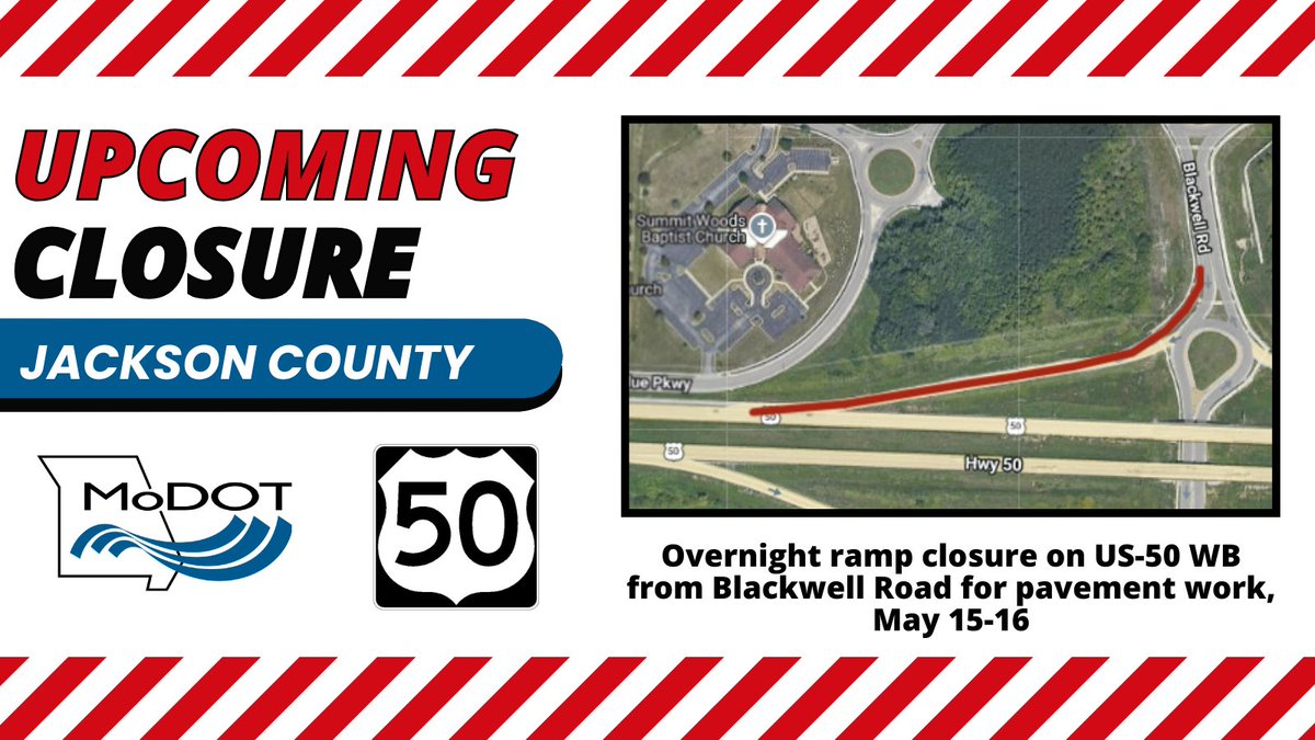
JACKSON COUNTY – The Missouri Department of Transportation will CLOSE the U.S. Route 50 westbound on ramp to Blackwell Road for pavement work from approximately 7:00 PM on Friday, May 15, until 6:00 AM on Saturday, May 16. All work is weather permitting. modot.org/node/88753
English
Lees Summit Police retweetledi
(JACKSON COUNTY) New head-to-head traffic configuration on SB MO 291 in Lee's Summit for utility work, May 19-June 9. #KCTraffic Details: modot.org/node/88845

English
Lees Summit Police retweetledi
Lees Summit Police retweetledi
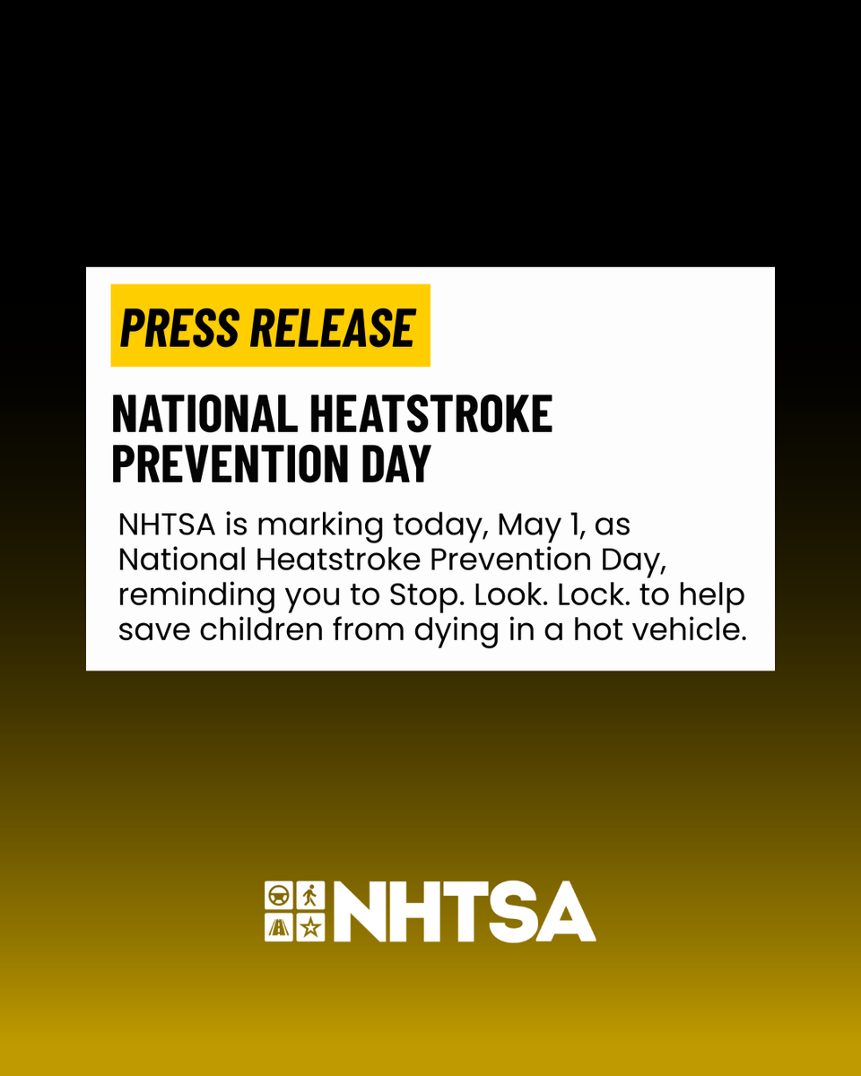
Two kids have already died this year after being left or forgotten in a hot car. ⚠️🌡️
This National Heatstroke Prevention Day, remind yourself that vehicles can heat up quickly — with temperatures rising 20 degrees in as little as 10 minutes — creating a deadly situation for a child left inside.
🔗 Prevention tips for parents and caregivers:
nhtsa.gov/press-releases…
nhtsagov@NHTSAgov
This National Heatstroke Prevention Day, remind yourself that it's NEVER safe to leave your child alone in a car — not even for a minute. 🥵🌡️ Once You Park, Stop. 🛑 Look. 👁️ Lock. 🔒 More: NHTSA.gov/Heatstroke
English
Lees Summit Police retweetledi

Lees Summit Police retweetledi

@SosOssian @ADT Have you called our non-emergency #? 816.969.7390, Option 7. We cannot dispatch officers from social media.
English

Lees Summit Police retweetledi

Lees Summit Police retweetledi

Lees Summit Police retweetledi

⌚⚡ Individual supercells are possible ahead of the dryline tomorrow between 4 PM and 7 PM across southeastern Nebraska and northeastern Kansas. Thunderstorms are expected to grow upscale into a line or clusters and move eastward into eastern Kansas and northwestern Missouri between 7 PM and midnight, arriving around 9 PM to 11 PM in the Kansas City metro. Storms will continue moving eastward across Highway 65 in northern and central Missouri after midnight through 2 AM Friday.
☄️🌪️💨 Thunderstorms that initially develop off the dryline and remain individual or discrete could produce very large hail, damaging wind gusts, and a tornado or two.
💨🌪️ As storms grow upscale into a line or clusters after sunset, damaging wind will become the primary threat, with the potential for a brief tornado.
🖥️ Here’s the latest run of Futurescan showing the potential evolution of thunderstorms from late afternoon into Thursday night. It may not be 100% accurate, but I think it’s doing a good job of handling the location, timing, and evolution.
English
Lees Summit Police retweetledi

Lees Summit Police retweetledi
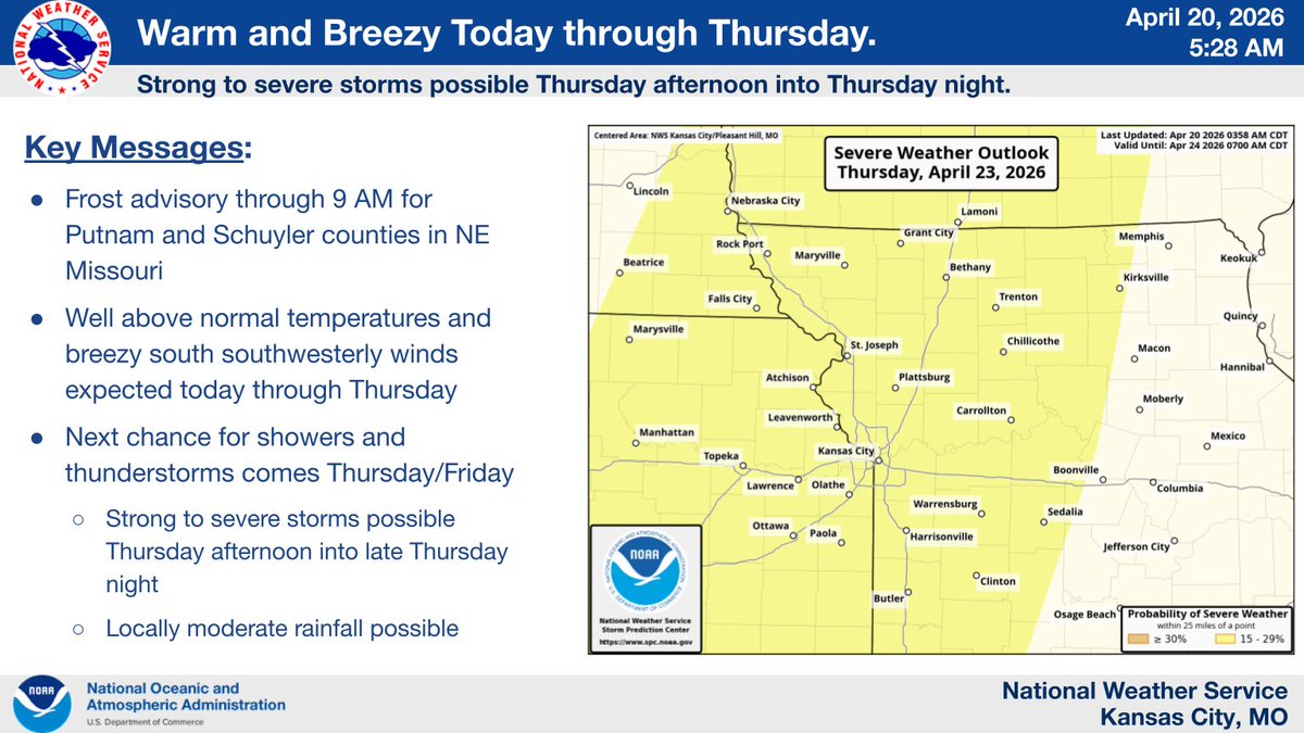
Sunny and warm today, with highs in the low to mid 70s. Warm and breezy conditions are expected to continue through Thursday.
The next chance for showers and storms arrives Thursday into Friday. Strong to severe storms may be possible Thursday afternoon into Thursday night.
English
Lees Summit Police retweetledi
JACKSON – MoDOT will be conducting a lane closure on NB I-470, just before Strother Rd. in Jackson for concrete repair operations, evening/overnight beginning at 7:00 pm on Thurs., April 16 until 6:00 am on Sat., April 18. All work is weather permitting. modot.org/node/87127

English
Enjoy today's weather as tomorrow will be a little sketchy at times!
NWS Kansas City@NWSKansasCity
⛈️ Another round of storms on track for Friday ⚠️ Chances for severe weather are higher Friday than any of the previous events this week. ⏰ Likely similar timing as Wednesday's event, early/mid afternoon to evening. ‼️ Stay in tune with weather conditions Friday! #kswx #mowx
English
Lees Summit Police retweetledi
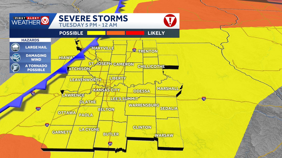
⚡ Y’all, we’re looking at a setup this afternoon and evening that’s very similar to what we saw Monday evening. There’s plenty of thunderstorm fuel, wind shear, and moisture, but once again, a strong cap is in place amid weak lifting across the dryline/cool front hybrid west of Kansas City. It’s unlikely thunderstorms will develop along that part of the front in eastern Kansas, but if storms do break the cap, they’ll be capable of producing all types of severe weather.
The more likely scenario is for thunderstorms to break the cap in Oklahoma and southeastern Kansas, then move northeast toward Kansas City late this afternoon and evening. With favorable ingredients for severe weather, the strongest thunderstorms will be capable of producing large hail, damaging winds, and a tornado. Remain alert between 5 PM and midnight, when severe weather is possible across most of the area.
There is another risk of severe thunderstorms Wednesday afternoon and evening, and again Friday afternoon and evening.
English