Tom Armitage

23.8K posts

Tom Armitage banner
Tom Armitage

Tom Armitage

@MapNav_Tom

Data Viz, Maps & GIS. Tech Writer for MapTiler. FOSS4G UK 2019 Co-Chair. Honorary Fellow of the University of Edinburgh GeoSciences. Views are all mine.

Crieff, Scotland Katılım Eylül 2011
804 Takip Edilen3K Takipçiler
Sabitlenmiş Tweet
Tom Armitage
Tom Armitage@MapNav_Tom·
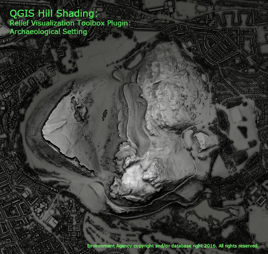
I did a comparison of the different hill shading tools in #QGIS and got some amazing results. Each one was blended with a DTM to give a bit of depth. Have a look at this thread for details on the 7 ways I tried, these are the most interesting. 1/n
Tom Armitage tweet media
English
5
51
205
0
Tom Armitage retweetledi
Julian Hoffmann Anton
Julian Hoffmann Anton@Julian_H0ffmann·
Who needs a scale bar when you can use a city? I put an Imperial I-class Star Destroyer (1,600m) from Rogue One and A New Hope over the City of London. Made in Blender.
Julian Hoffmann Anton tweet media
English
1
4
26
2.8K
Tom Armitage retweetledi
Kyle Walker
Kyle Walker@kyle_e_walker·
146 million US jobs. Visualized by sector on a fast, filterable interactive map. Fly from market to market smoothly with @MapTiler's geocoder. Explore for yourselves: walker-data.com/freestiler/lod…
English
3
13
89
9.7K
Tom Armitage retweetledi
MapTiler
MapTiler@MapTiler·
Create interactive buildings for #3D real-estate visualizations. Place, highlight, and interact with detailed models, floor by floor, building by building. Find out more about this and the rest of the latest news from MapTiler here: maptiler.link/49F9uKy
English
2
6
22
1.2K
Tom Armitage retweetledi
MapTiler
MapTiler@MapTiler·
Our lead cartographer @cartogenic drew on his experience living in Osaka to create the perfect map for #Japan. It uses both the official @gsi_cyberjapan data & our own Planet v4 dataset, giving familiar features in a clean, modern map style. Find out more: maptiler.link/4v1q2oE
MapTiler tweet mediaMapTiler tweet media
English
0
2
17
1K
Tom Armitage retweetledi
MapTiler
MapTiler@MapTiler·
Our new #map for #Japan is designed with symbols, naming conventions, and feature semantics that the locals are familiar with. It’s just one of the latest updates from MapTiler, which you can read about on our blog: maptiler.link/49F9uKy
MapTiler tweet mediaMapTiler tweet mediaMapTiler tweet media
English
1
3
38
3K
Tom Armitage retweetledi
Nick Bearman
Nick Bearman@NickBearmanUK·
New blog post! GISRUK 2026: GIS that makes a difference I was fortunate to be able to attend GISRUK 2026, at Uni of Birmingham. It’s great to see the latest GIS Research, catch-up with old colleagues &make new connections. Check out the whole blog at nickbearman.com/blog/2026-05-g…
Nick Bearman tweet media
English
0
2
9
473
Tom Armitage retweetledi
MapTiler
MapTiler@MapTiler·
MapTiler Server 4.8 released! Don’t forget tomorrow’s webinar about what's new in the latest version. Find out how you can blend your imagery into global datasets and more. It’s your last chance to register here: maptiler.link/496wQsD
MapTiler tweet mediaMapTiler tweet mediaMapTiler tweet media
English
0
3
34
2.1K
Tom Armitage retweetledi
MapTiler
MapTiler@MapTiler·
Our new Georeferencer eliminates the technical friction of manual file conversion for five major formats: PNG, JPEG, PDF, TIFF, and WebP. It allows you to define the location of your geodata effortlessly. Find out more: maptiler.link/41v8MLM #MapTiler #Geodata #WebMapping
MapTiler tweet media
English
0
8
63
3.6K
Tom Armitage retweetledi
MapTiler
MapTiler@MapTiler·
Check out the latest news from MapTiler: Interact with #3D Models on your maps, and a new Japanese map style! Read more: maptiler.link/4np4ob5
MapTiler tweet mediaMapTiler tweet media
English
0
2
15
888
Tom Armitage retweetledi
Kamil Onoszko 🇵🇱
Przygotowałem mapy z zasięgiem pożaru w Nadleśnictwo Józefów Szacunkowa powierzchnia wg. stanu na 06.05.2026 godz. 7:00 wynosi 480 ha. Opracowanie bazuje na danych pozyskanych z systemu NASA FIRMS. firms.modaps.eosdis.nasa.gov/map
Kamil Onoszko 🇵🇱 tweet mediaKamil Onoszko 🇵🇱 tweet mediaKamil Onoszko 🇵🇱 tweet media
Polski
4
31
132
19.4K
Tom Armitage retweetledi
MapTiler
MapTiler@MapTiler·
Want that atlas look and feel for your #webmaps? Need to show time zones on your location map? Check out our latest updates to find out more about our grid lines dataset and the latest updates to our satellite maps: maptiler.link/4e5af2y
MapTiler tweet mediaMapTiler tweet media
English
0
2
19
952
Tom Armitage retweetledi
MapTiler
MapTiler@MapTiler·
Need to publish your own data on top of global maps or imagery? MapTiler Server 4.8 will give you the power to blend your tilesets into our global maps with a new editor for virtual tilesets. Come to the Webinar on the 14th May, 17:00 CET to find out more: maptiler.link/496wQsD
English
0
5
32
2.1K
Tom Armitage retweetledi
Robin Hawkes
Robin Hawkes@robhawkes·
This is my grandad, he built the original R2-D2 for the first Star Wars film… Jack was a master sheet metal worker, and was roped into using his skills on an obscure project to turn the sketches for the droid into something that could be constructed out of aluminium sheets. I always knew he'd helped make part of R2-D2. However I only found this photo in recent years and have since learned that he was actually instrumental to the construction of the entire droid, particularly with working out how to machine the complex shapes like the dome and legs out of single sheets of aluminium. He didn't just build one either, he ended up constructing a handful of the droids for various uses in the film. I still have no idea how he did it, especially without modern software and computer-controlled machining. Unfortunately I never got to know him as he died when I was a baby, though I have a feeling we share a lot in common. I also have his old Dragon 32 computer that he was using to learn programming in the 1980s, with reams of hand-written code that still works on the computer. #MayThe4th #maythefouthbewithyou #StarWars
Robin Hawkes tweet media
English
174
1.1K
6.5K
127.8K
Tom Armitage retweetledi
MapTheClouds
MapTheClouds@maptheclouds·
Day 82. Lego City 🧱 Toy-system city experiment: MapLibre + custom Three.js/WebGL layer, GLSL colour logic, fly-to tower jumps, and orbit mode. Later evolved into In The Clouds with stacked 40m block logic. #100DayMapChallenge 82/100 #MapLibre #ThreeJS #GLSL
English
0
14
59
2.6K
Tom Armitage retweetledi
MapTiler
MapTiler@MapTiler·
🚀🌍 Do you love turning complex tech into clear, compelling stories? Are you excited by shaping how products are positioned, launched, and adopted in a global B2B SaaS environment? 👉 We’d love to hear from you: maptiler.link/4ueTbfk
MapTiler tweet media
English
0
3
3
359