When a spacecraft leaves Earth, it doesn’t just fire its engines and head straight to its destination.
In many missions, especially those going beyond low Earth orbit, there’s a more subtle and elegant strategy at play, one that uses gravity itself as part of the navigation system.
This is often called a gravity assist, or a slingshot maneuver. But in the case of missions like #Artemis II, what’s being used is a closely related idea known as a free-return trajectory.
At first glance, it might sound simple: the spacecraft goes to the Moon, loops around it, and comes back. But the physics behind it is anything but simple.
Instead of relying on continuous propulsion, the spacecraft follows a carefully calculated path through the gravitational field of the Earth–Moon system. It is launched with just the right speed and direction so that, as it approaches the Moon, the Moon’s gravity bends its trajectory. The spacecraft is effectively flung around the Moon, redirected onto a path that naturally brings it back toward Earth.
No major engine burn is needed for the return. Small trajectory corrections may still be required, but gravity does the heavy lifting.
That’s the key.
This kind of trajectory is not just efficient, it’s also safe. If something goes wrong with the spacecraft’s engines or onboard systems, gravity itself ensures the return.
It’s an inherent backup plan, built into the trajectory from the very beginning.
The same fundamental idea appears in gravity assists used across the Solar System. When a spacecraft flies past a planet, it can gain or lose speed by exchanging momentum with that planet. From the spacecraft’s point of view, it’s as if it has been accelerated without using fuel.
In reality, it has borrowed a tiny amount of orbital energy from the planet itself.
That’s how missions like Voyager reached the outer planets, and how probes continue to explore regions far beyond what their onboard fuel alone would allow.
But there’s an important distinction.
An interplanetary gravity assist is typically used to change speed and direction, often increasing the spacecraft’s energy. A free-return trajectory, like the one used in Artemis II, is designed for something more specific: a path that naturally loops back to Earth without requiring additional propulsion.
It’s less about gaining energy, and more about shaping a trajectory that guarantees a return.
To understand why this works, it helps to stop thinking in straight lines. In space, motion follows curves defined by gravity. The spacecraft is constantly falling, first toward Earth, then toward the Moon, and then back toward Earth again.
What looks like a loop is really a continuous free fall through a changing gravitational landscape.
This way of navigating space reveals something deeper. We tend to think of engines as the drivers of motion, but once a spacecraft is on its way, gravity does most of the work.
The art of spaceflight is not just about thrust.
It’s about knowing when not to use it.
#GoodLuck#Artemis@NASAArtemis
We're going around the Moon. Come watch with us. Artemis II's four-astronaut crew is lifting off from @NASAKennedy on an approximately 10-day mission that will bring us closer to living on the Moon and Mars. The launch window opens at 6:24pm ET (2224 UTC). twitter.com/i/broadcasts/1…
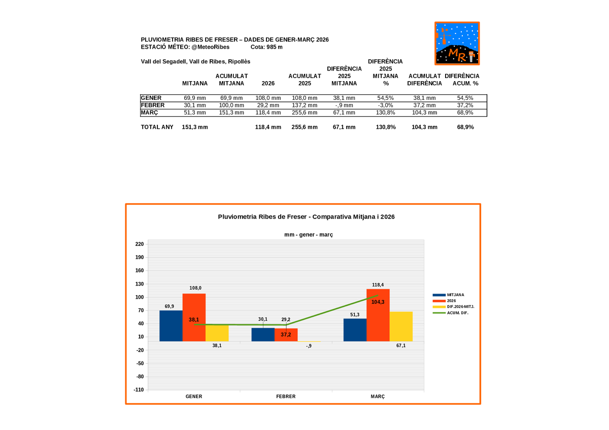
PLUVIOMETRIA DE RIBES DE FRESER - GENER-MARÇ 2026 - COTA 985 M, @MeteoRibes
Març 2026: 118,4 mm. Mitjana: 51,3 mm. +67,1 mm (+130,8%)
Any 2026 (gen.-mar.): 255,6 mm. Mitjana (gen.-mar.): 151,3 mm. +104,3 mm (+68,9%)
#ribesdefreser#valldelsegadell#vallderibes#ripollès
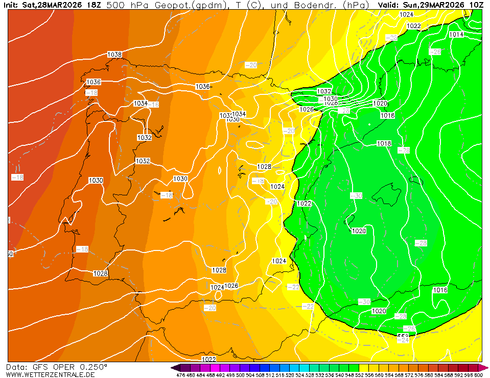
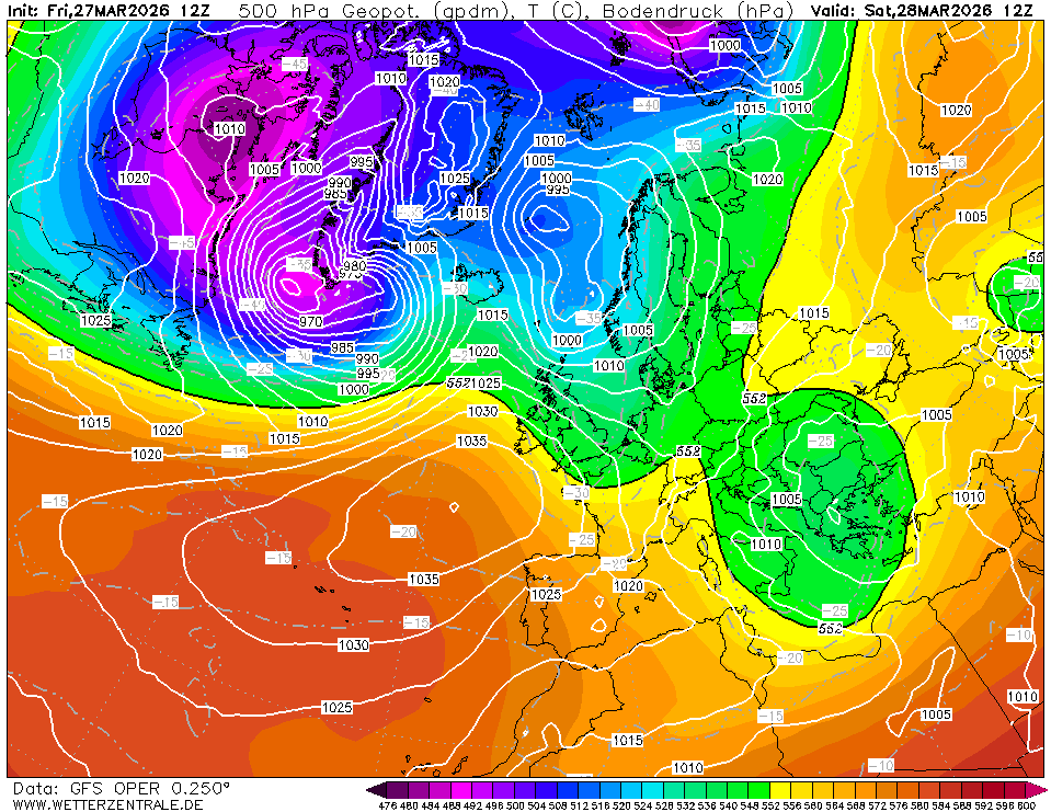
Com ja es veia ahir, aquesta nit potser tindrem TRAMUNTANA NEGRA! És a dir, plourà amb tramuntana. Un fenomen poc recurrent, però molt conegut: "Quan plou de tramuntana, plou de bona gana"! Aquí teniu el mapa d'humitat a 3.000m on s'aprecia com el riu humit s'escola per Girona!
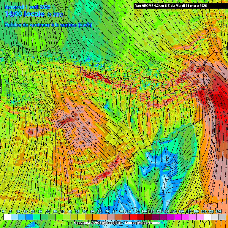
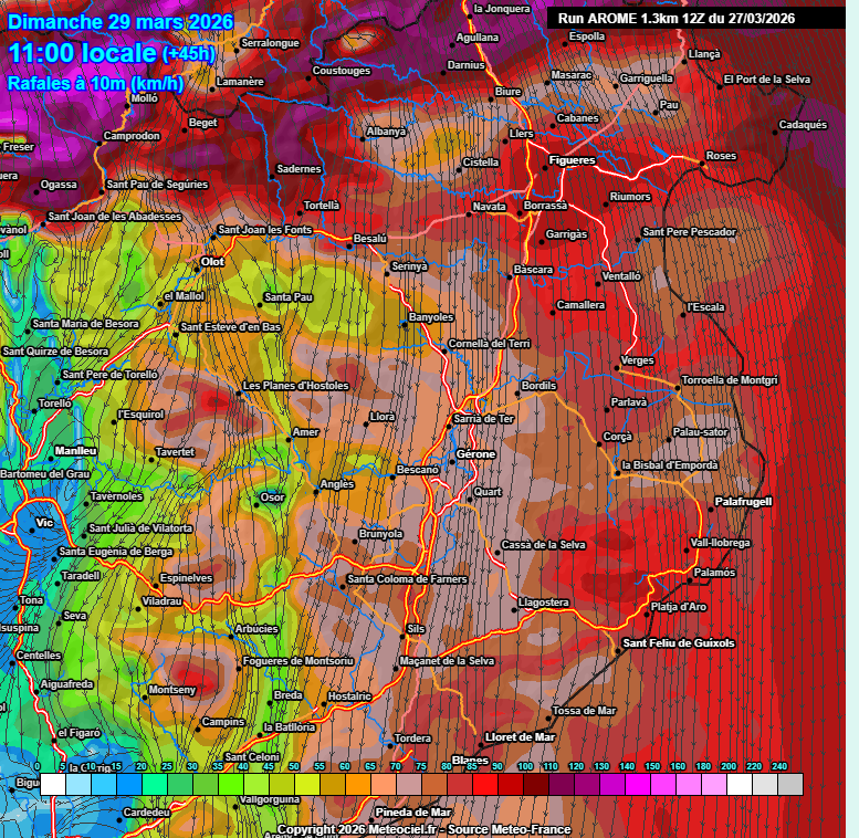
Després d'aquest ventós dimarts, dimecres encara seguirem amb VENT de NORD (NW/Mestral a l'Ebre) i una TRAMUNTANA que seguirà desbocada arribant amb intensitat (>60/70 km/h) fins a llocs poc habituals de l'interior de Girona, Cat.central, prelitoral de BCN i al pla de Lleida!💨👇
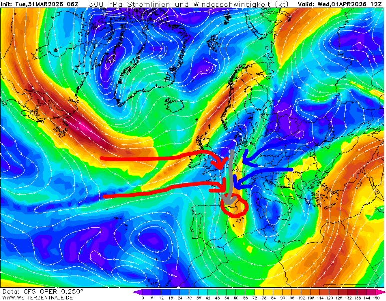
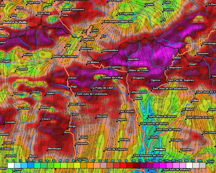
Aquest dimecres, la NOTÍCIA serà la NEVADA de NORD ESPECTACULAR que farà al N del Pirineu, on s'hi podran acumular +50CM >1.800m i +1 METRE >2.200m a 1 D'ABRIL! Situació de JET impactant contra el Pirineu de forma perpendicular i amb convergència atlàntica/continental, DE LLIBRE!
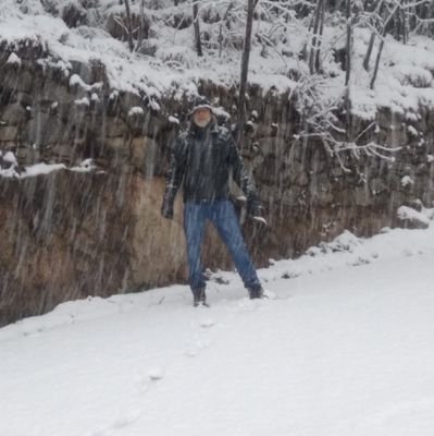
La pista de Setcases a -5°C a les 9 d'aquest matí. Després he parat i tornat endarrera per falta de cadenes i no liar-la parda, bé, blanca. No causem molesties.
@alexmegapc@Vakapiupiuu@jordicampos@alcantara_alb
El #Ripollès torna a a ser una de les comarques més afectades per les ventades aquest diumenge.
118 km/h a la cota 1140 m de Ribes de Freser
111 a Ulldeter 2.410 m
101 a Camprodon
100 a Gombrèn i a Molló
99 a Planoles
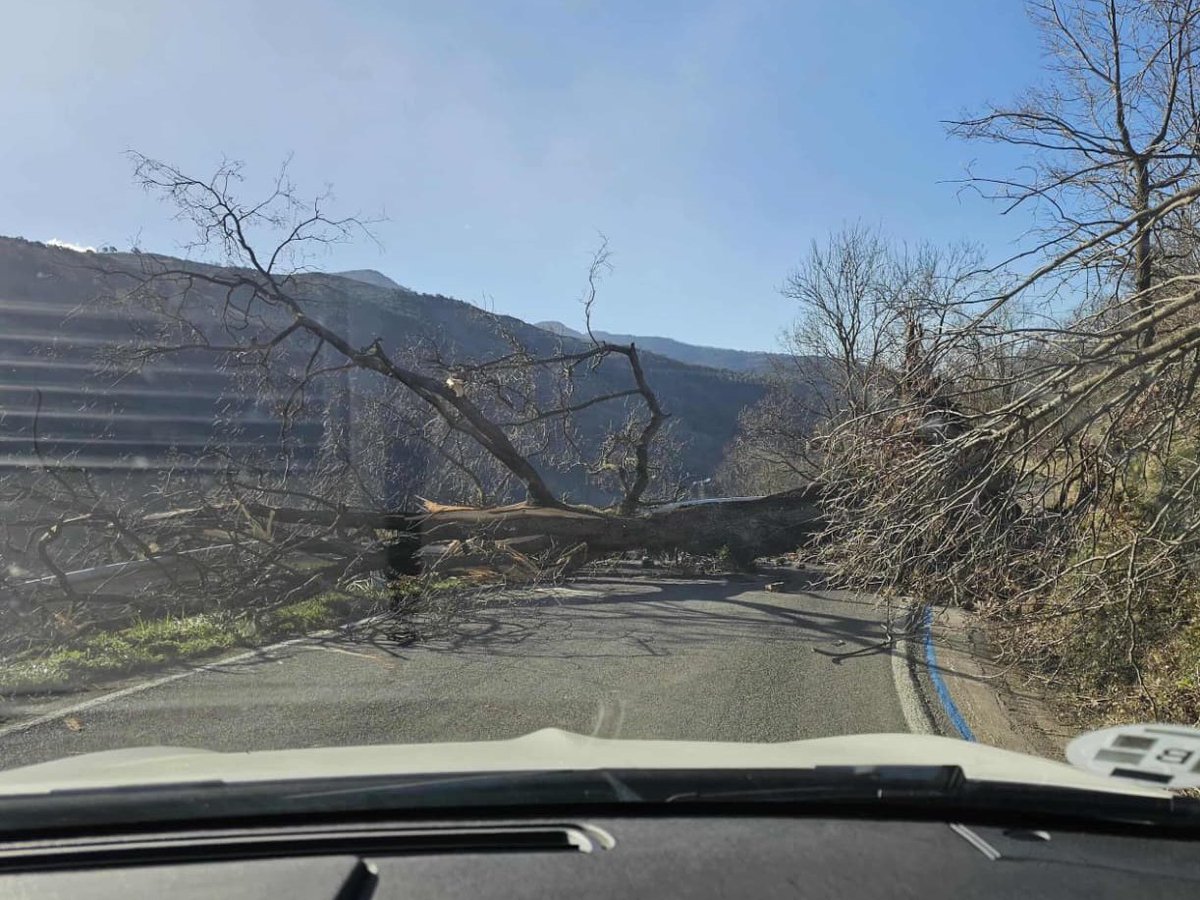
Un bon ensurt a la carretera de Campelles!! #ElTemps3Cat
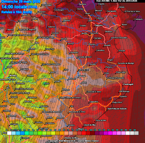
El jet ens passa en alçada al centre del dia, quan el vent del nord bufarà 💨amb més força. Ratxes d'avui:
📍 Portbou (Alt Empordà): 160,6 km/h
📍 La Tosa d'Alp, 2.478 m (Cerdanya): 113,0 km/h
📍 Ulldeter, 2.413 m (Ripollès): 110,5 km/h
📍 El Perelló (Baix Ebre): 109,8 km/h
El @meteocat incrementa segons un nou avís el perill de ventades fortes o molt fortes (en general superiors als 90 km/h) a tot el país, especialment al Ripollès, l'Alt Empordà, Garrotxa, Berguedà i Solsonès. No es descarten ratxes de més de 120 km/h. shorturl.at/m0Cp7
Els mapes de demà no es veuen sovint. És una TRAMUNTANADA inusual pel que fa a extensió! Per demà al matí donen 1016hPa al litoral nord i 1032hPa a l'Aran: GRADIENT BÀRIC DESCOMUNAL! Per cert, s'han descuidat ESAlerts a La Selva/Gironès i Baix Empordà. Cap dubte que es liarà!🥲
DIUMENGE -> Dia del canvi radical pel que fa al VENT. Altre cop +120/150 km/h al Pirineu, tant als cims com a les valls. Es produiran ones de muntanya i efectes venturi i Fohn. Fora del Pirineu, MOLTA ATENCIÓ també Girona ciutat i plana Selva/Gironès, Baix Empordà +90 km/h!
DISSABTE -> Arribada del front fred i la nova NORTADA a la tarda, però al matí encara aguantarà amb SOL arreu i poc vent. A partir del migdia s'anirà tapant de nord a sud de CAT. A la tarda tornaran les nevades al vessant N del Pirineu >1.200m i alguns ruixats entre GRN i BCN!