
Mr. Hogg
1.9K posts
Mr. Hogg
@MrHoggsClass
Math Teacher & Curriculum Leader | Spiraling through the curriculum | #funnyhogg #MtBos #vnps #thinkingclassroom
Ontario Katılım Mart 2014
275 Takip Edilen627 Takipçiler

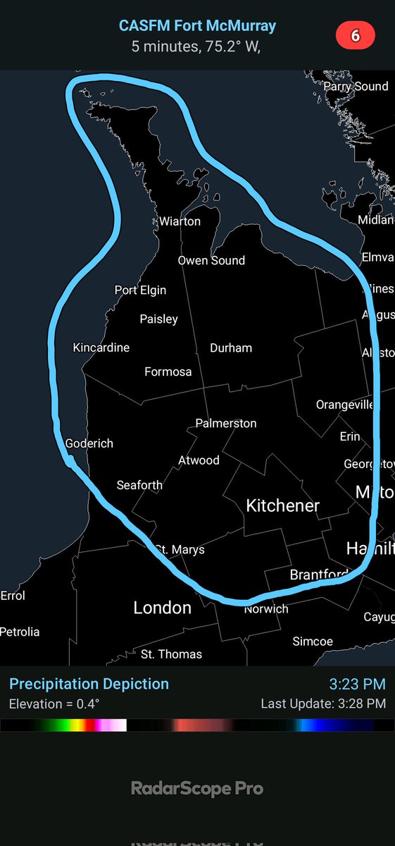
Widespread bus cancelations likely tomorrow across Southern #Ontario
Greatest chance would be across areas East of Lake #Huron where the Orange Freezing Rain Warning is in effect and areas outside of #Toronto and #Peel South where those area are always toss ups
Snowday #20 likely for those across the snowbelts 😅
#OnWX #ONStorm
English
@WxOntario1 Any chance of a slow down in the next 24 hours. Have to get some family from Toronto to Barrie?
English


Whiteout conditions east of Wasaga. Heed road closures PLEASE, we’ve seen 5-6 stuck cars every couple hundred yards. #onwx
English
@MrHoggsClass Did you go?
OPP GTA Traffic@OPP_GTATraffic
ROAD CLOSURE: #Hwy400 all northbound lanes are closed from Major Mackenzie to Lloydtown-Aurora Rd due to icy conditions and multiple collisions. The OPP is urging motorists to use caution while driving today and be prepared for unpredictable icy conditions. ^pia #AuroraOPP
English
Problems brewing Sun aft/PM for Kitchener-West/North GTA (N of 407 corridor) where significant freezing rain is increasingly likely. Have to watch how persistent that low level cold is but accretion could approach 15mm locally. More than enough for tree damage & power outages.

English
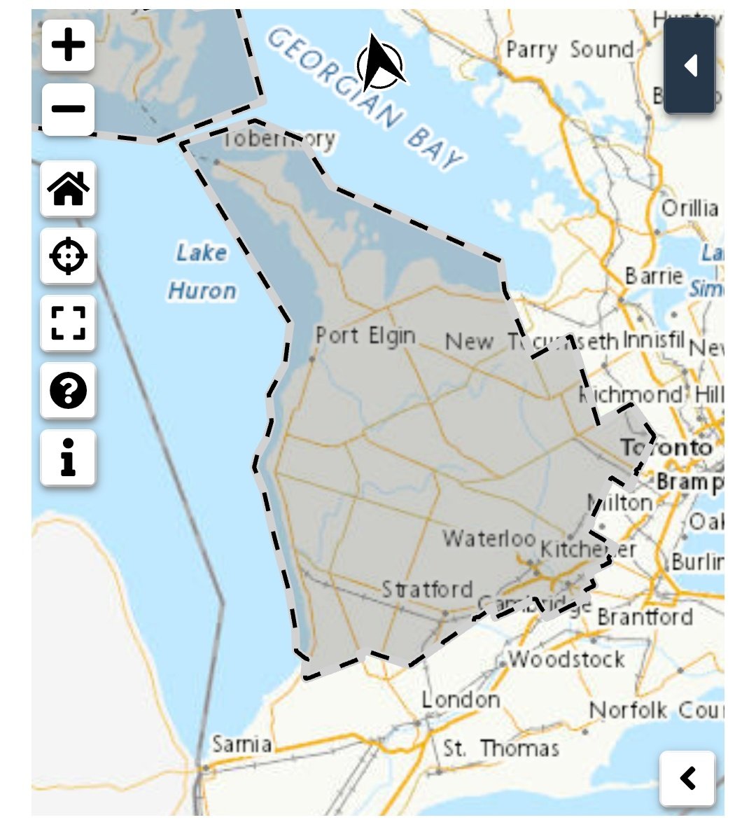
Based on the latest data rolling in, can definitely see the circled area (Higher Elevations of SW #Ontario) seeing more significant icing
Will have to monitor the temps through the afternoon to see if colder air lingers around longer
#OnWX #ONStorm

WxOntario@WxOntario1
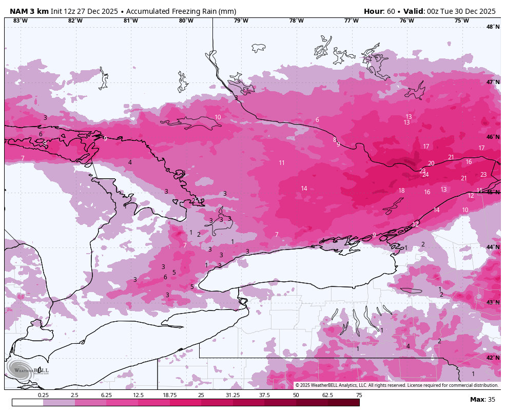
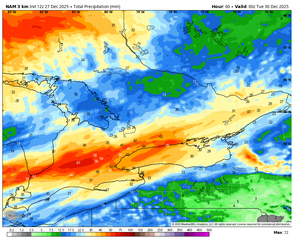
🧊🌧️Final forecast for the Storm Today into Tomorrow - Significant Freezing rain is likely across most of Central/ Eastern #Ontario - Zone 3 has the greatest chance at seeing the most ice accretion with up to 20mm (Locally 20+mm)- Widespread tree damage/ long duration power outages likely - The rest of Central/ Eastern Ont looks to see 5-15mm of FZR with most likely nearing the 15mm mark (Zone 2)- Tree damage and power outages possible/ likely - Higher elevations of SW Ont and into #Kitchener area also appear to stay colder longer leading to more significant icing - Elsewhere, a Trace to 5mm is possible - Significant rainfall is expected across parts of SW Ont and the #Hwy401 corridor through the #GTA- 30 to 50+mm - 15 to 30mm of rain is likely from Mid Western Ont into the North #GTA (Prolonged FZR may limit overall rainfall amounts - Winds will be gusting 30-50km/hr at times through the day and overnight (Strong/ damaging winds move in tomorrow AM) Will have a snowfall map out for the wrap around snow/ snow squalls out later today #OnWX #ONStorm
English
@MrHoggsClass Potentially significant freezing rain especially N of King City toward Barrie much of the afternoon. Could be a rough go on the 400.
English
@WxOntario1 Hoping to be back in Barrie before it hits tomorrow. Driving from Toronto to Barrie 3-4pm
English
Not much has changed on the latest data for the storm tomorrow into Sunday
Brief period of freezing rain across SW #Ontario/ #GTA then several hours of heavy rain
Preliminary thinking:
10-20mm of ice accretion across parts of Central/ Eastern Ont
30-50+mm of rain for the #GTA and parts of SW Ont/ #Niagara
Very strong winds don't move in until Monday mid morning
Will have a preliminary forecast out later today!
#OnWX #ONStorm
GIF
WxOntario@WxOntario1
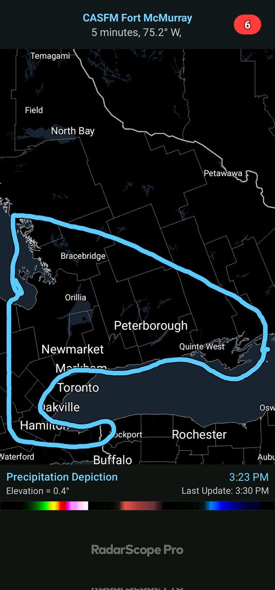
Update on the Sunday/ Monday Storm 👇 Looking to be a mostly rain event across SW #Ontario, #GTA and #Hwy401 corridor Could see 5-15mm of Ice Accretion across the higher elevations and Eastern Ont (Red Circled is new FZR from Sunday to Monday) As the storm pulls away Monday AM, rain changes to snow for the SW Squalls develop in the afternoon with 70+km/hr wind gusts Will watch and update! #OnWX #ONStorm
English
As expected, reports of ice pellets across the #GTA...
Warm upper air usually always wins in these setups
We'll have to see how long this lasts
Red circled area from this morning continues to look to see lower snowfall amounts
#OnWX #ONStorm


WxOntario@WxOntario1
Dry air has been winning out across the West #GTA while the east is doing well Most of Zone 5 should see the forecasted amounts of 8-15cm with local amounts of 15+cm possible Zone 4 remains a wild card with the dry air and risk of ice pellets #OnWX #ONStorm
English
@WxOntario1 Perfect. Thought I saw a mention of squalls in a previous report.
English
Update on the Boxing Day Storm Potential 👇
🇺🇸, 🇨🇦 and 🇪🇺 models below
All have a different outcome
Small shifts in track will have big impacts- all snow or icy mix
Hopefully mesocale models start nailing down the track tomorrow
Will update!
#OnWX #ONStorm
GIF
GIF
GIF
WxOntario@WxOntario1
Confidence is increasing on a high impact storm moving through Southern #Ontario on Boxing Day Models are split between mostly snow to freezing rain/ icy mix/ snow for a large chunk of the region Will watch the models/ data and have frequent updates this week #OnWX #ONStorm
English
@WxOntario1 Seems the models this year have done a poor job with most squalls off Georgian Bay
English
So far, the #GeorgianBay squall has been a dud other than hammering the #Angus/ #Wasaga area...
Heaviest snow has stayed west/ NW of #Barrie for the most part
Not as widespread/ long as the HRRR was forecasting
Had my doubts with this squall as similar things have happened before
#OnWX #ONStorm
GIF
WxOntario@WxOntario1
126cm of snow through Friday Afternoon, SW of #Barrie... #OnWX #ONStorm
English
@WxOntario1 What time are we thinking travel gets bad in Simcoe County?
English


@WxOntario1 The squall off Georgian Bay never really got organized.
English
@WxOntario1 @karenhegmann Any warm ups in September? Looks to remain cooler…
English
@karenhegmann Time for fall temps, Karen...
You've had plenty of 30C temps this summer
English
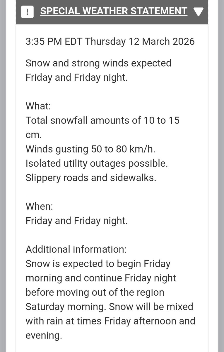
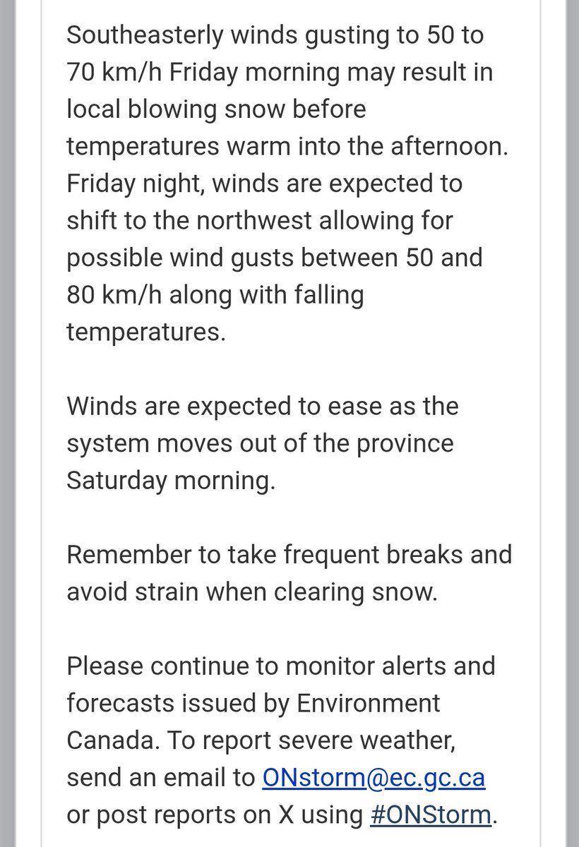
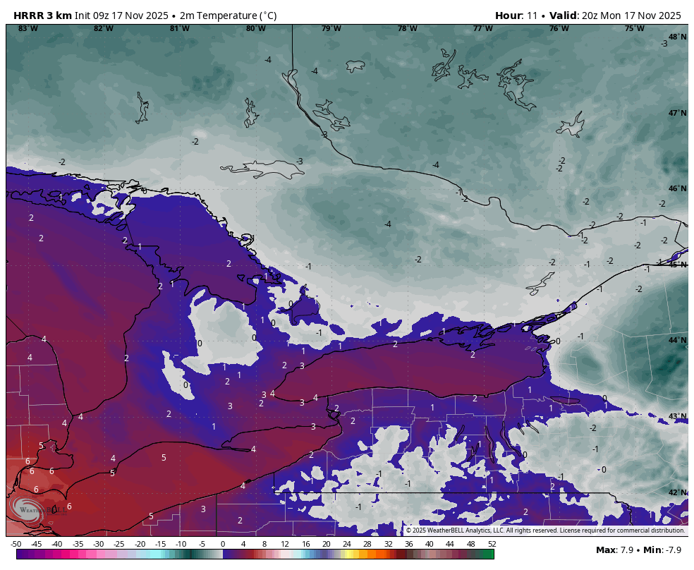
Chilly start to the day expected tomorrow across Southern #Ontario
Morning temps will range from the upper single digits to near 10°C
Scattered Lake effect showers likely for areas east of Lake #Huron/ #GeorgianBay
It will feel like late September/ October 🥶
#OnWX #ONStorm
English