NW Ohio Wx

22.9K posts

NW Ohio Wx banner
NW Ohio Wx

NW Ohio Wx

@NWOhioWeather

Williams, Fulton, Lucas, Ottawa, Defiance, Henry, Wood, Sandusky, Paulding, Putnam, Hancock, Seneca, Van Wert, Allen, Mercer, Auglaize, Hardin, and Wyandot.

Northwest Ohio #NWOhioWx Katılım Mart 2017
19 Takip Edilen1.4K Takipçiler
NW Ohio Wx
NW Ohio Wx@NWOhioWeather·
The NW Ohio 7 Day Forecast. #OHwx
NW Ohio Wx tweet media
English
0
1
3
205
NW Ohio Wx
NW Ohio Wx@NWOhioWeather·
Not much change in thinking of the #severe #weather risk for Thursday into Thursday Night. Very large hail and a tornado risk is likely. #OHwx
English
1
2
3
292
NW Ohio Wx
NW Ohio Wx@NWOhioWeather·
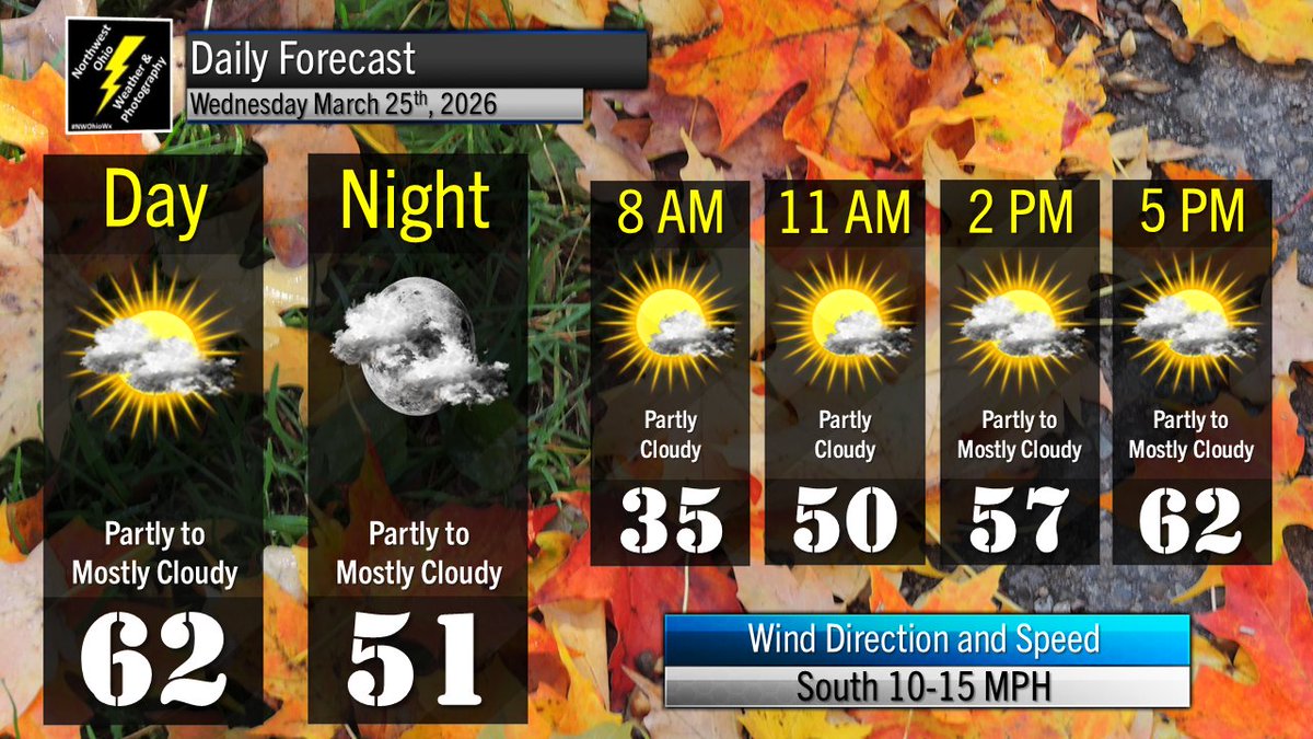
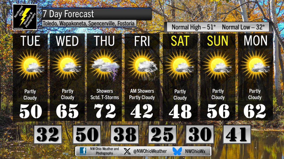
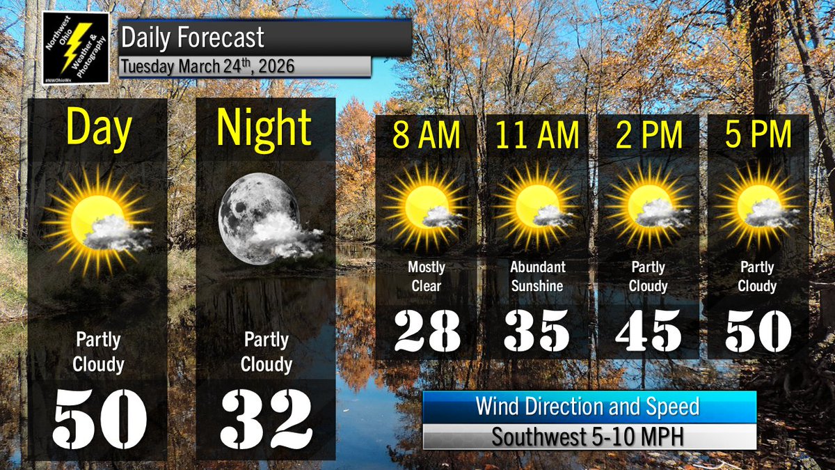
Mostly cloudy by Wednesday afternoon, continuing into the night. Highs in the low 60s. Lows in the lower 50s. #OHwx
NW Ohio Wx tweet media
English
0
1
1
122
NW Ohio Wx
NW Ohio Wx@NWOhioWeather·
Partly cloudy tonight with low temperatures in the mid 30s. #OHwx #weather
NW Ohio Wx tweet media
English
0
1
1
136
NW Ohio Wx
NW Ohio Wx@NWOhioWeather·
Quiet Tuesday afternoon with plenty of sunshine. Temperatures in the low to mid 40s. #OHwx #weather
NW Ohio Wx tweet media
English
0
1
1
137
NW Ohio Wx
NW Ohio Wx@NWOhioWeather·
Keeping close tabs on severe risk for Thursday. Greatest risk from large hail. #OHwx
NW Ohio Wx tweet media
English
0
1
6
234
NW Ohio Wx
NW Ohio Wx@NWOhioWeather·
The NW Ohio 7 Day Forecast. #OHwx
NW Ohio Wx tweet media
English
0
1
2
152
NW Ohio Wx
NW Ohio Wx@NWOhioWeather·
Partly cloudy Tuesday into Tuesday Night. Highs near 50°F. Lows in the lower 30s. #OHwx
NW Ohio Wx tweet media
English
0
0
2
130
NW Ohio Wx
NW Ohio Wx@NWOhioWeather·
Mostly clear tonight with low temperatures in the upper 20s. #OHwx
NW Ohio Wx tweet media
English
0
0
1
127
NW Ohio Wx
NW Ohio Wx@NWOhioWeather·
Severe storm near Portland #INwx moving east towards southern Mercer and SW Auglaize County. Ping pong ball size hail likely. #OHwx
NW Ohio Wx tweet media
English
0
0
4
284
NW Ohio Wx
NW Ohio Wx@NWOhioWeather·
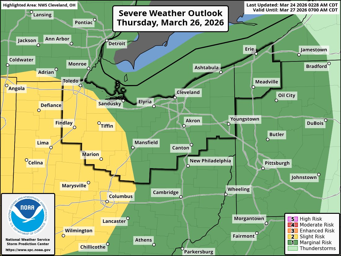
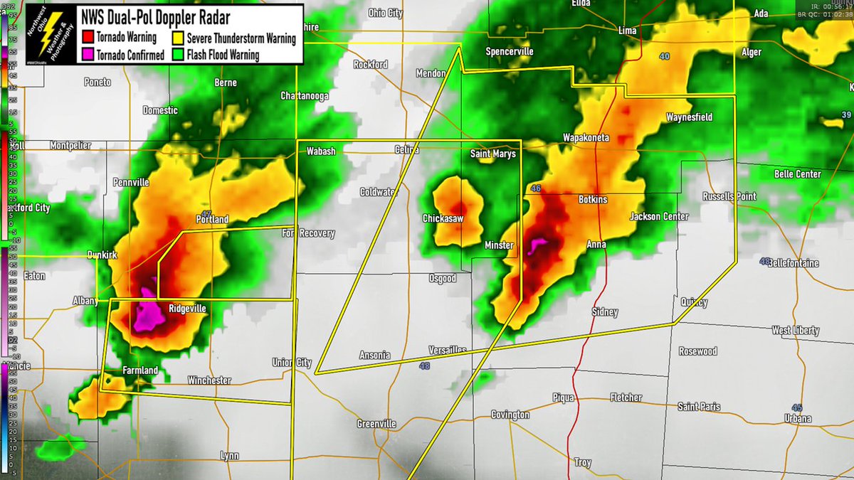
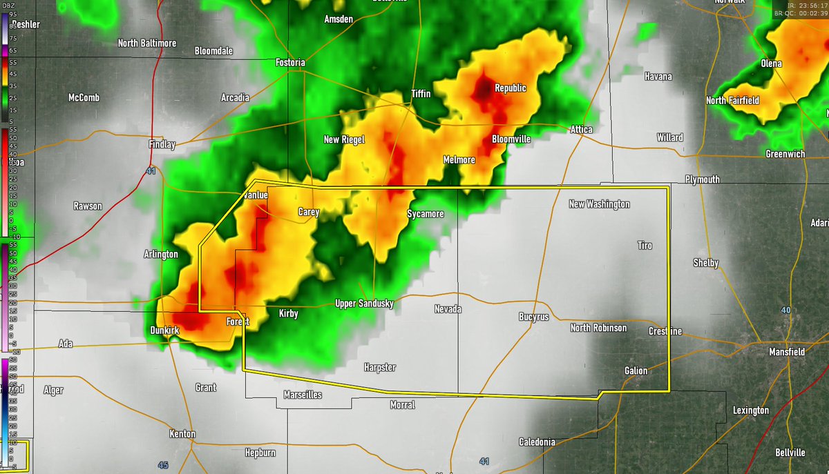
Storms along and south of US Hwy 30 will continue to present large hail risk through the evening. #OHwx
English
0
0
1
209
NW Ohio Wx
NW Ohio Wx@NWOhioWeather·
Clusters of severe storms moving east this evening. Quarter to half dollar size hail likely. #OHwx
NW Ohio Wx tweet media
English
0
0
1
230
NW Ohio Wx
NW Ohio Wx@NWOhioWeather·
Line of severe storms with half dollar to ping pong ball size hail moving towards Ada, Kenton, and Dunkirk in Hardin County. #OHwx
NW Ohio Wx tweet media
English
0
0
3
180
NW Ohio Wx retweetledi
Weston
Weston@Westonh776·
@NWOhioWeather Mendon got pounded by golfballs
English
0
1
1
98
NW Ohio Wx
NW Ohio Wx@NWOhioWeather·
Severe storm west of Upper Sandusky moving east. Quarter size hail has been reported. #OHwx
NW Ohio Wx tweet media
English
1
0
2
186
NW Ohio Wx
NW Ohio Wx@NWOhioWeather·
Severe storm over Rockford moving east. Quarter size hail and 60 MPH wind possible. #OHwx
NW Ohio Wx tweet media
English
3
0
1
216