NWS California-Nevada RFC

1.5K posts

NWS California-Nevada RFC banner
NWS California-Nevada RFC

NWS California-Nevada RFC

@NWSCNRFC

Official Twitter account for the National Weather Service California Nevada River Forecast Center or CNRFC, https://t.co/wpdBnfYjSp.

Sacramento, CA Katılım Temmuz 2012
132 Takip Edilen7.3K Takipçiler
NWS California-Nevada RFC retweetledi
NWS Sacramento
NWS Sacramento@NWSSacramento·
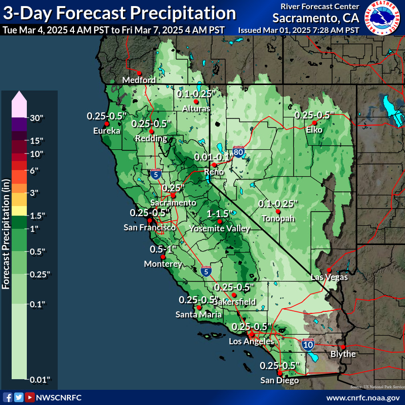
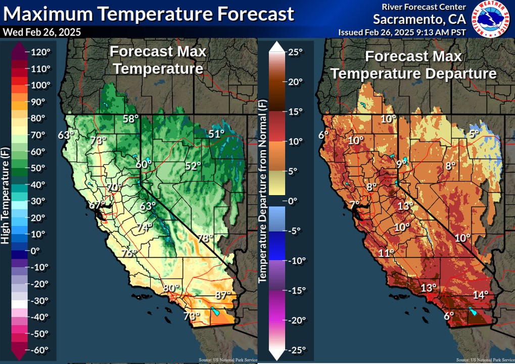
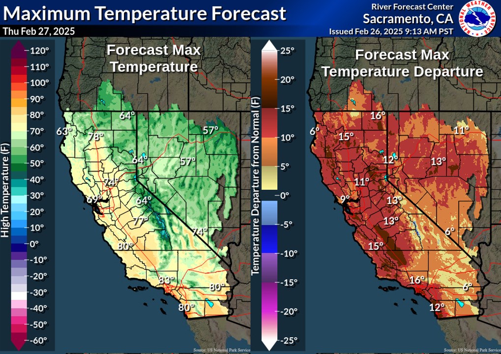
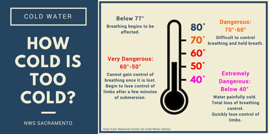
As warmer weather takes hold of the region over the next several days, remember that area waterways are still running fast and very cold due to mountain snowmelt. For current water temperatures around interior #NorCal, check out cnrfc.noaa.gov/?product=zeroh… 🌡️ #CAwx
NWS Sacramento tweet media
English
0
6
10
3.7K
NWS California-Nevada RFC
NWS California-Nevada RFC@NWSCNRFC·
As we near the peak snowmelt season, California reservoirs are in great shape with many nearing capacity and above historical averages. Shasta is 95% full (117% hist. avg), Oroville 91% full (120% hist. avg), and Folsom 93% full (137% hist. avg). Data: @CA_DWR #CAwater #CAwx
NWS California-Nevada RFC tweet media
English
5
46
202
11.8K
NWS California-Nevada RFC
NWS California-Nevada RFC@NWSCNRFC·
The past 7 days provided quite the boost to our 2025 Water Year precip totals. The "winners"? The King Range near Cape Mendocino and Smith River basin in Del Norte County saw amounts near 15"! The Sierra did well too, from 3" to 7", which helped build more snowpack! #CAwx #NVwx
NWS California-Nevada RFC tweet media
English
0
9
32
2.5K
NWS California-Nevada RFC
NWS California-Nevada RFC@NWSCNRFC·
With moderate to heavy precip falling across the northern CA coast today, the Smith R at Dr Fine Br is forecast to reach its "Action" stage around Noon, while the Mad R at Arcata is expected to reach its "Action" stage around Midnight. "Turn Around, Don't Drown". #CAwx #CAwater
NWS California-Nevada RFC tweet mediaNWS California-Nevada RFC tweet media
English
0
0
6
868
NWS California-Nevada RFC
NWS California-Nevada RFC@NWSCNRFC·
With another storm forecast to impact the region later Sat to Mon, rivers will respond with the Smith R at Dr Fine Br and Cosumnes R at Michigan Bar anticipated to exceed Action Stage. Ensembles also show a 61% and 57% chance of this occurring in the 5 day window. #CAwx #CAwater
NWS California-Nevada RFC tweet mediaNWS California-Nevada RFC tweet mediaNWS California-Nevada RFC tweet media
English
0
1
5
827
NWS California-Nevada RFC
NWS California-Nevada RFC@NWSCNRFC·
Past 72 hrs have been quite active for precip with coastal areas from 1-3", Central Valley 1/2" to 1", and Sierra from 2" to 4". With relatively low snow levels, the snowpack benefited nicely from these storms too, now ~90% of avg for the state (85% of Apr 1 avg). #CAwx #NVwx
NWS California-Nevada RFC tweet mediaNWS California-Nevada RFC tweet media
English
0
4
8
1K
NWS California-Nevada RFC
NWS California-Nevada RFC@NWSCNRFC·
Wet weather at times this week! A low moves into Srn CA for showers & isolated t-storms into tonight. A cold system moves ovr region Wed/Thu for more widespread precip. More chances of precip, mainly ovr N Fri-Sun. River levels will rise & few pnts reaching action stg #cawx
NWS California-Nevada RFC tweet mediaNWS California-Nevada RFC tweet mediaNWS California-Nevada RFC tweet media
English
0
1
5
716
NWS California-Nevada RFC retweetledi
California Department of Water Resources
Today’s snow survey results show a big regional disparity between the Northern, Central, and Southern Sierra Nevada snowpacks. Many storms this season missed the southern half of the state, so the statewide snowpack average masks just how below average some regions are. Because of this disparity, water managers will need to consider not just the extreme swings through the winter and spring months, but also the big differences from watershed to watershed.
California Department of Water Resources tweet mediaCalifornia Department of Water Resources tweet mediaCalifornia Department of Water Resources tweet media
English
3
3
12
1.9K
NWS California-Nevada RFC
Periods of precip for most of CA & NV in early March as a couple systems move through region, first one tonight-Mon & next one mid-week. Freezing levels drop to ~3500-5500 ft by Sun evening. Minor rises on rivers forecast across some coast & lower elevation basins #cawx #nvwx
NWS California-Nevada RFC tweet mediaNWS California-Nevada RFC tweet media
English
1
1
4
718
NWS California-Nevada RFC
NWS California-Nevada RFC@NWSCNRFC·
Above normal temperatures (5 to 20 degrees) over the region today and tomorrow. Warm temperatures will bring increased runoff in basins with melting low elevation snow the next couple days. Cooler with a chance of precip Saturday night into Monday. #cawx #nvwx
NWS California-Nevada RFC tweet mediaNWS California-Nevada RFC tweet mediaNWS California-Nevada RFC tweet media
English
0
1
5
571
NWS California-Nevada RFC
NWS California-Nevada RFC@NWSCNRFC·
Wet week to start February over most of the region. Highest precipitation amounts are around 13-26 inches over the Nrn Sierra and 9-20 inches over the Shasta Basin since Feb 1. More widespread precip is expected mid-late next week. #cawx #cawater #nvwx
NWS California-Nevada RFC tweet media
English
1
19
29
5.1K
NWS California-Nevada RFC
NWS California-Nevada RFC@NWSCNRFC·
Areas of heavier rainfall over Srn CA could produce sharp rises on rivers. The Santa Margarita River at Ysidora (27% chance) and San Diego River at Fashion Valley (11% chance) have a greater than 10% chance of action/monitor stage in the next five days. #cawx #cawater
NWS California-Nevada RFC tweet media
English
0
0
5
968
NWS California-Nevada RFC
NWS California-Nevada RFC@NWSCNRFC·
Showers & slight chance t-storms mainly ovr Central & Srn CA & most of NV into Monday. 1-3" fcst ovr transverse range to San Diego Cty Mtns & 0.75-1.5" Srn CA coast. Freezing levels drop to 3-5 kft Sun. Lingering showers Srn CA Tues-Wed. Precip in N late Thurs-Fri #CAwx #nvwx
NWS California-Nevada RFC tweet mediaNWS California-Nevada RFC tweet media
English
0
1
15
1.1K
NWS California-Nevada RFC
NWS California-Nevada RFC@NWSCNRFC·
As we end the "1st Quarter" of the 2025 WY, total precip as % of avg shows those areas running "ahead of the game" (northern CA, especially Eel/Russian and Sacramento basins), and those that are not (central/southern CA and NV, especially southern CA and southern NV). #CAwx #NVwx
NWS California-Nevada RFC tweet media
English
3
49
182
185.9K
NWS California-Nevada RFC
NWS California-Nevada RFC@NWSCNRFC·
A weaker system bringing periods of light to moderate precip to Srn OR & Nrn CA & portions of Central CA & NV into early Tuesday. Generally dry later Tues-early Friday except showers possible NW CA & Srn OR Cascades Wednesday. A stronger system expected late Fri-Saturday. #cawx
NWS California-Nevada RFC tweet mediaNWS California-Nevada RFC tweet media
English
0
2
10
1.3K
NWS California-Nevada RFC
NWS California-Nevada RFC@NWSCNRFC·
More precip, mainly light to moderate, is forecast over Srn OR & Nrn CA & portions of Central CA & Nrn NV tonight into early Tuesday. A few river locations remain above monitor stage and flow at Colusa and Fremont weirs. Additional precip expected next weekend! #cawx #Nvwx
NWS California-Nevada RFC tweet media
English
0
1
4
1K
NWS California-Nevada RFC
NWS California-Nevada RFC@NWSCNRFC·
How much precip fell over CA/NV in the last 48 hrs ending at 4 am today? Highest precip amounts were 3-6" with local amounts to ~8 inches along the Nrn CA coast & Shasta Basin. Rivers rose to monitor stage at several points & a few points to Minor flood stage. #cawx #cawater
NWS California-Nevada RFC tweet mediaNWS California-Nevada RFC tweet mediaNWS California-Nevada RFC tweet mediaNWS California-Nevada RFC tweet media
English
0
5
19
2K
NWS California-Nevada RFC
NWS California-Nevada RFC@NWSCNRFC·
After a prolonged dry spell to start the month of December, we are finally seeing a pattern shift that will bring widespread precip back to the region starting later today, especially northern CA. Here are forecast precip amounts through next Tuesday morning. #CAwx #NVwx
NWS California-Nevada RFC tweet media
English
3
17
64
8.2K
NWS California-Nevada RFC
NWS California-Nevada RFC@NWSCNRFC·
Fact of the Day: During the recent #AtmosphericRiver, Santa Rosa Airport saw 13.91", 41% what is normally observed in a year! Also: Ukiah: 8.51", 24% of a normal year Redding: 7.18", 21% of a normal year Red Bluff: 5.47", 24% of a normal year Image: @UWCIMSS #CAwx #CAwater
NWS California-Nevada RFC tweet media
English
5
36
116
16.9K