
Ian Patterson
325 posts
Ian Patterson
@Patty_Cake1993
#preds #vols #titans #weatherenthusiast #gamer
Hendersonville, TN Katılım Şubat 2026
61 Takip Edilen8 Takipçiler

The #Preds will not have the first pick in the 2026 NHL Draft.
English
@MaxGreenberg176 Sadly we are getting tom, who no fan wanted.
English

Well……..given how Chayka’s tenure ended in Arizona, he certainly wouldn’t have been my first choice as a GM. Glad he’s not coming to Nashville #NHL
Sportsnet@Sportsnet
Elliotte Friedman has learned the Maple Leafs have hired John Chayka as General Manager and Mats Sundin as Senior Executive Advisor.
English
Ian Patterson retweetledi

NEXT 5 Days 🌧️:
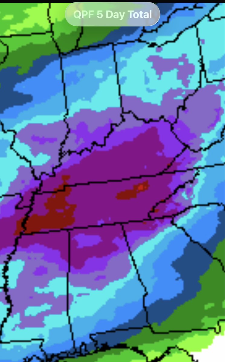
With the upcoming days ahead, a system will drape over the Region beginning Monday. Rounds of showers and impulses will spark some storm chcs as well. Could be Isol’d Severe Wx embedded given the wind energy, BUT beneficial rain chcs of 1.5”-2.5” are possible.
English
Ian Patterson retweetledi

David Pagnotta: Nashville, it sounds like anyway, that Tom Fitzgerald is a finalist for this [GM] position, frontrunner, however you wanna describe it; Scott White was tied to this as well; Brett Peterson; it sounds like they're getting there - Daily Faceoff Live (4/30)
English
Ian Patterson retweetledi
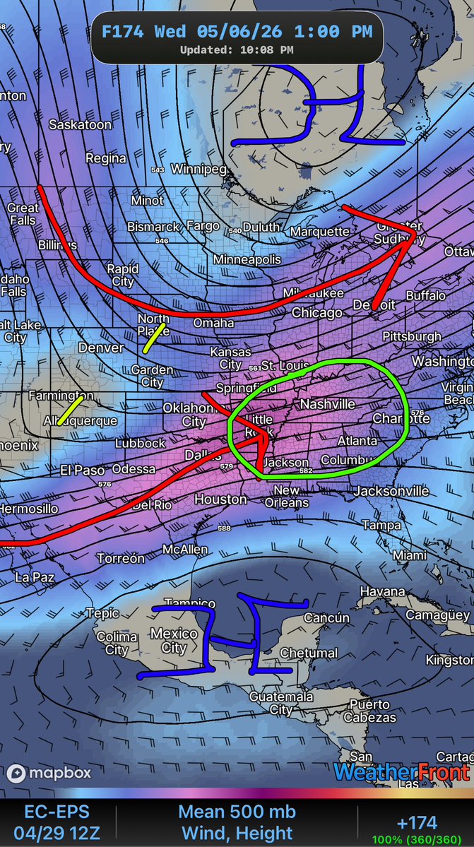
THURSDAYS ensemble trends for Next Wednesday Storm ⛈️ signal is still there. I think what I’ve noticed is the EURO is a touch more North than GFS with ensembles. Still shows a phase of both Jets. Moisture return will be something to watch as we get into the Weekend.


I-65 Weather (Kentucky)@I65WxSils
Down the Road ⛈️ Chc: (Weds May 6th) A quiet pattern for next several days til mid-Week. Looks like a polar and subtropical Jet will try to *phase* together that could yield to higher wind energy at Mid Levels. Confidence is still low at the moment as watch pattern recognition.
English
Ian Patterson retweetledi
New drought monitor map shows no change in our extreme and severe drought categories for this week. The data cutoff was Tuesday morning, so it does not include some of our latest rains. But still, drought is expected to persist.

English
If this is true, this organization will never be serious
NHL Rumour Report@NHLRumourReport
David Pagnotta: Re Predators GM search: I think Nashville might be leaning towards the Tom Fitzgerald route - DFO Rundown (4/29)
English
Ian Patterson retweetledi
NWS has confirmed a tornado in Davidson County at 2:28 am Tuesday morning (no surprise). It was rated EF-1 with max winds at 95 mph. The majority of the track was juuuust inside Robertson County along Dividing Ridge Road.

English
Ian Patterson retweetledi
Down the Road ⛈️ Chc:
(Weds May 6th)
A quiet pattern for next several days til mid-Week. Looks like a polar and subtropical Jet will try to *phase* together that could yield to higher wind energy at Mid Levels.
Confidence is still low at the moment as watch pattern recognition.
English
@katelynn2120342 @0meterChasers Expect below average temps through next week
English

@0meterChasers thank you mike! its chilly outside today in bg !
English

Drier and *chilier* Air is arriving on the backside of the Cold Front early this Afternoon along the 65 Corridor and West. Still a little bit of instability out there farther East along I-75 and into the Cumberland Plateau where some Isol’d showers have developed. Nothing severe today, maybe a little brief gusty wind with them. Skies will try to clear late into the Afternoon.
-Mike
English
Ian Patterson retweetledi

The NWS has completed their damage survey, and it’s now confirmed that an EF1 tornado touched down in Ridgetop along the Davidson/Robertson County line. The tornado was on the ground for about 2 minutes and traveled 1.29 miles.
Credit to the NWS for quickly identifying this fast-moving tornado and getting the warning out in time.
English


@NWSNashville I understand but with the downtrend in supportive environment for storms, I don’t understand why we are still outlooked as a slight risk through the late evening hours.
English
@Patty_Cake1993 SPC updated the outlook before the watch was canceled.
English
8:02 pm radar update:
Storms have weakened considerably since moving into Middle TN. That said, gusty winds between 40-50 mph remain possible along with heavy rain and lightning. #tnwx
English
@katelynn2120342 @I65WxSils I showered while it stormed lol
English
@I65WxSils would you say it would be safe to take a shower in this weather ? i really wanna shower and dont wanna wait but idk if ill get electrocuted lol
English
LOTS of Energy out there tonight across SoKY with all that Thunder and ⚡️… why??? It’s due to that high CAPE I mentioned. 2500 CAPE is good for lots of convection to occur.
Hope you’re enjoying the Light show out there!
I-65 Weather (Kentucky)@I65WxSils
CAPE is still there for storms to breathe in next few hours as they trek East.
English
Apparently we are still outlooked with a slight severe risk through the overnight hours.
Not sure why.
But here we are.
NWS Storm Prediction Center@NWSSPC
8:03pm CDT #SPC Day1 Outlook Enhanced Risk: across portions of northeast Texas, Arkansas, northern Louisiana, and Mississippi spc.noaa.gov/products/outlo…
English
I’d prefer it to underperform than seeing mass casualties.
Midwest Weather@MidwestWeathe_r
Yesterday underperformed. Tiny things can ruin big setups.
English
@SumnerSevereWx Weaker with dew points right at 70 is interesting.
English
New blog is up:
One more round of storms this evening (6–10 PM), but this setup is weaker than last night.
Main threats: wind & hail
Tornado risk: very low
Full breakdown + what to expect👇
sumnerseverewx.net/post/storm-upd…
I’ll be tracking it this evening
English
Ian Patterson retweetledi
We are yet again outlooked with severe probabilities today. Main threat will be damaging straight-line winds and hail. Tornado threat is very low but not zero. General timeframe will be 6-10p. More info in the blog/updates later this morning.

English
Ian Patterson retweetledi

7:02am CDT #SPC Day1 Outlook Enhanced Risk: across parts of the southern Plains into the lower Mississippi Valley and Mid-South spc.noaa.gov/products/outlo…
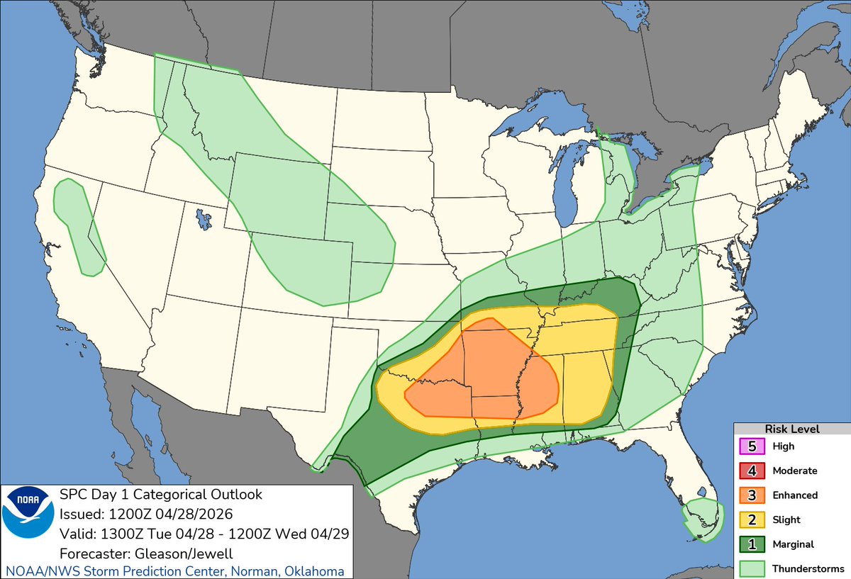
English