Sabitlenmiş Tweet

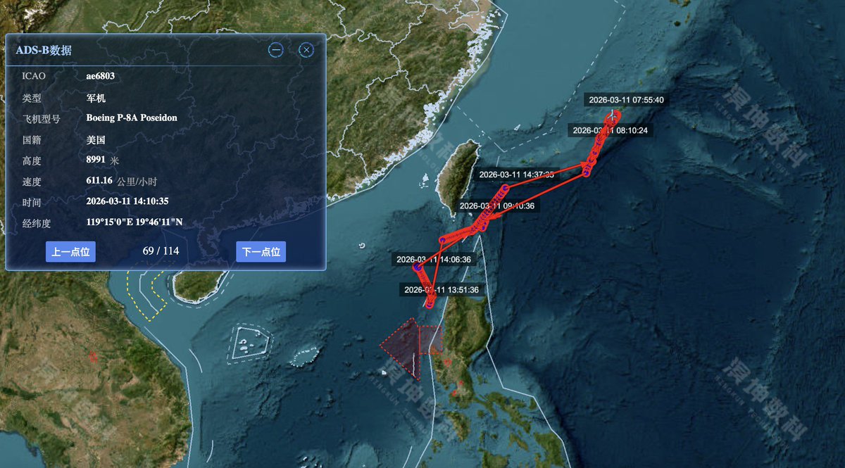
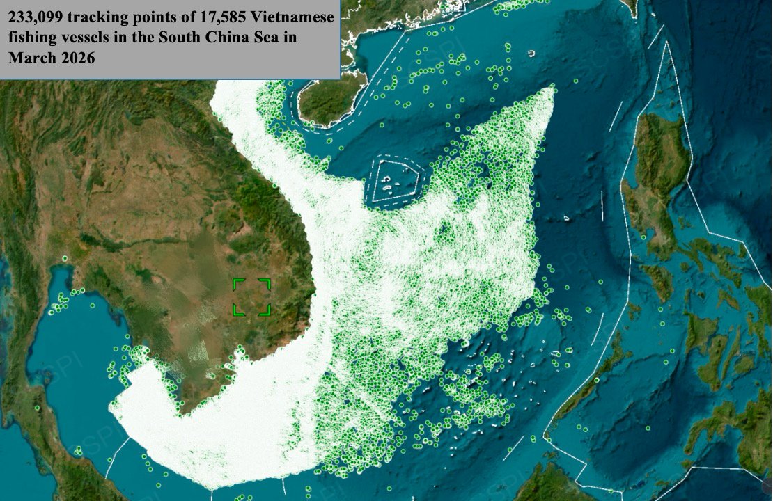
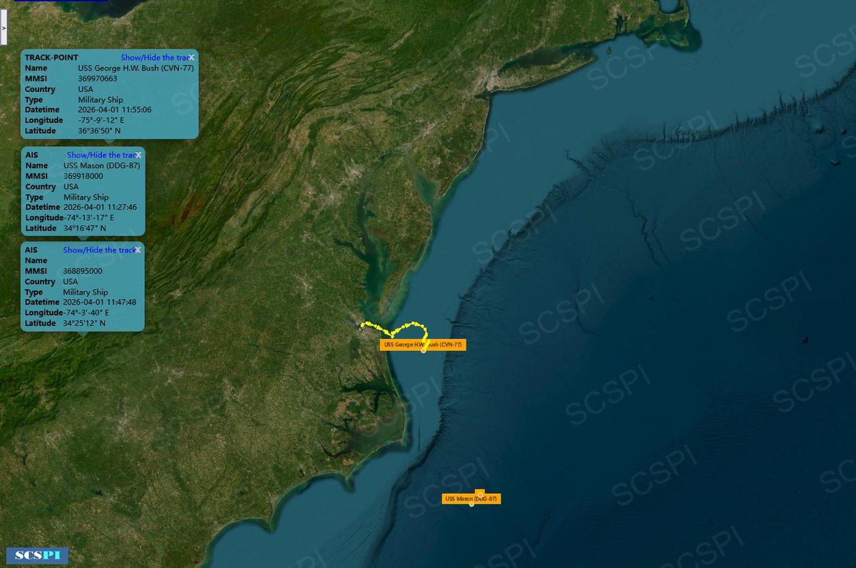
"The #SouthChinaSea is the most open sea in the world. Extra-regional militaries have over 8,000 ship-days naval presence and conduct nearly 10,000 sorties of military aircraft each year."
scspi.org/en/yjbg/report…
English
SCS Probing Initiative
3.5K posts

@SCS_PI
Dedicate to the transparency & development of the #SouthChinaSea, providing data & analysis, helping all parties mitigate competition and promote cooperation.


Corruption continues to be a major hindrance to trade and investments in the Philippines, according to the United States Trade Representative (USTR). “Corruption is a pervasive and longstanding problem in both the private and public sector in the Philippines,” the USTR said in the 2026 National Trade Estimate (NTE) report released on March 31, 2026. tinyurl.com/ydrde3wb
The problem with dealing with the People's Republic of China is that for them, if they have given something, no matter how big or small it is, they think that they can take everything from you, even your territory, sovereignty, and national identity. Let me borrow their line: No matter what calculations the Chinese government is making, they have nothing to do with sincerity.


President Ferdinand Marcos Jr. has ordered all of the more than 100 features in the Kalayaan Island Group (KIG) in the West Philippine Sea to bear local names in government documents and official maps of the country. Under Executive Order (EO) No. 111 issued on March 26, President Marcos ordered the adoption of the standard set of Philippine names for the 131 features of the KIG, which is part of the Kalayaan municipality in Palawan province. EO 111 directs the National Mapping and Resource Information Authority (Namria) to produce and publish updated charts and maps that reflect the local names. | @dexcabalzaINQ /PDI READ MORE: inqnews.net/LocalNamesKala…


Deputy Spokesperson of the Chinese Embassy Guo Wei: Mr. Jay Tarriela claims that the 1875 Carta General is one of the most complete and detailed official Spanish maps that clearly depicts philippine territories including Nansha Qundao (Spratly islands) and Huangyan Dao (Scarborough Shoal). He also claims that this map strengthens the historical basis for the Philippine position over these features. HE IS WRONG. First, the 1875 “Carta General del Archipiélago Filipino” is merely a geographical map of the Philippine archipelago. It contains no markings indicating sovereignty and therefore cannot substantiate claims that Huangyan Dao and the Nansha Qundao belong to the Philippines. Second, in the 1928 Island of Palmas Case, the United States presented a 1902 reproduction of this map by the U.S. War Department as evidence in an attempt to claim the island for the Philippines. However, the arbitrator, Max Huber—former President of the Permanent Court of International Justice—explicitly rejected the map on the grounds that it contained “no indication of political boundary.” Third, Panacot ≠ Huangyan Dao (Scarborough Shoal). Panacot refers to Marsingola, located between Galit and Lumbay. In the 1794 map drawn by Robert Laurie and James Whittle, Panacot is clearly identified as Marsingola, while the actual Huangyan Dao lies to the west of Panacot. This suggests that equating the two is based on a misreading of historical sources. Apparently, Mr. Tarriela has uncritically repeated the false narrative that “Panacot = Huangyan Dao” without even examining the original sources. At a time when both sides have agreed to pursue dialogue, distorting history and dismissing established legal reasoning serves no constructive purpose. It changes nothing on the ground. It only calls into question whether those doing so are truly invested in diplomacy, or simply determined to keep tensions alive.

U.S. Sailors and Marines aboard USS Tripoli (LHA 7) arrived in the U.S. Central Command area of responsibility, March 27. The America-class amphibious assault ship serves as the flagship for the Tripoli Amphibious Ready Group / 31st Marine Expeditionary Unit composed of about 3,500 Sailors and Marines in addition to transport and strike fighter aircraft, as well as amphibious assault and tactical assets.