STAR.VISION Aerospace

479 posts

STAR.VISION Aerospace banner
STAR.VISION Aerospace

STAR.VISION Aerospace

@STARVISION_cn

WE TRAIN WORLD MODELS. PIONEER IN AI-DRIVEN SATELLITE TECHNOLOGY.🛰️

Hongkong Katılım Ocak 2022
78 Takip Edilen642 Takipçiler
STAR.VISION Aerospace
STAR.VISION Aerospace@STARVISION_cn·
📍𝗧𝗼𝗸𝗺𝗼𝗸,𝗞𝘆𝗿𝗴𝘆𝘇𝘀𝘁𝗮𝗻: 𝗪𝗵𝗲𝗿𝗲 𝘁𝗵𝗲 𝗦𝗶𝗹𝗸 𝗥𝗼𝗮𝗱'𝘀 𝗘𝗰𝗵𝗼 𝗠𝗲𝗲𝘁𝘀 𝗢𝗿𝗯𝗶𝘁. 
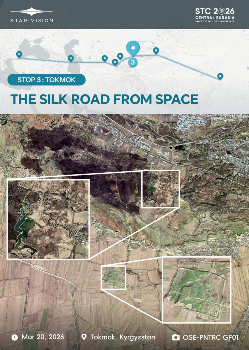
Continuing our orbital countdown to 𝗦𝗧𝗖 𝟮𝟬𝟮𝟲, we shift coordinates to the ruins of 𝗦𝘂𝘆𝗮𝗯 in Kyrgyzstan—a pivotal junction where East and West once converged. Sustained by fertile black soil and the 𝗖𝗵𝘂 𝗥𝗶𝘃𝗲𝗿, this region remains a masterclass in regional connectivity. These modern hydraulic structures drive a sophisticated agricultural engine, mirroring the irrigation intelligence that once fueled the Silk Road. Today, ancient ramparts overlap with these modern systems, showcasing a timeless continuity in resource management. The journey through Central Eurasia continues.Follow us as we map the places where history lives, and join us at #STC2026 in Uzbekistan to explore the next frontier of space-based connectivity. @Space_Tech_Conf @Azercosmos1 @METU_ODTU @Tubitak #STC2026 #SpaceTech #SatelliteImagery #Uzbekistan #STARVISION #RemoteSensing
STAR.VISION Aerospace tweet media
English
0
0
2
45
STAR.VISION Aerospace
STAR.VISION Aerospace@STARVISION_cn·
A Day of Tea, Culture, and Connection🍃 Our international interns from the Global Alliance had a wonderful team bonding experience today in the beautiful Longjing Village near West Lake, Hangzhou. We immersed ourselves in the city's renowned tea culture, learning about the rich traditions behind Longjing tea, while soaking in the breathtaking scenery that makes this place so special. Moments like these remind us that great collaboration happens not only in the office, but also when we step out, connect, and share experiences together. #TeamBuilding #TeaCulture #Hangzhou #InternationalInterns #STARVISION #OSE
STAR.VISION Aerospace tweet media
English
1
1
0
46
STAR.VISION Aerospace
STAR.VISION Aerospace@STARVISION_cn·
𝗜𝗹𝗶: 𝗪𝗵𝗲𝗿𝗲 𝘁𝗵𝗲 𝗥𝗶𝘃𝗲𝗿 𝗖𝗼𝗻𝗻𝗲𝗰𝘁𝘀. Continuing our orbital countdown to 𝗦𝗧𝗖 𝟮𝟬𝟮𝟲, we shift our coordinates to the 𝗜𝗹𝗶 𝗥𝗶𝘃𝗲𝗿 𝗩𝗮𝗹𝗹𝗲𝘆—a vital cultural hub of the Silk Road. The Ili River remains the vital pulse for the agricultural grid, powering civilizations for centuries. Parallel to this green belt, we identify a high-density urban matrix: home to 40+ ethnic groups living in unique spatial harmony. From orbit, the blue hues and geometric precision of traditional dwellings reveal the living DNA of this multicultural crossroads. The journey continues. Follow our path to the heart of Central Asia. And Join us at #STC2026 in Uzbekistan to explore how space intelligence empowers regional connectivity. @Space_Tech_Conf @Azercosmos1 @METU_ODTU @Tubitak #STC2026 #SpaceTech #SatelliteImagery #Uzbekistan #STARVISION #RemoteSensing
STAR.VISION Aerospace tweet media
English
0
0
0
32
STAR.VISION Aerospace
STAR.VISION Aerospace@STARVISION_cn·
🛰 Satellites & AI: The Rise of Space Data Centers As Earth observation satellites collect ever-growing volumes of data, a new paradigm is emerging: processing information directly in orbit. Instead of sending all raw data to the ground, satellites can analyze imagery and signals in space, dramatically reducing latency. With onboard AI computing, satellites can detect patterns, extract insights, and respond faster to events on Earth. Space is evolving from a sensing layer into a distributed data center in orbit. #STARVISION #AIinSpace #EarthObservation #SpaceInfrastructure
STAR.VISION Aerospace tweet media
English
0
1
2
44
STAR.VISION Aerospace
STAR.VISION Aerospace@STARVISION_cn·
🐫 𝗫𝗶’𝗮𝗻: 𝗪𝗵𝗲𝗿𝗲 𝘁𝗵𝗲 𝗦𝗶𝗹𝗸 𝗥𝗼𝗮𝗱 𝗕𝗲𝗴𝗮𝗻. We initiate our orbital countdown to 𝗦𝗧𝗖 𝟮𝟬𝟮𝟲 at the historic coordinates. Our imagery delineates the precise geometric contrast between the 𝗔𝗻𝗰𝗶𝗲𝗻𝘁 𝗖𝗶𝘁𝘆 𝗪𝗮𝗹𝗹—the historic nexus where caravans once gathered—and the high-density modern urban matrix. Looking closer, we spot the iconic 𝗚𝗶𝗮𝗻𝘁 𝗪𝗶𝗹𝗱 𝗚𝗼𝗼𝘀𝗲 𝗣𝗮𝗴𝗼𝗱𝗮, a millennium-old beacon of cultural exchange. Following this legendary path from orbit, we are building the future of space-based connectivity. Join us at #STC2026 in 𝗨𝘇𝗯𝗲𝗸𝗶𝘀𝘁𝗮𝗻 to explore the next frontier. @Space_Tech_Conf @Azercosmos1 @METU_ODTU @Tubitak #STC2026 #SpaceTech #SatelliteImagery #Uzbekistan #XiAn #STARVISION #RemoteSensing #HistoryMeetsTechnology
STAR.VISION Aerospace tweet media
English
0
0
1
39
STAR.VISION Aerospace
STAR.VISION Aerospace@STARVISION_cn·
The Green Lungs of the Desert: Qatar’s Al Thakira Mangroves🌿 Desert, city, and emerald waters converge in one frame. Al Thakira is Qatar’s oldest ecosystem—a vital "natural infrastructure" for carbon sequestration and coastal resilience. Protecting this resilience requires more than just observation.🛰️ STAR.VISION’s Mangrove007 platform fuses satellite data with AI agents, delivering the actionable insights needed to monitor and protect these critical ecosystems worldwide. 🌍Explore at: 👉mangrove007.com #STARVISION #Mangrove007 #Sustainability #ClimateTech #AI #EarthObservation #Qatar
STAR.VISION Aerospace tweet media
English
0
0
1
56
STAR.VISION Aerospace
STAR.VISION Aerospace@STARVISION_cn·
How can space technology move the needle for local economies? At STC 2026 in Tashkent, STAR.VISION will showcase how Spatio-Temporal Intelligence (STI) transforms Earth Observation into a primary economic driver. By "Training World Models”, we convert raw pixels into the actionable insights needed to power sustainable growth across Central Eurasia—from precision agriculture to infrastructure monitoring. 🗓Date: March 30 – April 1, 2026 📍Venue: Intercontinental Hotel, Tashkent 📍Find us at: Booth 9 Let’s talk about the next generation of Space+AI. #SpaceTech #AI #WorldModels #STC2026 #STARVISION #EarthObservation #RemoteSensing #Innovation
STAR.VISION Aerospace tweet media
English
0
0
0
74
STAR.VISION Aerospace
STAR.VISION Aerospace@STARVISION_cn·
🛰 Satellites & AI: Monitoring Glaciers from Space 🛰 How do satellites monitor glaciers? Satellite imagery allows us to measure glacier area and elevation, tracking changes across large and remote regions over time. 🌍 Why does it matter? Glacier retreat affects freshwater availability, regional ecosystems, and long-term climate stability. 🤖 Where does AI come in? AI analyzes satellite imagery to automatically detect glacier boundaries, monitor ice dynamics, and quantify long-term changes. 💥 Real impact Monitoring glacier retreat helps scientists understand water availability and environmental change in Antarctica. Protect glaciers = protect water, food, and human survival. #SpaceAI #GlacierMonitoring #RemoteSensing #ClimateScience #STARVISION #EarthObservation
STAR.VISION Aerospace tweet media
English
0
0
2
51
NASA Mars
NASA Mars@NASAMars·
Our Eye on Mars 🔴 As it marks 20 years at the Red Planet, here are five ways @NASA's Mars Reconnaissance Orbiter (MRO) is mapping the future of exploration. 🛰 ➠ 👩‍🚀 🧵 1/6
English
54
431
2.3K
198.6K
STAR.VISION Aerospace
STAR.VISION Aerospace@STARVISION_cn·
Nairobi Floods: How Satellite Intelligence Supports Disaster Response Severe flash floods struck Nairobi, Kenya on March 6–7, claiming more than 25 lives and displacing thousands across the city. When disasters unfold, the first hours are critical. Satellite observations can provide rapid situational awareness to support emergency response teams navigating flooded streets and damaged infrastructure. Using satellite imagery and geospatial analysis, flooded zones and affected urban areas can be quickly identified to help responders understand the evolving situation on the ground. Satellite intelligence enables teams to better assess impacted areas, understand infrastructure disruptions, and coordinate response efforts more effectively. Our thoughts are with everyone affected by the floods in Nairobi and the communities continuing recovery. @SpaceAgencyKE #STARVISION #DisasterResponse #SatelliteData #EarthObservation #Kenya
STAR.VISION Aerospace tweet media
English
0
0
5
116