Micheal Lavender retweetledi
Micheal Lavender
1K posts


Micheal Lavender
@SkySPOT97
Severe WX | Tweeting from The Jungle | Respect the Polygon | KI5IZM
Tyler, TX Katılım Mart 2016
343 Takip Edilen348 Takipçiler


Micheal Lavender retweetledi

The SPC had expanded #tornado probabilities with strong-to-violent, longtrack tornadoes possible from Iowa to Arkansas. A dangerous day is ahead. These will be very fast-moving. Please give these tornadoes breathing room

English
Micheal Lavender retweetledi

Micheal Lavender retweetledi

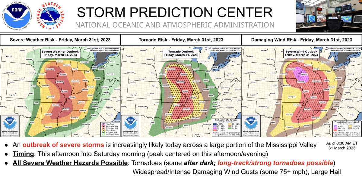
A severe weather outbreak appears increasingly likely this afternoon/evening across a large portion of the Mississippi Valley. At least a few long-track, strong to potentially violent tornadoes are probable. Swaths of intense damaging wind and very large hail are also expected.
English
Hey local followers… @BrandonCopicWx is in the house… and this is his ‘day job’… so, if that’s the indication you need, you’ve been put on notice. #TylerTexas
Brandon Copic@BrandonCopicWx
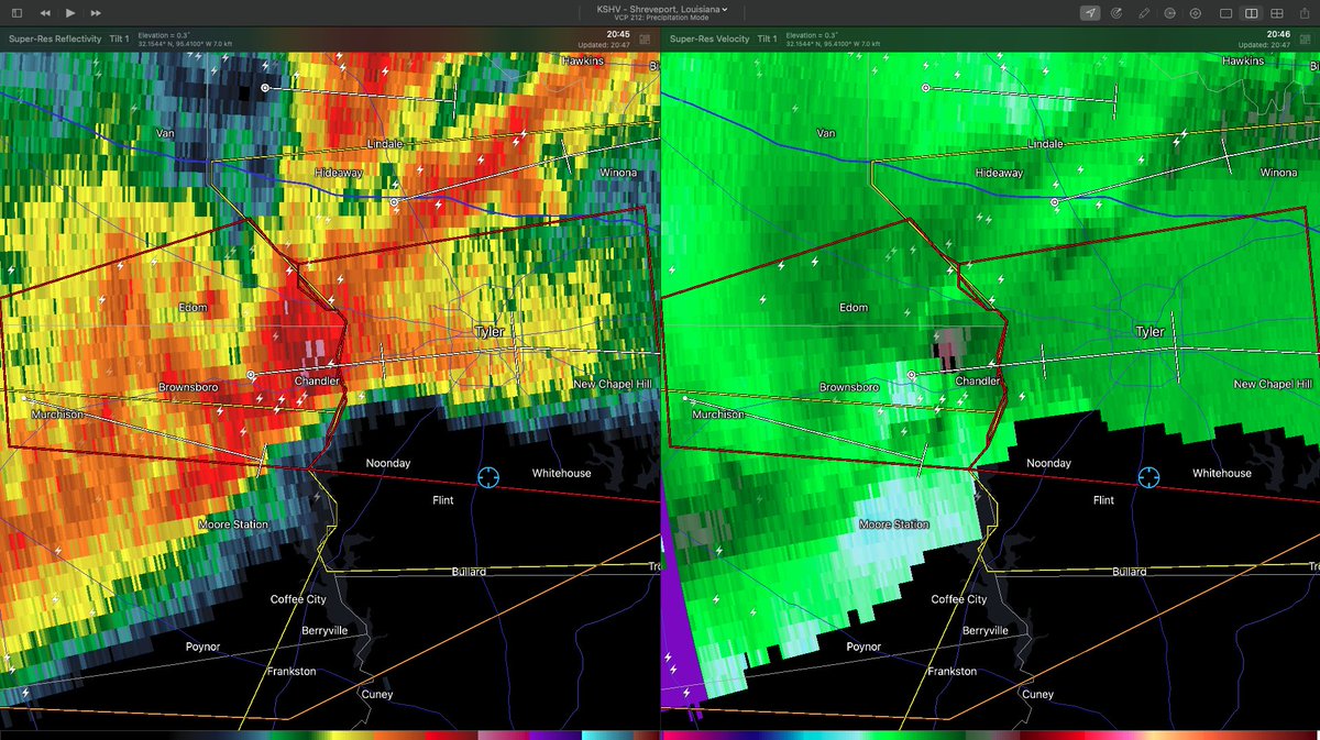
LIVE from a TORNADO WARNING in Tyler, TX on @RadarOmega and YouTube: ChaserWx.Net #TXwx
Texas, USA 🇺🇸 English
Ok #TylerTexas this is a rare one from me. Be on alert. This is likely a legitimate concern. I’ve yet to see on-the-ground confirmation (not chasing tonight). #tornado
Tyler, TX 🇺🇸 English
Micheal Lavender retweetledi
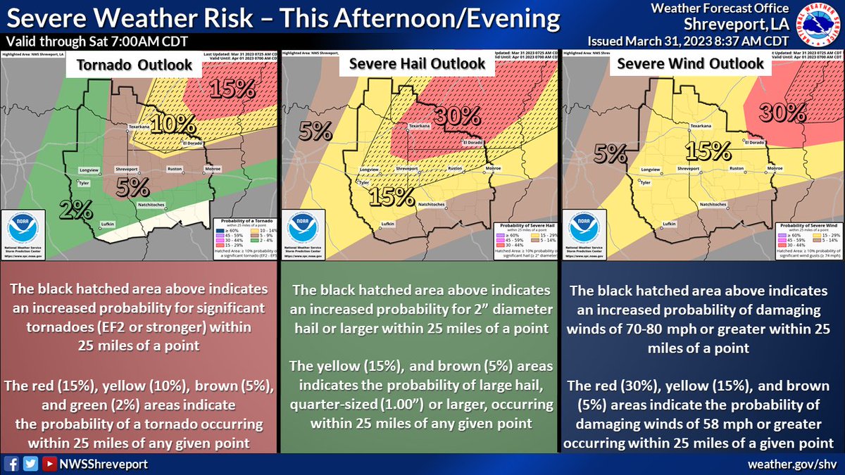
Severe weather is likely across the region Thursday into Thursday night. This graphic shows the tornado, severe hail and wind outlooks. Areas in the significant hatched outline have the best chance to see strong EF2 or greater tornadoes, winds of 70-80 mph and 2" hail or greater.

English
@WxLiz @NWSSPC So… I will just assume *this* tweet was merely foreshadowing for today’s historic moment! 🤓 Congratulations @WxLiz!!! #severewx #WomenInSTEM
Texas, USA 🇺🇸 English
Micheal Lavender retweetledi

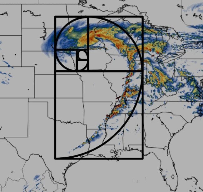
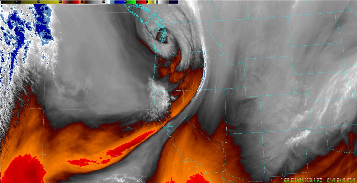
Peekaboo! We spot a curlicue. And that little circulation over the Pacific Northwest -- is going to evolve into our next weather maker. Let's talk about it!
A thread...
1/
English
@NWSLosAngeles @NWS Hey @NWSShreveport when does our “water year” start? I’ve always assumed 1/1. Need to change my @davisinst console if otherwise.
English

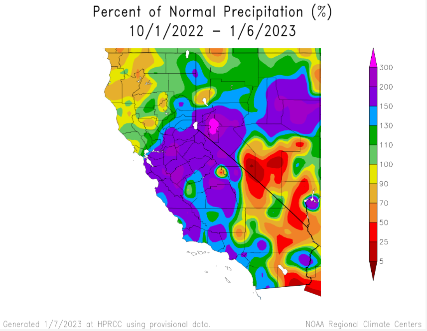
Check this out!!!!
Here's the % of normal rainfall that CA has received from Oct 1st to Jan 6th (water year begins Oct 1st).
Very good so far for the southern 2/3 of the state. With more significant rain expected over the next 7 days, these % will look even better. #CAwx
English
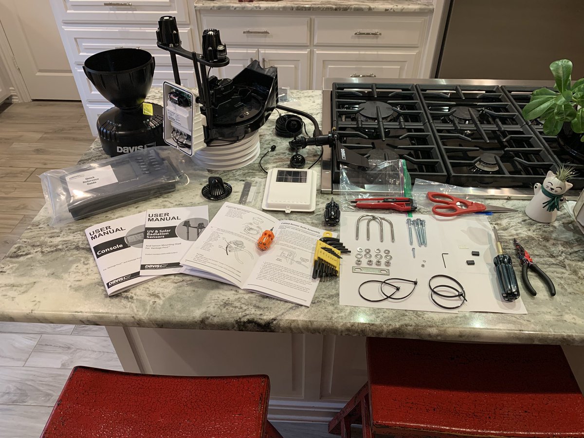
I’m just gonna call it like it is… #wxnerds get the *best* Christmas gifts. Period. #wxtwitter #txwx #etxwx @davisinst @NWS @NWSShreveport

Tyler, TX 🇺🇸 English
Micheal Lavender retweetledi
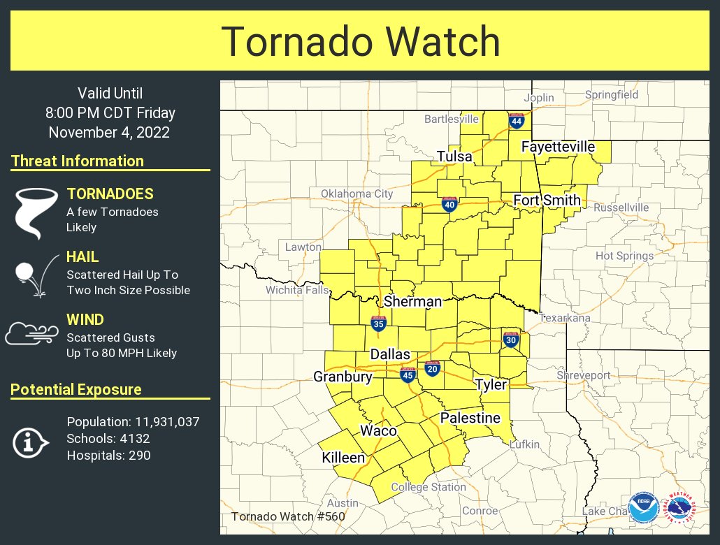
A tornado watch has been issued for parts of Arkansas, Oklahoma and Texas until 8 PM CDT
Texas, USA 🇺🇸 English
Micheal Lavender retweetledi
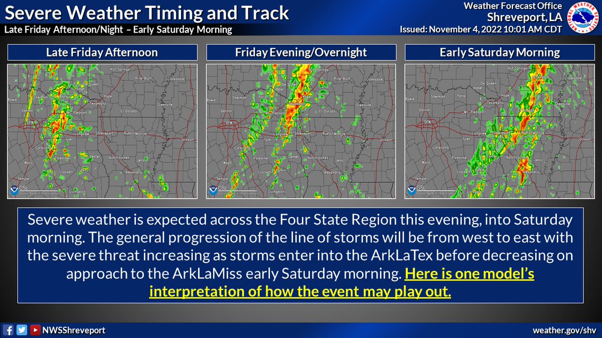
Continuing to monitor the threat for severe storms later this afternoon, through the evening and into the overnight hours across the Four State Region. It is important to note that this is one model's interpretation of what the radar may look like as the front moves through.
English
Micheal Lavender retweetledi
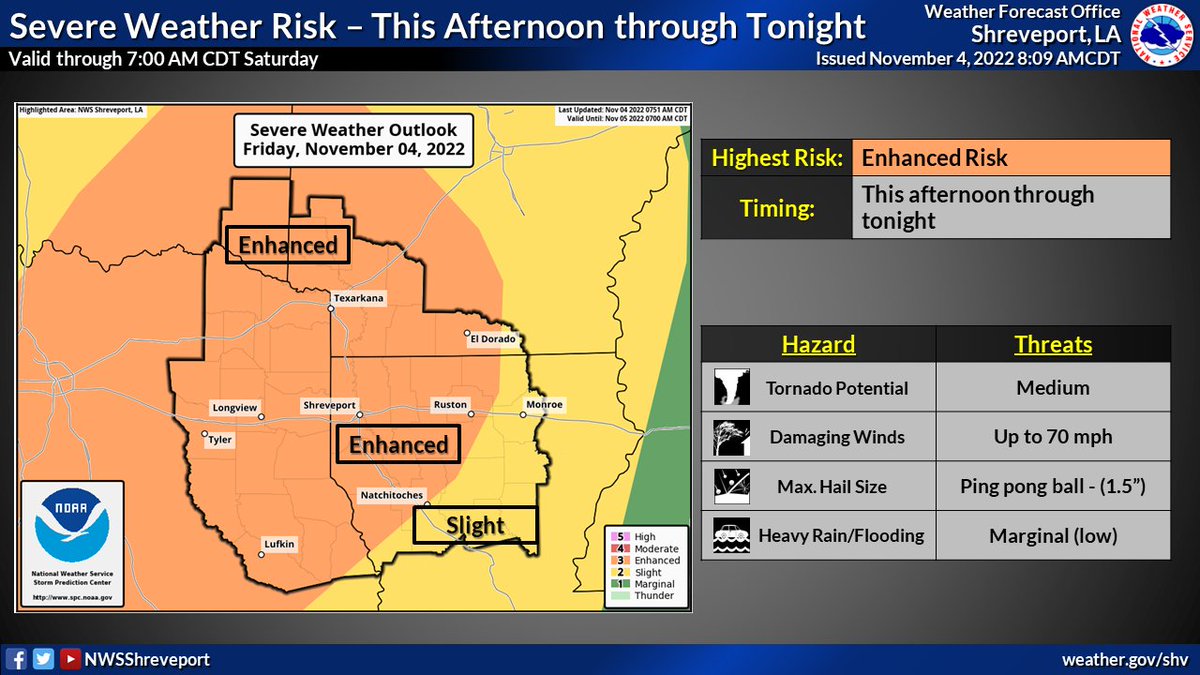
There is an Enhanced Risk of severe weather for much of the region this afternoon and continuing through the overnight hours. Damaging winds, large hail, and tornadoes will all be possible. A few particularly strong and significant tornadoes also cannot be ruled out. #severewx

English
Micheal Lavender retweetledi
7:53am CDT #SPC Day1 Outlook Enhanced Risk: over portions of central, north-central, east and northeast Texas, southeastern Oklahoma, western/southern Arkansas, and northern Louisiana spc.noaa.gov/products/outlo…

English
While known to be “excitable,” there’s *no* question of his acumen and insight. Take note #etxwx. It’s gonna be “a day.” #severewx
Reed Timmer, PhD@ReedTimmerUSA
Tornado outbreak with threat of strong-to-violent tornadoes appears increasingly likely today across central and eastern TX into southeastern OK including DFW to just southeast/east of OKC through the Arklatex tonight. Emergency storm chase mode activated
English
Micheal Lavender retweetledi
1:01am CDT #SPC Day2 Outlook Enhanced Risk: across northeast Texas into southeast Oklahoma and far southwest Arkansas spc.noaa.gov/products/outlo…

English
Betting windows are open! Wagers on the triple point plotting, anyone? #etxwx @docdeason @HookSurfers @etxwx_josh @klindek @cslavender @matusk95 @EricHippler
English