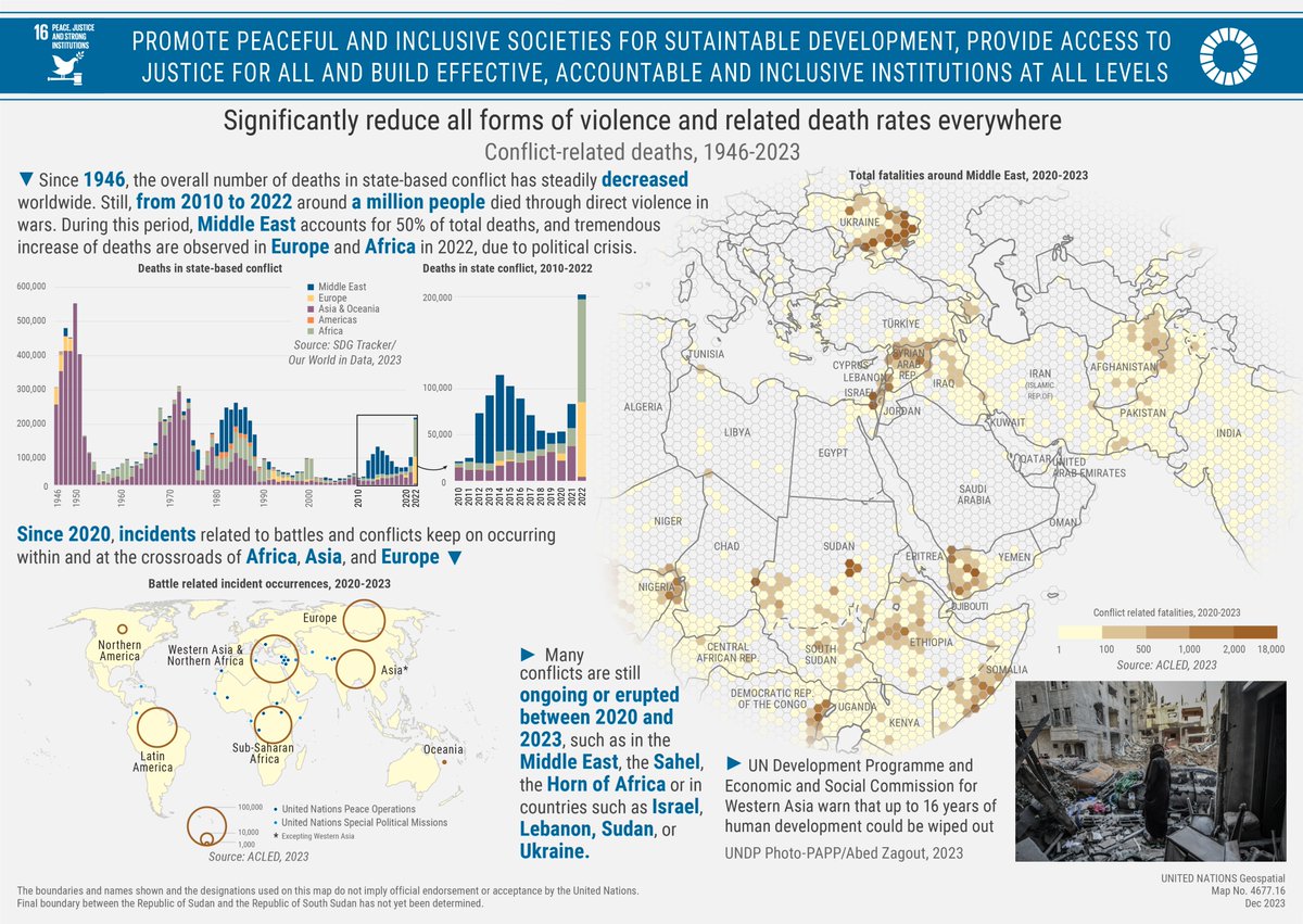
This @UN_Geospatial map tracking #SDG16, to significantly reduce all forms of violence and death rates everywhere, shows the disaggregate ongoing and increasing death rates in some regions using ACLED data. View it now:
This @UN_Geospatial map tracking #SDG15, which aims to protect, restore and promote sustainable use of terrestrial ecosystems and keep forests safe from degradation, shows the disaggregate Normalized Density Vegetation Index (NDVI) across Southern Africa in the last decade.
This @UN_Geospatial map demonstrates #SDG14 through disaggregate rates of Bluefin Tuna catches across the oceans, and particularly for the Mediterranean Sea, which might lead to this vital species’ extinction.
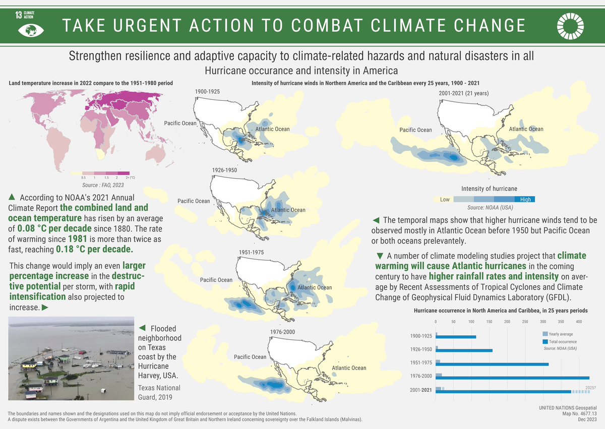
This @UN_Geospatial map on #SDG13 demonstrates the global increase of land temperature in 2022. As an example of changing climate patterns, the map shows data on the rising intensity of hurricanes over Northern America, disaggregated by geographic location and in time.
#SDG12 encourages more sustainable consumption and production patterns through various measures. This @UN_Geospatial map identifies disaggregate food loss and waste in Western Africa and its correlation to food insecurity. Look now:
#SDG11 aims to provide access to safe, affordable, accessible and sustainable transportation for all.
Our @UN_Geospatial team created this map to track show how disaggregate data by city can show the proportion of people who have convenient access to public transport worldwide.
This @UN_Geospatial map on #SDG10 demonstrates the global trends in the number of people who have died or gone missing in the process of irregular migration. It also highlights the disaggregated number of people missing or dead en route to Europe from Western and Northern Africa.
The following @UN_Geospatial map tracks #SDG8 through the rate of youth not in education, employment or training (NEET) by regions worldwide. The map shows disaggregated NEET within European countries by subnational units or “NUTS”. Look at the numbers now:
Today’s @UN_Geospatial map on #SDG7, to ensure access to affordable, reliable, sustainable and modern energy for all, represents the share of renewable energy Worldwide and across regions of various countries in Southern Asia.
Check out the map now:
The aim of #SDG6 is to ensure availability and sustainable management of water and sanitation for all. The following map, created by @UN_Geospatial, highlights water stress and river discharge conditions throughout Northern Africa and much of Asia.
#SDG5 seeks to achieve gender equality and empower all women and girls across the globe!
@UN_Geospatial has created the following map to track how much of our world’s agricultural land is managed by women, specifically in Western Europe. The data represented is fascinating.
Today’s #SDG4 map, about ensuring inclusive and equitable education for all, tracks the completion rate of primary education. The map highlights challenges globally, specifically Sub-Saharan Africa and Oceania.
As previously published #SnakebiteAwarenessDay, our #sdg3#goodhealth map presents snake habitat suitability in South America and how #climatechange will affect it!
Around 100 thousand people die each year because of snake bites!
#DYK that climate change attributed to a loss of $4.3T US dollars globally from 1970-2021?
The first map of our @UN_Geospatial campaign focuses on #SDG1 and highlights how poverty is a driver and result of environmental disasters, specifically in South and Southeast Asia:
As part of the @UN_Geospatial#SDG mapping campaign, we’re releasing the following map, tracking the relationship between the prevalence of undernourishment and wheat production across South America!
We need to recommit to the #GlobalGoals for better future for all.
The SDG Summit in September is a key moment to put the world back on track for a fairer, more inclusive & sustainable planet. un.org/sustainabledev…
📢 GRASS GIS 7.8.8 released 🙌
It provides more than 80 improvements and fixes compared to the 7.8.7 release. Be ware that it is expected to be the last 7.8 release.
Development continues with GRASS GIS 8.x. 🚀
grass.osgeo.org/news/2023_08_0…@OSGeo
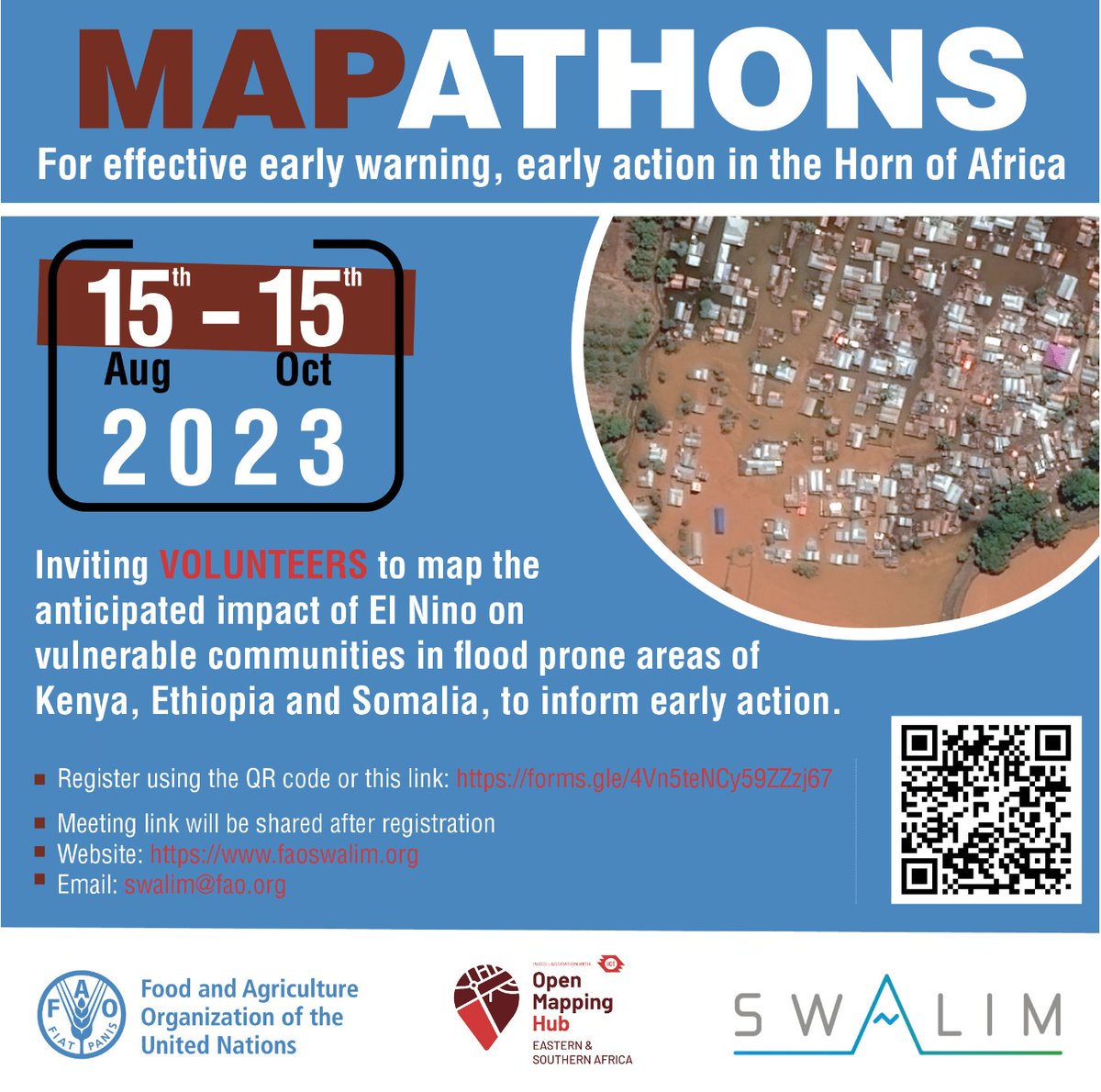
🌍 GIS Volunteers Needed! 🗺️
Join the @openmapping_esa and the @FAO in our mission to tackle the anticipated El Niño! 👉 Join our kick-off mapathon tomorrow!
✨ All levels are welcome.
For more details, visit hotosm.org/updates/mappin…